
During a USGS Hawaiian Volcano Observatory monitoring overflight the morning of September 18, geologists observed only very weak activity at Kīlauea's middle East Rift Zone eruption site in Nāpau Crater.
Multimedia
Images

September 18, 2024 —Kīlauea middle East Rift Zone eruption
During a USGS Hawaiian Volcano Observatory monitoring overflight the morning of September 18, geologists observed only very weak activity at Kīlauea's middle East Rift Zone eruption site in Nāpau Crater.

September 18, 2024 —Kīlauea middle East Rift Zone eruption
Weak low fountaining in a tiny lava pond within Nāpau Crater was visible during a morning Hawaiian Volcano Observatory eruption monitoring overflight on September 18, 2024. The eruptive activity has greatly decreased compared to yesterday. USGS photo by H. Winslow.
Weak low fountaining in a tiny lava pond within Nāpau Crater was visible during a morning Hawaiian Volcano Observatory eruption monitoring overflight on September 18, 2024. The eruptive activity has greatly decreased compared to yesterday. USGS photo by H. Winslow.

September 18, 2024 —lava spattering during the Kīlauea middle East Rift Zone eruption
From the ground in Nāpau Crater, spattering lava was visible above the newly formed lava flows. This eruption is taking place on the remote middle East Rift Zone of Kīlauea, within Hawaiʻi Volcanoes National Park. USGS photo by H. Winslow.
From the ground in Nāpau Crater, spattering lava was visible above the newly formed lava flows. This eruption is taking place on the remote middle East Rift Zone of Kīlauea, within Hawaiʻi Volcanoes National Park. USGS photo by H. Winslow.

September 18, 2024 —lava oozes during the active Kīlauea eruption
Although most of the lava flow field within Nāpau Crater was inactive this morning, lava was actively oozing out of a marginal area. USGS photo by H. Winslow.
Although most of the lava flow field within Nāpau Crater was inactive this morning, lava was actively oozing out of a marginal area. USGS photo by H. Winslow.

September 18, 2024 — Steam and volcanic gas on Kīlauea East Rift Zone
Steam and volcanic gas continue to be emitted from the first fissures that erupted the night of September 15 on the middle East Rift Zone of Kīlauea, west of Nāpau Crater. This photo, taken during morning monitoring overflight, looks southeast. USGS photo by H. Winslow.
Steam and volcanic gas continue to be emitted from the first fissures that erupted the night of September 15 on the middle East Rift Zone of Kīlauea, west of Nāpau Crater. This photo, taken during morning monitoring overflight, looks southeast. USGS photo by H. Winslow.

September 18, 2024 —Kīlauea middle East Rift Zone eruption reference map
This reference map depicts fissures and lava flows from the Kīlauea middle East Rift Zone eruption as of the end of the day on Wednesday, September 18, 2024. Areas in bright red represent new lava flows since the area was last mapped during the morning of September 17, when activity was focused within Nāpau Crater.
This reference map depicts fissures and lava flows from the Kīlauea middle East Rift Zone eruption as of the end of the day on Wednesday, September 18, 2024. Areas in bright red represent new lava flows since the area was last mapped during the morning of September 17, when activity was focused within Nāpau Crater.
Videos

September 17, 2024 —Kīlauea middle East Rift Zone eruption overflight
Kīlauea volcano is erupting in Hawai’i Volcanoes National Park from a new fissure vent that opened within Nāpau Crater this morning, September 17, between 4:00 and 5:00 AM HST. The eruption is occurring within a closed and remote area of Hawaiʻi Volcanoes National Park.
Kīlauea volcano is erupting in Hawai’i Volcanoes National Park from a new fissure vent that opened within Nāpau Crater this morning, September 17, between 4:00 and 5:00 AM HST. The eruption is occurring within a closed and remote area of Hawaiʻi Volcanoes National Park.

September 17, 2024 —Kīlauea middle East Rift Zone eruption sampling
USGS Hawaiian Volcano Observatory geologists collected a sample of the middle East Rift Zone Kīlauea eruption in Nāpau Crater, within a closed area Hawaiʻi Volcanoes National Park. Geologists put molten lava into a metal bucket and rapidly quench it with water.
USGS Hawaiian Volcano Observatory geologists collected a sample of the middle East Rift Zone Kīlauea eruption in Nāpau Crater, within a closed area Hawaiʻi Volcanoes National Park. Geologists put molten lava into a metal bucket and rapidly quench it with water.

September 16, 2024—Brief eruption near Nāpau Crater on Kīlauea Middle East Rift Zone
During a USGS Hawaiian Volcano Observatory overflight at approximately 10:30 a.m. HST on September 16, geologists observed freshly erupted lava west of Nāpau Crater on the remote middle East Rift Zone of Kīlauea, within Hawaiʻi Volcanoes National Park. This eruption likely occurred between approximately 9–10 p.m. HST on September 15. USGS video by M.
During a USGS Hawaiian Volcano Observatory overflight at approximately 10:30 a.m. HST on September 16, geologists observed freshly erupted lava west of Nāpau Crater on the remote middle East Rift Zone of Kīlauea, within Hawaiʻi Volcanoes National Park. This eruption likely occurred between approximately 9–10 p.m. HST on September 15. USGS video by M.

September 16, 2024 —Kīlauea middle East Rift Zone eruption overflight
This video, taken during a Hawaiian Volcano Observatory morning overflight of Kīlaueaʻs middle East Rift Zone on September 16, 2024, shows new lava flows erupted over about an hour during the evening on September 15, 2024.
This video, taken during a Hawaiian Volcano Observatory morning overflight of Kīlaueaʻs middle East Rift Zone on September 16, 2024, shows new lava flows erupted over about an hour during the evening on September 15, 2024.

September 16, 2024 — Overflight video of eruption site near Nāpau Crater, Kīlauea
A brief, small eruption occurred on the middle East Rift Zone of Kīlauea late on September 15. The eruption produced two small pads of lava just west of Nāpau Crater, which is west (uprift) of the former Pu‘u‘ō‘ō eruption site. USGS video by M. Patrick.
A brief, small eruption occurred on the middle East Rift Zone of Kīlauea late on September 15. The eruption produced two small pads of lava just west of Nāpau Crater, which is west (uprift) of the former Pu‘u‘ō‘ō eruption site. USGS video by M. Patrick.

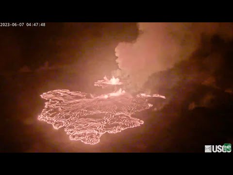
Aerial video of the Southwest Rift Zone eruption of Kīlauea
Aerial video of the Southwest Rift Zone eruption of Kīlauea, viewed during an overflight at approximately 6 a.m. on June 3, 2024. USGS video.
Aerial video of the Southwest Rift Zone eruption of Kīlauea, viewed during an overflight at approximately 6 a.m. on June 3, 2024. USGS video.
Audio

Lava lake activity from inside Halema`uma`u Crater
Sounds of lava lake activity within Kilauea Volcano's summit vent inside Halema`uma`u Crater on the afternoon of February 14, 2011. The continuous "crashing wave" noise is the sound of churning lava as gases are released from the lake surface, which is in nearly constant motion.
Sounds of lava lake activity within Kilauea Volcano's summit vent inside Halema`uma`u Crater on the afternoon of February 14, 2011. The continuous "crashing wave" noise is the sound of churning lava as gases are released from the lake surface, which is in nearly constant motion.

Dramatic Developments at Kilauea Volcano
Kilauea Volcano in Hawaii has experienced its first explosive eruption in more than 80 years and is now spewing noxious gas at 10 times the normal rate. John Eichelberger, head of the USGS Volcano Hazards Program, fills us in on the situation.
Kilauea Volcano in Hawaii has experienced its first explosive eruption in more than 80 years and is now spewing noxious gas at 10 times the normal rate. John Eichelberger, head of the USGS Volcano Hazards Program, fills us in on the situation.
Webcams
[S2cam] - View of Nāpau Crater on the East Rift Zone of Kīlauea, view is to the southwest
Live view of Nāpau Crater on the East Rift Zone of Kīlauea, view is to the southwest [S2cam].
Disclaimer
Live view of Nāpau Crater on the East Rift Zone of Kīlauea, view is to the southwest [S2cam].
Disclaimer

[KOcam] Live Image of upper East Rift Zone from Maunaulu
This image is from a temporary research camera positioned near Maunaulu, looking northwest toward the upper East Rift Zone of Kīlauea.
Disclaimer
This image is from a temporary research camera positioned near Maunaulu, looking northwest toward the upper East Rift Zone of Kīlauea.
Disclaimer
[MITDcam] Kīlauea upper Southwest Rift Zone
[MITDcam] Live view of Kīlauea's upper Southwest Rift Zone, looking northwest from a seismic station in the Kaʻū Desert.
[MITDcam] Live view of Kīlauea's upper Southwest Rift Zone, looking northwest from a seismic station in the Kaʻū Desert.

[B2cam] Halemaʻumaʻu crater from the east rim and down-dropped block
[B2cam] This image is from a research camera located on the down-dropped block in Kīlauea caldera and east rim of Halemaʻumaʻu crater within Hawaiʻi Volcanoes National Park. The camera is looking west towards Halemaʻumaʻu crater.
Disclaimer
[B2cam] This image is from a research camera located on the down-dropped block in Kīlauea caldera and east rim of Halemaʻumaʻu crater within Hawaiʻi Volcanoes National Park. The camera is looking west towards Halemaʻumaʻu crater.
Disclaimer
Kīlauea Volcano Live Stream - Halemaʻumaʻu crater
Live view of the eruption in Halemaʻumaʻu, from the northwest rim of the caldera, looking east [V1cam] on the USGS YouTube Channel.
- USGS Kīlauea Volcano
- USGS Hawaiian Volcano Observatory
- Kilauea webcams
Live view of the eruption in Halemaʻumaʻu, from the northwest rim of the caldera, looking east [V1cam] on the USGS YouTube Channel.
- USGS Kīlauea Volcano
- USGS Hawaiian Volcano Observatory
- Kilauea webcams

[V1] Kīlauea caldera views
Live view of Kīlauea caldera, from the northwest rim of the caldera [V1cam]. This camera is a pan-tilt-zoom model and the view may change depending on activity.
Disclaimer
Live view of Kīlauea caldera, from the northwest rim of the caldera [V1cam]. This camera is a pan-tilt-zoom model and the view may change depending on activity.
Disclaimer