


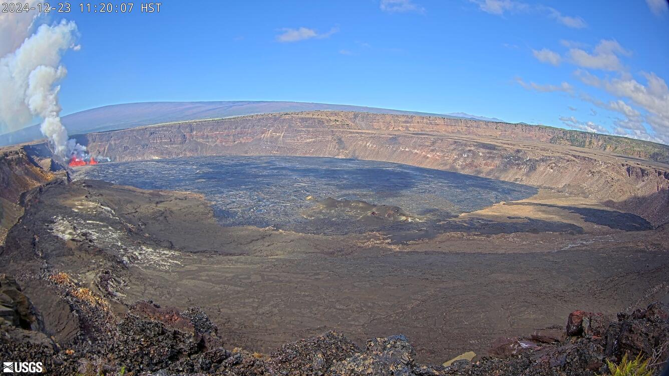
During an overflight at 2:30 p.m. HST today, December 23, USGS Hawaiian Volcano Observatory scientists were able to collect a molten sample of lava from the new eruption within Kaluapele. Kaluapele, the summit caldera of Kīlauea volcano, is the sacred home of the elemental force associated with volcanoes—Pele.
Is Tephra Falling?
Livestream views of the eruption
Read answers to Frequently-Asked-Questions about eruptions at the summit of Kīlauea
Eruptive activity at the summit of Kīlauea, within Hawaiʻi Volcanoes National Park, has been episodic since an eruption began on December 23, 2024.
Sources/Usage: Public Domain. View Media Details
Data Disclaimer: The information presented on this web page is intended for public information and awareness and is also used in real-time response messaging (https://volcanoes.usgs.gov/hans-public/search/). All data are unreviewed, preliminary estimates derived from rapid analyses. The data are subject to revision and are not suitable for research, quantitative analyses, or scientific publication. Complete datasets will be released after appropriate review as USGS data releases. Please consult the USGS Hawaiian Volcano Observatory at askHVO@usgs.gov with any questions about data or usage.
Kīlauea is in a unique phase of activity in Halemaʻumaʻu, with episodes of lava fountaining erupting from two vents (north and south) since the eruption began the night of December 23, 2024.
These spectacular lava fountains have been easily visible from many of the publicly accessible overlooks within Hawaiʻi Volcanoes National Park. Even so, hazards persist during volcanic activity for those visiting to enjoy the sights. Shifting winds blow around elevated concentrations of volcanic gases, particularly strong-smelling sulfur dioxide (SO2), and tephra (including Pele’s hair that are mostly comprised of volcanic glass). The gases and small glassy particles can irritate respiratory systems, and Pele’s hair can form splinters under the skin.
What characterizes an episode?
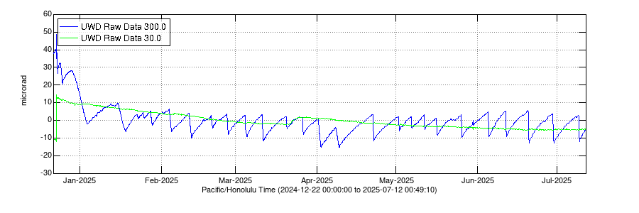
During the ongoing eruption, tiltmeters have shown inflationary tilt prior to a lava fountaining episode, as pressure builds beneath the surface, and a switch to deflationary tilt when a lava fountain episode begins, indicative of the pressure within the magma chambers being released. The switch to deflationary tilt generally defines an episode start, along with an increase in fountaining vigor.
The inflationary and deflationary ground deformation associated with every lava fountain episode creates a saw-tooth pattern in tilt records since the eruption began.
Electronic tilt at Kīlauea summit - since the eruption started in December 2024
Media
Remote image Url
Sources/Usage: Public Domain. View Media Details
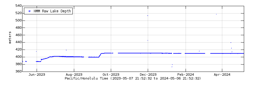
Laser rangefinder Halemaʻumaʻu crater floor elevation at Kīlauea summit - Past Year
Media
Remote image Url
Sources/Usage: Public Domain. View Media Details
Timeline of Eruptive Episodes
Data Disclaimer: The information presented in the table below is intended for public information and awareness and is also used in real-time response messaging (https://volcanoes.usgs.gov/hans-public/search/). All data are unreviewed, preliminary estimates derived from rapid analyses. The data are subject to revision and are not suitable for research, quantitative analyses, or scientific publication. Complete datasets will be released after appropriate review as USGS data releases. Please consult the USGS Hawaiian Volcano Observatory at askHVO@usgs.gov with any questions about data or usage.
All times in the table below are Hawaiian Standard Time (HST). Note that episodes 17 and earlier may include precursory activity in the duration (rather than just the fountaining activity). Episode durations and pauses are rounded to the nearest hour, half-hour, or day.
| Episode Number | Start Date/Time (HST) | Pause Date/Time (HST) | Eruptive Episode Duration | Pause Duration Following Episode | Approximate Maximum Fountain Height (meters) | Approximate volume of lava erupted (million cubic meters) | Notes |
| 1 | December 23, 2024 - 2:20 a.m. | December 23, 2024 - 4 p.m. | 14 hours | 16 hours | 158 | 9.3 | Fissures open, eruption focuses on north and south vents |
| 2 | December 24, 2024 - 8 a.m. | December 25, 2024 - 11 a.m. | 27 hours | 21 hours | 95 | 4.7 | Several vents reactivate |
| 3 | December 26, 2024 - 8 a.m. | January 3, 2025 - 8:30 p.m. | 8.5 days | 12 days | 86 | 13.0 | Several vents reactivate, activity focuses at north and south vents |
| 4 | January 15, 2025 - 9 a.m. | January 18, 2025 - 10:10 a.m. | 3 days | 4 days | 95 | 6.5 | North and south vents active |
| 5 | January 22, 2025 - 2:30 p.m. | January 23, 2025 - 4:30 a.m. | 14 hours | 2 days | 41 | 1.0 | North vent active only |
| 6 | January 24, 2025 - 11:28 p.m. | January 25, 2025 - 12:36 p.m. | 13 hours | 2 days | 70 | 1.1 | North vent active only |
| 7 | January 27, 2025 - 6:41 p.m. | January 28, 2025 - 10:41 a.m. | 16 hours | 6 days | 89 | 2.9 | North and south vents active |
| 8 | February 3, 2025 - 9:52 p.m. | February 4, 2025 - 7:23 p.m. | 22 hours | 7 days | 114 | 4.6 | North and south vents active |
| 9 | February 11, 2025 - 10:16 a.m. | February 12, 2025 - 8:43 a.m. | 22 hours | 7 days | 135 | 5.2 | North and south vents active |
| 10 | February 19, 2025 - 8:22 p.m. | February 20, 2025 - 9:18 a.m. | 13 hours | 5 days | 146 | 2.5 | North vent active only |
| 11 | February 25, 2025 - 6:26 p.m. | February 26, 2025 - 7:06 a.m. | 13 hours | 6 days | 157 | 4.0 | North and south vents active |
| 12 | March 4, 2025 - 7:30 a.m. | March 5, 2025 - 10:37 a.m. | 27 hours | 6 days | 176 | 4.4 | North and south vents active |
| 13 | March 11, 2025 - 2:36 a.m. | March 11, 2025 - 3:13 p.m. | 13 hours | 8 days | 215 | 5.5 | North and south vents active |
| 14 | March 19, 2025 - 9:26 a.m. | March 20, 2025 - 1:49 p.m. | 28 hours | 5 days | 225 | 2.4 | North and south vents active |
| 15 | March 25, 2025 - 12:04 p.m. | March 26, 2025 - 7:10 p.m. | 31 hours | 5 days | 322 | 3.6 | North and south vents active; south vent inclined |
| 16 | March 31, 2025 - 10:57 p.m. | April 2, 2025 - 12:04 p.m. | 37 hours | 5 days | 326 | 6.0 | North and south vents active, south vent dominant |
| 17 | April 7, 2025 - 10:15 p.m. | April 9, 2025 - 9:45 a.m. | 35.5 hours | 13 days | 73 | 3.9 | North and south vents active |
| 18 | April 22, 2025 - 3:30 a.m. | April 22, 2025 - 1:28 p.m. | 10 hours | 9 days | 266 | 5.2 | Precursory low-level activity began on April 16, 2025 - 10:01 p.m.; north and south vents active, south vent dominant |
| 19 | May 1, 2025 - 9:28 p.m. | May 2, 2025 - 5:20 a.m. | 8 hours | 5 days | 126 | 2.8 | Precursory low-level activity began on May 1, 2025 - 11:49 a.m.; north vent active only |
| 20 | May 6, 2025 - 5:28 p.m. | May 6, 2025 - 9:28 p.m. | 4 hours | 5 days | 153 | 2.4 | Precursory low-level activity began on May 5, 2025 - 10:48 a.m.; north and south vents active, north vent dominant |
| 21 | May 11, 2025 - 12:45 p.m. | May 11, 2025 - 8:36 p.m. | 8 hours | 4 days | 217 | 3.1 | North vent primarily active |
| 22 | May 16, 2025 - 5:13 a.m. | May 16, 2025 - 3:29 p.m. | 10 hours | 9 days | 276 | 3.6 | North vent active only |
| 23 | May 25, 2025 - 4:15 p.m. | May 25, 2025 - 10:25 p.m. | 6 hours | 10 days | 345 | 4.6 | North and south vents active, north vent dominant |
| 24 | June 4, 2025 - 8:55 p.m. | June 5, 2025 - 4:28 a.m. | 7.5 hours | 6 days | 364 | 5.0 | North and south vents active, north vent dominant |
| 25 | June 11, 2025 - 11:57 a.m. | June 11, 2025 - 8:08 p.m. | 8 hours | 8 days | 350 | 5.3 | North and south vents active, north vent dominant |
| 26 | June 20, 2025 - 1:40 a.m. | June 20, 2025 - 10:25 a.m. | 9 hours | 9 days | 371 | 6.6 | North and south vents active, north vent dominant |
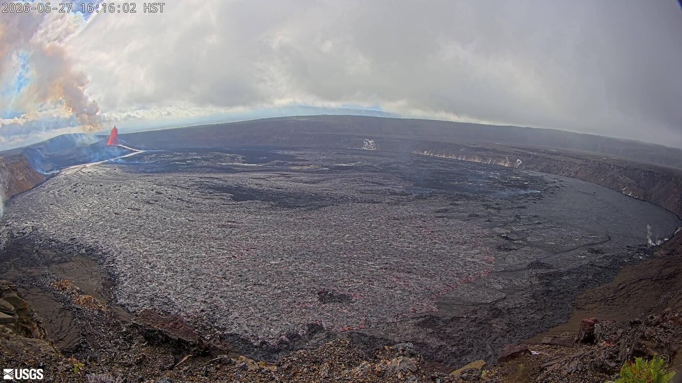
| 27 | June 29, 2025 - 9:05 a.m. | June 29, 2025 - 7:54 p.m. | 11 hours | 8 days | 332 | 5.9 | North and south vents active, north vent dominant |
| 28 | July 9, 2025 - 4:10 a.m. | July 9 - 1:20 p.m. | 9 hours | 11 days | 321 | 5.2 | Only north vent active |
| 29 | July 20, 2025 - 5:15 a.m. | July 20 - 6:35 p.m. | 13 hours | 16 days | 63 | 6.7 | North and south vents active, north vent dominant |
| 30 | August 6, 2025 - 1:20 a.m. | August 6, 2025 - 12:55 p.m. | 12 hours | 16 days | 52 | 7.9 | North and south vents active, north vent dominant; new vent in southwest wall |
| 31 | August 22, 2025 - 2:04 p.m. | August 23, 2025 - 2:52 a.m. | 13 hours | 10 days | 88 | 7.6 | North and south vents active; north vent dominant and inclined. Intermediate vents also active |
| 32 | September 2, 2025 - 6:35 a.m. | September 2, 2025 - 8:01 p.m. | 12 hours | 16 days | 101 | 9.0 | North, south, and intermediate vents active; north vent inclined |
| 33 | September 19, 2025 - 3:11 a.m. | September 19, 2025 - 12:08 p.m. | 9 hours | 12 days | 249 | 5.7 | North and south vents active; north vent inclined |
| 34 | October 1, 2025 - 12:53 a.m. | October 1, 2025 - 7:03 a.m. | 6 hours | 17 days | 383 | 9.0 | North and south vents active; north vent inclined |
| 35 | October 17, 2025 - 8:05 p.m. | October 18, 2025 - 3:32 a.m. | 7 hours | 22 days | 479 | 10.2 | North and south vents active; north vent inclined |
| 36 | November 9, 2025 - 11:15 a.m. | November 9, 2025 - 4:16 p.m. | 5 hours | 16 days | 386 | 8.1 | North and south vents active, as well as small vent area south of south vent; north vent inclined |
| 37 | November 25, 2025 - 2:30 p.m. | November 25, 2025 - 11:39 p.m. | 9 hours | 10 days | 174 | 6.0 | Fountains active at north vent active only; lava visible in south vent |
| 38 | December 6, 2025 - 8:45 a.m. | December 6, 2025 - 8:52 p.m. | 12 hours | 17 days | 384 | 12.1 | North and south vents active; south vent dominant and inclined fountain |
| 39 | December 23, 2025 - 8:10 p.m. | December 24, 2025 - 2:13 a.m. | 6 hours | 19 days | 407 | 9.3 | North and south vents active |
| 40 | January 12, 2026 - 8:22 a.m. | January 12, 2026 - 6:04 p.m. | 10 hours | 12 days | 250 | 5.5 | North and south vents active; north vent dominant |
| 41 | January 24, 2026 - 11:10 a.m. | January 24, 2026 - 7:29 p.m. | 8 hours | 22 days | 450 | 10.6 | North and south vents active |
| 42 | February 15, 2026 - 1:50 p.m. | February 15, 2026 - 11:38 p.m. | 10 hours | 22 days | 400 (may update) | 11.6 | North and south vents active, small intermediate fountain |
| 43 | March 10, 2026 - 9:17 a.m. | March 10, 2026 - 6:21 p.m. | 9 hours | 30 days | 540 | 11.9 | North and south vents active, small intermediate fountain |
| 44 | April 9, 2026 - 11:10 a.m. | April 9, 2026 - 7:41 p.m. | 8.5 hours | 13 days | 240 | 5.8 | North vent erupted fountain, though most precursory lava flows erupted from the south vent; small eq swarm and deformation on south rim |
| 45 | April 23, 2026 - 1:34 a.m. | April 23, 2026 - 10:01 a.m. | 8.5 hours | 12 days | 265 | 5.2 | North vent erupted lava fountain; precursory lava flows from both vents |
| 46 | May 5, 2026 - 8:17 a.m. | May 5, 2026 - 5:22 p.m. | 9 hours | 9 days | 200 | 4.6 | North vent erupted lava fountain; precursory lava flows from both vents |
| 47 | May 14, 2026 - 3:27 p.m. | May 15, 2026 - 12:27 a.m. | 9 hours | 17 days | 200 | 5.2 | North vent erupted lava fountain; precursory lava flows exclusively from the south vent. |
| 48 | June 1, 2026 - 4:40 a.m. | June 1, 2026 - 1:37 p.m. | 9 hours | 13 days | 200 | 5.7 | North vent erupted lava fountain; precursory lava flows exclusively from the south vent. Small eq swarm and deformation on south rim. |
| 49 | June 14, 2026 - 9:36 a.m. | June 14, 2026 - 5:05 p.m. | 7.5 hours | 13 days | 210 | 5 | Precursory lava flows from the north and south vents; north vent erupted lava fountain. |
| 50 | June 27, 2026 - 10:10 a.m. | June 27, 2026 - 5:10 p.m. | 7 hours | 18 days | 300 | 4.9 | Precursory lava flows from the north vent; north vent erupted lava fountain. |
| 51 | July 15, 2026 - 8:30 a.m. | July 15, 2026 - 4:46 p.m. | 8 hours | 13 days | 290 | 5.1 | Precursory lava flows from the north and south vents; north vent erupted lava fountain. |
| 52 | July 28, 2026 - 7:10 p.m. | July 29, 2026 - 2:36 a.m. | 7 hours | TBD | 150 | 4.7 | Precursory lava flows from the north vent; north vent erupted lava fountain. |
Latest eruption maps
Media
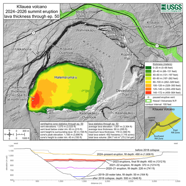
This map shows thickness values for lava flows within Halema‘uma‘u crater from the Kīlauea summit eruption that began on December 23, 2024. These values were calculated by topographic differencing between a digital elevation model collected on June 30, 2026—after eruptive episode 50—and one from before the eruption began. Also included here are west-to-east profiles across the summit caldera, depicting topographic changes since 2018. Profiles are provided for the periods before the 2018 caldera collapse, shortly after the 2018 collapse, following each of the five summit eruptions from 2020–2023, and for this eruption following the end of episode 50. Also shown is the maximum depth of the 2019–2020 Halema‘uma‘u water lake. Eruptive vent and tephra cone statistics through episode 50: Vent elevations: 1,075 meters (3,525 feet) Vent level below crater rim: 65 meters (215 feet) Vent height to surrounding lava: 50 meters (165 feet) Cone's peak elevation: 1,185 meters (3,890 feet) Cone's height to crater rim: 45 meters (150 feet) Lava statistics through episode 50: Average lava elevation: 1,007 meters (3,304 feet) Average lava thickness: 90 meters (295 feet) Maximum lava thickness: 170 meters (560 feet) Total lava extent: 452 hectares (1,116 acres) Total lava volume: 284.7 million cubic meters (75.2 billion gallons)
Sources/Usage: Public Domain. View Media Details
Media
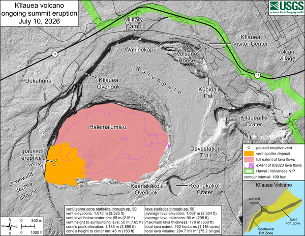
This reference map depicts the Kīlauea summit eruption within Halema‘uma‘u crater that began on December 23, 2024. Most of the data for this map were collected during a USGS Hawaiian Volcano Observatory helicopter overflight on June 30, 2026, so the provided statistics are reflective of the entire eruption through episode 50 on June 27. Eruptive vent and tephra cone statistics through episode 50: Vent elevations: 1,075 meters (3,525 feet) Vent level below crater rim: 65 meters (215 feet) Vent height to surrounding lava: 50 meters (165 feet) Cone's peak elevation: 1,185 meters (3,890 feet) Cone's height to crater rim: 45 meters (150 feet) Lava statistics through episode 50: Average lava elevation: 1,007 meters (3,304 feet) Average lava thickness: 90 meters (295 feet) Maximum lava thickness: 170 meters (560 feet) Total lava extent: 452 hectares (1,116 acres) Total lava volume: 284.7 million cubic meters (75.2 billion gallons).
Sources/Usage: Public Domain. View Media Details
Media
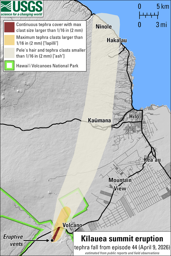
This map shows the tephra fall associated with episode 44 of Kīlauea's episodic summit eruption, on April 9, 2026. Tephra is a generic word for any material erupted by a volcano that travels through the air before landing on the ground. Most tephra fall from past lava fountaining episodes has landed in the closed area of Hawaiʻi Volcanoes National Park, southwest of the eruptive vents, with several instances of tephra fall documented in other communities on the island. During episode 44 on April 9, lava fountains from the north vent in Halemaʻumaʻu at the summit of Kīlauea reached up at 240 m (800 feet). Southerly winds blowing to the north-northeast resulted in tephra fall in a narrow corridor within Hawaiʻi Volcanoes National Park, on Highway 11, and on communities to the northeast within the Districts of Kaʻū, Puna, South Hilo, and North Hilo.This map shows the tephra fall associated with episode 44 of Kīlauea's episodic summit eruption, on April 9, 2026. Tephra is a generic word for any material erupted by a volcano that travels through the air before landing on the ground. Most tephra fall from past lava fountaining episodes has landed in the closed area of Hawaiʻi Volcanoes National Park, southwest of the eruptive vents, with several instances of tephra fall documented in other communities on the island. During episode 44 on April 9, lava fountains from the north vent in Halemaʻumaʻu at the summit of Kīlauea reached up at 240 m (800 feet). Southerly winds blowing to the north-northeast resulted in tephra fall in a narrow corridor within Hawaiʻi Volcanoes National Park, on Highway 11, and on communities to the northeast within the Districts of Kaʻū, Puna, South Hilo, and North Hilo.
Sources/Usage: Public Domain. View Media Details
Media
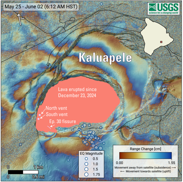
COSMO-SkyMed Second Generation (CSG) interferogram for the period from May 25 to June 2, 2026, covering Kīlauea volcano’s summit region. Each color fringe represents 1.55 centimeters (0.61 inches) of ground movement in the direction between the satellite and the ground (range change). The symbol in the upper left indicates the satellite's orbit direction (arrow) and look direction (bar). Earthquakes are marked with circles with the size proportional to their magnitude. The lava flows covering the crater floor are represented by the pink polygon, the two vents (circles) and the Episode 30 fissure (line) are marked in light pink. As episode 48 of lava fountaining in Halemaʻumaʻu at Kīlauea summit was ending on June 1, 2026, 53 earthquakes, most smaller than magnitude-2, occurred at depths up to 1 mile (1.5 km) below the ground surface beneath the south rim of Halema'uma'u crater. An area along the south rim of Halemaʻumaʻu also rose by several inches (centimeters). The specific cause of that uplift remains uncertain but it could be related to magma movement.
Sources/Usage: Public Domain. View Media Details
Media
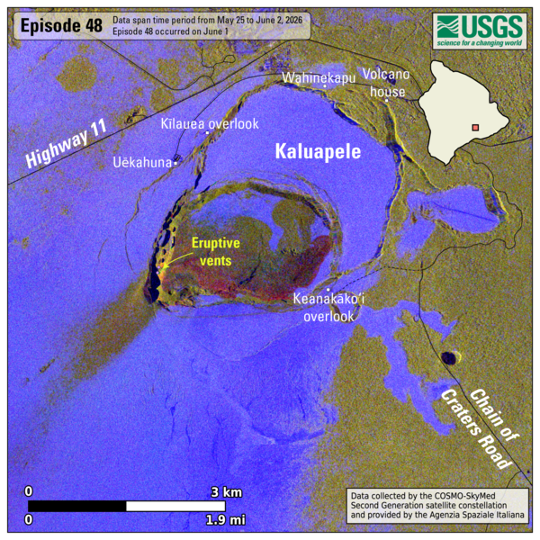
This map shows lava flow and tephra accumulation at the summit of Kīlauea volcano associated with episode 48 of the ongoing eruption in Halemaʻumaʻu that started on December 23, 2024, using data recorded by the Italian Space Agency's (ASI) COSMO-SkyMed Second Generation satellite constellation. These maps combine cross-polarized radar amplitude images taken on two different dates (on May 25 and June 2, 2026), along with interferometric coherence from the time between those dates. In the maps, unchanged barren areas are represented in blue/purple, vegetated areas appear in yellow/light green, new deposits over barren land are shown in dark green, and the recent lava flows in red. Public viewing areas within Hawaiʻi Volcanoes National Park are indicated with white squares; these can be temporarily closed for public safety.
Sources/Usage: Public Domain. View Media Details
Media
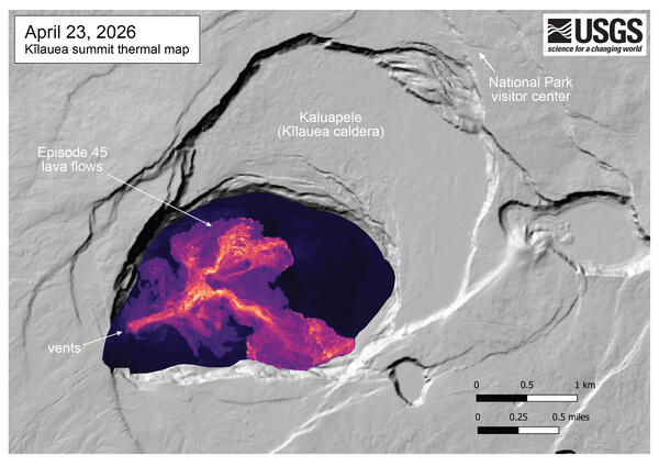
This thermal map was made from thermal images collected during an overflight immediately after the end of Kīlauea summit episode 45 lava fountaining on April 23, 2026. The thermal map shows a single channelized lava flow extending from the north vent, splitting into branching lava channels in the central part of the crater floor. Individual lobes of lava then extend out to the northeast and southeast, into the eastern portion of the Halema‘uma‘u crater.
Sources/Usage: Public Domain. View Media Details
Hazards Associated with the Ongoing Eruption
Lava Fountains and Tephrafall
Lava fountains during eruptive episodes have reached up to 1570 feet (479 meters) above the vents. Material from the lava fountains, called tephra, is deposited near the vents and finer particles can be transported downwind.
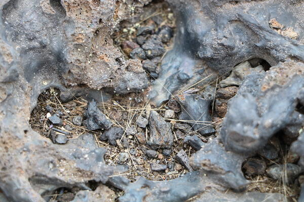
Tephra is a word for any volcanic material that is erupted and travels through the air before landing on the ground. Tephra includes very small particles, such as volcanic ash, as well as light and frothy rocks full of holes called reticulite, more robust rocks like scoria, larger pieces called bombs, and ever-present strands of volcanic glass known as Pele’s Hair.
Most of the tephra has been deposited southwest of the active vents, in a closed area of Hawaiʻi Volcanoes National Park, A mound of tephra over 150 feet (45 meters) high has grown on the crater rim, and a blanket of tephra extends over a mile (2 km) to the southwest. Occasionally, tephra can fall on populated areas nearby or downwind.
Residents and visitors should minimize exposure to Pele's hair and other glassy volcanic fragments, which can cause skin and eye irritation and can also contaminate catchment water supplies. More information about how Pele's hair, its hazards, and what to do is available here. A recently updated Frequently Asked Questions document that includes information about potential health effects of Pele's hair is available here: https://vog.ivhhn.org/sites/default/files/PelesHair_FAQs_v2.pdf
Lava flows have been confined to the floor of Halemaʻumaʻu crater within Kaluapele (Kīlauea summit caldera). This area of Hawaiʻi Volcanoes National Park is closed to the public.
Types of Tephra
Media
Strands of Pele's Hair collect in low-lying areas near Keanakākoʻi Overlook in Hawaiʻi Volcanoes National Park. USGS photo by K. Mulliken.
Sources/Usage: Public Domain. View Media Details
Media
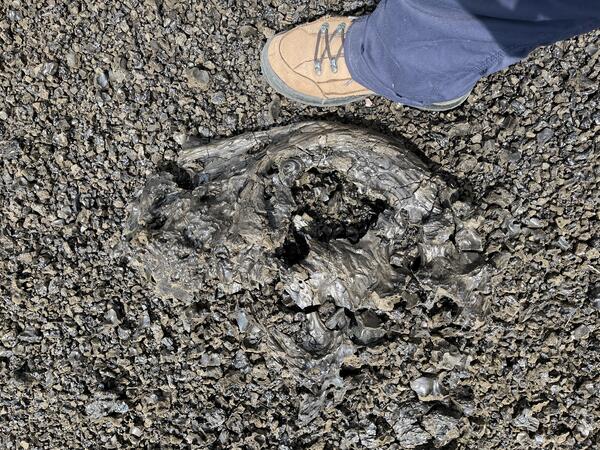
Episode 23 of the ongoing Kīlauea summit eruption in Halema‘uma‘u began with high fountains that deposited tephra outside the caldera to the southwest. Material was still molten as it fell on the landscape, evidenced by the fluid textures shown here. This clast, large enough to be called a volcanic bomb, is over 50 cm (almost two feet) long. USGS photo by K. Lynn.
Sources/Usage: Public Domain. View Media Details
Media
A close-up view looking at one of the more vesicular pieces of tephra from a recent fountaining episode at Kīlauea summit. When the gas-rich lava erupting from the vents quickly cools, it solidifies with this light and frothy texture. The bubble walls are so thin that the color of this tephra is more golden brown. USGS photo taken by L. DeSmither on May 29, 2025.
Sources/Usage: Public Domain. View Media Details
Volcanic Gas Emissions
Large amounts of volcanic gas—primarily water vapor (H2O), carbon dioxide (CO2), and sulfur dioxide (SO2)—are released during lava fountaining episodes at the summit of the Kīlauea. Episodes in the ongoing eruption have produced emission rates up to 75,000 tonnes per day of SO2. It’s likely that sulfur dioxide emission rates have been even higher during some eruptive episodes, though measurements have not been possible. When the lava fountains are not active, SO2 emission rates are decreased and in the range of 1,200 to 1,500 tonnes per day.
The plume of volcanic gas and fine tephra particles rising from the vents has reached more than 20,000 feet (6,000 m) above ground level and is transported by the wind. SO2 reacts in the atmosphere with oxygen, sunlight, moisture, and other gases and particles, and within hours to days, converts to fine particles. The particles scatter sunlight and cause the visible haze that is observed downwind of Kīlauea, known as vog (volcanic smog). Vog creates the potential for airborne health hazards to residents and visitors, damages agricultural crops and other plants, and affects livestock operations.
Further information on vog can be found at https://vog.ivhhn.org/
Wind Conditions Affect Distribution of VOG and Tephra Fall
Media
Sources/Usage: Public Domain. View Media Details
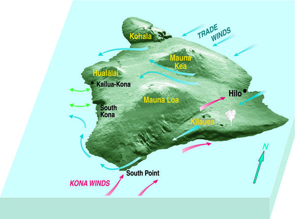
In Hawaii, trade winds refer to the predominant condition of winds that flow from the northeast to the southwest. Where rising warm air from the Earthʻs surface meets the trade winds, an inversion layer exists between 5,000-10,000 feet (1,500-3,000 m) elevation. The inversion inhibits air below from rising above the summits of Mauna Kea and Mauna Loa and causes air to flow around the mountains.
Eruptive plumes at the summit of Kīlauea can rise vertically and be sheared to the southwest where they encounter the trade wind inversion. During trade wind conditions, most volcanic gas and tephra is transported to the southwest. Larger tephra particles fall on the ground within 1-3 miles (1-5 kilometers) of the eruptive vent(s), with the highest concentrations immediately downwind of the vent(s) in the closed area of Hawaiʻi Volcanoes National Park. Light particles, including Pele's hair, can be transported greater distances, 10 miles (15 kilometers) from the vent downwind.
During less common Kona wind conditions, material from Kīlauea summit eruptive plumes may be transported north/west. Slack wind conditions allow eruptive plumes at the summit of Kīlauea to rise buoyantly and billow outwards.
The subtropical jet stream can be at elevations above 10,000 feet (3,000 m) and consist of generally faster winds travelling from west/northwest to east/southeast. The volcanic plumes during the ongoing Kīlauea summit eruption have not encountered the subtropical jet stream.
How to Stay Aware of Eruptive Activity and Hazards
- Read the latest Kīlauea - Volcano Update for information on the status of the eruption
- Check the Hawaiʻi Volcanoes National Park website for information about viewing and closures
- Follow official guidelines; information on potential impacts will come from the Hawaii County Civil Defense Agency
Impacts of Recent Eruptive Episodes
Several lava fountaining episodes have resulted in tephra fall on visitor areas of Hawaiʻi Volcanoes National Park, Highway 11 north of the vents, and neighboring communities. Where tephra falls is dependent on the eruptive episode (how high the lava fountains reach) and wind conditions (where the wind is blowing and how strongly).
Data Disclaimer: The information presented in the table below is intended for public information and awareness and is also used in real-time response messaging (https://volcanoes.usgs.gov/hans-public/search/). All data are unreviewed, preliminary estimates derived from rapid analyses. The data are subject to revision and are not suitable for research, quantitative analyses, or scientific publication. Complete datasets will be released after appropriate review as USGS data releases. Please consult the USGS Hawaiian Volcano Observatory at askHVO@usgs.gov with any questions about data or usage.
| Episode | Date | Fountain Height above vent level | Wind Conditions | Plume Height above ground level unless otherwise noted | Impacts |
| 4 | January 15 - 18, 2025 | 330 feet/100 meters | No/light | Pele’s Hair fell in HAVO, Volcano Golf Course, Volcano Village, Mauna Loa Estates, and Ohia Estates. In some areas, the hair tangled into tumble-weed like structures up to 60 cm (about two feet) long. | |
| 15 | March 26, 2024 | 1070 feet/325 meters | No/light | Tephrafall on Uēkahuna overlook in HAVO (cm-sized); Pele’s Hair fell on Volcano Golf Course and neighboring communities; HVO’s KWcam, F1cam, laser rangefinder power system damaged | |
| 16 | March 31 – April 2, 2025 | 1070 feet/325 meters | No/light | 10,000 feet/3000 meters | Tephra up to about an inch (a couple cm) fell on Highway 11 between mile markers 32 and 33; minor Pele’s Hair fell on Volcano Golf Course; minor brushfire in area northwest of vents on crater rim in closed area of HAVO |
| 23 | May 25, 2025 | 1150 feet/350 meters | Trades (from NE) | at least 5,000 feet/1500 meters | Peleʻs Hair reported in Pāhala |
| 28 | July 9, 2025 | 1050 feet/320 meters | Trades (from NE) | 15,000 feet/4500 meters | Peleʻs Hair reported in Captain Cook and Miloliʻi and on Highway 11 |
| 31 | August 22-23, 2025 | 328 feet/100 meters | Trades (from NE) | 10,000 feet/3000 meters | Pele's Hair deposition was reported in Pāhala |
| 34 | October 1, 2025 | 1230 feet/375 meters | Trades (from NE) | More than 15,000 feet/4500 meters | Fine particles (no larger strands) reported in Ocean View |
| 35 | October 17-18, 2025 | 1480 feet/450 meters | Northerly | More than 20,000 feet/6000 meters | Fist-sized clasts along Hwy 11 between Volcano and Pāhala (nothing reported in Pāhala). Fine ash particles reported in Ocean View. Damage to monitoring solar panels and heat damage to cameras |
| 36 | November 9, 2025 | 1230 feet/375 meters | Trades (from NE) | 10,000 feet/3000 meters | Ash fall reported in Waiʻōhinu; Pele's hair in Pāhala |
| 38 | December 6, 2025 | 1259 feet/384 meters | Trades (from NE) | More than 20,000 feet/6000 meters | Ash fall, Pele's Hair, and limu-o-Pele like material in Pāhala. Ashfall in Waiohinu/Nāʻālehu. Leser amounts of ash fall in Ocean View. |
| 41 | January 24, 2026 | 1475 feet/450 meters | Weak surface level, east/northeasterly winds at high levels | More than 20,000 feet/6000 meters | Tephra fallout densest within 5 miles (8 kilometers) east-northeast of the vents, covering parts of Hawaiʻi Volcanoes National Park and neighboring communities (Volcano Village, Mauna Loa estates, Ohia Estates). Farther away, parts of the Volcano Golf Course Community, Ohia Estates, Royal Hawaiian Estates, and Fern Forest received tephra fall ranging from Pele’s hair and ash to pieces of reticulite that were up to several inches (64 mm) in diameter. Communities even farther away, in the District of Puna and parts of South Hilo, saw light fall or a dusting of fine-grained ash and Pele’s hair, extending from Pepeekeo to Kalapana. NWS issued an ashfall advisory, followed by an ashfall warning. |
| 42 | February 15, 2026 | 1310 feet (400 meters) | Trades (from NE) at ground level, east/northeasterly winds at high levels | 35,000 feet/10,670 meters above sea level (NWS) | Ash reported in Pāhala, Nāʻālehu, Waiʻōhinu, Ocean View. Pele's hair in Pāhala. |
| 43 | March 10, 2026 | 1310 feet (400 meters) | Light and variable ground-level winds, with winds about the inversion level (8,000 to10,000 feet ASML) light from the southwest | 25,000 feet/7,6200 meters above sea level (NWS) | Tephra fallout densest north-northeast of the vents, with continuous coverage at Uēkahuna overlook and Kilauea Military Camp in Hawaiʻi Volcanoes National Park, and Highway 11 nearby and parts of Volcano Golf Course and Volcano Village. Parts of Volcano Golf Course and Volcano Village farther from the vents, and neighboring communities of Mauna Loa estates, Ohia Estates and Royal Hawaiian Estates received less continuous fallout ranging from Pele’s hair and ash to pieces of reticulite that were up to several inches in diameter. Communities even farther away, in the District of Puna and parts of South Hilo, saw light fall or a dusting of fine-grained ash and Pele’s hair, extending to as far at Laupahoehoe to the north. NWS issued an ashfall advisory, followed by an ashfall warning. |
| 44 | April 9, 2026 | 800 feet (240 meters) | Strong southerly winds | 16,000 feet/4,900 meters above sea level (VAAC) | Tephra fell outside of the closed area of Hawaiʻi Volcanoes National Park along the north rim of Kaluapele (Kīlauea caldera) and in adjacent communities. Tephra fall was most dense in the area surrounding Kilauea Military Camp. Tephra as large as 10 inches (25 centimeters) was reported in the Volcano Golf Course subdivision, and fine ash and Pele's hair was reported as far away as Hilo and Nīnole. NWS issued an ashfall warning. |
| 45 | April 23, 2026 | 860 feet (260 meters) | Trades (from NE) | 15,000 feet/4,500 meters above sea level (VAAC) | No significant tephra fallout was reported at visitor areas of Hawaiʻi Volcanoes National Park or on county roads. Winds blew the plume to the south at low altitudes and to the southwest at higher altitudes, with minor amounts of ash fall reported in the community of Pāhala located about 20 miles (32 kilometers) to the southwest of the eruptive vents in Halemaʻumaʻu. NWS issued an ashfall advisory. |
| 46 | May 5, 2026 | 650 feet (200 meters) | Southeasterly (lower level) southwesterly (upper level) | 20,000 feet/6,000 meters above sea level (VAAC) | Fist-sized and smaller tephra fell outside of the closed area of Hawaiʻi Volcanoes National Park along the north rim of Kaluapele (Kīlauea caldera) and on Highway 11 between mile markers 31 and 32. Uēkahuna and Kīlauea overlooks temporarily closed. Pele's hair reported in Volcano Golf Course subdivision. NWS issued an ashfall advisory. |
| 47 | May 14, 2026 | 650 feet (200 meters) | Lower level trades (from NE); upper lever westerly | 20,000 feet/6,000 meters above sea level (VAAC) | Most tephra fell within the closed area of Hawaiʻi Volcanoes National Park, but sparse reticulite up to 3 inches (5 centimeters) in size fell at both the Uēkahuna and Keanakākoʻi overlooks in Hawaiʻi Volcanoes National Park. Fine ash and Peleʻs hair fell outside Hawaiʻi Volcanoes National Park in communities to the northeast, including Mauna Loa Estates, ʻŌhiʻa Estates, Volcano village, and Royal Hawaiian Estates. NWS did not issue an ashfall advisory. |
| 48 | June 1, 2026 | 650 feet (200 meters) | Lower level trades (from NE); upper lever westerly | 24,000 feet/7,300 meters above sea level (VAAC) | Most tephra fell within the closed area of Hawaiʻi Volcanoes National Park, but sparse reticulite up to 1 inch (2 centimeters) in size fell at both the Uēkahuna overlook and on Highway 11 west of Nāmakanipaio campground. Fine ash and Pele's hair was reported from Hawaiʻi Volcanoes National Park in communities to the northeast, including Mauna Loa Estates, Ohia Estates, Volcano village, and Royal Hawaiian Estates. Three flights departing/arriving at Hilo International Airport were cancelled. |
Additional Information
- Search for past volcano updates
- Subscribe to the USGS Volcano Notification Service to receive eruption updates
- Kīlauea geology and history
- Kīlauea Maps
- Vog Information Dashboard
- General Hawai‘i County Civil Defense information or subscribe to CD alerts and updates
- Follow USGS Volcanoes on Twitter, Facebook, and Instagram.
- Volcano viewing information from Hawaii Volcanoes National Park
Recent eruptions have taken place within Hawai‘i Volcanoes National Park. Please visit the Park website to learn more about their operations.

December 23, 2024 - Kīlauea summit eruption
This video, taken from the west rim of Kaluapele (Kīlauea caldera), in the closed area of Hawaiʻi Volcanoes National Park, shows the new eruption that started this morning at 2:20 a.m. HST. At approximately 4:30 a.m. HST, the lava fountains were reaching up to 80 meters (260 feet) and by 5:30 a.m., lava covered an area of approximately 400 acres on the caldera floor. USGS video by D. Downs.
Filter Total Items: 71

December 23, 2024 - Collecting a lava sample
During an overflight at 2:30 p.m. HST today, December 23, USGS Hawaiian Volcano Observatory scientists were able to collect a molten sample of lava from the new eruption within Kaluapele. Kaluapele, the summit caldera of Kīlauea volcano, is the sacred home of the elemental force associated with volcanoes—Pele.

December 23, 2024 - Preparing Kīlauea's newest eruption samples
December 23, 2024 - Preparing Kīlauea's newest eruption samplesKīlauea's newest eruption samples contain olivine - a common green mineral in Hawaiian lavas. USGS Hawaiian Volcano Observatory and University of Hawai‘i at Hilo staff are picking out the olivine crystals like this one, shown using a microscope to magnify it (the crystal is 1 mm in size, or about 0.04 inches across), to analyze their chemistry.

December 23, 2024 - Analyzing Kīlauea's recent eruption samples
December 23, 2024 - Analyzing Kīlauea's recent eruption samplesAfter sample preparation, University of Hawai‘i at Hilo faculty and an undergraduate research student load the most recent Kīlauea eruption sample into the ED-XRF (energy dispersive x-ray fluorescence) for chemical analysis. Within 6 hours of sample collection, the chemical analysis of the lava was completed. USGS photo by K. Lynn.

December 23, 2024—Kīlauea summit eruption reference map
December 23, 2024—Kīlauea summit eruption reference mapThis reference map depicts the new Kīlauea summit eruption within Halema‘uma‘u crater on December 23, 2024, constructed using data captured during a USGS Hawaiian Volcano Observatory helicopter overflight at 9:30 a.m.

December 23, 2024 — Thermal map of eruption at Kīlauea summit
December 23, 2024 — Thermal map of eruption at Kīlauea summitThis thermal map shows lava flows covering the floor of Halemaʻumaʻu crater at the summit of Kīlauea. Fountaining was active in the southwest portion of the caldera, with flows extending east onto the downdropped block. Cooler colors (purple, black) show lower temperatures while hotter colors (orange, yellow) show higher temperatures. USGS map by M.

December 23, 2024 - New eruption in Kīlauea summit caldera
December 23, 2024 - New eruption in Kīlauea summit calderaKīlauea volcano began erupting within the summit caldera at approximately 2:20 a.m. HST this morning, December 23, 2024, following an increase in seismicity that began beneath the summit just a half hour earlier, at approximately 2:00 a.m. HST.

December 23, 2024 - View of the new eruption at the summit of Kīlauea
December 23, 2024 - View of the new eruption at the summit of KīlaueaThis photograph, taken at approximately 4:00 a.m. HST from the Volcano House overlook in Hawaiʻi Volcanoes National Park, shows the new eruption within Kaluapele (the summit caldera).

December 23, 2024 - View from the west rim of Kaluapele
December 23, 2024 - View from the west rim of KaluapeleFrom the closed area of Hawaiʻi Volcanoes National Park, USGS Hawaiian Volcano Observatory geologists documented the new eruption within Kalupele that started this morning at 2:20 a.m. HST.
Eruptive activity at the summit of Kīlauea, within Hawaiʻi Volcanoes National Park, has been episodic since an eruption began on December 23, 2024.
Sources/Usage: Public Domain. View Media Details
Data Disclaimer: The information presented on this web page is intended for public information and awareness and is also used in real-time response messaging (https://volcanoes.usgs.gov/hans-public/search/). All data are unreviewed, preliminary estimates derived from rapid analyses. The data are subject to revision and are not suitable for research, quantitative analyses, or scientific publication. Complete datasets will be released after appropriate review as USGS data releases. Please consult the USGS Hawaiian Volcano Observatory at askHVO@usgs.gov with any questions about data or usage.
Kīlauea is in a unique phase of activity in Halemaʻumaʻu, with episodes of lava fountaining erupting from two vents (north and south) since the eruption began the night of December 23, 2024.
These spectacular lava fountains have been easily visible from many of the publicly accessible overlooks within Hawaiʻi Volcanoes National Park. Even so, hazards persist during volcanic activity for those visiting to enjoy the sights. Shifting winds blow around elevated concentrations of volcanic gases, particularly strong-smelling sulfur dioxide (SO2), and tephra (including Pele’s hair that are mostly comprised of volcanic glass). The gases and small glassy particles can irritate respiratory systems, and Pele’s hair can form splinters under the skin.
What characterizes an episode?
During the ongoing eruption, tiltmeters have shown inflationary tilt prior to a lava fountaining episode, as pressure builds beneath the surface, and a switch to deflationary tilt when a lava fountain episode begins, indicative of the pressure within the magma chambers being released. The switch to deflationary tilt generally defines an episode start, along with an increase in fountaining vigor.
The inflationary and deflationary ground deformation associated with every lava fountain episode creates a saw-tooth pattern in tilt records since the eruption began.
Electronic tilt at Kīlauea summit - since the eruption started in December 2024
Media
Remote image Url
Sources/Usage: Public Domain. View Media Details
Laser rangefinder Halemaʻumaʻu crater floor elevation at Kīlauea summit - Past Year
Media
Remote image Url
Sources/Usage: Public Domain. View Media Details
Timeline of Eruptive Episodes
Data Disclaimer: The information presented in the table below is intended for public information and awareness and is also used in real-time response messaging (https://volcanoes.usgs.gov/hans-public/search/). All data are unreviewed, preliminary estimates derived from rapid analyses. The data are subject to revision and are not suitable for research, quantitative analyses, or scientific publication. Complete datasets will be released after appropriate review as USGS data releases. Please consult the USGS Hawaiian Volcano Observatory at askHVO@usgs.gov with any questions about data or usage.
All times in the table below are Hawaiian Standard Time (HST). Note that episodes 17 and earlier may include precursory activity in the duration (rather than just the fountaining activity). Episode durations and pauses are rounded to the nearest hour, half-hour, or day.
| Episode Number | Start Date/Time (HST) | Pause Date/Time (HST) | Eruptive Episode Duration | Pause Duration Following Episode | Approximate Maximum Fountain Height (meters) | Approximate volume of lava erupted (million cubic meters) | Notes |
| 1 | December 23, 2024 - 2:20 a.m. | December 23, 2024 - 4 p.m. | 14 hours | 16 hours | 158 | 9.3 | Fissures open, eruption focuses on north and south vents |
| 2 | December 24, 2024 - 8 a.m. | December 25, 2024 - 11 a.m. | 27 hours | 21 hours | 95 | 4.7 | Several vents reactivate |
| 3 | December 26, 2024 - 8 a.m. | January 3, 2025 - 8:30 p.m. | 8.5 days | 12 days | 86 | 13.0 | Several vents reactivate, activity focuses at north and south vents |
| 4 | January 15, 2025 - 9 a.m. | January 18, 2025 - 10:10 a.m. | 3 days | 4 days | 95 | 6.5 | North and south vents active |
| 5 | January 22, 2025 - 2:30 p.m. | January 23, 2025 - 4:30 a.m. | 14 hours | 2 days | 41 | 1.0 | North vent active only |
| 6 | January 24, 2025 - 11:28 p.m. | January 25, 2025 - 12:36 p.m. | 13 hours | 2 days | 70 | 1.1 | North vent active only |
| 7 | January 27, 2025 - 6:41 p.m. | January 28, 2025 - 10:41 a.m. | 16 hours | 6 days | 89 | 2.9 | North and south vents active |
| 8 | February 3, 2025 - 9:52 p.m. | February 4, 2025 - 7:23 p.m. | 22 hours | 7 days | 114 | 4.6 | North and south vents active |
| 9 | February 11, 2025 - 10:16 a.m. | February 12, 2025 - 8:43 a.m. | 22 hours | 7 days | 135 | 5.2 | North and south vents active |
| 10 | February 19, 2025 - 8:22 p.m. | February 20, 2025 - 9:18 a.m. | 13 hours | 5 days | 146 | 2.5 | North vent active only |
| 11 | February 25, 2025 - 6:26 p.m. | February 26, 2025 - 7:06 a.m. | 13 hours | 6 days | 157 | 4.0 | North and south vents active |
| 12 | March 4, 2025 - 7:30 a.m. | March 5, 2025 - 10:37 a.m. | 27 hours | 6 days | 176 | 4.4 | North and south vents active |
| 13 | March 11, 2025 - 2:36 a.m. | March 11, 2025 - 3:13 p.m. | 13 hours | 8 days | 215 | 5.5 | North and south vents active |
| 14 | March 19, 2025 - 9:26 a.m. | March 20, 2025 - 1:49 p.m. | 28 hours | 5 days | 225 | 2.4 | North and south vents active |
| 15 | March 25, 2025 - 12:04 p.m. | March 26, 2025 - 7:10 p.m. | 31 hours | 5 days | 322 | 3.6 | North and south vents active; south vent inclined |
| 16 | March 31, 2025 - 10:57 p.m. | April 2, 2025 - 12:04 p.m. | 37 hours | 5 days | 326 | 6.0 | North and south vents active, south vent dominant |
| 17 | April 7, 2025 - 10:15 p.m. | April 9, 2025 - 9:45 a.m. | 35.5 hours | 13 days | 73 | 3.9 | North and south vents active |
| 18 | April 22, 2025 - 3:30 a.m. | April 22, 2025 - 1:28 p.m. | 10 hours | 9 days | 266 | 5.2 | Precursory low-level activity began on April 16, 2025 - 10:01 p.m.; north and south vents active, south vent dominant |
| 19 | May 1, 2025 - 9:28 p.m. | May 2, 2025 - 5:20 a.m. | 8 hours | 5 days | 126 | 2.8 | Precursory low-level activity began on May 1, 2025 - 11:49 a.m.; north vent active only |
| 20 | May 6, 2025 - 5:28 p.m. | May 6, 2025 - 9:28 p.m. | 4 hours | 5 days | 153 | 2.4 | Precursory low-level activity began on May 5, 2025 - 10:48 a.m.; north and south vents active, north vent dominant |
| 21 | May 11, 2025 - 12:45 p.m. | May 11, 2025 - 8:36 p.m. | 8 hours | 4 days | 217 | 3.1 | North vent primarily active |
| 22 | May 16, 2025 - 5:13 a.m. | May 16, 2025 - 3:29 p.m. | 10 hours | 9 days | 276 | 3.6 | North vent active only |
| 23 | May 25, 2025 - 4:15 p.m. | May 25, 2025 - 10:25 p.m. | 6 hours | 10 days | 345 | 4.6 | North and south vents active, north vent dominant |
| 24 | June 4, 2025 - 8:55 p.m. | June 5, 2025 - 4:28 a.m. | 7.5 hours | 6 days | 364 | 5.0 | North and south vents active, north vent dominant |
| 25 | June 11, 2025 - 11:57 a.m. | June 11, 2025 - 8:08 p.m. | 8 hours | 8 days | 350 | 5.3 | North and south vents active, north vent dominant |
| 26 | June 20, 2025 - 1:40 a.m. | June 20, 2025 - 10:25 a.m. | 9 hours | 9 days | 371 | 6.6 | North and south vents active, north vent dominant |
| 27 | June 29, 2025 - 9:05 a.m. | June 29, 2025 - 7:54 p.m. | 11 hours | 8 days | 332 | 5.9 | North and south vents active, north vent dominant |
| 28 | July 9, 2025 - 4:10 a.m. | July 9 - 1:20 p.m. | 9 hours | 11 days | 321 | 5.2 | Only north vent active |
| 29 | July 20, 2025 - 5:15 a.m. | July 20 - 6:35 p.m. | 13 hours | 16 days | 63 | 6.7 | North and south vents active, north vent dominant |
| 30 | August 6, 2025 - 1:20 a.m. | August 6, 2025 - 12:55 p.m. | 12 hours | 16 days | 52 | 7.9 | North and south vents active, north vent dominant; new vent in southwest wall |
| 31 | August 22, 2025 - 2:04 p.m. | August 23, 2025 - 2:52 a.m. | 13 hours | 10 days | 88 | 7.6 | North and south vents active; north vent dominant and inclined. Intermediate vents also active |
| 32 | September 2, 2025 - 6:35 a.m. | September 2, 2025 - 8:01 p.m. | 12 hours | 16 days | 101 | 9.0 | North, south, and intermediate vents active; north vent inclined |
| 33 | September 19, 2025 - 3:11 a.m. | September 19, 2025 - 12:08 p.m. | 9 hours | 12 days | 249 | 5.7 | North and south vents active; north vent inclined |
| 34 | October 1, 2025 - 12:53 a.m. | October 1, 2025 - 7:03 a.m. | 6 hours | 17 days | 383 | 9.0 | North and south vents active; north vent inclined |
| 35 | October 17, 2025 - 8:05 p.m. | October 18, 2025 - 3:32 a.m. | 7 hours | 22 days | 479 | 10.2 | North and south vents active; north vent inclined |
| 36 | November 9, 2025 - 11:15 a.m. | November 9, 2025 - 4:16 p.m. | 5 hours | 16 days | 386 | 8.1 | North and south vents active, as well as small vent area south of south vent; north vent inclined |
| 37 | November 25, 2025 - 2:30 p.m. | November 25, 2025 - 11:39 p.m. | 9 hours | 10 days | 174 | 6.0 | Fountains active at north vent active only; lava visible in south vent |
| 38 | December 6, 2025 - 8:45 a.m. | December 6, 2025 - 8:52 p.m. | 12 hours | 17 days | 384 | 12.1 | North and south vents active; south vent dominant and inclined fountain |
| 39 | December 23, 2025 - 8:10 p.m. | December 24, 2025 - 2:13 a.m. | 6 hours | 19 days | 407 | 9.3 | North and south vents active |
| 40 | January 12, 2026 - 8:22 a.m. | January 12, 2026 - 6:04 p.m. | 10 hours | 12 days | 250 | 5.5 | North and south vents active; north vent dominant |
| 41 | January 24, 2026 - 11:10 a.m. | January 24, 2026 - 7:29 p.m. | 8 hours | 22 days | 450 | 10.6 | North and south vents active |
| 42 | February 15, 2026 - 1:50 p.m. | February 15, 2026 - 11:38 p.m. | 10 hours | 22 days | 400 (may update) | 11.6 | North and south vents active, small intermediate fountain |
| 43 | March 10, 2026 - 9:17 a.m. | March 10, 2026 - 6:21 p.m. | 9 hours | 30 days | 540 | 11.9 | North and south vents active, small intermediate fountain |
| 44 | April 9, 2026 - 11:10 a.m. | April 9, 2026 - 7:41 p.m. | 8.5 hours | 13 days | 240 | 5.8 | North vent erupted fountain, though most precursory lava flows erupted from the south vent; small eq swarm and deformation on south rim |
| 45 | April 23, 2026 - 1:34 a.m. | April 23, 2026 - 10:01 a.m. | 8.5 hours | 12 days | 265 | 5.2 | North vent erupted lava fountain; precursory lava flows from both vents |
| 46 | May 5, 2026 - 8:17 a.m. | May 5, 2026 - 5:22 p.m. | 9 hours | 9 days | 200 | 4.6 | North vent erupted lava fountain; precursory lava flows from both vents |
| 47 | May 14, 2026 - 3:27 p.m. | May 15, 2026 - 12:27 a.m. | 9 hours | 17 days | 200 | 5.2 | North vent erupted lava fountain; precursory lava flows exclusively from the south vent. |
| 48 | June 1, 2026 - 4:40 a.m. | June 1, 2026 - 1:37 p.m. | 9 hours | 13 days | 200 | 5.7 | North vent erupted lava fountain; precursory lava flows exclusively from the south vent. Small eq swarm and deformation on south rim. |
| 49 | June 14, 2026 - 9:36 a.m. | June 14, 2026 - 5:05 p.m. | 7.5 hours | 13 days | 210 | 5 | Precursory lava flows from the north and south vents; north vent erupted lava fountain. |
| 50 | June 27, 2026 - 10:10 a.m. | June 27, 2026 - 5:10 p.m. | 7 hours | 18 days | 300 | 4.9 | Precursory lava flows from the north vent; north vent erupted lava fountain. |
| 51 | July 15, 2026 - 8:30 a.m. | July 15, 2026 - 4:46 p.m. | 8 hours | 13 days | 290 | 5.1 | Precursory lava flows from the north and south vents; north vent erupted lava fountain. |
| 52 | July 28, 2026 - 7:10 p.m. | July 29, 2026 - 2:36 a.m. | 7 hours | TBD | 150 | 4.7 | Precursory lava flows from the north vent; north vent erupted lava fountain. |
Latest eruption maps
Media
This map shows thickness values for lava flows within Halema‘uma‘u crater from the Kīlauea summit eruption that began on December 23, 2024. These values were calculated by topographic differencing between a digital elevation model collected on June 30, 2026—after eruptive episode 50—and one from before the eruption began. Also included here are west-to-east profiles across the summit caldera, depicting topographic changes since 2018. Profiles are provided for the periods before the 2018 caldera collapse, shortly after the 2018 collapse, following each of the five summit eruptions from 2020–2023, and for this eruption following the end of episode 50. Also shown is the maximum depth of the 2019–2020 Halema‘uma‘u water lake. Eruptive vent and tephra cone statistics through episode 50: Vent elevations: 1,075 meters (3,525 feet) Vent level below crater rim: 65 meters (215 feet) Vent height to surrounding lava: 50 meters (165 feet) Cone's peak elevation: 1,185 meters (3,890 feet) Cone's height to crater rim: 45 meters (150 feet) Lava statistics through episode 50: Average lava elevation: 1,007 meters (3,304 feet) Average lava thickness: 90 meters (295 feet) Maximum lava thickness: 170 meters (560 feet) Total lava extent: 452 hectares (1,116 acres) Total lava volume: 284.7 million cubic meters (75.2 billion gallons)
Sources/Usage: Public Domain. View Media Details
Media
This reference map depicts the Kīlauea summit eruption within Halema‘uma‘u crater that began on December 23, 2024. Most of the data for this map were collected during a USGS Hawaiian Volcano Observatory helicopter overflight on June 30, 2026, so the provided statistics are reflective of the entire eruption through episode 50 on June 27. Eruptive vent and tephra cone statistics through episode 50: Vent elevations: 1,075 meters (3,525 feet) Vent level below crater rim: 65 meters (215 feet) Vent height to surrounding lava: 50 meters (165 feet) Cone's peak elevation: 1,185 meters (3,890 feet) Cone's height to crater rim: 45 meters (150 feet) Lava statistics through episode 50: Average lava elevation: 1,007 meters (3,304 feet) Average lava thickness: 90 meters (295 feet) Maximum lava thickness: 170 meters (560 feet) Total lava extent: 452 hectares (1,116 acres) Total lava volume: 284.7 million cubic meters (75.2 billion gallons).
Sources/Usage: Public Domain. View Media Details
Media
This map shows the tephra fall associated with episode 44 of Kīlauea's episodic summit eruption, on April 9, 2026. Tephra is a generic word for any material erupted by a volcano that travels through the air before landing on the ground. Most tephra fall from past lava fountaining episodes has landed in the closed area of Hawaiʻi Volcanoes National Park, southwest of the eruptive vents, with several instances of tephra fall documented in other communities on the island. During episode 44 on April 9, lava fountains from the north vent in Halemaʻumaʻu at the summit of Kīlauea reached up at 240 m (800 feet). Southerly winds blowing to the north-northeast resulted in tephra fall in a narrow corridor within Hawaiʻi Volcanoes National Park, on Highway 11, and on communities to the northeast within the Districts of Kaʻū, Puna, South Hilo, and North Hilo.This map shows the tephra fall associated with episode 44 of Kīlauea's episodic summit eruption, on April 9, 2026. Tephra is a generic word for any material erupted by a volcano that travels through the air before landing on the ground. Most tephra fall from past lava fountaining episodes has landed in the closed area of Hawaiʻi Volcanoes National Park, southwest of the eruptive vents, with several instances of tephra fall documented in other communities on the island. During episode 44 on April 9, lava fountains from the north vent in Halemaʻumaʻu at the summit of Kīlauea reached up at 240 m (800 feet). Southerly winds blowing to the north-northeast resulted in tephra fall in a narrow corridor within Hawaiʻi Volcanoes National Park, on Highway 11, and on communities to the northeast within the Districts of Kaʻū, Puna, South Hilo, and North Hilo.
Sources/Usage: Public Domain. View Media Details
Media
COSMO-SkyMed Second Generation (CSG) interferogram for the period from May 25 to June 2, 2026, covering Kīlauea volcano’s summit region. Each color fringe represents 1.55 centimeters (0.61 inches) of ground movement in the direction between the satellite and the ground (range change). The symbol in the upper left indicates the satellite's orbit direction (arrow) and look direction (bar). Earthquakes are marked with circles with the size proportional to their magnitude. The lava flows covering the crater floor are represented by the pink polygon, the two vents (circles) and the Episode 30 fissure (line) are marked in light pink. As episode 48 of lava fountaining in Halemaʻumaʻu at Kīlauea summit was ending on June 1, 2026, 53 earthquakes, most smaller than magnitude-2, occurred at depths up to 1 mile (1.5 km) below the ground surface beneath the south rim of Halema'uma'u crater. An area along the south rim of Halemaʻumaʻu also rose by several inches (centimeters). The specific cause of that uplift remains uncertain but it could be related to magma movement.
Sources/Usage: Public Domain. View Media Details
Media
This map shows lava flow and tephra accumulation at the summit of Kīlauea volcano associated with episode 48 of the ongoing eruption in Halemaʻumaʻu that started on December 23, 2024, using data recorded by the Italian Space Agency's (ASI) COSMO-SkyMed Second Generation satellite constellation. These maps combine cross-polarized radar amplitude images taken on two different dates (on May 25 and June 2, 2026), along with interferometric coherence from the time between those dates. In the maps, unchanged barren areas are represented in blue/purple, vegetated areas appear in yellow/light green, new deposits over barren land are shown in dark green, and the recent lava flows in red. Public viewing areas within Hawaiʻi Volcanoes National Park are indicated with white squares; these can be temporarily closed for public safety.
Sources/Usage: Public Domain. View Media Details
Media
This thermal map was made from thermal images collected during an overflight immediately after the end of Kīlauea summit episode 45 lava fountaining on April 23, 2026. The thermal map shows a single channelized lava flow extending from the north vent, splitting into branching lava channels in the central part of the crater floor. Individual lobes of lava then extend out to the northeast and southeast, into the eastern portion of the Halema‘uma‘u crater.
Sources/Usage: Public Domain. View Media Details
Hazards Associated with the Ongoing Eruption
Lava Fountains and Tephrafall
Lava fountains during eruptive episodes have reached up to 1570 feet (479 meters) above the vents. Material from the lava fountains, called tephra, is deposited near the vents and finer particles can be transported downwind.
Tephra is a word for any volcanic material that is erupted and travels through the air before landing on the ground. Tephra includes very small particles, such as volcanic ash, as well as light and frothy rocks full of holes called reticulite, more robust rocks like scoria, larger pieces called bombs, and ever-present strands of volcanic glass known as Pele’s Hair.
Most of the tephra has been deposited southwest of the active vents, in a closed area of Hawaiʻi Volcanoes National Park, A mound of tephra over 150 feet (45 meters) high has grown on the crater rim, and a blanket of tephra extends over a mile (2 km) to the southwest. Occasionally, tephra can fall on populated areas nearby or downwind.
Residents and visitors should minimize exposure to Pele's hair and other glassy volcanic fragments, which can cause skin and eye irritation and can also contaminate catchment water supplies. More information about how Pele's hair, its hazards, and what to do is available here. A recently updated Frequently Asked Questions document that includes information about potential health effects of Pele's hair is available here: https://vog.ivhhn.org/sites/default/files/PelesHair_FAQs_v2.pdf
Lava flows have been confined to the floor of Halemaʻumaʻu crater within Kaluapele (Kīlauea summit caldera). This area of Hawaiʻi Volcanoes National Park is closed to the public.
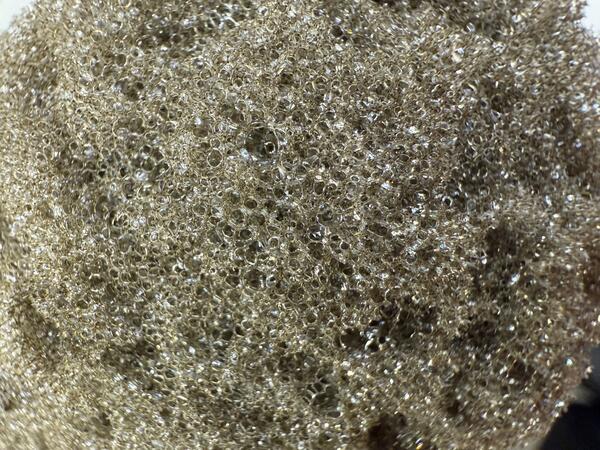
Types of Tephra
Media
Strands of Pele's Hair collect in low-lying areas near Keanakākoʻi Overlook in Hawaiʻi Volcanoes National Park. USGS photo by K. Mulliken.
Sources/Usage: Public Domain. View Media Details
Media
Episode 23 of the ongoing Kīlauea summit eruption in Halema‘uma‘u began with high fountains that deposited tephra outside the caldera to the southwest. Material was still molten as it fell on the landscape, evidenced by the fluid textures shown here. This clast, large enough to be called a volcanic bomb, is over 50 cm (almost two feet) long. USGS photo by K. Lynn.
Sources/Usage: Public Domain. View Media Details
Media
A close-up view looking at one of the more vesicular pieces of tephra from a recent fountaining episode at Kīlauea summit. When the gas-rich lava erupting from the vents quickly cools, it solidifies with this light and frothy texture. The bubble walls are so thin that the color of this tephra is more golden brown. USGS photo taken by L. DeSmither on May 29, 2025.
Sources/Usage: Public Domain. View Media Details
Volcanic Gas Emissions
Large amounts of volcanic gas—primarily water vapor (H2O), carbon dioxide (CO2), and sulfur dioxide (SO2)—are released during lava fountaining episodes at the summit of the Kīlauea. Episodes in the ongoing eruption have produced emission rates up to 75,000 tonnes per day of SO2. It’s likely that sulfur dioxide emission rates have been even higher during some eruptive episodes, though measurements have not been possible. When the lava fountains are not active, SO2 emission rates are decreased and in the range of 1,200 to 1,500 tonnes per day.
The plume of volcanic gas and fine tephra particles rising from the vents has reached more than 20,000 feet (6,000 m) above ground level and is transported by the wind. SO2 reacts in the atmosphere with oxygen, sunlight, moisture, and other gases and particles, and within hours to days, converts to fine particles. The particles scatter sunlight and cause the visible haze that is observed downwind of Kīlauea, known as vog (volcanic smog). Vog creates the potential for airborne health hazards to residents and visitors, damages agricultural crops and other plants, and affects livestock operations.
Further information on vog can be found at https://vog.ivhhn.org/
Wind Conditions Affect Distribution of VOG and Tephra Fall
Media
Sources/Usage: Public Domain. View Media Details
In Hawaii, trade winds refer to the predominant condition of winds that flow from the northeast to the southwest. Where rising warm air from the Earthʻs surface meets the trade winds, an inversion layer exists between 5,000-10,000 feet (1,500-3,000 m) elevation. The inversion inhibits air below from rising above the summits of Mauna Kea and Mauna Loa and causes air to flow around the mountains.
Eruptive plumes at the summit of Kīlauea can rise vertically and be sheared to the southwest where they encounter the trade wind inversion. During trade wind conditions, most volcanic gas and tephra is transported to the southwest. Larger tephra particles fall on the ground within 1-3 miles (1-5 kilometers) of the eruptive vent(s), with the highest concentrations immediately downwind of the vent(s) in the closed area of Hawaiʻi Volcanoes National Park. Light particles, including Pele's hair, can be transported greater distances, 10 miles (15 kilometers) from the vent downwind.
During less common Kona wind conditions, material from Kīlauea summit eruptive plumes may be transported north/west. Slack wind conditions allow eruptive plumes at the summit of Kīlauea to rise buoyantly and billow outwards.
The subtropical jet stream can be at elevations above 10,000 feet (3,000 m) and consist of generally faster winds travelling from west/northwest to east/southeast. The volcanic plumes during the ongoing Kīlauea summit eruption have not encountered the subtropical jet stream.
How to Stay Aware of Eruptive Activity and Hazards
- Read the latest Kīlauea - Volcano Update for information on the status of the eruption
- Check the Hawaiʻi Volcanoes National Park website for information about viewing and closures
- Follow official guidelines; information on potential impacts will come from the Hawaii County Civil Defense Agency
Impacts of Recent Eruptive Episodes
Several lava fountaining episodes have resulted in tephra fall on visitor areas of Hawaiʻi Volcanoes National Park, Highway 11 north of the vents, and neighboring communities. Where tephra falls is dependent on the eruptive episode (how high the lava fountains reach) and wind conditions (where the wind is blowing and how strongly).
Data Disclaimer: The information presented in the table below is intended for public information and awareness and is also used in real-time response messaging (https://volcanoes.usgs.gov/hans-public/search/). All data are unreviewed, preliminary estimates derived from rapid analyses. The data are subject to revision and are not suitable for research, quantitative analyses, or scientific publication. Complete datasets will be released after appropriate review as USGS data releases. Please consult the USGS Hawaiian Volcano Observatory at askHVO@usgs.gov with any questions about data or usage.
| Episode | Date | Fountain Height above vent level | Wind Conditions | Plume Height above ground level unless otherwise noted | Impacts |
| 4 | January 15 - 18, 2025 | 330 feet/100 meters | No/light | Pele’s Hair fell in HAVO, Volcano Golf Course, Volcano Village, Mauna Loa Estates, and Ohia Estates. In some areas, the hair tangled into tumble-weed like structures up to 60 cm (about two feet) long. | |
| 15 | March 26, 2024 | 1070 feet/325 meters | No/light | Tephrafall on Uēkahuna overlook in HAVO (cm-sized); Pele’s Hair fell on Volcano Golf Course and neighboring communities; HVO’s KWcam, F1cam, laser rangefinder power system damaged | |
| 16 | March 31 – April 2, 2025 | 1070 feet/325 meters | No/light | 10,000 feet/3000 meters | Tephra up to about an inch (a couple cm) fell on Highway 11 between mile markers 32 and 33; minor Pele’s Hair fell on Volcano Golf Course; minor brushfire in area northwest of vents on crater rim in closed area of HAVO |
| 23 | May 25, 2025 | 1150 feet/350 meters | Trades (from NE) | at least 5,000 feet/1500 meters | Peleʻs Hair reported in Pāhala |
| 28 | July 9, 2025 | 1050 feet/320 meters | Trades (from NE) | 15,000 feet/4500 meters | Peleʻs Hair reported in Captain Cook and Miloliʻi and on Highway 11 |
| 31 | August 22-23, 2025 | 328 feet/100 meters | Trades (from NE) | 10,000 feet/3000 meters | Pele's Hair deposition was reported in Pāhala |
| 34 | October 1, 2025 | 1230 feet/375 meters | Trades (from NE) | More than 15,000 feet/4500 meters | Fine particles (no larger strands) reported in Ocean View |
| 35 | October 17-18, 2025 | 1480 feet/450 meters | Northerly | More than 20,000 feet/6000 meters | Fist-sized clasts along Hwy 11 between Volcano and Pāhala (nothing reported in Pāhala). Fine ash particles reported in Ocean View. Damage to monitoring solar panels and heat damage to cameras |
| 36 | November 9, 2025 | 1230 feet/375 meters | Trades (from NE) | 10,000 feet/3000 meters | Ash fall reported in Waiʻōhinu; Pele's hair in Pāhala |
| 38 | December 6, 2025 | 1259 feet/384 meters | Trades (from NE) | More than 20,000 feet/6000 meters | Ash fall, Pele's Hair, and limu-o-Pele like material in Pāhala. Ashfall in Waiohinu/Nāʻālehu. Leser amounts of ash fall in Ocean View. |
| 41 | January 24, 2026 | 1475 feet/450 meters | Weak surface level, east/northeasterly winds at high levels | More than 20,000 feet/6000 meters | Tephra fallout densest within 5 miles (8 kilometers) east-northeast of the vents, covering parts of Hawaiʻi Volcanoes National Park and neighboring communities (Volcano Village, Mauna Loa estates, Ohia Estates). Farther away, parts of the Volcano Golf Course Community, Ohia Estates, Royal Hawaiian Estates, and Fern Forest received tephra fall ranging from Pele’s hair and ash to pieces of reticulite that were up to several inches (64 mm) in diameter. Communities even farther away, in the District of Puna and parts of South Hilo, saw light fall or a dusting of fine-grained ash and Pele’s hair, extending from Pepeekeo to Kalapana. NWS issued an ashfall advisory, followed by an ashfall warning. |
| 42 | February 15, 2026 | 1310 feet (400 meters) | Trades (from NE) at ground level, east/northeasterly winds at high levels | 35,000 feet/10,670 meters above sea level (NWS) | Ash reported in Pāhala, Nāʻālehu, Waiʻōhinu, Ocean View. Pele's hair in Pāhala. |
| 43 | March 10, 2026 | 1310 feet (400 meters) | Light and variable ground-level winds, with winds about the inversion level (8,000 to10,000 feet ASML) light from the southwest | 25,000 feet/7,6200 meters above sea level (NWS) | Tephra fallout densest north-northeast of the vents, with continuous coverage at Uēkahuna overlook and Kilauea Military Camp in Hawaiʻi Volcanoes National Park, and Highway 11 nearby and parts of Volcano Golf Course and Volcano Village. Parts of Volcano Golf Course and Volcano Village farther from the vents, and neighboring communities of Mauna Loa estates, Ohia Estates and Royal Hawaiian Estates received less continuous fallout ranging from Pele’s hair and ash to pieces of reticulite that were up to several inches in diameter. Communities even farther away, in the District of Puna and parts of South Hilo, saw light fall or a dusting of fine-grained ash and Pele’s hair, extending to as far at Laupahoehoe to the north. NWS issued an ashfall advisory, followed by an ashfall warning. |
| 44 | April 9, 2026 | 800 feet (240 meters) | Strong southerly winds | 16,000 feet/4,900 meters above sea level (VAAC) | Tephra fell outside of the closed area of Hawaiʻi Volcanoes National Park along the north rim of Kaluapele (Kīlauea caldera) and in adjacent communities. Tephra fall was most dense in the area surrounding Kilauea Military Camp. Tephra as large as 10 inches (25 centimeters) was reported in the Volcano Golf Course subdivision, and fine ash and Pele's hair was reported as far away as Hilo and Nīnole. NWS issued an ashfall warning. |
| 45 | April 23, 2026 | 860 feet (260 meters) | Trades (from NE) | 15,000 feet/4,500 meters above sea level (VAAC) | No significant tephra fallout was reported at visitor areas of Hawaiʻi Volcanoes National Park or on county roads. Winds blew the plume to the south at low altitudes and to the southwest at higher altitudes, with minor amounts of ash fall reported in the community of Pāhala located about 20 miles (32 kilometers) to the southwest of the eruptive vents in Halemaʻumaʻu. NWS issued an ashfall advisory. |
| 46 | May 5, 2026 | 650 feet (200 meters) | Southeasterly (lower level) southwesterly (upper level) | 20,000 feet/6,000 meters above sea level (VAAC) | Fist-sized and smaller tephra fell outside of the closed area of Hawaiʻi Volcanoes National Park along the north rim of Kaluapele (Kīlauea caldera) and on Highway 11 between mile markers 31 and 32. Uēkahuna and Kīlauea overlooks temporarily closed. Pele's hair reported in Volcano Golf Course subdivision. NWS issued an ashfall advisory. |
| 47 | May 14, 2026 | 650 feet (200 meters) | Lower level trades (from NE); upper lever westerly | 20,000 feet/6,000 meters above sea level (VAAC) | Most tephra fell within the closed area of Hawaiʻi Volcanoes National Park, but sparse reticulite up to 3 inches (5 centimeters) in size fell at both the Uēkahuna and Keanakākoʻi overlooks in Hawaiʻi Volcanoes National Park. Fine ash and Peleʻs hair fell outside Hawaiʻi Volcanoes National Park in communities to the northeast, including Mauna Loa Estates, ʻŌhiʻa Estates, Volcano village, and Royal Hawaiian Estates. NWS did not issue an ashfall advisory. |
| 48 | June 1, 2026 | 650 feet (200 meters) | Lower level trades (from NE); upper lever westerly | 24,000 feet/7,300 meters above sea level (VAAC) | Most tephra fell within the closed area of Hawaiʻi Volcanoes National Park, but sparse reticulite up to 1 inch (2 centimeters) in size fell at both the Uēkahuna overlook and on Highway 11 west of Nāmakanipaio campground. Fine ash and Pele's hair was reported from Hawaiʻi Volcanoes National Park in communities to the northeast, including Mauna Loa Estates, Ohia Estates, Volcano village, and Royal Hawaiian Estates. Three flights departing/arriving at Hilo International Airport were cancelled. |
Additional Information
- Search for past volcano updates
- Subscribe to the USGS Volcano Notification Service to receive eruption updates
- Kīlauea geology and history
- Kīlauea Maps
- Vog Information Dashboard
- General Hawai‘i County Civil Defense information or subscribe to CD alerts and updates
- Follow USGS Volcanoes on Twitter, Facebook, and Instagram.
- Volcano viewing information from Hawaii Volcanoes National Park
Recent eruptions have taken place within Hawai‘i Volcanoes National Park. Please visit the Park website to learn more about their operations.
December 23, 2024 - Kīlauea summit eruption
This video, taken from the west rim of Kaluapele (Kīlauea caldera), in the closed area of Hawaiʻi Volcanoes National Park, shows the new eruption that started this morning at 2:20 a.m. HST. At approximately 4:30 a.m. HST, the lava fountains were reaching up to 80 meters (260 feet) and by 5:30 a.m., lava covered an area of approximately 400 acres on the caldera floor. USGS video by D. Downs.
Filter Total Items: 71
December 23, 2024 - Collecting a lava sample
During an overflight at 2:30 p.m. HST today, December 23, USGS Hawaiian Volcano Observatory scientists were able to collect a molten sample of lava from the new eruption within Kaluapele. Kaluapele, the summit caldera of Kīlauea volcano, is the sacred home of the elemental force associated with volcanoes—Pele.
During an overflight at 2:30 p.m. HST today, December 23, USGS Hawaiian Volcano Observatory scientists were able to collect a molten sample of lava from the new eruption within Kaluapele. Kaluapele, the summit caldera of Kīlauea volcano, is the sacred home of the elemental force associated with volcanoes—Pele.
December 23, 2024 - Preparing Kīlauea's newest eruption samples
December 23, 2024 - Preparing Kīlauea's newest eruption samplesKīlauea's newest eruption samples contain olivine - a common green mineral in Hawaiian lavas. USGS Hawaiian Volcano Observatory and University of Hawai‘i at Hilo staff are picking out the olivine crystals like this one, shown using a microscope to magnify it (the crystal is 1 mm in size, or about 0.04 inches across), to analyze their chemistry.
December 23, 2024 - Analyzing Kīlauea's recent eruption samples
December 23, 2024 - Analyzing Kīlauea's recent eruption samplesAfter sample preparation, University of Hawai‘i at Hilo faculty and an undergraduate research student load the most recent Kīlauea eruption sample into the ED-XRF (energy dispersive x-ray fluorescence) for chemical analysis. Within 6 hours of sample collection, the chemical analysis of the lava was completed. USGS photo by K. Lynn.
December 23, 2024—Kīlauea summit eruption reference map
December 23, 2024—Kīlauea summit eruption reference mapThis reference map depicts the new Kīlauea summit eruption within Halema‘uma‘u crater on December 23, 2024, constructed using data captured during a USGS Hawaiian Volcano Observatory helicopter overflight at 9:30 a.m.
December 23, 2024 — Thermal map of eruption at Kīlauea summit
December 23, 2024 — Thermal map of eruption at Kīlauea summitThis thermal map shows lava flows covering the floor of Halemaʻumaʻu crater at the summit of Kīlauea. Fountaining was active in the southwest portion of the caldera, with flows extending east onto the downdropped block. Cooler colors (purple, black) show lower temperatures while hotter colors (orange, yellow) show higher temperatures. USGS map by M.
December 23, 2024 - New eruption in Kīlauea summit caldera
December 23, 2024 - New eruption in Kīlauea summit calderaKīlauea volcano began erupting within the summit caldera at approximately 2:20 a.m. HST this morning, December 23, 2024, following an increase in seismicity that began beneath the summit just a half hour earlier, at approximately 2:00 a.m. HST.
December 23, 2024 - View of the new eruption at the summit of Kīlauea
December 23, 2024 - View of the new eruption at the summit of KīlaueaThis photograph, taken at approximately 4:00 a.m. HST from the Volcano House overlook in Hawaiʻi Volcanoes National Park, shows the new eruption within Kaluapele (the summit caldera).
December 23, 2024 - View from the west rim of Kaluapele
December 23, 2024 - View from the west rim of KaluapeleFrom the closed area of Hawaiʻi Volcanoes National Park, USGS Hawaiian Volcano Observatory geologists documented the new eruption within Kalupele that started this morning at 2:20 a.m. HST.