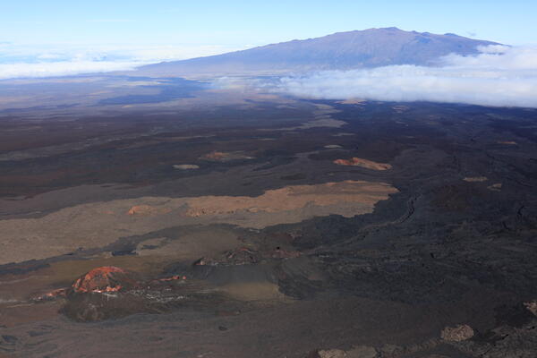
U.S. flag

An official website of the United States government

Multimedia

Images

Color photograph of caldera wall
Kīlauea caldera wall and Mauna Kea—July 19, 2022

Aerial view of the north wall of Kīlauea caldera. The bright green area near the center of the image is the Volcano Golf Course. Between it and the caldera edge is the Kīlauea Military Camp. Mauna Kea rises beyond the slopes of the Northeast Rift Zone of Mauna Loa in the background. USGS image by J. Chang. 

Aerial view of the north wall of Kīlauea caldera. The bright green area near the center of the image is the Volcano Golf Course. Between it and the caldera edge is the Kīlauea Military Camp. Mauna Kea rises beyond the slopes of the Northeast Rift Zone of Mauna Loa in the background. USGS image by J. Chang. 

Color photograph of instrument and mountain
How measuring gravity on Mauna Kea helps us monitor Mauna Loa

A gravimeter measuring the force of gravity on Mauna Kea. These measurements are used to calibrate the instruments so they can precisely monitor changes in gravity from magma accumulation at Mauna Loa (background). USGS photograph taken on December 10, 2020.

A gravimeter measuring the force of gravity on Mauna Kea. These measurements are used to calibrate the instruments so they can precisely monitor changes in gravity from magma accumulation at Mauna Loa (background). USGS photograph taken on December 10, 2020.

Color graphic showing volcano location and seismic data
Example 2-hours of seismic data from station near Mauna Kea

Example 2-hours of seismic data from station near Mauna Kea on April 14, 2020. The large spikes are earthquakes under Mauna Kea repeating every ~11 minutes. Bottom waveform zooms in on 15 seconds of an individual event.

Example 2-hours of seismic data from station near Mauna Kea on April 14, 2020. The large spikes are earthquakes under Mauna Kea repeating every ~11 minutes. Bottom waveform zooms in on 15 seconds of an individual event.

The gentle slope of Mauna Loa as seen from the flanks of Mauna Kea ...

The gentle slope of Mauna Loa as seen from the flanks of Mauna Kea to the north. Younger lava flows appear dark on the volcano's flank, and clouds rest in the eastern saddle between the two volcanoes.

The gentle slope of Mauna Loa as seen from the flanks of Mauna Kea to the north. Younger lava flows appear dark on the volcano's flank, and clouds rest in the eastern saddle between the two volcanoes.

panoramic view of the 1935 Humu‘ula flow

This panoramic view of the 1935 Humu‘ula flow (black lava) on both sides of the Daniel K. Inouye Highway, which runs east to west in the saddle between Mauna Loa (snow-capped shield volcano at far left) and Mauna Kea (distant right), was taken from the top of Pu‘uhuluhulu. View is to the northwest. The top of Hualālai is visible in far distance (center).

This panoramic view of the 1935 Humu‘ula flow (black lava) on both sides of the Daniel K. Inouye Highway, which runs east to west in the saddle between Mauna Loa (snow-capped shield volcano at far left) and Mauna Kea (distant right), was taken from the top of Pu‘uhuluhulu. View is to the northwest. The top of Hualālai is visible in far distance (center).

Sunset on Mauna Kea
Sunset on Mauna Kea
Sunset on Mauna Kea
Sunset on Mauna Kea

Research projects with the USGS take scientists to beautiful places and Mauna Kea volcano on Hawai‘i Island is no exception. Here is a palila field crew camping site on the north slope of Mauna Kea as the sun sets.  

Research projects with the USGS take scientists to beautiful places and Mauna Kea volcano on Hawai‘i Island is no exception. Here is a palila field crew camping site on the north slope of Mauna Kea as the sun sets.  

Videos

November PL 2023 - Thumbnail PubTalk-11/2023: Six Eruptions at Two Volcanoes Over the Past Three Years
PubTalk-11/2023: Six Eruptions at Two Volcanoes Over the Past Three Years

Six Eruptions at Two Volcanoes Over the Past Three Years

How the Hawaiian Volcano Observatory monitors some of Earth’s most active volcanoes

by Katie Mulliken, Geologist, Research Corporation of the University of Hawai‘i and USGS Hawaiian Volcano Observatory

Six Eruptions at Two Volcanoes Over the Past Three Years

How the Hawaiian Volcano Observatory monitors some of Earth’s most active volcanoes

by Katie Mulliken, Geologist, Research Corporation of the University of Hawai‘i and USGS Hawaiian Volcano Observatory

Mauna Loa MKcam (New Webcam)

This video shows a typical day on Mauna Loa, captured from a new webcam looking south towards the volcano. The field of view covers the summit region and much of the Northeast Rift Zone.

This video shows a typical day on Mauna Loa, captured from a new webcam looking south towards the volcano. The field of view covers the summit region and much of the Northeast Rift Zone.