U.S. flag

An official website of the United States government

Multimedia

Multimedia of Ofu-Olosega in American Samoa. 

Images

Color photograph of coast at sunset
August 7, 2023 — Photo of Ofu, Olosega, and Taʻū islands, American Samoa

Early morning photo of the three islands that make up the Manuʻa Islands in American Samoa. Ofu Island is in the foreground, Olosega Island in the middle ground, and Taʻū Island is in the background. Ofu-Olosega islands and Taʻū Island are the tops of volcanoes, most of which are under the ocean surface. USGS photo by D. Downs.

Early morning photo of the three islands that make up the Manuʻa Islands in American Samoa. Ofu Island is in the foreground, Olosega Island in the middle ground, and Taʻū Island is in the background. Ofu-Olosega islands and Taʻū Island are the tops of volcanoes, most of which are under the ocean surface. USGS photo by D. Downs.

Color photograph of island and ocean
August 7, 2023 — View of Olosega Island with Ofu Island in the background, American Samoa

A view of the southeast side of Olosega Island (foreground), with Ofu Island visible in the background. These volcanoes have steep cliffs and are separated by a 50-foot (15 meter) channel. The steep cliff in the photo is a dike sticking out into the ocean that has been more resistant to weathering than surrounding lava flows. USGS photo by D. Downs.

A view of the southeast side of Olosega Island (foreground), with Ofu Island visible in the background. These volcanoes have steep cliffs and are separated by a 50-foot (15 meter) channel. The steep cliff in the photo is a dike sticking out into the ocean that has been more resistant to weathering than surrounding lava flows. USGS photo by D. Downs.

Color map of the Manuʻa Islands, American Samoa
July 2023—Topography and bathymetry of the Manuʻa Islands, American Samoa

This reference map depicts the volcanoes in the Manuʻa Islands, American Samoa, the site of seismic unrest between July and September 2022. Marked on the map are the locations of Hawaiian Volcano Observatory GPS and seismometers in the islands.

This reference map depicts the volcanoes in the Manuʻa Islands, American Samoa, the site of seismic unrest between July and September 2022. Marked on the map are the locations of Hawaiian Volcano Observatory GPS and seismometers in the islands.

Color graphics of earthquakes
Map of American Samoa volcano-monitoring network.

Map of the American Samoa volcano-monitoring network (top). Data from Wake Island hydrograph (located about 4,500 km, or 2,900 miles, northwest of Taʻū Island) shows the general trend in the number of events during the 2022 earthquake swarm (bottom left). Locations for larger earthquakes (M2.5 and greater) are available starting August 20, 2022 (bottom right).

Map of the American Samoa volcano-monitoring network (top). Data from Wake Island hydrograph (located about 4,500 km, or 2,900 miles, northwest of Taʻū Island) shows the general trend in the number of events during the 2022 earthquake swarm (bottom left). Locations for larger earthquakes (M2.5 and greater) are available starting August 20, 2022 (bottom right).

Color bathymetric map
Bathymetric data from the National Oceanic and Atmospheric Administration (NOAA) collected around American Samoa

Bathymetric data from the National Oceanic and Atmospheric Administration (NOAA) collected around American Samoa. Light gray areas are the islands of Tutuila, Ofu-Olosega, and Taʻū. Black lines are 1,640 ft (500 m) contour intervals below sea level.

Bathymetric data from the National Oceanic and Atmospheric Administration (NOAA) collected around American Samoa. Light gray areas are the islands of Tutuila, Ofu-Olosega, and Taʻū. Black lines are 1,640 ft (500 m) contour intervals below sea level.

Color map of islands and nearby bathymetry
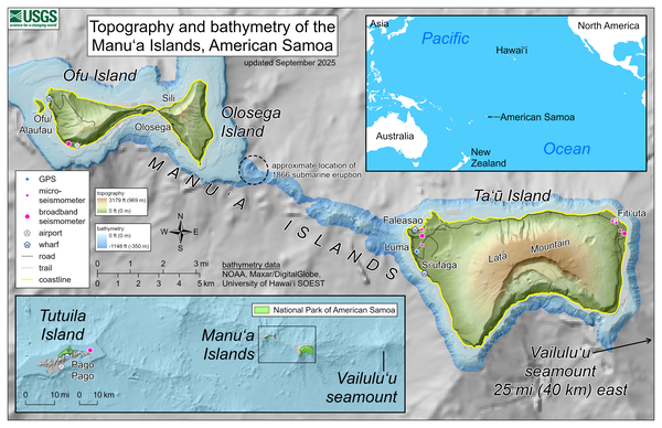
Topography, bathymetry, and volcano monitoring network of the Manu‘a Islands, American Samoa

This reference map depicts the topography and bathymetry of the volcanoes in the Manu‘a Islands, American Samoa. The highest elevation in the area is Lata Mountain on Ta‘ū Island, standing 3,179 feet (969 meters) above sea level.

This reference map depicts the topography and bathymetry of the volcanoes in the Manu‘a Islands, American Samoa. The highest elevation in the area is Lata Mountain on Ta‘ū Island, standing 3,179 feet (969 meters) above sea level.