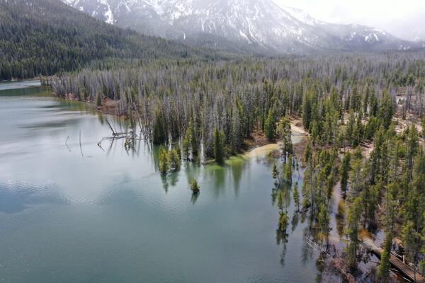
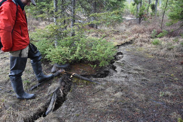
U.S. flag

An official website of the United States government

Images

Images of Yellowstone.

Filter Total Items: 699
Two images showing magma storage beneath Yellowstone Volcano
Two models of magma storage beneath Yellowstone.

Models of magma storage. Part (A) depicts the standard model of magma storage—a single, large body of crystal-poor melt, surrounded by crystalline mush. Although this is the standard 'mush' model, geophysical studies fail to find evidence of this type of magma storage at many active systems.

Models of magma storage. Part (A) depicts the standard model of magma storage—a single, large body of crystal-poor melt, surrounded by crystalline mush. Although this is the standard 'mush' model, geophysical studies fail to find evidence of this type of magma storage at many active systems.

Map showing three types of young faults in Yellowstone National Park

Map showing three types of young faults in Yellowstone National Park. 1) Resurgent dome faults. 2) Volcanism and caldera faults. 3) Basin and Range faults. Courtesy of the Wyoming State Geological Survey.

Image of Yellowstone Lake showing location of core YL16-2C

A digital elevation map of Yellowstone National Park (left) with the location of Yellowstone Lake indicated by the white box. Satellite image (right) of the study site with collection location of core YL16-2C shown by the red circle. Map was originally published in Sabrina Brown’s dissertation (2019).

A digital elevation map of Yellowstone National Park (left) with the location of Yellowstone Lake indicated by the white box. Satellite image (right) of the study site with collection location of core YL16-2C shown by the red circle. Map was originally published in Sabrina Brown’s dissertation (2019).

Four maps displaying the stages of evolution of volcanism in Yellowstone Caldera
Maps of evolution stages of recent volcanism in Yellowstone Caldera
Microtomography 3D image and cathodluminescence slice from quartz crystal Lava Creek Tuff Yellowstone
Microscopic image of quartz crystal from Lave Creek Tuff Yellowstone

Synchrotron X-Ray microtomography 3D image (a) and cathodoluminescence slice (b) from the same reentrant-bearing quartz crystal from the Lava Creek Tuff. The reentrants are in darker blue in (a) and the black cavities in (b). Note their relationship to quartz growth bands. Red domains are small magnetite crystals.

Synchrotron X-Ray microtomography 3D image (a) and cathodoluminescence slice (b) from the same reentrant-bearing quartz crystal from the Lava Creek Tuff. The reentrants are in darker blue in (a) and the black cavities in (b). Note their relationship to quartz growth bands. Red domains are small magnetite crystals.

Summary diagram of the geological record and timing of the Huckleberry Ridge Tuff eruption
Summary geologic record of the Huckleberry Ridge Tuff eruption
Alkaline hot spring outflow channel in the Biscuit Basin with a wide array of phototrophic microbial community textures
Alkaline hot spring outflow channel in the Biscuit Basin

A wide array of phototrophic microbial community textures exhibited in an alkaline (pH ~8.5) hot spring outflow channel in the Biscuit Basin, including thick mats, toadstools, ropes, and pinnacles. The differences in color are due to pigments (chlorophylls, bacteriochlorophylls, and carotenoids) produced by phototrophic microorganisms.

A wide array of phototrophic microbial community textures exhibited in an alkaline (pH ~8.5) hot spring outflow channel in the Biscuit Basin, including thick mats, toadstools, ropes, and pinnacles. The differences in color are due to pigments (chlorophylls, bacteriochlorophylls, and carotenoids) produced by phototrophic microorganisms.

Map of seismicity (yellow circles) in Yellowstone during 2019
Map of seismicity in the Yellowstone region during 2019.

Map of seismicity (yellow circles) in the Yellowstone region during 2019. Gray lines are roads, red line shows the caldera boundary, Yellowstone National Park is outlined by black dashed line, and gray dashed lines denote state boundaries.

Map of seismicity (yellow circles) in the Yellowstone region during 2019. Gray lines are roads, red line shows the caldera boundary, Yellowstone National Park is outlined by black dashed line, and gray dashed lines denote state boundaries.

Map panels showing the distribution of major caldera-forming ash-flow deposits Yellowstone
Map panels showing the distribution of caldera-forming tuff Yellowston

Map panels showing the distribution of major caldera-forming ash-flow deposits from the three major caldera-forming eruptions on the Yellowstone Plateau Volcanic Field. Updated from Christiansen, 2001 (USGS PP 729-G) with new age information.

Map panels showing the distribution of major caldera-forming ash-flow deposits from the three major caldera-forming eruptions on the Yellowstone Plateau Volcanic Field. Updated from Christiansen, 2001 (USGS PP 729-G) with new age information.

Map of Yellowstone National Park showing helium isotope values

Color-coded map showing the range of helium isotope values across Yellowstone National Park. BC = Boundary Creek, GGB = Gibbon Geyser Basin, MHS = Mammoth Hot Springs.

Color-coded map showing the range of helium isotope values across Yellowstone National Park. BC = Boundary Creek, GGB = Gibbon Geyser Basin, MHS = Mammoth Hot Springs.

Dan Dzurisin conducting a leveling survey at Newberry Volcano
Dan Dzurisin
Dan Dzurisin
Dan Dzurisin

Dan Dzurisin, of the Cascades Volcano Observatory, conducting a leveling survey at Newberry Volcano, Oregon, in 2002.

Dan Dzurisin, of the Cascades Volcano Observatory, conducting a leveling survey at Newberry Volcano, Oregon, in 2002.

Sulphur Caldro
Sulphur Caldron
Sulphur Caldron
Sulphur Caldron

Sulphur Caldron -- an example of an acid-sulfate hydrothermal feature in Yellowstone National Park. Photo taken by Blaine McCleskey, September 2008.

Sulphur Caldron -- an example of an acid-sulfate hydrothermal feature in Yellowstone National Park. Photo taken by Blaine McCleskey, September 2008.

View of Castle Geyser, near Old Faithful, in eruption

View of Castle Geyser, near Old Faithful, in eruption, taken from the boardwalk, November 5, 2019.

Everts Thistle with purple flowers
Everts thistle in bloom.

This mountain meadow inhabiting species is generally distinctive in its long copious stem and leaf hairs and inflorescences with congested white to pinkish or light purplish flowering heads that are surrounded by very long stem leaves.

This mountain meadow inhabiting species is generally distinctive in its long copious stem and leaf hairs and inflorescences with congested white to pinkish or light purplish flowering heads that are surrounded by very long stem leaves.

View of Yellowstone Lake under partly cloudy skies. The near shore is forested. The far shore has a smoke plume from a fire.
Image of the north part of Yellowstone Lake from September 2, 2019

Image of the north part of Yellowstone Lake with the smoke plume from the Brimstone Fire in the distance, acquired by the YVO webcam on September 2, 2019, at 2:05 PM MDT.

The Parting of the Waters, on the Continental Divide south of Yellowstone National Park
The Parting of the Waters

The Parting of the Waters, looking southeast. North Two Ocean Creek splits into Atlantic Creek, flowing to the left in the photo, and Pacific Creek, flowing to the right. The wooden sign indicates that it is 3,488 miles to the Atlantic Ocean and 1,353 miles to the Pacific Ocean.

The Parting of the Waters, looking southeast. North Two Ocean Creek splits into Atlantic Creek, flowing to the left in the photo, and Pacific Creek, flowing to the right. The wooden sign indicates that it is 3,488 miles to the Atlantic Ocean and 1,353 miles to the Pacific Ocean.

Aerial view of new thermal area near Tern Lake, Yellowstone.

Aerial view of the new thermal area, in the center left. The existing Tern Lake thermal area is the bright white patch of ground in the upper middle part of the image. West Tern Lake is in the lower right. Research conducted under NPS Geology Programs Milestones Permit 2016-9.

Aerial view of the new thermal area, in the center left. The existing Tern Lake thermal area is the bright white patch of ground in the upper middle part of the image. West Tern Lake is in the lower right. Research conducted under NPS Geology Programs Milestones Permit 2016-9.

Tern Lake hydrothermal area from the ground, Yellowstone

View from the ground of the new thermal area near Tern Lake in Yellowstone National Park. Research conducted under NPS Geology Programs Milestones Permit 2016-9.

View from the ground of the new thermal area near Tern Lake in Yellowstone National Park. Research conducted under NPS Geology Programs Milestones Permit 2016-9.

Grand Canyon of the Yellowstone Lower Falls of Yellowstone River

Lower Falls of the Yellowstone River and the Grand Canyon of the Yellowstone, photographed during a helicopter flyover on August 19, 2019.

Was this page helpful?