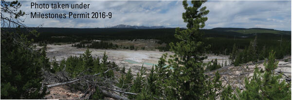
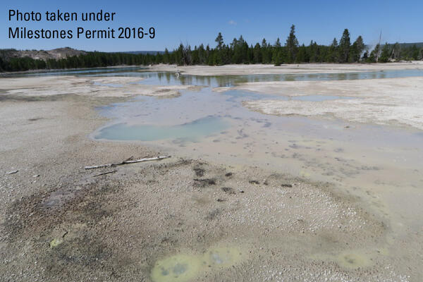
U.S. flag

An official website of the United States government

Images

Images of Yellowstone.

Filter Total Items: 709
Steamboat Geyser in the steam-phase of an eruption on June 4, 2018,...
Steamboat Geyser in the steam-phase of an eruption, Jun 4, 2019

Steamboat Geyser in the steam-phase of an eruption on June 4, 2018, Norris Geyser Basin, Yellowstone National Park.

Map showing the location of active thermal areas

Large hydrothermal explosion craters shown with black dot and leader plus associated breccia deposits in Yellowstone National Park (locations from

Large hydrothermal explosion craters shown with black dot and leader plus associated breccia deposits in Yellowstone National Park (locations from

Looking down into a barren valley with some hot springs. Trees in the foreground and background. Mountain in the far back.
Looking west over The Gap subbasin of Norris Geyser Basin, Yellowstone National Park

Looking west over The Gap subbasin of Norris Geyser Basin, Yellowstone National Park, from a vantage point on the Ragged Hills. The mountain in the distance is Mt. Holmes. Photo taken in June 2018 by Lauren Harrison. 

Map of Yellowstone earthquakes as located by the University of Utah...
Map of Yellowstone earthquakes as located by the Univ. of Utah Seis...

Red circles represent all seismicity and blue circles represent earthquakes as part of earthquake swarms. The size of the circles is scaled to the magnitude of the earthquake. The 630,000 year old Yellowstone caldera is shown as a bold black line within Yellowstone National Park. Mapped faults are shown as light gray lines.

Red circles represent all seismicity and blue circles represent earthquakes as part of earthquake swarms. The size of the circles is scaled to the magnitude of the earthquake. The 630,000 year old Yellowstone caldera is shown as a bold black line within Yellowstone National Park. Mapped faults are shown as light gray lines.

Doublet Pool, fringed by geyserite, in the Upper Geyser Basin of Ye...
Doublet Pool, fringed by geyserite, in the Upper Geyser Basin of YNP.

Doublet Pool, fringed by geyserite, in the Upper Geyser Basin of Yellowstone National Park. National Park Service photograph by Jacob Frank.

Shaded relief map of Yellowstone showing a figure-8 pattern of loops that represent the Howard Eaton trail pathway
Various iterations of the Howard Eaton Trail, Yellowstone National Park

This map shows the Grand Loop Road along with different versions of the Howard Eaton Trail. Over the years, sections of the trail were rerouted to improve visitor safety, reduce maintenance costs, and protect sensitive natural areas. Using National Park Service and USGS sources from 1923, 1937, 1956, 1958, and 1959, students E.

This map shows the Grand Loop Road along with different versions of the Howard Eaton Trail. Over the years, sections of the trail were rerouted to improve visitor safety, reduce maintenance costs, and protect sensitive natural areas. Using National Park Service and USGS sources from 1923, 1937, 1956, 1958, and 1959, students E.

Map showing volcanoes that formed at the leading edge of the Yellowstone hotspot in the past several million years

Map showing volcanoes that formed at the leading edge of the Yellowstone hotspot in the past several million years.  (A) Map of northwest Wyoming, eastern Idaho, and southern Montana (modified from Brueseke et al., 2017, https://doi.org/10.1130/GES01553.1).  Upper Wind River Basin (UWRB) is depicted by dashe

Grant Village boat dock, on the West Thumb of Yellowstone Lake, where a water-level sensor measures lake level
The head of an immature wetsalts tiger beetle at the entrance to the burrow it dug
Head of an immature wetsalts tiger beetle at the entrance to the burrow it dug
Steam-driven vents on the floor of Yellowstone Lake in the Deep Hole,

Steam-driven vents on the floor of Yellowstone Lake in the Deep Hole, east of Stevenson Island. Image acquired by the Global Foundation for Ocean Exploration ROV Yogi in August 2017.

Steam-driven vents on the floor of Yellowstone Lake in the Deep Hole, east of Stevenson Island. Image acquired by the Global Foundation for Ocean Exploration ROV Yogi in August 2017.

Dr. Jacob Lowenstern, Scientist-in-Charge of the Yellowstone Volcano Observatory during 2002-2017.
Dr. Jacob Lowenstern leading a field trip Yellowstone National Park

Dr. Jacob Lowenstern, Scientist-in-Charge of the Yellowstone Volcano Observatory during 2002-2017. In this photo, he's leading a field trip in Yellowstone National Park with a group of international volcanologists. 

Dr. Jacob Lowenstern, Scientist-in-Charge of the Yellowstone Volcano Observatory during 2002-2017. In this photo, he's leading a field trip in Yellowstone National Park with a group of international volcanologists. 

Time series of vertical displacements during April–October 2017 at four GPS stations on the north side of Yellowstone Lake

Time series of vertical displacements during April–October 2017 at four GPS stations (LAK1, LAK2, LKWY, and SEDG) on the north side of Yellowstone Lake. Downward trends indicate subsidence and upward trends show uplift. Uplift “spikes” in late September are related to inclement weather and do not show true deformation. Error bars are one standard deviation.

Time series of vertical displacements during April–October 2017 at four GPS stations (LAK1, LAK2, LKWY, and SEDG) on the north side of Yellowstone Lake. Downward trends indicate subsidence and upward trends show uplift. Uplift “spikes” in late September are related to inclement weather and do not show true deformation. Error bars are one standard deviation.

Roadcut exposure of Huckleberry Ridge Tuff and Mesa Falls Tuff along U.S. Route 20 between Ashton and Island Park, Idaho
Four scientists in safety vests in a grassy meadow with occasional bounders setting up geophysical equipment
Field crew setting up a magnetotelluric site in Yellowstone National Park

Field crew from Oregon State University and University of Wisconsin-Madison install a magnetotelluric site within Yellowstone National Park. 

Changes in snow conditions at a gravity station in Yellowstone 2017

Changes in snow conditions at a gravity station in Yellowstone National Park in 2017. Each photo is taken from about the same location in May, July, August, and October of that year. The red circle in the May photograph shows the location of the gravity station in this area, which is near Craig Pass, a few miles southeast of Old Faithful.

Changes in snow conditions at a gravity station in Yellowstone National Park in 2017. Each photo is taken from about the same location in May, July, August, and October of that year. The red circle in the May photograph shows the location of the gravity station in this area, which is near Craig Pass, a few miles southeast of Old Faithful.

Map of Yellowstone gravity stations measured in 2017

Map of gravity stations measured in 2017 in Yellowstone National Park. Yellow lines are roads, dashed line marks the caldera boundary, black line outlines Yellowstone National Park, green circles note resurgent domes, and red dots are gravity stations.

Map of gravity stations measured in 2017 in Yellowstone National Park. Yellow lines are roads, dashed line marks the caldera boundary, black line outlines Yellowstone National Park, green circles note resurgent domes, and red dots are gravity stations.

WorldView-2 satellite image showing thermal areas on the north side of Mallard Lake resurgent dome in Yellowstone National Park.
Plume of white water and steam emanating from a dark pool of water in a barren area, trees and blue sky in background
Echinus Geyser in eruption in 2017

Echinus Geyser in eruption on October 24, 2017.  Photo by MA Bellingham, used with permission.

View of the Silver Gate landslide complex from Bunsen Peak, Yellowstone National Park
View of the Silver Gate landslide complex from Bunsen Peak

View of the Silver Gate landslide complex from Bunsen Peak in Yellowstone National Park.  The landslide originates from Terrace Mountain.

Weir on a tributary flowing into Boundary Creek in southwest Yellowstone National Park

A weir constructed by Irving Friedman and Dan Norton to measure water discharge and to monitor changes in hydrothermal activity on a tributary flowing into Boundary Creek in southwest Yellowstone National Park. USGS photo by Shaul Hurwitz, September 17, 2017.

A weir constructed by Irving Friedman and Dan Norton to measure water discharge and to monitor changes in hydrothermal activity on a tributary flowing into Boundary Creek in southwest Yellowstone National Park. USGS photo by Shaul Hurwitz, September 17, 2017.

Was this page helpful?