
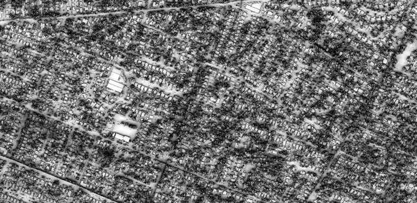
A modified hillshade rendering from lidar-derived DSM data over part of the Eaton Fire
Images
The 3DEP Multimedia Gallery is a collection of graphics related to elevation data. All items in this gallery are considered public domain unless otherwise noted.
Filter Total Items: 165

Eaton fire modified hillshade
A modified hillshade rendering from lidar-derived DSM data over part of the Eaton Fire
Prefire Modified Hillshade over the Eaton Fire
A modified hillshade of a prefire lidar-derived digital surface model over a portion of the Eaton wildfire
A modified hillshade of a prefire lidar-derived digital surface model over a portion of the Eaton wildfire

Eaton Fire hillshade rendering
A modified hillshade rendering from lidar-derived DSM data over the Eaton Fire showing burned structures
A modified hillshade rendering from lidar-derived DSM data over the Eaton Fire showing burned structures

Eaton Fire Modified Hillshade over NASA Jet Propulsion Lab Campus
Eaton Fire Modified Hillshade over NASA Jet Propulsion Lab CampusA modified hillshade rendering from lidar-derived DSM data over the NASA Jet Propulsion Lab Campus
Eaton Fire Modified Hillshade over NASA Jet Propulsion Lab Campus
Eaton Fire Modified Hillshade over NASA Jet Propulsion Lab CampusA modified hillshade rendering from lidar-derived DSM data over the NASA Jet Propulsion Lab Campus

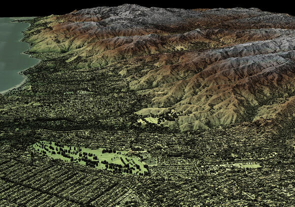
Post Wildfire 3D Rendering of a Lidar-Derived DSM of the Area Around Altadena, CA
Post Wildfire 3D Rendering of a Lidar-Derived DSM of the Area Around Altadena, CAPost wildfire 3D rendering of a lidar-derived DSM of the area around Altadena, CA with a green to gray symbology
Post Wildfire 3D Rendering of a Lidar-Derived DSM of the Area Around Altadena, CA
Post Wildfire 3D Rendering of a Lidar-Derived DSM of the Area Around Altadena, CAPost wildfire 3D rendering of a lidar-derived DSM of the area around Altadena, CA with a green to gray symbology

Post Wildfire Lidar-derived DSM of the Area around the NASA Jet Propulsion Laboratory Campus, CA
Post Wildfire Lidar-derived DSM of the Area around the NASA Jet Propulsion Laboratory Campus, CAPost Wildfire Lidar-derived DSM of the Area around the NASA Jet Propulsion Laboratory Campus, CA with a green to brown symbology

Post Wildfire Lidar-derived DSM of Eaton, CA
Post Wildfire Lidar-derived DSM showing the full extent of the Eaton, CA Wildfire with a green to gray symbology
Post Wildfire Lidar-derived DSM showing the full extent of the Eaton, CA Wildfire with a green to gray symbology

Palisades CA Post-Wildfire Lidar Data from Jan 2025
Palisades CA Post-Wildfire Lidar Data from Jan 2025Lidar point cloud of Palisades CA post-wildfire. Lidar was collected in winter 2025, while no snow was on the ground and rivers were at or below normal levels. Due to the Palisades wildfire, ground conditions are not to be considered normal given the devastation that took place
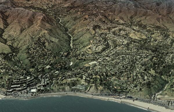
Post Wildfire Lidar-derived DSM of the Area Around Castle Rock Beach, Los Angeles, CA
Post Wildfire Lidar-derived DSM of the Area Around Castle Rock Beach, Los Angeles, CAPost Wildfire Lidar-derived DSM of the Area Around Castle Rock Beach, Los Angeles, CA with semi-transparent imagery overlaid
Post Wildfire Lidar-derived DSM of the Area Around Castle Rock Beach, Los Angeles, CA
Post Wildfire Lidar-derived DSM of the Area Around Castle Rock Beach, Los Angeles, CAPost Wildfire Lidar-derived DSM of the Area Around Castle Rock Beach, Los Angeles, CA with semi-transparent imagery overlaid

Los Angeles CA Post-Wildfire Lidar Data from Jan 2025
Los Angeles CA Post-Wildfire Lidar Data from Jan 2025Lidar point cloud of Los Angeles CA post-wildfire. Lidar was collected in winter 2025, while no snow was on the ground and rivers were at or below normal levels. Due to the Palisades wildfire, ground conditions are not to be considered normal given the devastation that took place
Palisades CA Post-Wildfire Lidar Data from Jan 2025
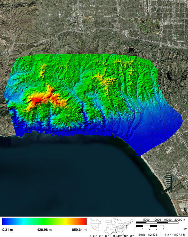
Palisades CA Post-Wildfire Lidar Data from Jan 2025Digital Elevation Model (DEM) data for Response and Recovery as part of the Palisades wildfire in California. Class 2 (ground) LiDAR points were used to create the 0.5 meter Raster DEM symbolized with red to blue (high elevation to low elevation). DEMs have not been manually reviewed and should be considered preliminary.
Palisades CA Post-Wildfire Lidar Data from Jan 2025
Palisades CA Post-Wildfire Lidar Data from Jan 2025Digital Elevation Model (DEM) data for Response and Recovery as part of the Palisades wildfire in California. Class 2 (ground) LiDAR points were used to create the 0.5 meter Raster DEM symbolized with red to blue (high elevation to low elevation). DEMs have not been manually reviewed and should be considered preliminary.

Palisades CA Post-Wildfire Lidar Data from Jan 2025
Palisades CA Post-Wildfire Lidar Data from Jan 2025Lidar point cloud of Palisades CA post-wildfire. Lidar was collected in winter 2025, while no snow was on the ground and rivers were at or below normal levels. Due to the Palisades wildfire, ground conditions are not to be considered normal given the devastation that took place

Los Angeles CA Post-Wildfire Lidar Data from Jan 2025
Los Angeles CA Post-Wildfire Lidar Data from Jan 2025Lidar point cloud of Los Angeles CA post-wildfire. Lidar was collected in winter 2025, while no snow was on the ground and rivers were at or below normal levels. Due to the Palisades wildfire, ground conditions are not to be considered normal given the devastation that took place

Post Wildfire Lidar-derived DSM of the Area Around Topanga Beach, Los Angeles, CA
Post Wildfire Lidar-derived DSM of the Area Around Topanga Beach, Los Angeles, CAPost Wildfire Lidar-derived DSM of the Area Around Topanga Beach, Los Angeles, CA with a green to brown symbology
Post Wildfire Lidar-derived DSM of the Area Around Topanga Beach, Los Angeles, CA
Post Wildfire Lidar-derived DSM of the Area Around Topanga Beach, Los Angeles, CAPost Wildfire Lidar-derived DSM of the Area Around Topanga Beach, Los Angeles, CA with a green to brown symbology
Post Wildfire Lidar-derived DSM of the Area Around Will Rogers State Historic Park, Los Angeles, CA
Post Wildfire Lidar-derived DSM of the Area Around Will Rogers State Historic Park, Los Angeles, CAPost Wildfire Lidar-derived DSM of the Area Around Will Rogers State Historic Park, Los Angeles, CA with a green to brown symbology

Palisades CA Post-Wildfire Lidar Data from Jan 2025
Palisades CA Post-Wildfire Lidar Data from Jan 2025Lidar point cloud of Palisades CA post-wildfire. Lidar was collected in winter 2025, while no snow was on the ground and rivers were at or below normal levels. Due to the Palisades wildfire, ground conditions are not to be considered normal given the devastation that took place

Post Wildfire Lidar-derived DSM of the Area Around Will Rogers Beach State Park, Los Angeles, CA
Post Wildfire Lidar-derived DSM of the Area Around Will Rogers Beach State Park, Los Angeles, CAPost Wildfire Lidar-derived DSM of the Area Around Will Rogers Beach State Park, Los Angeles, CA with semi-transparent imagery overlaid

Post Wildfire Lidar-derived DSM of Pacific Palisades, Los Angeles, CA
Post Wildfire Lidar-derived DSM of Pacific Palisades, Los Angeles, CAPost Wildfire Lidar-derived DSM of Pacific Palisades, Los Angeles, CA with a green to brown symbology
Post Wildfire Lidar-derived DSM of Pacific Palisades, Los Angeles, CA
Post Wildfire Lidar-derived DSM of Pacific Palisades, Los Angeles, CAPost Wildfire Lidar-derived DSM of Pacific Palisades, Los Angeles, CA with a green to brown symbology
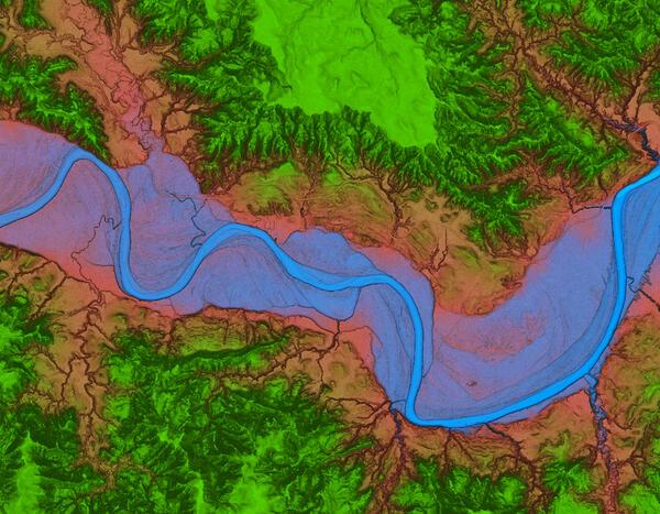
Theodore Roosevelt National Park 3DEP Lidar derived DEM Blue Green
Theodore Roosevelt National Park 3DEP Lidar derived DEM Blue GreenOverhead blue green view of Theodore Roosevelt National Park from 3DEP Lidar derived DEM USGS_OPR_McKenzie_County_2014_QL2_Lidar
Theodore Roosevelt National Park 3DEP Lidar derived DEM Blue Green
Theodore Roosevelt National Park 3DEP Lidar derived DEM Blue GreenOverhead blue green view of Theodore Roosevelt National Park from 3DEP Lidar derived DEM USGS_OPR_McKenzie_County_2014_QL2_Lidar
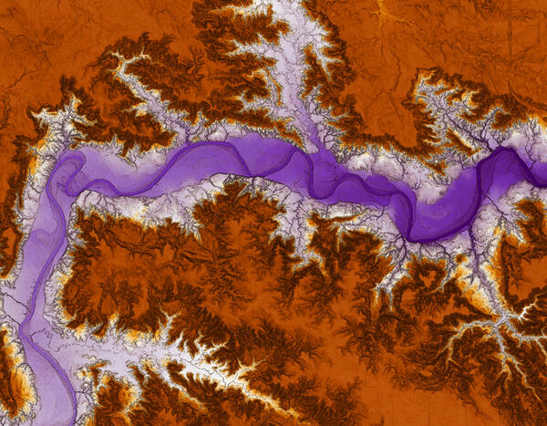
Theodore Roosevelt National Park 3DEP Lidar derived DEM
Theodore Roosevelt National Park 3DEP Lidar derived DEMOverhead view of Theodore Roosevelt National Park from 3DEP Lidar derived DEM USGS_OPR_McKenzie_County_2014_QL2_Lidar
Theodore Roosevelt National Park 3DEP Lidar derived DEM
Theodore Roosevelt National Park 3DEP Lidar derived DEMOverhead view of Theodore Roosevelt National Park from 3DEP Lidar derived DEM USGS_OPR_McKenzie_County_2014_QL2_Lidar