U.S. flag

An official website of the United States government

Images

The 3DEP Multimedia Gallery is a collection of graphics related to elevation data. All items in this gallery are considered public domain unless otherwise noted.

Filter Total Items: 165
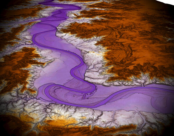
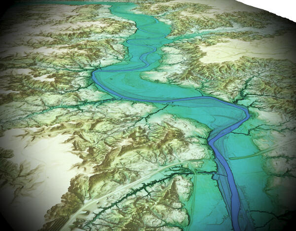
Theodore Roosevelt National Park 3DEP Lidar derived DEM 3D Pastel

3D pastel view of Theodore Roosevelt National Park from 3DEP Lidar derived DEM USGS_OPR_McKenzie_County_2014_QL2_Lidar

Theodore Roosevelt National Park 3DEP Lidar derived DEM 3D Blue Green

3D view of Theodore Roosevelt National Park from 3DEP Lidar derived DEM USGS_OPR_McKenzie_County_2014_QL2_Lidar

Theodore Roosevelt National Park 3DEP Lidar derived DEM 3D

3D view of Theodore Roosevelt National Park from 3DEP Lidar derived DEM USGS_OPR_McKenzie_County_2014_QL2_Lidar

Washington, DC 3DEP Lidar derived DSM Time in Daylight

An image utilizing 3DEP-derived Digital Surface Model (DSM) and Time in Daylight calculation for Washington, DC.

Project: USGS_LPC_Sandy_Supplemental_NCR_VA_MD_DC_QL2_LiDAR

An image utilizing 3DEP-derived Digital Surface Model (DSM) and Time in Daylight calculation for Washington, DC.

Project: USGS_LPC_Sandy_Supplemental_NCR_VA_MD_DC_QL2_LiDAR

Theodore Roosevelt National Park 3DEP Lidar derived DEM Pastel

Overhead pastel view of Theodore Roosevelt National Park from 3DEP Lidar derived DEM USGS_OPR_McKenzie_County_2014_QL2_Lidar

3D Elevation Program FY24 Partnerships

This map of the United States and its territories shows geographic extent of planned, existing, and in-progress 3DEP data acquisition projects.

This map of the United States and its territories shows geographic extent of planned, existing, and in-progress 3DEP data acquisition projects.

FY24 Status of 3DEP Quality Data

This map of the United States and its territories shows the areal extent and quality level of planned, in-progress, and existing publicly available lidar (IfSAR in Alaska) data identified by the United States Interagency Elevation Inventory (USIEI) that meet 3DEP base level specification planned to be under award by September 30, 2024. 3DEP base level spec

This map of the United States and its territories shows the areal extent and quality level of planned, in-progress, and existing publicly available lidar (IfSAR in Alaska) data identified by the United States Interagency Elevation Inventory (USIEI) that meet 3DEP base level specification planned to be under award by September 30, 2024. 3DEP base level spec

Lidar Point Cloud of the White House and the US Department of Commerce in the Herbert Hoover Federal Building
Lidar Point Cloud of the White House and the Herbert Hoover Federal Building

Lidar Point Cloud of the White House and the US Department of Commerce in the Herbert Hoover Federal Building with a green to gray color ramp symbology with green representing low elevation, and gray representing high elevation

Lidar Point Cloud of Delicate Arch at Arches National Park

3D Rendering of lidar point cloud over Delicate Arch. From USGS_LPC_UT_FEMA_FS_FlamingGorge_2020_B20_12SXH300885.laz. Delicate Arch at Arches National Park in Moab, Utah with a green to gray color ramp symbology with green representing low elevation, and gray representing high elevation

3D Rendering of lidar point cloud over Delicate Arch. From USGS_LPC_UT_FEMA_FS_FlamingGorge_2020_B20_12SXH300885.laz. Delicate Arch at Arches National Park in Moab, Utah with a green to gray color ramp symbology with green representing low elevation, and gray representing high elevation

3DEP Map FY24 Partnerships and DCA Projects

This map of the United States and its territories shows geographic extent of completion of the first-ever national baseline of consistent high-resolution elevation data - both bare earth and 3D point clouds.

This map of the United States and its territories shows geographic extent of completion of the first-ever national baseline of consistent high-resolution elevation data - both bare earth and 3D point clouds.

Glacier Bay, Alaska Lidar Point Cloud Colorized with Imagery
Glacier Bay, Alaska Colorized Lidar Point Cloud

Lidar point cloud from Glacier Bay, Alaska, collected in 2019, colorized with National Agriculture Imagery Program data.

Lidar point cloud from Glacier Bay, Alaska, collected in 2019, colorized with National Agriculture Imagery Program data.

FY23 Status of 3DEP Quality Data

This map of the United States and its territories shows the areal extent and quality level of planned, in-progress, and existing publicly available lidar (IfSAR in Alaska) data identified by the United States Interagency Elevation Inventory (USIEI) that meet 3DEP base level specification planned to be under award by September 30, 2023. 3DEP base level spec

This map of the United States and its territories shows the areal extent and quality level of planned, in-progress, and existing publicly available lidar (IfSAR in Alaska) data identified by the United States Interagency Elevation Inventory (USIEI) that meet 3DEP base level specification planned to be under award by September 30, 2023. 3DEP base level spec

Map showing 3D Elevation Program FY23 Partnerships
3D Elevation Program FY23 Partnerships

This map of the United States and its territories shows geographic extent of planned, existing, and in-progress 3DEP data acquisition projects.

This map of the United States and its territories shows geographic extent of planned, existing, and in-progress 3DEP data acquisition projects.

Map of FY23 3D Elevation Program projects supported by Inflation Reduction Act funds.

Map shows geographic extent of the first-ever national baseline of consistent high-resolution elevations – both bare earth and 3D point clouds. FY23 projects are the result of partnership projects awarded through the 3DEP Broad Agency Announcement (BAA) and through on-going Federal coordination via the 3DEP working group.

Map shows geographic extent of the first-ever national baseline of consistent high-resolution elevations – both bare earth and 3D point clouds. FY23 projects are the result of partnership projects awarded through the 3DEP Broad Agency Announcement (BAA) and through on-going Federal coordination via the 3DEP working group.

3DEP Quality Data by Collection Year

3DEP Quality Data by Collection Year 

Age of 3DEP

Dark Green: Planned FY23

Light Green - Red: 2022 - 2004

Gray: Data Contribution Pending

3DEP Quality Data by Collection Year 

Age of 3DEP

Dark Green: Planned FY23

Light Green - Red: 2022 - 2004

Gray: Data Contribution Pending

Lidar Point Cloud of Devil's Tower National Monument

Lidar Point Cloud of Devil's Tower National Monument in Wyoming with a brown to gray color ramp symbology with brown representing low elevation, and gray representing high elevation

Lidar Point Cloud of Devil's Tower National Monument in Wyoming with a brown to gray color ramp symbology with brown representing low elevation, and gray representing high elevation

Was this page helpful?