
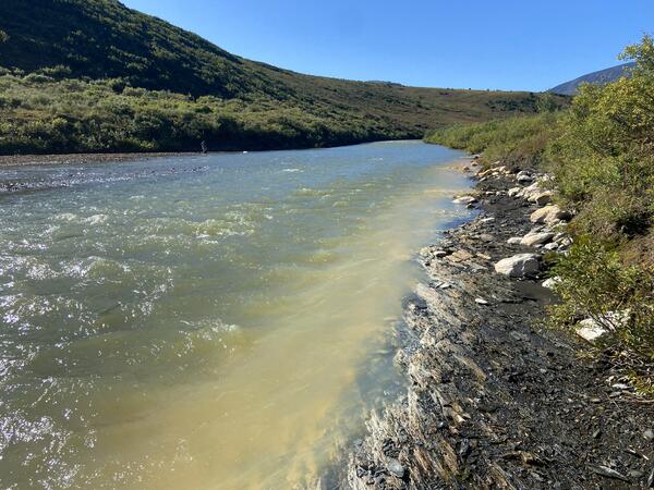
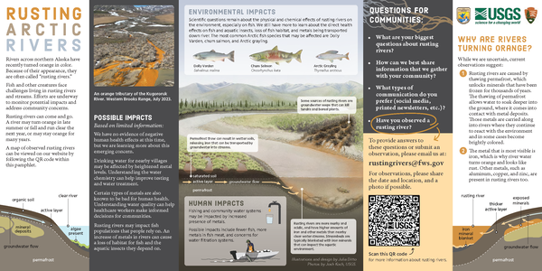
Orange streams are increasingly common in the Brooks Range of northern Alaska. The orange stream color reflects oxidized iron, but also often indicates elevated heavy metal concentrations. Our ongoing study aims to document these occurrences and the timing of their onset.
Images
Browse images from a wide range of science topics covered by USGS. All items in this gallery are considered public domain unless otherwise noted.
Filter Total Items: 1611
Anatok Creek, Kobuk Valley National Park, Alaska
Orange streams are increasingly common in the Brooks Range of northern Alaska. The orange stream color reflects oxidized iron, but also often indicates elevated heavy metal concentrations. Our ongoing study aims to document these occurrences and the timing of their onset.
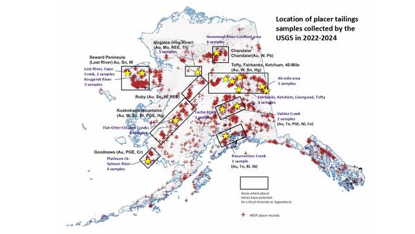
Alaska locations of USGS placer tailings sampling sites
Alaska locations of USGS placer tailings sampling sitesMap showing locations of placer mines in the Alaska Resource Data File (ARDF, red crosses), primary mineral districts that contain targeted critical minerals (black boxes) and locations that were sampled by the USGS in 2022 through 2024 (yellow stars).
USGS Measures Glacial Flooding in Juneau, Alaska
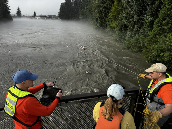
USGS scientists measure flooding on the Mendenhall River as water releases from Suicide Basin’s glacier-dammed lake on August 13, 2025.
USGS scientists measure flooding on the Mendenhall River as water releases from Suicide Basin’s glacier-dammed lake on August 13, 2025.

Sunset over Katmai
The sun sets over Katmai National Park and Preserve. Katmai is one of four monitoring sites for the Nearshore Component of the Gulf Watch Alaska program.
The sun sets over Katmai National Park and Preserve. Katmai is one of four monitoring sites for the Nearshore Component of the Gulf Watch Alaska program.

Waiting for passengers at Katmai National Park and Preserve
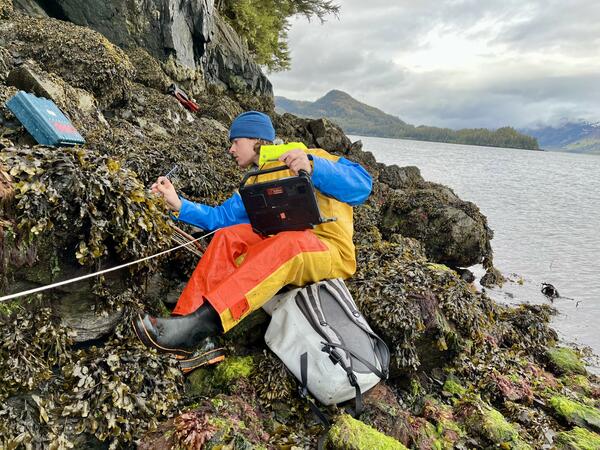
Waiting for passengers at Katmai National Park and PreserveRidged hull inflatable skiffs are used by scientists to conduct rocky intertidal monitoring for the Nearshore Component of the Gulf Watch Alaska program. Data are collected to estimate percent cover and densities of intertidal invertebrates and algae to assess change in communities from sheltered rocky shorelines.
Waiting for passengers at Katmai National Park and Preserve
Waiting for passengers at Katmai National Park and PreserveRidged hull inflatable skiffs are used by scientists to conduct rocky intertidal monitoring for the Nearshore Component of the Gulf Watch Alaska program. Data are collected to estimate percent cover and densities of intertidal invertebrates and algae to assess change in communities from sheltered rocky shorelines.

A retrieved HOBO temperature logger at Katmai National Park and Preserve
A retrieved HOBO temperature logger at Katmai National Park and PreserveA scientist holds a HOBO temperature logger that was recently retrieved from a sampling site at Katmai National Park and Preserve. The sensor end of the HOBO was partially covered by a small sea star (Leptasterias spp.) when recovered from the site. The temperature loggers record the water temperature.

Scientists observing foraging sea otters through telescopes
Scientists observing foraging sea otters through telescopesA pair of scientists observe sea otter foraging behavior at Katmai National Park and Preserve. Questar telescopes are used to assist with prey identification.
Scientists observing foraging sea otters through telescopes
Scientists observing foraging sea otters through telescopesA pair of scientists observe sea otter foraging behavior at Katmai National Park and Preserve. Questar telescopes are used to assist with prey identification.
Sleeping sea otter
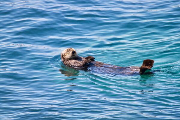
A male Northern Sea Otter sleeps on his back after foraging for clams at Katmai National Park and Preserve.
A male Northern Sea Otter sleeps on his back after foraging for clams at Katmai National Park and Preserve.

Bumble bee pollinating a wild celery (Angelica lucida) flower at Katmai National Park and Preserve
Bumble bee pollinating a wild celery (Angelica lucida) flower at Katmai National Park and PreserveA native bubble bee pollinates a wild celery. There are 22 species of bumblebees in Alaska and all are essential pollinators during the short growing season.
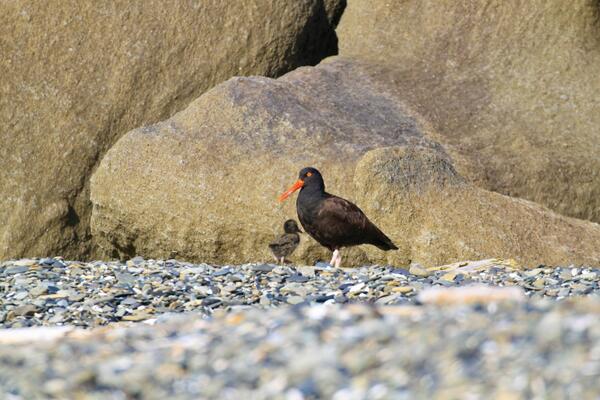
Black Oystercatcher and chick at Katmai National Park and Preserve
Black Oystercatcher and chick at Katmai National Park and PreserveA Black Oystercatcher watches over a few days-old chick at Katmai National Park and Preserve. These shorebirds are monitored on a yearly basis as part of the Gulf Watch Alaska (GWA) long-term monitoring program.
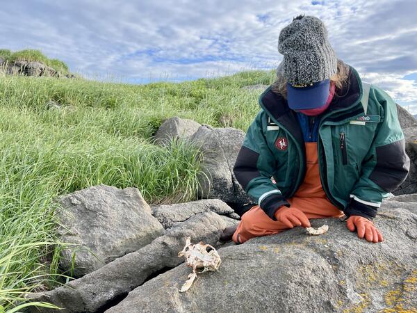
A scientist examines the teeth and skull of a sea otter
A scientist examines the teeth and skull of a sea otterA scientist examines the teeth from a sea otter skull found on a beach at Katmai Nation Park and Preserve. Teeth are collected in the field and each sea otter is aged using cementum annuli counts. Cementum annuli are the rings of collagen fibers in tooth roots.
Rusting Arctic Rivers Pamphlet
Rivers across northern Alaska have recently turned orange in color. Because of their appearance, they are often called “rusting rivers.”
Rivers across northern Alaska have recently turned orange in color. Because of their appearance, they are often called “rusting rivers.”
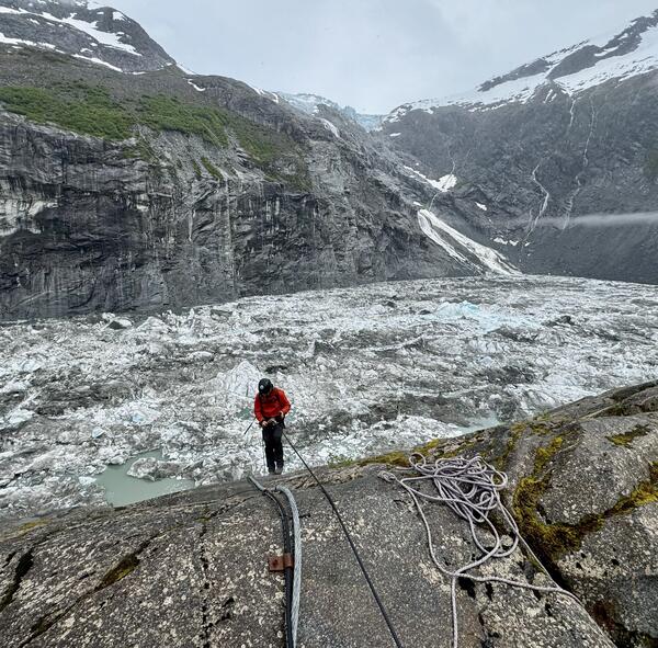
Suicide Basin above Juneau Alaska
USGS staff inspecting monitoring equipment in Suicide Basin. Suicide Basin is a side basin of the Mendenhall Glacier above Juneau, Alaska.
USGS staff inspecting monitoring equipment in Suicide Basin. Suicide Basin is a side basin of the Mendenhall Glacier above Juneau, Alaska.
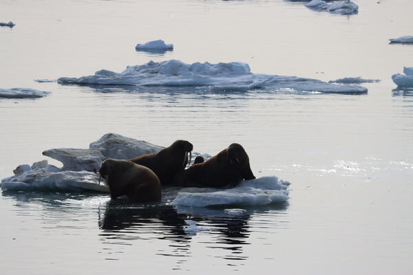
Pacific walruses hauled out on sea ice evaluating their surroundings
Pacific walruses hauled out on sea ice evaluating their surroundingsA small group of Pacific walruses consider entering the water as they assess their surroundings. A calf can be seen in the back of the group. USGS and the U.S.
Pacific walruses hauled out on sea ice evaluating their surroundings
Pacific walruses hauled out on sea ice evaluating their surroundingsA small group of Pacific walruses consider entering the water as they assess their surroundings. A calf can be seen in the back of the group. USGS and the U.S.
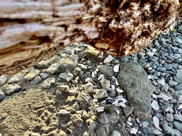
Black Oystercatcher nest under driftwood
Black Oystercatcher (Haematopus bachmani) nests in the northern Gulf of Alaska are monitored annually to determine the nest status, productivity, chick diet, and egg float stages.
Black Oystercatcher (Haematopus bachmani) nests in the northern Gulf of Alaska are monitored annually to determine the nest status, productivity, chick diet, and egg float stages.
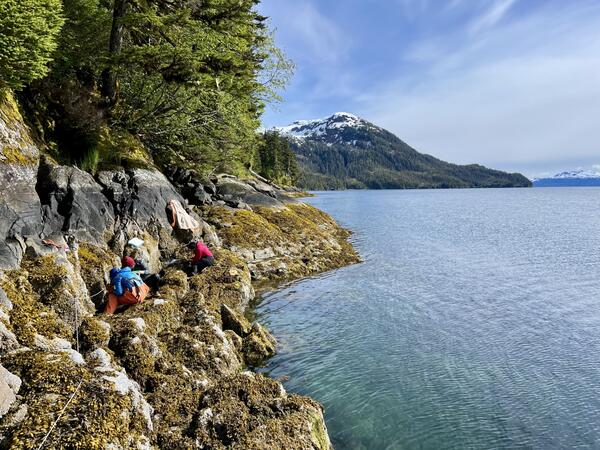
Monitoring mussel beds along the rocky coastline of western Prince William Sound, Alaska
Monitoring mussel beds along the rocky coastline of western Prince William Sound, AlaskaTwo scientists work to identify change in the density and size distribution of mussels (Mytilus trossulus) in mussel beds. Long-term data collected are used as an indicator of mussel prey availability for various predators, including Sea Otters, Black Oystercatchers, sea ducks and sea stars.
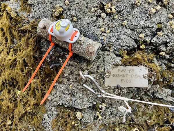
Air and water temperature collection at long-term rocky intertidal monitoring site
Air and water temperature collection at long-term rocky intertidal monitoring siteA temperature logger (HOBO) affixed to a rocky outcrop in western Prince Wiliam Sound. Long-term change in intertidal invertebrate and algal communities is assessed by using temperature loggers.
Rocky intertidal cover estimate in Prince William Sound, Alaska
Rocky intertidal cover estimate in Prince William Sound, AlaskaA scientist estimates percent cover and densities of intertidal invertebrates and algae to assess change in communities from sheltered rocky shorelines in western Prince William Sound, Alaska.

Timelapse of Anchor River at Anchor Point in Alaska
Timelapse of Anchor River at Anchor Point in AlaskaTwo cameras were installed in December of 2024 on the Anchor River to monitor flooding associated with river ice. Traditional hydrologic monitoring is often ineffective when rivers freeze and break up and the cameras provide information needed by our partners to verify water levels and issue flood forecasts.

Pingo 2
An IfSAR DEM image of thaw lake basins (right) in an otherwise flat Arctic coastal plains topography. IfSAR data was collected for Alaska between 2012-2020.
An IfSAR DEM image of thaw lake basins (right) in an otherwise flat Arctic coastal plains topography. IfSAR data was collected for Alaska between 2012-2020.

Permafrost zones across Alaska
This map depicts the permafrost zones across Alaska, overlain by project focus areas. The hashed turquoise region represents areas where pingo mapping is being prioritized. The lime green color outlines the 1002 area, where surficial geological maps are being used to generate more reliable predictors for ground ice content.
This map depicts the permafrost zones across Alaska, overlain by project focus areas. The hashed turquoise region represents areas where pingo mapping is being prioritized. The lime green color outlines the 1002 area, where surficial geological maps are being used to generate more reliable predictors for ground ice content.