
Photograph of Brett D. Johnston taken in Winter Garden, Florida, facing forward with a neutral expression.
Images
Images intro.
Filter Total Items: 185

Picture of Brett D. Johnston
Photograph of Brett D. Johnston taken in Winter Garden, Florida, facing forward with a neutral expression.
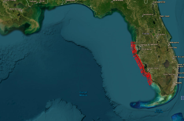
USGS Coastal Change Experts Warn of Heightened Risks for Florida’s West Coast as Hurricane Milton Approaches in the aftermath of Helene
USGS Coastal Change Experts Warn of Heightened Risks for Florida’s West Coast as Hurricane Milton Approaches in the aftermath of HeleneScreenshot of the USGS Coastal Changes Hazards Portal, showing the forecasted coastal change along Florida's Western coast. Screenshot captured on 10/7/2024 at 3:00PM ET.

USGS installs wave sensors in Florida before Hurricane Milton makes landfall
USGS installs wave sensors in Florida before Hurricane Milton makes landfallJulie Hobbs, a USGS hydrologic technician, installs a wave sensor near Venice, Fla., Monday, October 7, 2024, ahead of Hurricane Milton’s projected landfall in Florida’s Gulf Coast Wednesday. USGS photo by Sean Townsend.

USGS deploys wave sensors along Florida's coast ahead of Hurricane Helene
USGS deploys wave sensors along Florida's coast ahead of Hurricane HeleneTim Fiori, a USGS hydrologic technician, installs a barometric pressure sensor at Venice, Fla., Wednesday, Sept. 25, 2024 ahead of Hurricane Helene's projected landfall in Florida Thursday. (USGS photo by Julie Hobbs)

USGS deploys wave sensors along Florida's coast ahead of Hurricane Helene
USGS deploys wave sensors along Florida's coast ahead of Hurricane HeleneJulie Hobbs, a USGS hydrologic technician, installs a wave sensor at Long Boat Key, Fla., Wednesday, Sept. 25, 2024 ahead of Hurricane Helene's projected landfall in Florida Thursday. (USGS photo by Tim Fiori)

USGS deploys wave sensors along Florida's coast ahead of Hurricane Helene
USGS deploys wave sensors along Florida's coast ahead of Hurricane HeleneTim Fiori, a USGS hydrologic technician, installs a wave sensor at Long Boat Key, Fla., Wednesday, Sept. 25, 2024 ahead of Hurricane Helene's projected landfall in Florida Thursday. (USGS photo by Julie Hobbs)

USGS responds to Tropical Storm Debby across Florida, Georgia, North Carolina and South Carolina
USGS responds to Tropical Storm Debby across Florida, Georgia, North Carolina and South CarolinaMike Ludwig, a U.S. Geological Survey hydrologic technician, reads measurements from a streamgage while sitting on a partially submerged park table in Zephyrhills, Fla., Aug. 7, 2024 just days after Tropical Storm Debby struck Florida's Gulf Coast. (Photo by Todd Dunkle, USGS).

USGS responds to Tropical Storm Debby across Florida, Georgia, North Carolina and South Carolina
USGS responds to Tropical Storm Debby across Florida, Georgia, North Carolina and South CarolinaColette Morris, a U.S. Geological Survey hydrologic technician, takes measurements from a streamgage in Flatford Swamp, Fla., Aug. 7, 2024 just days after Tropical Storm Debby struck Florida's Gulf Coast. (Photo by Don Hampton, USGS).

USGS responds to Tropical Storm Debby across Florida, Georgia, North Carolina and South Carolina
USGS responds to Tropical Storm Debby across Florida, Georgia, North Carolina and South CarolinaNick Stanton, a U.S. Geological Survey hydrologic technician, takes floodwater measurements on a road overtopped with water near Parrish, Fla., Aug. 6, 2024 just days after Tropical Storm Debby struck Florida's Gulf Coast. (Photo by Patrick Marasco, USGS).

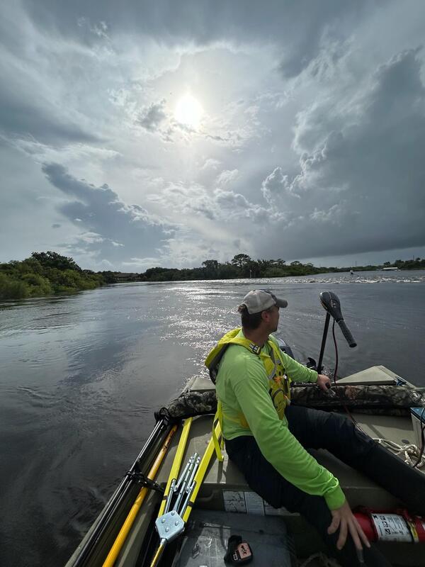
U.S. Geological Survey responds to TS Debby across Southeast
U.S. Geological Survey responds to TS Debby across SoutheastU.S. Geological Survey hydrologic technician Todd Dunkle takes high water measurements with a remote-controlled boat in Clearwater, Fla. Aug. 5, 2024, hours after Tropical Storm Debby made landfall along Florida's western coast. (Photo by Mike Ludwig).
U.S. Geological Survey responds to TS Debby across Southeast
U.S. Geological Survey responds to TS Debby across SoutheastU.S. Geological Survey hydrologic technician Don Hampton traverses Ward Lake in Bradenton, Fla., to take high water measurements on Aug. 6, 2024 in the aftermath of Tropical Storm Debby. (Photo by Vinny Budd, USGS).

Rock core samples in Carbonate Aquifer Characterization Lab
Rock core samples in Carbonate Aquifer Characterization LabRock core samples in Carbonate Aquifer Characterization Lab.
Photographed by Chrishera Smith.
Rock core samples in Carbonate Aquifer Characterization Lab
Rock core samples in Carbonate Aquifer Characterization LabRock core samples in Carbonate Aquifer Characterization Lab.
Photographed by Chrishera Smith.

Rock Core 12 sample in Carbonate Aquifer Characterization Lab
Rock Core 12 sample in Carbonate Aquifer Characterization LabRock Core 12 sample in Carbonate Aquifer Characterization Lab.
Photographed by Chrishera Smith.
Rock Core 12 sample in Carbonate Aquifer Characterization Lab
Rock Core 12 sample in Carbonate Aquifer Characterization LabRock Core 12 sample in Carbonate Aquifer Characterization Lab.
Photographed by Chrishera Smith.

Rock core sample in the Carbonate Aquifer Characterization Lab
Rock core sample in the Carbonate Aquifer Characterization LabRock core sample in Carbonate Aquifer Characterization Lab.
Photographed by Chrishera Smith.
Rock core sample in the Carbonate Aquifer Characterization Lab
Rock core sample in the Carbonate Aquifer Characterization LabRock core sample in Carbonate Aquifer Characterization Lab.
Photographed by Chrishera Smith.

Rock core sample HDI POF-32 in Carbonate Aquifer Characterization Lab
Rock core sample HDI POF-32 in Carbonate Aquifer Characterization LabRock core sample HDI POF-32 Oldsmar in Carbonate Aquifer Characterization Lab.
Photographed by Chrishera Smith.
Rock core sample HDI POF-32 in Carbonate Aquifer Characterization Lab
Rock core sample HDI POF-32 in Carbonate Aquifer Characterization LabRock core sample HDI POF-32 Oldsmar in Carbonate Aquifer Characterization Lab.
Photographed by Chrishera Smith.

U.S. Geological Survey, Caribbean Florida Water Science Center office
U.S. Geological Survey, Caribbean Florida Water Science Center officeU.S. Geological Survey, Caribbean Florida Water Science Center main office, located in 10770 N 46th St, Tampa, FL 33617.
U.S. Geological Survey, Caribbean Florida Water Science Center office
U.S. Geological Survey, Caribbean Florida Water Science Center officeU.S. Geological Survey, Caribbean Florida Water Science Center main office, located in 10770 N 46th St, Tampa, FL 33617.

Collecting sediment for geochemical analysis
In an effort to better understand the effects of abandoned mine lands on natural resources, Research Geologists Margaret Berry and Adam Hudson collect samples of ancestral Animas River sediment for geochemical analysis (Durango, Colorado, USA).
In an effort to better understand the effects of abandoned mine lands on natural resources, Research Geologists Margaret Berry and Adam Hudson collect samples of ancestral Animas River sediment for geochemical analysis (Durango, Colorado, USA).

USGS Science After Hurricane Ian
After Hurricane Ian, USGS scientist Scott Greenwood services the USGS streamgage on the St. Johns River near Sanford, Florida. Photograph taken October 6, 2022. Credit: Gene Grimm, USGS.
After Hurricane Ian, USGS scientist Scott Greenwood services the USGS streamgage on the St. Johns River near Sanford, Florida. Photograph taken October 6, 2022. Credit: Gene Grimm, USGS.

USGS Science After Hurricane Ian
After Hurricane Ian, USGS safety and occupational health specialist Sean Raabe retrieves a USGS storm surge sensor at Fernandina Beach, Florida. Photograph taken October 5, 2022. Credit: Hannah Flynn, USGS.
After Hurricane Ian, USGS safety and occupational health specialist Sean Raabe retrieves a USGS storm surge sensor at Fernandina Beach, Florida. Photograph taken October 5, 2022. Credit: Hannah Flynn, USGS.