
Photograph of the reference reach on the South Platte River in Denver, Colorado.
Images
Images intro.
Filter Total Items: 144

South Platte River in Denver, CO
Photograph of the reference reach on the South Platte River in Denver, Colorado.

South Platte River - Elitch Gardens Reach
Photograph of the Elitch Gardens reach on the South Platte River in Denver, Colorado.
Photograph of the Elitch Gardens reach on the South Platte River in Denver, Colorado.

Phytoplankton sampling on Shadow Mountain Reservoir
Phytoplankton sampling on Shadow Mountain ReservoirPhotograph of USGS employees, Ethan Newman and Katherine Curran, collecting a depth-integrated, water sample from the photic zone (the layer of water that receives sunlight) using a modified pool hose. Lily Delmarsh (bottom right) is preparing to measure the transparency of the water using a secchi disk.

Water Chemistry Sampling on Shadow Mountain Reservoir
Water Chemistry Sampling on Shadow Mountain ReservoirPhotograph of USGS employees, Lily Delmarsh and Katherine Curran, collecting a water chemistry sample with a Kemmerer sampler.
USGS 4013311005501401 – Shadow Mountain Lake near Midlake near Grand Lake, Colorado

Grand Lake, Colorado
Photograph of USGS employees, Ethan Newman, Katherine Curran, and Lily Delmarsh, driving a boat on Grand Lake.
Photograph of USGS employees, Ethan Newman, Katherine Curran, and Lily Delmarsh, driving a boat on Grand Lake.
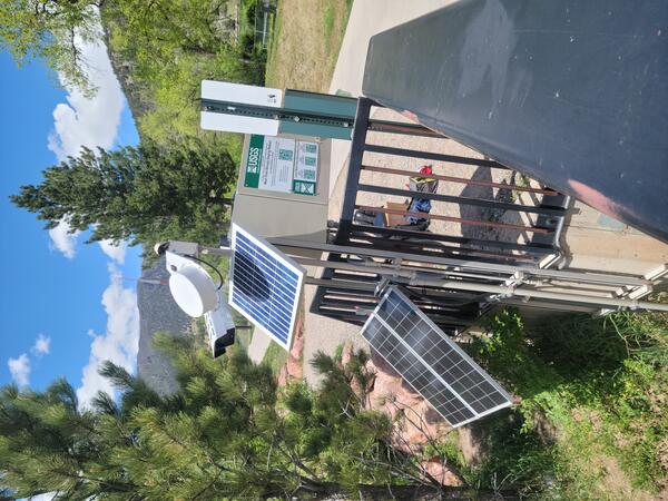
Typical camera installation
Image illustrating typical camera installation, obtained at 393259107194801, Colorado River above Roaring Fork River at Glenwood Springs, CO.
Image illustrating typical camera installation, obtained at 393259107194801, Colorado River above Roaring Fork River at Glenwood Springs, CO.
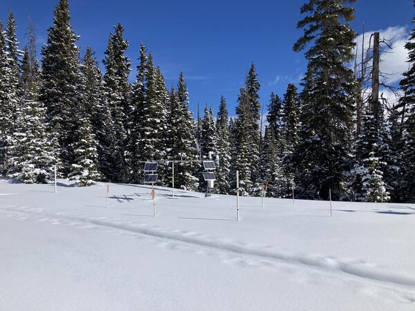
Berthoud Pass under high snow conditions
The Berthoud Pass Meteorological Station, Colorado, in March 2023 with peak snowpack conditions. This site is collocated with an NRCS SNOTEL station to compare sensor capabilities and methods.
The Berthoud Pass Meteorological Station, Colorado, in March 2023 with peak snowpack conditions. This site is collocated with an NRCS SNOTEL station to compare sensor capabilities and methods.

Vertical and horizontal gradients in groundwater level elevations
Vertical and horizontal gradients in groundwater level elevationsGroundwater level elevations within the mine workings (indicated by the red dotted lines) and within crystalline bedrock outside the mine workings (indicated by the blue dotted lines) are substantially different from one another.
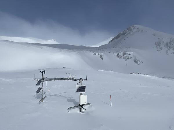
High alpine site at peak snow accumulation
At 12,160 feet, Senator Beck Meteorological Station, Colorado, is one of the higher elevation alpine sites in the network and shows the large amount of snow at these high-altitude catchment environments, as well as sublimation and wind redistribution of snow, a potentially important area to measure for water availability forecasting.
At 12,160 feet, Senator Beck Meteorological Station, Colorado, is one of the higher elevation alpine sites in the network and shows the large amount of snow at these high-altitude catchment environments, as well as sublimation and wind redistribution of snow, a potentially important area to measure for water availability forecasting.

Snow crossing during Eagle Creek site visit
Will McDermott, a physical scientist with the USGS Colorado Water Science Center, working his way across the snow during a site visit at Eagle Creek.
Will McDermott, a physical scientist with the USGS Colorado Water Science Center, working his way across the snow during a site visit at Eagle Creek.

Eagle Creek Site Visit
Will McDermott, a physical scientist with the USGS Colorado Water Science Center, working during site visit to Eagle Creek.
Will McDermott, a physical scientist with the USGS Colorado Water Science Center, working during site visit to Eagle Creek.

Map of South Platte River, Denver, CO
Map showing study reaches and approximate extent of restoration efforts on the South Platte River in Denver, Colorado.
Map showing study reaches and approximate extent of restoration efforts on the South Platte River in Denver, Colorado.
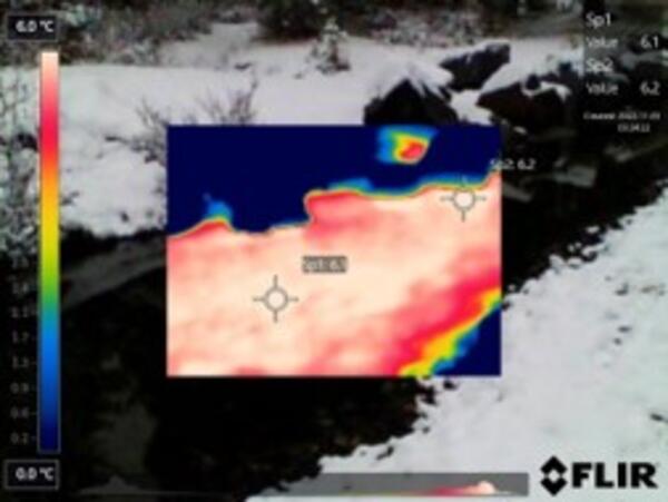
Thermal infrared imaging of groundwater discharge
Because of thermal contrasts between inflowing groundwater and streams, USGS scientists use thermal infrared cameras to identify zones of groundwater discharge, as seen in this photograph.
Because of thermal contrasts between inflowing groundwater and streams, USGS scientists use thermal infrared cameras to identify zones of groundwater discharge, as seen in this photograph.
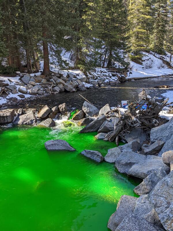
Dye injection into the Slate River, Colorado
Sodium fluorescein dye injection into the Slate River used to measure how much groundwater flows into it.
Sodium fluorescein dye injection into the Slate River used to measure how much groundwater flows into it.
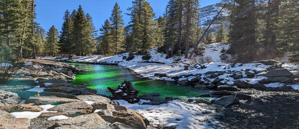
Dye tracer study of the Slate River (Landscape)
USGS scientists injected a non-toxic fluorescent dye into the Slate River to identify zones of groundwater discharge.
USGS scientists injected a non-toxic fluorescent dye into the Slate River to identify zones of groundwater discharge.

Aerial Photo of the South Platte River in Denver, CO
Aerial Photo of the South Platte River in Denver, COAerial photographs of study reaches on the South Platte River in Denver, Colorado.
Aerial Photo of the South Platte River in Denver, CO
Aerial Photo of the South Platte River in Denver, COAerial photographs of study reaches on the South Platte River in Denver, Colorado.

Aerial Photo of the South Platte River in Denver, CO
Aerial Photo of the South Platte River in Denver, COAerial photograph of study reaches on the South Platte River in Denver, Colorado.
Aerial Photo of the South Platte River in Denver, CO
Aerial Photo of the South Platte River in Denver, COAerial photograph of study reaches on the South Platte River in Denver, Colorado.

Colorado River above Roaring Fork River at Glenwood Springs, Colorado
Colorado River above Roaring Fork River at Glenwood Springs, ColoradoContrasting conditions on the Colorado and Roaring Fork Rivers at streamgage 393259107194801, Colorado River above Roaring Fork River at Glenwood Springs, CO.
Colorado River above Roaring Fork River at Glenwood Springs, Colorado
Colorado River above Roaring Fork River at Glenwood Springs, ColoradoContrasting conditions on the Colorado and Roaring Fork Rivers at streamgage 393259107194801, Colorado River above Roaring Fork River at Glenwood Springs, CO.

Map showing helicopter survey area and near Granby, Colo.
Map showing helicopter survey area and near Granby, Colo.Map showing helicopter survey area and near Granby, Colo. Surveys will not occur directly above populated areas. Black circle indicates study area.
Map showing helicopter survey area and near Granby, Colo.
Map showing helicopter survey area and near Granby, Colo.Map showing helicopter survey area and near Granby, Colo. Surveys will not occur directly above populated areas. Black circle indicates study area.

USGS employee, Caleb Schraeder, in cableway above river
USGS employee, Caleb Schraeder, in cableway above riverUSGS employee, Caleb Schraeder, in cableway over the Sacramento River above Bend Bridge near Red Bluff, CA.
USGS employee, Caleb Schraeder, in cableway above river
USGS employee, Caleb Schraeder, in cableway above riverUSGS employee, Caleb Schraeder, in cableway over the Sacramento River above Bend Bridge near Red Bluff, CA.

Yampa River and Steamboat Spring Outflow
The namesake of the City of Steamboat Springs was once a geyser. Now the spring upwells into a large pool before flowing out to the Yampa River.
The namesake of the City of Steamboat Springs was once a geyser. Now the spring upwells into a large pool before flowing out to the Yampa River.