
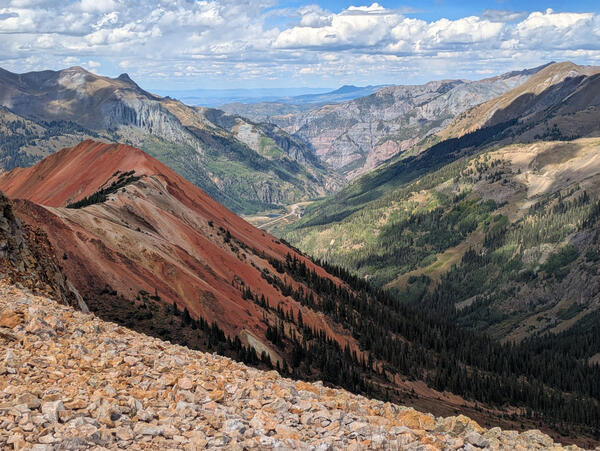
Red Mountain #1 in the San Juan Mountains of Colorado is an example of natural mineral weathering, where the USGS is working to understand metal mobilization processes in mine workings and groundwater.
Images
Images intro.
Filter Total Items: 144
Red Mountain #1
Red Mountain #1 in the San Juan Mountains of Colorado is an example of natural mineral weathering, where the USGS is working to understand metal mobilization processes in mine workings and groundwater.
Map of Upper Colorado River Basin - Integrated Water Availability
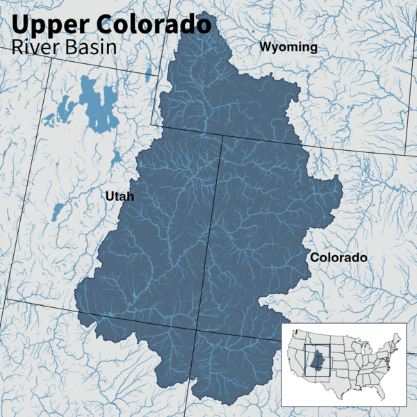
Map of Upper Colorado River Basin - Integrated Water AvailabilityMap of the Upper Colorado River Basin —referred to as an Integrated Water Science (IWS) basins—are intensively monitored study basins representing a wide range of environmental, hydrologic, and landscape settings and human stressors of water resources to improve our understanding of water availability across the Nation.
Map of Upper Colorado River Basin - Integrated Water Availability
Map of Upper Colorado River Basin - Integrated Water AvailabilityMap of the Upper Colorado River Basin —referred to as an Integrated Water Science (IWS) basins—are intensively monitored study basins representing a wide range of environmental, hydrologic, and landscape settings and human stressors of water resources to improve our understanding of water availability across the Nation.
NGWOS Upper Colorado River Basin study area map
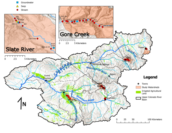
Map of the NGWOS Upper Colorado River Basin study area and the focus study watersheds for studies of groundwater/surface-water connections.
Map of the NGWOS Upper Colorado River Basin study area and the focus study watersheds for studies of groundwater/surface-water connections.
NGWOS site location map
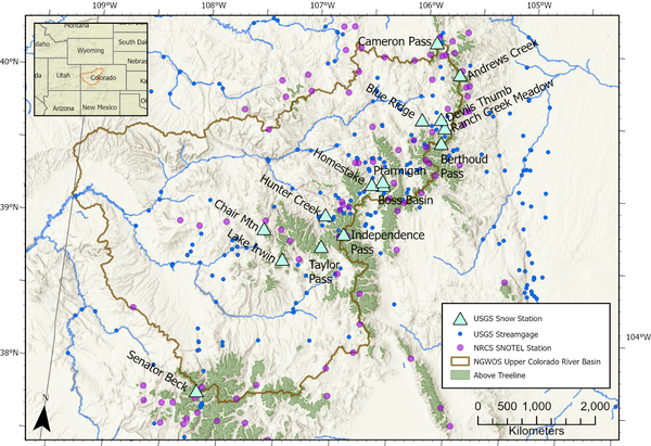
Map of the Upper Colorado River Basin showing locations of USGS snow stations, USGS streamgages, and Natural Resources Conservation Service (NRCS) Snow Telemetry (SNOTEL) stations.
Map of the Upper Colorado River Basin showing locations of USGS snow stations, USGS streamgages, and Natural Resources Conservation Service (NRCS) Snow Telemetry (SNOTEL) stations.
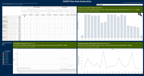
Fountain Creek Watershed Water Quality Trends
The Colorado Water Science Center is conducting a study for the City of Colorado Springs Stormwater Enterprise (SWENT) to analyze trends in Water Quality data. This worksheet provides an interactive means to explore the data available for 5 mainstem sites and 4 tributary sites within the Fountain Creek Watershed.
The Colorado Water Science Center is conducting a study for the City of Colorado Springs Stormwater Enterprise (SWENT) to analyze trends in Water Quality data. This worksheet provides an interactive means to explore the data available for 5 mainstem sites and 4 tributary sites within the Fountain Creek Watershed.

Water Isotope Network map
Map showing the major tritium-monitoring sites in the NGWOS study area of the Upper Colorado River Basin where Water Isotope Network samples of precipitation and streamflow are collected, as well as sites where snowpack samples are collected for comparison to total precipitation.
Map showing the major tritium-monitoring sites in the NGWOS study area of the Upper Colorado River Basin where Water Isotope Network samples of precipitation and streamflow are collected, as well as sites where snowpack samples are collected for comparison to total precipitation.

How groundwater contributes to streamflow
A conceptual diagram of how groundwater storage and flow paths contribute to streamflow. Three key processes are illustrated: the process of infiltration (groundwater recharge), groundwater discharge along faster and slower flow paths to a stream, and variations in groundwater storage in response to wetter years and drought.
A conceptual diagram of how groundwater storage and flow paths contribute to streamflow. Three key processes are illustrated: the process of infiltration (groundwater recharge), groundwater discharge along faster and slower flow paths to a stream, and variations in groundwater storage in response to wetter years and drought.

Map of study reach on East River in Colorado
Map of the study reach between U.S. Geological Survey streamgages 09112200 (East River below Cement Creek near Crested Butte, Colorado) and 09112500 (East River at Almont, Colo.), East River Basin, Colorado.
Map of the study reach between U.S. Geological Survey streamgages 09112200 (East River below Cement Creek near Crested Butte, Colorado) and 09112500 (East River at Almont, Colo.), East River Basin, Colorado.

Colorado River above Roaring Fork River at Glenwood Springs, Colorado
Colorado River above Roaring Fork River at Glenwood Springs, ColoradoContrasting conditions on the Colorado and Roaring Fork Rivers at streamgage 393259107194801, Colorado River above Roaring Fork River at Glenwood Springs, CO.
Colorado River above Roaring Fork River at Glenwood Springs, Colorado
Colorado River above Roaring Fork River at Glenwood Springs, ColoradoContrasting conditions on the Colorado and Roaring Fork Rivers at streamgage 393259107194801, Colorado River above Roaring Fork River at Glenwood Springs, CO.

09110500 East River Near Crested Butte, Colorado
The East River at U.S. Geological Survey streamgage site 09110500 (East River Near Crested Butte, Colorado.)
The East River at U.S. Geological Survey streamgage site 09110500 (East River Near Crested Butte, Colorado.)

Irrigation ditch in the East River Basin, Colorado
Irrigation ditch in the East River Basin, ColoradoPhoto of irrigation ditch flowing through a pasture in the East River Basin, Colorado.
Irrigation ditch in the East River Basin, Colorado
Irrigation ditch in the East River Basin, ColoradoPhoto of irrigation ditch flowing through a pasture in the East River Basin, Colorado.

South Platte near Overland Golf Course
USGS employees surveying on the South Platte near Overland Golf Course (February 2024) using RC boat and sonar.
USGS employees surveying on the South Platte near Overland Golf Course (February 2024) using RC boat and sonar.

South Platte near Elitch Gardens
USGS employee surveying on the South Platte near Elitch Gardens in February, 2024.
USGS employee surveying on the South Platte near Elitch Gardens in February, 2024.

ADCP setup on the South Platte near Elitch Gardens
ADCP setup on the South Platte near Elitch GardensUSGS employees setting up an ADCP survey on the South Platte River near Elitch Gardens in Denver, CO.
ADCP setup on the South Platte near Elitch Gardens
ADCP setup on the South Platte near Elitch GardensUSGS employees setting up an ADCP survey on the South Platte River near Elitch Gardens in Denver, CO.

USGS employee, Caleb Schraeder, standing in snow- and ice-covered creek
USGS employee, Caleb Schraeder, standing in snow- and ice-covered creekUSGS employee, Caleb Schraeder, standing in snow and ice covered South Clear Creek above Lower Cabin Creek Reservoir near Georgetown, CO.
USGS employee, Caleb Schraeder, standing in snow- and ice-covered creek
USGS employee, Caleb Schraeder, standing in snow- and ice-covered creekUSGS employee, Caleb Schraeder, standing in snow and ice covered South Clear Creek above Lower Cabin Creek Reservoir near Georgetown, CO.

High elevation precipitation collector
The Water Isotope Network precipitation collector at U.S. Geological Survey site 385303107060301 Lake Irwin Meteorological Station near Ruby Anthracite Creek, Colorado in October 2023.
The Water Isotope Network precipitation collector at U.S. Geological Survey site 385303107060301 Lake Irwin Meteorological Station near Ruby Anthracite Creek, Colorado in October 2023.

Conceptual model of groundwater site
Insights gained from stable isotopes and environmental tracers in this study allow a conceptual model to be built that provides information pertinent to groundwater mixing and transport, sulfide oxidation mechanisms, and timeframes of remediation. This conceptual model of the site (not to scale) is based on hydrologic and geochemical data.
Insights gained from stable isotopes and environmental tracers in this study allow a conceptual model to be built that provides information pertinent to groundwater mixing and transport, sulfide oxidation mechanisms, and timeframes of remediation. This conceptual model of the site (not to scale) is based on hydrologic and geochemical data.

Water quality sampling at Monument Creek, CO
U.S. Geological Survey (USGS) hydrologic technician Lauren Castanon making a streamflow measurement during a water quality sampling visit at USGS site Monument Creek above Northgate Blvd at U.S. Air Force Academy, Colorado 07103780.
U.S. Geological Survey (USGS) hydrologic technician Lauren Castanon making a streamflow measurement during a water quality sampling visit at USGS site Monument Creek above Northgate Blvd at U.S. Air Force Academy, Colorado 07103780.

Researchers inject fluorescein dye into Lake Fork Creek, Colorado
Researchers inject fluorescein dye into Lake Fork Creek, ColoradoResearchers inject fluorescein dye into Lake Fork Creek, Colorado, in August 2023. This study aims to trace water flow from the historic Sugarloaf mining district into the creek.

Douglas County Groundwater Network Map
Location of groundwater-level monitoring network wells and producing aquifer, Douglas County, Colorado.
Location of groundwater-level monitoring network wells and producing aquifer, Douglas County, Colorado.

South Platte River at Englewood, CO - Hydrograph
Streamflow duration hydrograph for the South Platte River at Englewood, Co. Hydrographs and other information are available at the USGS WaterWatch website.
Streamflow duration hydrograph for the South Platte River at Englewood, Co. Hydrographs and other information are available at the USGS WaterWatch website.