
The Water Isotope Network precipitation collector at U.S. Geological Survey site 395811105480401 Devils Thumb Meteorological Station near Fraser, Colorado, in September 2020.
Images
Images intro.
Filter Total Items: 142

Lower elevation precipitation collector
The Water Isotope Network precipitation collector at U.S. Geological Survey site 395811105480401 Devils Thumb Meteorological Station near Fraser, Colorado, in September 2020.

Captain Jack Superfund Site, Boulder County, Colorado
Captain Jack Superfund Site, Boulder County, ColoradoThe Captain Jack site is located in mountainous terrain northwest of Boulder, Colorado. Here the terrain is visible behind an old train track leading into a mine adit.
Location: Captain Jack Superfund site, Boulder County, Colorado

Fountain Creek near Manitou Spring, Colorado
Image of a streamflow measurement site on Fountain Creek near Manitou Springs, Colorado.
Image of a streamflow measurement site on Fountain Creek near Manitou Springs, Colorado.

Calcite Precipitation at Captain Jack Superfund Site, Boulder County, CO
Calcite Precipitation at Captain Jack Superfund Site, Boulder County, COInteractions between water and minerals in the subsurface (including efflorescent sulfate salts and calcite such as this sample from the Big Five adit) are a primary control on water quality in mining environments. Research is evaluating the importance of these minerals in generating acid mine drainage.

GNSS Surveying Equipment near Non-Potable Reservoir 1
GNSS Surveying Equipment near Non-Potable Reservoir 1Real-Time Kinematic Global Navigation Satellite Systems (GNSS) surveying equipment near Non-Potable Reservoir 1
GNSS Surveying Equipment near Non-Potable Reservoir 1
GNSS Surveying Equipment near Non-Potable Reservoir 1Real-Time Kinematic Global Navigation Satellite Systems (GNSS) surveying equipment near Non-Potable Reservoir 1

Ice Lake at dusk, looking north from the main outlet structure
Ice Lake at dusk, looking north from the main outlet structureIce Lake at dusk, looking north from the main outlet structure
Ice Lake at dusk, looking north from the main outlet structure
Ice Lake at dusk, looking north from the main outlet structureIce Lake at dusk, looking north from the main outlet structure

Bathymetric surveying equipment at Non-Potable Reservoir 2
Bathymetric surveying equipment at Non-Potable Reservoir 2Research vessel with bathymetric surveying equipment Non-Potable Reservoir 2
Bathymetric surveying equipment at Non-Potable Reservoir 2
Bathymetric surveying equipment at Non-Potable Reservoir 2Research vessel with bathymetric surveying equipment Non-Potable Reservoir 2

Research vessel on Kettle Lake 3
Research vessel with bathymetric surveying equipment andU.S. Geological Survey hydrologist on Kettle Lake 3.
Research vessel with bathymetric surveying equipment andU.S. Geological Survey hydrologist on Kettle Lake 3.

Looking southwest from the north side of Kettle Lake 2
Looking southwest from the north side of Kettle Lake 2Looking southwest from the north side of Kettle Lake 2
Looking southwest from the north side of Kettle Lake 2
Looking southwest from the north side of Kettle Lake 2Looking southwest from the north side of Kettle Lake 2

North Taylor Creek, Wet Mountain Valley, Colorado
Image of North Taylor Creek in Wet Mountain Valley, Colorado prior to completion of a surface-water discharge measurement.
Image of North Taylor Creek in Wet Mountain Valley, Colorado prior to completion of a surface-water discharge measurement.

Aquifer testing in Wet Mountain Valley, Colorado
Photo of equipment for slug test at aquifer testing site in Colorado. The Rocky Mountains are visible in the background.
Photo of equipment for slug test at aquifer testing site in Colorado. The Rocky Mountains are visible in the background.
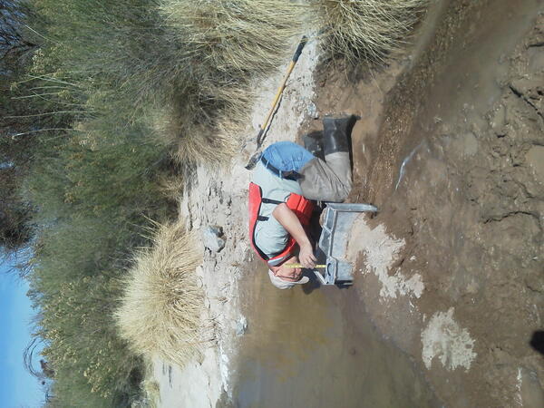
Tony Carson recording flume measurement
Tony Carson, with the Colorado Water Science Center, pays careful attention to detail as he records flume measurements.
Tony Carson, with the Colorado Water Science Center, pays careful attention to detail as he records flume measurements.

Illinois Gulch near Breckenridge, Colorado
Two synoptic sampling campaigns were conducted near Breckenridge, Colorado, to quantify metal loading to Illinois Gulch, a tributary of the Blue River.
Two synoptic sampling campaigns were conducted near Breckenridge, Colorado, to quantify metal loading to Illinois Gulch, a tributary of the Blue River.

NAAMDRC - A microscopic picture of a Dytiscus insect from the AXL lab
NAAMDRC - A microscopic picture of a Dytiscus insect from the AXL labA microscopic picture of a Dytiscus insect from the AXL lab at the Fort Collins Science Center.
NAAMDRC - A microscopic picture of a Dytiscus insect from the AXL lab
NAAMDRC - A microscopic picture of a Dytiscus insect from the AXL labA microscopic picture of a Dytiscus insect from the AXL lab at the Fort Collins Science Center.

USGS personnel collecting bathymetry data.
USGS research vessel with Teledyne Odom Hydrographic ES3PT–M integrated multibeam echo sounder and motion sensor submerged on the port side, and Trimble SPS461 GPS receivers mounted on each side of vessel.
USGS research vessel with Teledyne Odom Hydrographic ES3PT–M integrated multibeam echo sounder and motion sensor submerged on the port side, and Trimble SPS461 GPS receivers mounted on each side of vessel.

CWSC Bathymetry at Clear Creek Reservoir
USGS research vessel collecting bathymetry data at Clear Creek Reservoir.
USGS research vessel collecting bathymetry data at Clear Creek Reservoir.

Sediment Sampling at A72
Animas River downstream from Silverton, Colorado, showing right and left bank areas where streambed sediment sample was collected near USGS stream gage at site A72 (USGS site ID 09359020). Latitude 37.789964, Longitude -107.667394.
Animas River downstream from Silverton, Colorado, showing right and left bank areas where streambed sediment sample was collected near USGS stream gage at site A72 (USGS site ID 09359020). Latitude 37.789964, Longitude -107.667394.

Measuring pH
Measuring pH at the outlet of the fourth settling pond downstream from the North Fork Cement Creek. Latitude 37.894451, Longitude -107.64763.
Measuring pH at the outlet of the fourth settling pond downstream from the North Fork Cement Creek. Latitude 37.894451, Longitude -107.64763.

USGS Gage 09358000
USGS stream Gage (USGS site ID 09358000) on Animas River upstream from Silverton and Cement Creek. Latitude 37.811131, Longitude -107.659213.
USGS stream Gage (USGS site ID 09358000) on Animas River upstream from Silverton and Cement Creek. Latitude 37.811131, Longitude -107.659213.

Animas River at A72
Animas River downstream from Silverton, Colorado showing cableway for USGS stream gage at site A72 (USGS site ID 09359020). Latitude 37.789964, Longitude -107.667394.
Animas River downstream from Silverton, Colorado showing cableway for USGS stream gage at site A72 (USGS site ID 09359020). Latitude 37.789964, Longitude -107.667394.

Animas River Downstream
Animas River downstream from Silverton Colorado, looking upstream toward town of Silverton. Confluence of Animas River and Mineral Creek near center of photograph. Confluence of Cement Creek and Animas River near upstream area of the town of Silverton. Photo taken from Highway 550 heading to Durango.
Animas River downstream from Silverton Colorado, looking upstream toward town of Silverton. Confluence of Animas River and Mineral Creek near center of photograph. Confluence of Cement Creek and Animas River near upstream area of the town of Silverton. Photo taken from Highway 550 heading to Durango.