
Hazards
Hazards
Filter Total Items: 8
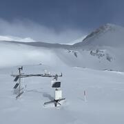
Next Generation Water Observing System (NGWOS) Snow Hydrology Monitoring Network in the Upper Colorado River Basin
Representative observations of snowpack conditions are vital for informing water availability assessments and modeling in snow dominated regions of the western United States. The U.S. Geological Survey (USGS) established a snow hydrology monitoring network in 2021 with the objective of providing high-quality, representative, and publicly available data on snowpack, soil moisture, and...

Camera Installations Collecting Hydrologic Imagery at USGS Monitoring Locations in Colorado
The Colorado Water Science Center Network Integration and Science Innovation team has focused on installing cameras at U.S. Geological Survey (USGS) monitoring locations for situational and observational awareness of conditions at streams, rivers, and lakes in Colorado. Several USGS monitoring locations have been configured with cellular modems and network cameras to obtain still and video imagery...

Peak Discharge, Flood Frequency, and Peak Stage of Floods
The U.S. Geological Survey (USGS), in cooperation with the Colorado Department of Transportation, determined the peak discharge, annual exceedance probability (flood frequency), and peak stage of two floods that took place on Big Cottonwood Creek at U.S. Highway 50 near Coaldale, Colorado (hereafter referred to as “Big Cottonwood Creek site”), on August 23, 2016, and on Fountain Creek below U.S...

Fort Morgan Flood Inundation Mapping Study
In 2017, the U.S. Geological Survey (USGS), in cooperation with the Colorado Water Conservation Board (CWCB), studied floods in the historic record to produce a library of flood-inundation maps for the South Platte River at Fort Morgan, Colorado.

Precipitation and Streamgage Flood Warning System
Rainfall amounts associated with the September 2013 Colorado Floods exceeded 15 inches in some locations and resulted in significant flooding along the Front Range (Hydrometeorological Design Studies Center, 2013). These events resulted in streamflows that compromised a variety of transportation structures such as bridges and culverts and roadways. By coupling the National Oceanic and Atmospheric...

Eastern Colorado Crest-Stage Gage Network
The U.S. Geological Survey StreamStats program can be used to estimate the magnitude of various annual exceedance probability floods such as the 50-year or 100-year floods at locations where no streamgage data are available. In eastern Colorado where few streamgages exist, the regional-flood equations used in StreamStats have large uncertainties. In order to reduce these uncertainties, the U.S...
DEFEnS - DEbris and Flood Early warNing System
The Waldo Canyon wildfire burned more than 18,000 acres within a perimeter of more than 19,000 acres. In response to the July and August 2013 floods in the Waldo Canyon watershed and in collaboration with the Colorado Department of Transportation (CDOT) and the U.S. Geological Survey developed a warning system for Waldo Canyon associated with a wildfire burn scar, which are at risk to debris and...

Flood Database for Colorado
The U.S. Geological Survey, in cooperation with the Colorado Department of Transportation, created a Web-based geodatabase for information on floods from 1867 through water year 2015 and information on paleofloods occurring in the past 5,000 to 10,000 years. The geodatabase was created using Environmental Systems Research Institute ArcGIS JavaScript Application Programing Interface. Engineers...