
Model Development
Model Development
Filter Total Items: 7
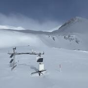
Next Generation Water Observing System (NGWOS) Snow Hydrology Monitoring Network in the Upper Colorado River Basin
Representative observations of snowpack conditions are vital for informing water availability assessments and modeling in snow dominated regions of the western United States. The U.S. Geological Survey (USGS) established a snow hydrology monitoring network in 2021 with the objective of providing high-quality, representative, and publicly available data on snowpack, soil moisture, and...

Agricultural Return Flows in the Upper Gunnison River Basin
Canals and ditches divert water from streams in the Upper Gunnison River Basin, Colorado, to irrigate agricultural fields. In some areas, irrigation water that percolates below the root zone can locally recharge groundwater and later return to streams through the subsurface, which can extend streamflow outside of the snowmelt runoff season. Understanding the timing and quantity of agricultural...

Isotopic and environmental tracers for improved understanding of geochemical and hydrologic processes occurring near flooded mine workings
Draining mine tunnels contribute metals and acidity to streams throughout the western United States. One remediation strategy that is increasing in usage is the emplacement of hydraulic bulkheads to impound water within the subsurface. Potential secondary effects of bulkhead usage are difficult to quantify however because of the inherent complexity of many mountain hydrologic systems. In...

Hydrology of an Artesian Aquifer near Manitou Springs, Colorado
The area surrounding Manitou Springs, Colorado is host to numerous bedrock springs, which help to support the local economy through tourist visitation. Although many springs previously flowed directly to the surface, most of the “springs” in the area are now more strictly classified as flowing artesian wells completed in the Manitou Formation, a cavernous intermixed limestone and dolomite, which...

One-Dimensional Transport with Equilibrium Chemistry (OTEQ): A Reactive Transport Model for Streams and Rivers
OTEQ is a mathematical simulation model used to characterize the fate and transport of waterborne solutes in streams and rivers. The model is formed by coupling a solute transport model with a chemical equilibrium submodel. The solute transport model is based on OTIS, a model that considers the physical processes of advection, dispersion, lateral inflow, and transient storage. The equilibrium...

One-Dimensional Transport with Inflow and Storage (OTIS): A Solute Transport Model for Streams and Rivers
OTIS is a mathematical simulation model used to characterize the fate and transport of water-borne solutes in streams and rivers. The governing equation underlying the model is the advection-dispersion equation with additional terms to account for transient storage, lateral inflow, first-order decay, and sorption. This equation and the associated equations describing transient storage and sorption...

Groundwater Model Development
MODFLOW is the USGS's modular hydrologic model. MODFLOW is considered an international standard for simulating and predicting groundwater conditions and groundwater/surface-water interactions. Originally developed and released solely as a groundwater-flow simulation code when first published in 1984, MODFLOW's modular structure has provided a robust framework for integration of additional...