
Modeling
Modeling
Filter Total Items: 13
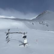
Next Generation Water Observing System (NGWOS) Snow Hydrology Monitoring Network in the Upper Colorado River Basin
Representative observations of snowpack conditions are vital for informing water availability assessments and modeling in snow dominated regions of the western United States. The U.S. Geological Survey (USGS) established a snow hydrology monitoring network in 2021 with the objective of providing high-quality, representative, and publicly available data on snowpack, soil moisture, and...

Agricultural Return Flows in the Upper Gunnison River Basin
Canals and ditches divert water from streams in the Upper Gunnison River Basin, Colorado, to irrigate agricultural fields. In some areas, irrigation water that percolates below the root zone can locally recharge groundwater and later return to streams through the subsurface, which can extend streamflow outside of the snowmelt runoff season. Understanding the timing and quantity of agricultural...

Colorado River Headwaters, Water Isotope Network
Water availability is controlled by processes that can be hard to measure, like the process of groundwater discharging from a streambed that becomes streamflow. Naturally occurring, radioactive and stable (non-radioactive) isotopes can help trace those processes, particularly the isotopes of hydrogen and oxygen that are part of the water molecule. Tritium, the radioactive isotope of hydrogen, has...

Isotopic and environmental tracers for improved understanding of geochemical and hydrologic processes occurring near flooded mine workings
Draining mine tunnels contribute metals and acidity to streams throughout the western United States. One remediation strategy that is increasing in usage is the emplacement of hydraulic bulkheads to impound water within the subsurface. Potential secondary effects of bulkhead usage are difficult to quantify however because of the inherent complexity of many mountain hydrologic systems. In...

Hydrology of an Artesian Aquifer near Manitou Springs, Colorado
The area surrounding Manitou Springs, Colorado is host to numerous bedrock springs, which help to support the local economy through tourist visitation. Although many springs previously flowed directly to the surface, most of the “springs” in the area are now more strictly classified as flowing artesian wells completed in the Manitou Formation, a cavernous intermixed limestone and dolomite, which...

Hydrology of and potential for groundwater storage in the alluvial aquifer in the Wet Mountain Valley, Colorado
Hydrologic analysis of the alluvial aquifer in the Wet Mountain Valley has been undertaken using synoptic streamflow and groundwater-level elevation measurements, aquifer tests, water-quality sampling and data analysis, and numerical groundwater-flow modeling. These datasets together provide an encompassing view of the interconnected water resources in the area and allow for quantitative...

Lower Yampa Streamflow and Sediment Modeling
Water from the Yampa River basin continues to be sought for a number of municipal, industrial, and energy uses. Water development in the Yampa River basin will alter the streamflow regime and, consequently, will lead to changes in the transport and storage of suspended and bedload sediment. Changes in the Yampa River sediment budget could lead to changes in channel geometry, riparian vegetation...
Numerical simulation of groundwater flow in the Lost Creek Designated Groundwater Basin, Weld and Adams Counties, Colorado
The Lost Creek Designated Ground Water Basin (LCDGWB) is an important alluvial aquifer for water supply in northeastern Colorado. Increased demand for withdrawals from the LCDGWB has led to a concern about the long-term sustainability of the basin’s ground-water resources. A numerical ground-water flow model developed using an early version of MODFLOW exists for the LCDGWB. A review and update of...
Simulated Effects of Proposed Southern Delivery System Alternatives on Hydrodynamics and Water Quality of Pueblo Reservoir Using a Two-Dimensional Hydrodynamic and Water-Quality Model, Pueblo, Colorado
Pueblo Reservoir is one of southeastern Colorado's most valuable water resources. The reservoir provides irrigation, municipal, and industrial water to various entities throughout the region. The reservoir also provides flood control, recreational activities, sport fishing, and wildlife enhancement to the region. The Bureau of Reclamation is working to meet its goal to issue a Final Environmental...

Groundwater Availability Analysis of the Denver Groundwater Basin
The Denver Basin aquifer system is a critical water resource for growing municipal, industrial, and domestic uses along the semiarid Front Range urban corridor of Colorado. The confined bedrock aquifer system is located along the eastern edge of the Rocky Mountain Front Range where the mountains meet the Great Plains physiographic province. Mining, transportation, agricultural, and urban...
Numerical simulation of the cumulative effects of land-use change and aggregate mines on ground-water flow and wetlands along the South Platte River, Brighton to Fort Lupton, Colorado
The South Platte River valley between the City of Brighton in Adams County and the town of Fort Lupton in Weld County, Colorado, contains many wetland areas that provide habitat for wildlife in the Front Range Urban Corridor. The extent of aggregate mining along this reach of the South Platte River valley continues to increase as the demand for aggregate grows in response to urban development. The...
Stochastic Modeling of Effects that the Sulphur Gulch Reservoir May Have on Colorado River Water Quality near Grand Junction, Colorado
Sulphur Gulch, a new reservoir proposed to be located about 25 miles east of Grand Junction, Colorado, on a tributary to the Colorado River that drains the Sulphur Gulch watershed between De Beque and Cameo, Colorado. The primary use of the Sulphur Gulch Reservoir would be to provide the Colorado River with up to 5,412.5 acre-feet of late-season water in support of the Endangered Fish Recovery...