
New Technologies
New Technologies
Filter Total Items: 7
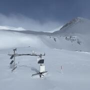
Next Generation Water Observing System (NGWOS) Snow Hydrology Monitoring Network in the Upper Colorado River Basin
Representative observations of snowpack conditions are vital for informing water availability assessments and modeling in snow dominated regions of the western United States. The U.S. Geological Survey (USGS) established a snow hydrology monitoring network in 2021 with the objective of providing high-quality, representative, and publicly available data on snowpack, soil moisture, and...

Camera Installations Collecting Hydrologic Imagery at USGS Monitoring Locations in Colorado
The Colorado Water Science Center Network Integration and Science Innovation team has focused on installing cameras at U.S. Geological Survey (USGS) monitoring locations for situational and observational awareness of conditions at streams, rivers, and lakes in Colorado. Several USGS monitoring locations have been configured with cellular modems and network cameras to obtain still and video imagery...

Streamflows at Baca and Alamosa National Wildlife Refuges using Non-Contact Technology
The goal of this study is to design, install, and operationalize non-contact radar monitoring to measure streamflow at two sites at National Wildlife Refuges (NWRs) in the San Luis Valley, Colorado. Where traditional monitoring equipment in a stream channel is difficult to operate and maintain, non-contact radar technology is a solution that provides more cost-effective and accurate continuous...

Incipient Bed-Movement and Flood-Frequency Analysis Using Hydrophones to Estimate Flushing Flows on the Upper Colorado River, Colorado, 2019
In an effort to better understand sediment movement and its relation to flow regimes of the Upper Colorado River in Colorado, in 2019, the U.S. Geological Survey, in cooperation with the Upper Colorado River Wild and Scenic Stakeholder Group, studied the magnitude and recurrence interval of streamflow (discharge) needed to initiate bed movement of gravel-sized and finer sediment in a segment of...

Remotely Sensed Discharge
River discharge is an important component of the water cycle, and an accurate accounting of streamflow can be accomplished by monitoring the spatial and temporal variations in river discharge. The U.S. Geological Survey is actively pursuing remote-sensing platforms to compute river discharge using a combination of satellite-, high altitude-, drone-, and fixed-based platforms to directly measure...

Radar on Drones
Small, Unmanned Aircraft Systems (sUAS) or drones can be used to monitor extreme flows in basins that (1) respond quickly to precipitation events, (2) are not gaged, (3) are located in terrain that restricts access and equipment deployments, and (4) are altered by events such as wildfires.
SWOT - Surface Water and Ocean Topography
Satellite altimetry associated with the Surface Water and Ocean Topography (SWOT) mission offers a solution for measuring (1) river stage and slope, (2) water surface area including mean channel width and (3) derivatives such as river discharge. The measurements can be used to track changes in these variables and provide an accounting of the Earth's fresh-water bodies from space at the reach scale...