
USGS EROS Archive - Landsat Legacy - Tri-Decadal Landsat Orthorectified ETM+ Pan-sharpened Single Scenes
Tri-Decadal Global Landsat Orthorectified single scene data collection consisting of a global set of high-quality, relatively cloud-free orthorectified ETM+ Pan-sharpened scenes from Landsat 7.
Back to Tri-Decadal Landsat Orthorectified Single Scenes
Tri-Decadal Landsat Orthorectified Single Scenes - ETM+ Pan-Sharpened
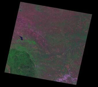
These data products consist of pan-sharpened versions of the ETM+ scenes above. The pan-sharpening process involved a resolution merging process, which allows the fusion of the higher-resolution panchromatic band (8) with selected lower-resolution multispectral bands (7,4,2) to create a higher-resolution ("pan-sharpened") color image. The Tri-Decadal Global Landsat Orthorectified single scene data collection selection consists of approximately 8,700 ETM+ Pan Sharpened (Landsat 7) images.
Processing Parameters
All Tri-Decadal Global Landsat Orthorectified data products have been pre-processed according to a standardized set of processing parameters.
| ETM+ Pan-Sharpened | |
|---|---|
| Level of processing | Terrain corrected |
| Number of bands (Band designations) | 3 (bands 7,4,2) |
| Resolution | 14.25 m |
| Projection | Universal Transverse Mercator (UTM) |
| Datum | WGS84 |
| Resampling | Cubic Convolution |
| Format | GeoTIFF |
Coverage Maps
Coverage Maps indicating the availability of ETM+ Pan-Sharpened products are available for download.
Access Data
Tri-Decadal Global Landsat Orthorectified ETM+ Pan Sharpenedsingle scene data can be searched and downloaded from EarthExplorer. The collections are located under the Landsat Legacy category.
Digital Object Identifier (DOI)
Below are other science projects associated with this product.

USGS EROS Archive - Landsat Legacy - Tri-Decadal Landsat Orthorectified ETM+ Single Scenes

USGS EROS Archive - Landsat Legacy - Tri-Decadal Landsat Orthorectified Systematic Correction Single Scenes

USGS EROS Archive - Landsat Legacy - Tri-Decadal Landsat Orthorectified MSS Single Scenes

USGS EROS Archive - Landsat Legacy - Tri-Decadal Landsat Orthorectified TM Single Scenes

USGS EROS Archive - Landsat Legacy - Tri-Decadal Landsat Orthorectified Single Scenes

USGS EROS Archive - Landsat Legacy - Tri-Decadal Landsat Orthorectified Mosaics
Tri-Decadal Global Landsat Orthorectified single scene data collection consisting of a global set of high-quality, relatively cloud-free orthorectified ETM+ Pan-sharpened scenes from Landsat 7.
Back to Tri-Decadal Landsat Orthorectified Single Scenes
Tri-Decadal Landsat Orthorectified Single Scenes - ETM+ Pan-Sharpened
These data products consist of pan-sharpened versions of the ETM+ scenes above. The pan-sharpening process involved a resolution merging process, which allows the fusion of the higher-resolution panchromatic band (8) with selected lower-resolution multispectral bands (7,4,2) to create a higher-resolution ("pan-sharpened") color image. The Tri-Decadal Global Landsat Orthorectified single scene data collection selection consists of approximately 8,700 ETM+ Pan Sharpened (Landsat 7) images.
Processing Parameters
All Tri-Decadal Global Landsat Orthorectified data products have been pre-processed according to a standardized set of processing parameters.
| ETM+ Pan-Sharpened | |
|---|---|
| Level of processing | Terrain corrected |
| Number of bands (Band designations) | 3 (bands 7,4,2) |
| Resolution | 14.25 m |
| Projection | Universal Transverse Mercator (UTM) |
| Datum | WGS84 |
| Resampling | Cubic Convolution |
| Format | GeoTIFF |
Coverage Maps
Coverage Maps indicating the availability of ETM+ Pan-Sharpened products are available for download.
Access Data
Tri-Decadal Global Landsat Orthorectified ETM+ Pan Sharpenedsingle scene data can be searched and downloaded from EarthExplorer. The collections are located under the Landsat Legacy category.
Digital Object Identifier (DOI)
Below are other science projects associated with this product.
USGS EROS Archive - Landsat Legacy - Tri-Decadal Landsat Orthorectified ETM+ Single Scenes
USGS EROS Archive - Landsat Legacy - Tri-Decadal Landsat Orthorectified Systematic Correction Single Scenes
USGS EROS Archive - Landsat Legacy - Tri-Decadal Landsat Orthorectified MSS Single Scenes
USGS EROS Archive - Landsat Legacy - Tri-Decadal Landsat Orthorectified TM Single Scenes
USGS EROS Archive - Landsat Legacy - Tri-Decadal Landsat Orthorectified Single Scenes