
How Much Snow for Colorado River Flow?
Historic lows in Colorado River reservoirs emphasize the critical role of snowpack. This research further refines understanding of precipitation in the Colorado River Basin, a critical water resource.
Historic droughts in the Colorado River Basin are fueled by reduced mountain snowpack, a crucial water source for reservoirs and supply, making snow-dominated alpine headwaters vital water resource indicators.
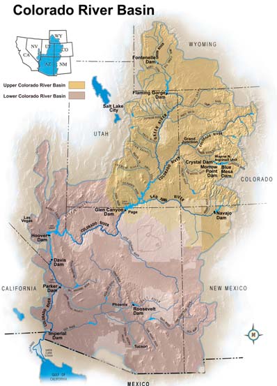

Mountain snowpack constitutes ~80% of Upper Colorado River flow that is vulnerable to decline. However, whether we are reaching long-term aridification, or variable drought, remains uncertain because precipitation is highly variable.
To link the present to long-term baselines of the past, we leveraged observational data with tree-rings and lake sediments from alpine watersheds within the Colorado Rocky Mountains. Lake sediments capture long-term hydroclimatic variability, while high-frequency observations focus on short-term changes. Tree-ring data bridges both timescales, linking observations and proxy records.

We recognized an opportunity to use a unique 20-year USGS dataset of meteorology, hydrology, and water isotope tracers in the Loch Vale watershed at Rocky Mountain National Park's Andrews Meadow.
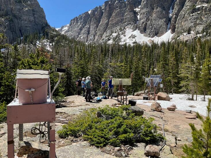
The USGS analyzes water isotopes from Andrews Creek, spring discharge, snowpack, and precipitation samples collected by the National Atmospheric Deposition Program (NADP).

Stable isotope ratios of water track hydroclimatic processes and are preserved in tree rings and lake sediments.

To better understand past hydroclimatic extremes using climate-isotope relationships, we must reconcile differences between high-frequency observations and low-frequency lake sediment data.
20 years of annual tree growth, ~10cm in length, was used to construct an annual isotope record that was statistically compared with annual averages of hydroclimate and water isotopes.


Developing proxy records from near surface lake sediments requires specialized coring equipment, to prevent mixing the delicate watery mud, and careful sampling in the field.

The past 150 years of lake sediment accumulates in 35cm to construct a multi-annual isotope record that was compared with the 20-year annual tree-ring record.

The past ~10,000 years of lake sediment, 350cm in length, was used to construct a decade-to-century isotope record that was compared with the 20-year annual tree-ring record.

The long-term sediment records document past wet and dry extremes linked to seasonal precipitation changes that are strongly influenced by North Pacific controls, like El Niño.

A major finding is that the sediment record directly compares with the tree-rings that are shown to track historic wet and dry extremes. This confirms the method’s feasibility for linking sediment records to discharge.

This research demonstrates the value of combining USGS hydrologic monitoring with geologic records.
By improving our understanding of Colorado River flows caused by precipitation changes, we can better understand future extremes, which enhances our ability to assess drought and aridification for vital water resources.

Historic lows in Colorado River reservoirs emphasize the critical role of snowpack. This research further refines understanding of precipitation in the Colorado River Basin, a critical water resource.
Historic droughts in the Colorado River Basin are fueled by reduced mountain snowpack, a crucial water source for reservoirs and supply, making snow-dominated alpine headwaters vital water resource indicators.
Mountain snowpack constitutes ~80% of Upper Colorado River flow that is vulnerable to decline. However, whether we are reaching long-term aridification, or variable drought, remains uncertain because precipitation is highly variable.
To link the present to long-term baselines of the past, we leveraged observational data with tree-rings and lake sediments from alpine watersheds within the Colorado Rocky Mountains. Lake sediments capture long-term hydroclimatic variability, while high-frequency observations focus on short-term changes. Tree-ring data bridges both timescales, linking observations and proxy records.
We recognized an opportunity to use a unique 20-year USGS dataset of meteorology, hydrology, and water isotope tracers in the Loch Vale watershed at Rocky Mountain National Park's Andrews Meadow.
The USGS analyzes water isotopes from Andrews Creek, spring discharge, snowpack, and precipitation samples collected by the National Atmospheric Deposition Program (NADP).
Stable isotope ratios of water track hydroclimatic processes and are preserved in tree rings and lake sediments.
To better understand past hydroclimatic extremes using climate-isotope relationships, we must reconcile differences between high-frequency observations and low-frequency lake sediment data.
20 years of annual tree growth, ~10cm in length, was used to construct an annual isotope record that was statistically compared with annual averages of hydroclimate and water isotopes.
Developing proxy records from near surface lake sediments requires specialized coring equipment, to prevent mixing the delicate watery mud, and careful sampling in the field.
The past 150 years of lake sediment accumulates in 35cm to construct a multi-annual isotope record that was compared with the 20-year annual tree-ring record.
The past ~10,000 years of lake sediment, 350cm in length, was used to construct a decade-to-century isotope record that was compared with the 20-year annual tree-ring record.
The long-term sediment records document past wet and dry extremes linked to seasonal precipitation changes that are strongly influenced by North Pacific controls, like El Niño.
A major finding is that the sediment record directly compares with the tree-rings that are shown to track historic wet and dry extremes. This confirms the method’s feasibility for linking sediment records to discharge.
This research demonstrates the value of combining USGS hydrologic monitoring with geologic records.
By improving our understanding of Colorado River flows caused by precipitation changes, we can better understand future extremes, which enhances our ability to assess drought and aridification for vital water resources.