
Hydrogeologic-Framework Mapping - Long Island, New York
Long Island is underlain by unconsolidated Holocene deposits, glacial deposits of Pleistocene age, and coastal-plain deposits of Late Cretaceous age. These sediments consist of gravel, sand, silt, and clay underlain by crystalline bedrock of early Paleozoic age (figure 2b). The bedrock is relatively impermeable, and forms the base of the groundwater-flow system on Long Island. The geologic and hydrologic units underlying Long Island have been studied and characterized by the USGS since the early 1900s. Much of this earlier work has been synthesized by Smolensky and others (1990); however, in this previous work, there continues to be uncertainty in areas of complex hydrogeology especially along the northern parts of Long Island where extensive glacial erosion and deposition has not been adequately mapped.
Approach
A synthesis of all existing lithologic data collected since the last framework compilation (Smolensky and others, 1990) is being augmented with a network of new observation wells that are being drilled in areas of complex hydrogeology to better define and reduce uncertainties in the hydrogeologic framework and to provide additional information for the numerical groundwater-flow model being developed as part of this study. Wells are being drilled to collect core samples, borehole-geophysical logs, water-quality samples, and groundwater levels. The drilling program consists of three phases with Phase 1 focused on western Long Island, Phase 2 on eastern Long Island, and Phase 3 on filling in gaps (Figure 1). Thus far Phase 1 and 2 wells have been drilled and installed. In addition, surface-geophysical methods are being utilized to fill in data gaps where no wells exist. These methods include passive-seismic and time-domain electromagnetic induction.


Drilling
The drilling program entails the use of mud-rotary drilling and split-spoon core sampling. Most boreholes are being drilled through the unconsolidated sediments into bedrock, with core samples collected at regular intervals for geologic analysis. Each drilled borehole is being cased with polyvinyl chloride (PVC) to allow for future groundwater sampling, groundwater-level measurements, and borehole-geophysical logging needed to assess long-term changes in aquifer conditions and saltwater-intrusion concerns.

Borehole Geophysics
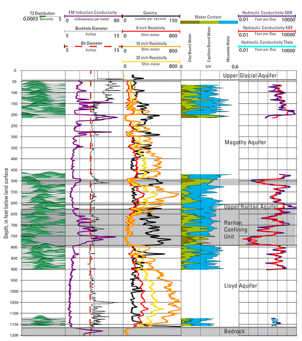
Borehole-geophysical logs are being collected from new and existing observation wells to provide information that cannot be obtained by drilling and sampling alone. The geophysical-logging systems being used in this study provide continuous-digital records that are dependent upon the physical properties of the sediment, the rock matrix, and the interstitial fluids. At each of the drilled boreholes, natural-gamma radiation (gamma), spontaneous potential (SP), single-point-resistance (SPR), and short-and long-normal resistivity (R) logs are being collected in mud-filled open boreholes before the casing is installed, then focused electromagnetic-induction (EM) logs are obtained after installation of the polyvinyl chloride (PVC) casing. Key existing observation wells are also being logged for EM to determine if saltwater intrusion has changed over time at that location. Nuclear Magnetic Resonance (NMR) logs are being collected at selected wells to determine variations in hydraulic conductivity of Long Island's hydrogeologic units.
Types of Geophysical Logs
The types of geophysical logs being used for this study, and their descriptions and uses are as follows:
- Natural-gamma radiation (gamma) logs — provide a record of the total gamma radiation detected in a borehole (Keys, 1990). Clays and fine-grained sediments tend to be more radioactive than the quartz sand that forms the bulk of the deposits on Long Island. Gamma logs commonly are used for lithologic and stratigraphic correlation.
- Spontaneous-potential (SP) logs — provide a record of the electrical potential, or voltage, which develops at the contact between clay beds and sand aquifers within a borehole (Keys, 1990). SP logs are used to determine lithology, bed thickness, and salinity of formation water (Keys, 1990).
- Single-point-resistance (SPR) logs —provide a measure of the resistance, in ohms, between an electrode in the borehole and an electrode at land surface. SPR logs are used to obtain high-resolution lithologic information.
- Normal-resistivity (R) logs—measure apparent resistivity in ohm-meters using two electrodes typically spaced 16 to 64 in. apart in the borehole, called short and long normal logs, respectively. R logs are used to interpret lithology and water salinity (Keys, 1990).
- Focused electromagnetic-induction (EM) logs —measure formation conductivity using an electromagnetic emitter coil that induces current loops within the surrounding formation to generate a secondary electromagnetic field. The intensity of the secondary field received by the receiver coil is proportional to the formation conductivity (Keys, 1990; Serra, 1984; Keys and MacCary, 1971). EM logs are used in conjunction with gamma logs to distinguish between conductive fluids and conductive clays, and have been used on Long Island to delineate the freshwater-saltwater interface (Chu and Stumm, 1995; Stumm, 1993, 1994, 2001; Stumm and Lange, 1996; Stumm and others, 2002, 2004).
- Nuclear Magnetic Resonance (NMR) logs — respond to the presence of hydrogen protons in the formation fluid to determine water content or fraction (equivalent to porosity in the saturated zone) and pore-size distribution. NMR logs can be used to estimate vertically continuous porosity and hydraulic conductivity in an adjacent formation (Walsh and others, 2013; Knight and others, 2016; Kendrick and others, 2021).
All borehole geophysical logs collected by the USGS are available online from the USGS Geolog Locator.

Core Analysis
Core samples obtained during drilling are being analyzed for minerology, grain size, and color (figure 4). The core samples are used to correlate borehole-geophysical logs and to determine contacts between hydrogeologic units. The thickness of each hydrogeologic unit is estimated at each observation well primarily from core data obtained during the drilling, from borehole-geophysical logs, driller’s logs, and through interpolation. Color descriptions of the core samples are based on the standard Munsell color chart (Natural Resources Conservation Service).

Surface Geophysics (H/V Passive Seismic)
H/V seismic is considered a "passive" seismic method because it does not require an explosive charge or hammer blow to induce seismic noise (figure 5). The H/V method measures three components of ambient seismic noise, which include micro tremors induced by wind, ocean waves, and anthropogenic (human) activity. The measured data are the vertical and two horizontal (north-south and east-west) components of the seismic noise.
The spectral ratio of the horizontal and vertical components of the measured ambient seismic noise is used to determine the fundamental seismic resonance at the site. Using this method depth to bedrock measurements are being collected throughout Long Island to fill in gaps between drilled boreholes.
Surface Geophysics (TDEM)
The time domain electromagnetic (TDEM) method is a surface-geophysical technique that uses a transmitter loop and receiver coil placed on the land surface, from which an electrical current is passed through the transmitter loop creating an electromagnetic field. This field is switched on and off, which induces eddy currents in the subsurface producing a secondary electromagnetic field. The decay of this secondary electromagnetic field is then measured by the receiver coil. The amplitude of the current starts to decay immediately, which induces more current to flow, but now at a greater depth from the transmitter loop. The deeper current flow also decays, which then induces even deeper currents to flow. Data are collected at the receiver coil, with progressively later times representing the electrical properties of the deeper layers in the subsurface. These data are then processed and inverted to produce a one dimensional resistivity curve.
Long Island is underlain by unconsolidated Holocene deposits, glacial deposits of Pleistocene age, and coastal-plain deposits of Late Cretaceous age. These sediments consist of gravel, sand, silt, and clay underlain by crystalline bedrock of early Paleozoic age (figure 2b). The bedrock is relatively impermeable, and forms the base of the groundwater-flow system on Long Island. The geologic and hydrologic units underlying Long Island have been studied and characterized by the USGS since the early 1900s. Much of this earlier work has been synthesized by Smolensky and others (1990); however, in this previous work, there continues to be uncertainty in areas of complex hydrogeology especially along the northern parts of Long Island where extensive glacial erosion and deposition has not been adequately mapped.
Approach
A synthesis of all existing lithologic data collected since the last framework compilation (Smolensky and others, 1990) is being augmented with a network of new observation wells that are being drilled in areas of complex hydrogeology to better define and reduce uncertainties in the hydrogeologic framework and to provide additional information for the numerical groundwater-flow model being developed as part of this study. Wells are being drilled to collect core samples, borehole-geophysical logs, water-quality samples, and groundwater levels. The drilling program consists of three phases with Phase 1 focused on western Long Island, Phase 2 on eastern Long Island, and Phase 3 on filling in gaps (Figure 1). Thus far Phase 1 and 2 wells have been drilled and installed. In addition, surface-geophysical methods are being utilized to fill in data gaps where no wells exist. These methods include passive-seismic and time-domain electromagnetic induction.
Drilling
The drilling program entails the use of mud-rotary drilling and split-spoon core sampling. Most boreholes are being drilled through the unconsolidated sediments into bedrock, with core samples collected at regular intervals for geologic analysis. Each drilled borehole is being cased with polyvinyl chloride (PVC) to allow for future groundwater sampling, groundwater-level measurements, and borehole-geophysical logging needed to assess long-term changes in aquifer conditions and saltwater-intrusion concerns.
Borehole Geophysics
Borehole-geophysical logs are being collected from new and existing observation wells to provide information that cannot be obtained by drilling and sampling alone. The geophysical-logging systems being used in this study provide continuous-digital records that are dependent upon the physical properties of the sediment, the rock matrix, and the interstitial fluids. At each of the drilled boreholes, natural-gamma radiation (gamma), spontaneous potential (SP), single-point-resistance (SPR), and short-and long-normal resistivity (R) logs are being collected in mud-filled open boreholes before the casing is installed, then focused electromagnetic-induction (EM) logs are obtained after installation of the polyvinyl chloride (PVC) casing. Key existing observation wells are also being logged for EM to determine if saltwater intrusion has changed over time at that location. Nuclear Magnetic Resonance (NMR) logs are being collected at selected wells to determine variations in hydraulic conductivity of Long Island's hydrogeologic units.
Types of Geophysical Logs
The types of geophysical logs being used for this study, and their descriptions and uses are as follows:
- Natural-gamma radiation (gamma) logs — provide a record of the total gamma radiation detected in a borehole (Keys, 1990). Clays and fine-grained sediments tend to be more radioactive than the quartz sand that forms the bulk of the deposits on Long Island. Gamma logs commonly are used for lithologic and stratigraphic correlation.
- Spontaneous-potential (SP) logs — provide a record of the electrical potential, or voltage, which develops at the contact between clay beds and sand aquifers within a borehole (Keys, 1990). SP logs are used to determine lithology, bed thickness, and salinity of formation water (Keys, 1990).
- Single-point-resistance (SPR) logs —provide a measure of the resistance, in ohms, between an electrode in the borehole and an electrode at land surface. SPR logs are used to obtain high-resolution lithologic information.
- Normal-resistivity (R) logs—measure apparent resistivity in ohm-meters using two electrodes typically spaced 16 to 64 in. apart in the borehole, called short and long normal logs, respectively. R logs are used to interpret lithology and water salinity (Keys, 1990).
- Focused electromagnetic-induction (EM) logs —measure formation conductivity using an electromagnetic emitter coil that induces current loops within the surrounding formation to generate a secondary electromagnetic field. The intensity of the secondary field received by the receiver coil is proportional to the formation conductivity (Keys, 1990; Serra, 1984; Keys and MacCary, 1971). EM logs are used in conjunction with gamma logs to distinguish between conductive fluids and conductive clays, and have been used on Long Island to delineate the freshwater-saltwater interface (Chu and Stumm, 1995; Stumm, 1993, 1994, 2001; Stumm and Lange, 1996; Stumm and others, 2002, 2004).
- Nuclear Magnetic Resonance (NMR) logs — respond to the presence of hydrogen protons in the formation fluid to determine water content or fraction (equivalent to porosity in the saturated zone) and pore-size distribution. NMR logs can be used to estimate vertically continuous porosity and hydraulic conductivity in an adjacent formation (Walsh and others, 2013; Knight and others, 2016; Kendrick and others, 2021).
All borehole geophysical logs collected by the USGS are available online from the USGS Geolog Locator.
Core Analysis
Core samples obtained during drilling are being analyzed for minerology, grain size, and color (figure 4). The core samples are used to correlate borehole-geophysical logs and to determine contacts between hydrogeologic units. The thickness of each hydrogeologic unit is estimated at each observation well primarily from core data obtained during the drilling, from borehole-geophysical logs, driller’s logs, and through interpolation. Color descriptions of the core samples are based on the standard Munsell color chart (Natural Resources Conservation Service).
Surface Geophysics (H/V Passive Seismic)
H/V seismic is considered a "passive" seismic method because it does not require an explosive charge or hammer blow to induce seismic noise (figure 5). The H/V method measures three components of ambient seismic noise, which include micro tremors induced by wind, ocean waves, and anthropogenic (human) activity. The measured data are the vertical and two horizontal (north-south and east-west) components of the seismic noise.
The spectral ratio of the horizontal and vertical components of the measured ambient seismic noise is used to determine the fundamental seismic resonance at the site. Using this method depth to bedrock measurements are being collected throughout Long Island to fill in gaps between drilled boreholes.
Surface Geophysics (TDEM)
The time domain electromagnetic (TDEM) method is a surface-geophysical technique that uses a transmitter loop and receiver coil placed on the land surface, from which an electrical current is passed through the transmitter loop creating an electromagnetic field. This field is switched on and off, which induces eddy currents in the subsurface producing a secondary electromagnetic field. The decay of this secondary electromagnetic field is then measured by the receiver coil. The amplitude of the current starts to decay immediately, which induces more current to flow, but now at a greater depth from the transmitter loop. The deeper current flow also decays, which then induces even deeper currents to flow. Data are collected at the receiver coil, with progressively later times representing the electrical properties of the deeper layers in the subsurface. These data are then processed and inverted to produce a one dimensional resistivity curve.