
George Tate (right, in light baseball cap) drives a raft on the Colorado River in Grand Canyon, 1992. The crane near the bow was used to deploy a small tripod holding a rotating sidescan sonar, which sat on the riverbed recording the motion of underwater sand dunes.
Images
Pacific Coastal and Marine Science Center images.
Filter Total Items: 1369

Sonar in the Grand Canyon, 1992
George Tate (right, in light baseball cap) drives a raft on the Colorado River in Grand Canyon, 1992. The crane near the bow was used to deploy a small tripod holding a rotating sidescan sonar, which sat on the riverbed recording the motion of underwater sand dunes.
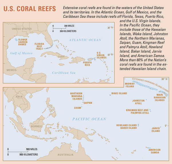
Map showing extent of U.S. coral reefs
Extensive coral reefs are found in the waters of the United States and its territories. In the Atlantic Ocean, Gulf of America, and the Caribbean Sea these include reefs off Florida, Texas, Puerto Rico, and the U.S. Virgin Islands.
Extensive coral reefs are found in the waters of the United States and its territories. In the Atlantic Ocean, Gulf of America, and the Caribbean Sea these include reefs off Florida, Texas, Puerto Rico, and the U.S. Virgin Islands.

Loma Prieta earthquake, Marina District
An automobile lies crushed under the third story of this apartment building in the Marina District. The ground levels are no longer visible because of structural failure and sinking due to liquefaction.
An automobile lies crushed under the third story of this apartment building in the Marina District. The ground levels are no longer visible because of structural failure and sinking due to liquefaction.

Giant Hawaiian Underwater Landslides
Large-scale poster describing USGS work.
The USGS, in cooperation with the UK Institute of Oceanographic Sciences (IOS) and others, took images of the seafloor 200 miles around the Hawaiian Islands using GLORIA. GLORIA is a long-range sonar that gives a bird’s-eye view of the seafloor.
Large-scale poster describing USGS work.
The USGS, in cooperation with the UK Institute of Oceanographic Sciences (IOS) and others, took images of the seafloor 200 miles around the Hawaiian Islands using GLORIA. GLORIA is a long-range sonar that gives a bird’s-eye view of the seafloor.

Sea Beam bathymetric map of the southern Escanaba Trough area
Sea Beam bathymetric map of the southern Escanaba Trough areaSea Beam bathymetric map of southern Escanaba Trough study area. Contour interval is 10m and is noted by color change. Locations of single- channel water-gun reflection profiles 4 to 12, cruise L1-86-NC, are shown.

Side of actively venting massive sulfide chimney colonized by tube worms and palm worms
Side of actively venting massive sulfide chimney colonized by tube worms and palm wormsPhoto shows the side of an actively venting massive sulfide chimney colonized by tube worms and palm worms.
Side of actively venting massive sulfide chimney colonized by tube worms and palm worms
Side of actively venting massive sulfide chimney colonized by tube worms and palm wormsPhoto shows the side of an actively venting massive sulfide chimney colonized by tube worms and palm worms.

Bathymetry map of Escanaba Trough
Sea Beam bathymetric map of Escanaba Trough from 1985. A, Northern half. B, Southern half. Contour interval is 50 m; each color change represents 100 m. Yellow indicates areas of no data.
Sea Beam bathymetric map of Escanaba Trough from 1985. A, Northern half. B, Southern half. Contour interval is 50 m; each color change represents 100 m. Yellow indicates areas of no data.

Tube worms and anemones colonize massive sulfide talus where diffuse hydrothermal venting is occurring
Tube worms and anemones colonize massive sulfide talus where diffuse hydrothermal venting is occurringPhoto shows tube worms and anemones colonizing massive sulfide talus where diffuse hydrothermal venting is occurring.

Older, oxidized sulfide deposit colonized by sponges at SESCA site
Older, oxidized sulfide deposit colonized by sponges at SESCA siteOlder, oxidized sulfide deposit colonized by sponges at SESCA site, southern half of Escanaba Trough.
Older, oxidized sulfide deposit colonized by sponges at SESCA site
Older, oxidized sulfide deposit colonized by sponges at SESCA siteOlder, oxidized sulfide deposit colonized by sponges at SESCA site, southern half of Escanaba Trough.

Sulfide mound and talus at NESCA site. Rectangular marker at center of photograph is 15 by 30 cm
Sulfide mound and talus at NESCA site. Rectangular marker at center of photograph is 15 by 30 cmSulfide mound and talus at NESCA site, northern half of Escanaba Trough. Rectangular marker at center of photograph is 15 by 30 cm.

Dynaphot photomicrographs of foraminifers from Escanaba Trough
Dynaphot photomicrographs of foraminifers from Escanaba TroughDynaphot photomicrographs of foraminifers from Escanaba Trough. A-D, Rhabdammina sp.
Dynaphot photomicrographs of foraminifers from Escanaba Trough
Dynaphot photomicrographs of foraminifers from Escanaba TroughDynaphot photomicrographs of foraminifers from Escanaba Trough. A-D, Rhabdammina sp.

Side of sulfide mound showing cluster of tube worms, anemones, and bacterial mats
Side of sulfide mound showing cluster of tube worms, anemones, and bacterial matsPhoto shows side of sulfide mound showing cluster of tube worms, anemones, and bacterial mats.
Side of sulfide mound showing cluster of tube worms, anemones, and bacterial mats
Side of sulfide mound showing cluster of tube worms, anemones, and bacterial matsPhoto shows side of sulfide mound showing cluster of tube worms, anemones, and bacterial mats.

Hydrothermal deposits (primarily barite) adjacent to site of active venting
Hydrothermal deposits (primarily barite) adjacent to site of active ventingHydrothermal deposits (primarily barite) adjacent to site of active venting. Shiny black material is possibly pyrobitumen.
Hydrothermal deposits (primarily barite) adjacent to site of active venting
Hydrothermal deposits (primarily barite) adjacent to site of active ventingHydrothermal deposits (primarily barite) adjacent to site of active venting. Shiny black material is possibly pyrobitumen.

Glassy, fresh pillow basalt flow at NESCA site
Glassy, fresh pillow basalt flow at the NESCA site, northern half of Escanaba Trough.
Glassy, fresh pillow basalt flow at the NESCA site, northern half of Escanaba Trough.

Cape Flattery topographic map, 1985
Topographic map of the Cape Flattery region (U.S. Geological Survey Cape Flattery Quadrangle, 15-min series).
Topographic map of the Cape Flattery region (U.S. Geological Survey Cape Flattery Quadrangle, 15-min series).

Readying the grappling hook
George Tate playfully brandishes a grappling hook in a boat in Cook Inlet, Alaska, 1978. The driver (not shown) and George are about to motor away from the research vessel Sea Sounder to drag for the large tripod dubbed the Geoprobe. The apparatus had not deployed its recovery float and line, so the scientists had to try to hook it up off the seafloor.
George Tate playfully brandishes a grappling hook in a boat in Cook Inlet, Alaska, 1978. The driver (not shown) and George are about to motor away from the research vessel Sea Sounder to drag for the large tripod dubbed the Geoprobe. The apparatus had not deployed its recovery float and line, so the scientists had to try to hook it up off the seafloor.

Three geologists and a plane
Three pioneers of USGS geological studies, in 1965, from left to right: Parke D. Snavely, Jr., Robert E. Wallace, and Thomas W. Dibblee, in front of a 1964 Cessna 182G Skylane.
Three pioneers of USGS geological studies, in 1965, from left to right: Parke D. Snavely, Jr., Robert E. Wallace, and Thomas W. Dibblee, in front of a 1964 Cessna 182G Skylane.

Chenega Village after tsunami waves hit in 1964
Photograph taken in 1964 of the main part of the Chenega village site in Alaska. Pilings in the ground mark the former locations of homes swept away by tsunami waves. The schoolhouse on high ground was undamaged.
Photograph taken in 1964 of the main part of the Chenega village site in Alaska. Pilings in the ground mark the former locations of homes swept away by tsunami waves. The schoolhouse on high ground was undamaged.

Aftermath of Chilean tsunami in Hilo, Hawaii
Aftermath of the 1960 Chilean tsunami in Hilo, Hawaii, where the tsunami caused 61 deaths.
Aftermath of the 1960 Chilean tsunami in Hilo, Hawaii, where the tsunami caused 61 deaths.

Front of the William Wrigley, Jr. Company building in west Santa Cruz
Front of the William Wrigley, Jr. Company building in west Santa CruzFront of the Wm. Wrigley Jr. Co. building in 1955, now home to the USGS Pacific Coastal and Marine Science Center.
Front of the William Wrigley, Jr. Company building in west Santa Cruz
Front of the William Wrigley, Jr. Company building in west Santa CruzFront of the Wm. Wrigley Jr. Co. building in 1955, now home to the USGS Pacific Coastal and Marine Science Center.

USCG Cutter Escanaba
In 1932, the U.S. Coast Guard commissioned the construction of a 165-foot, 1,500-horsepower ship in Bay City, Michigan. This was the U.S. Coast Guard Cutter (USCGC) Escanaba.
In 1932, the U.S. Coast Guard commissioned the construction of a 165-foot, 1,500-horsepower ship in Bay City, Michigan. This was the U.S. Coast Guard Cutter (USCGC) Escanaba.