
Preliminary Analysis of the 2009 Samoa Tsunami
The tsunami that was triggered by a magnitude 8.1 earthquake on September 29, 2009, caused significant damage and loss of life on Samoa, American Samoa, and Tonga. In the hopes that disasters such as this can be minimized in the future, we attempt to understand the mechanism and impact of this tsunami. The information presented here is focused on geologic aspects of the disaster.
More information on the September 29, 2009 M=8.1 Samoa Islands earthquake is available from the USGS National Earthquake Information Center.
More information on the September 29, 2009 tsunami is available from the NOAA Center for Tsunami Research event page.
Tectonic and Seismological Background

The September 2009 Samoa tsunami was generated by an unusual type of earthquake that occurs near ocean trenches. Unlike typical tsunamigenic earthquakes that occur on the thrust fault that separates tectonic plates in a subduction zone (termed the inter-plate thrust), outer-rise earthquakes, as they are called, occur within the subducting or downgoing plate before it enters the subduction zone. There have only been a few verified instances of tsunamis generated by outer-rise earthquakes, but those that have occurred have been devastating. The 1933 Sanriku tsunami generated from a magnitude 8.4 outer-rise earthquake resulted in over 3,000 deaths in Japan and significant damage on the Island of Hawai'i. The 1977 Sumba magnitude 8.2-8.3 outer-rise earthquake resulted in 189 deaths in Indonesia. The 2009 Samoa outer-rise earthquake may have resulted in comparable fatalities and was the fourth largest outer-rise earthquake that has been instrumentally recorded since 1900.
Outer-rise earthquakes are caused by stresses in the subducting, oceanic plate induced by bending as the plate enters the trench.

Flexure of the plate elevates the sea floor, creating an oceanic feature known as an "outer rise" that parallels the oceanic trench. As the plate flexes, tensional stress in the oceanic crust creates potentially large normal faults. Crustal stresses caused by earthquakes on the inter-plate thrust fault in subduction zones can also be transferred to the outer rise, triggering earthquakes on normal faults that are already close to failure.
At the Tonga trench, the Pacific plate entering the subduction zone is particularly old and dense, resulting in a steep angle of descent and many normal faults near the trench. The 2009 Samoa earthquake occurred east of the Tonga trench, near the northern terminus of the Tonga volcanic arc where the trench takes a sharp bend to the west.
A series of prominent normal faults are observed as the trench curves around the northern Tonga arc.
Preliminary analysis of how much the fault slipped during the September 29, 2009, earthquake is given by the finite-fault model on the NEIC event page. This analysis of seismic waveform data indicates that there was a large amount of slip near the sea floor, further suggesting that the earthquake may have produced a mappable step on the sea floor where the causative fault intersects the surface.
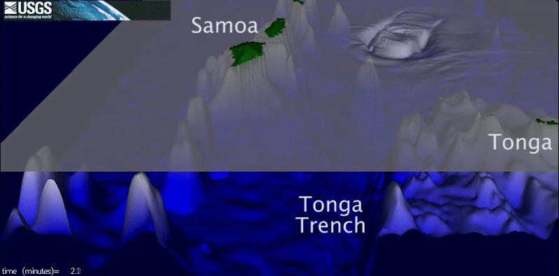
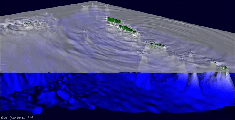
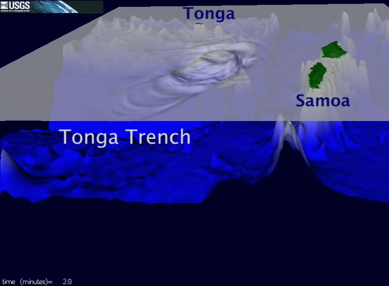
Preliminary Simulation of Tsunami
Many of the aforementioned characteristics of outer-rise earthquakes can explain why the tsunami was so large. The maximum fault slip for this earthquake is much higher than for an inter-plate thrust earthquake of comparable magnitude. This translates to higher vertical movement of the sea floor, lifting the entire ocean above the rupture zone. Moreover, tsunami generation occurred in much deeper water than normal. When a tsunami travels from deep water to shallow water, the speed of the wave crest or trough slows, the wavelength decreases, and the amplitude increases. This process is sometimes referred to as “shoaling amplification”. (See Life of a Tsunami.) If a tsunami starts off in deeper water, then it will be amplified to a greater extent by the time it reaches shore than a comparable tsunami that starts off in shallow water. Preliminary field survey data of American Samoa indicates that the tsunami runups (height above ambient sea level) reached as much as 12 m, which is larger than most tsunamis generated by magnitude 8.0 earthquakes on the inter-plate thrust.
The animations below show the preliminary tsunami simulation as viewed from different directions.
It is hoped that continued research on the nature and occurrence of outer-rise earthquakes around the world will help identify potential sites for future outer-rise earthquakes of this size and help mitigate the tsunami hazard associated with such rare but devastating events.

Tsunami Hazards, Modeling, and the Sedimentary Record

Tsunami and Earthquake Research

Preliminary Simulations of Recent Tsunamis

USGS Scientists in Samoa and American Samoa Studying Impacts of Tsunami in 2009
The tsunami that was triggered by a magnitude 8.1 earthquake on September 29, 2009, caused significant damage and loss of life on Samoa, American Samoa, and Tonga. In the hopes that disasters such as this can be minimized in the future, we attempt to understand the mechanism and impact of this tsunami. The information presented here is focused on geologic aspects of the disaster.
More information on the September 29, 2009 M=8.1 Samoa Islands earthquake is available from the USGS National Earthquake Information Center.
More information on the September 29, 2009 tsunami is available from the NOAA Center for Tsunami Research event page.
Tectonic and Seismological Background
The September 2009 Samoa tsunami was generated by an unusual type of earthquake that occurs near ocean trenches. Unlike typical tsunamigenic earthquakes that occur on the thrust fault that separates tectonic plates in a subduction zone (termed the inter-plate thrust), outer-rise earthquakes, as they are called, occur within the subducting or downgoing plate before it enters the subduction zone. There have only been a few verified instances of tsunamis generated by outer-rise earthquakes, but those that have occurred have been devastating. The 1933 Sanriku tsunami generated from a magnitude 8.4 outer-rise earthquake resulted in over 3,000 deaths in Japan and significant damage on the Island of Hawai'i. The 1977 Sumba magnitude 8.2-8.3 outer-rise earthquake resulted in 189 deaths in Indonesia. The 2009 Samoa outer-rise earthquake may have resulted in comparable fatalities and was the fourth largest outer-rise earthquake that has been instrumentally recorded since 1900.
Outer-rise earthquakes are caused by stresses in the subducting, oceanic plate induced by bending as the plate enters the trench.
Flexure of the plate elevates the sea floor, creating an oceanic feature known as an "outer rise" that parallels the oceanic trench. As the plate flexes, tensional stress in the oceanic crust creates potentially large normal faults. Crustal stresses caused by earthquakes on the inter-plate thrust fault in subduction zones can also be transferred to the outer rise, triggering earthquakes on normal faults that are already close to failure.
At the Tonga trench, the Pacific plate entering the subduction zone is particularly old and dense, resulting in a steep angle of descent and many normal faults near the trench. The 2009 Samoa earthquake occurred east of the Tonga trench, near the northern terminus of the Tonga volcanic arc where the trench takes a sharp bend to the west.
A series of prominent normal faults are observed as the trench curves around the northern Tonga arc.
Preliminary analysis of how much the fault slipped during the September 29, 2009, earthquake is given by the finite-fault model on the NEIC event page. This analysis of seismic waveform data indicates that there was a large amount of slip near the sea floor, further suggesting that the earthquake may have produced a mappable step on the sea floor where the causative fault intersects the surface.
Preliminary Simulation of Tsunami
Many of the aforementioned characteristics of outer-rise earthquakes can explain why the tsunami was so large. The maximum fault slip for this earthquake is much higher than for an inter-plate thrust earthquake of comparable magnitude. This translates to higher vertical movement of the sea floor, lifting the entire ocean above the rupture zone. Moreover, tsunami generation occurred in much deeper water than normal. When a tsunami travels from deep water to shallow water, the speed of the wave crest or trough slows, the wavelength decreases, and the amplitude increases. This process is sometimes referred to as “shoaling amplification”. (See Life of a Tsunami.) If a tsunami starts off in deeper water, then it will be amplified to a greater extent by the time it reaches shore than a comparable tsunami that starts off in shallow water. Preliminary field survey data of American Samoa indicates that the tsunami runups (height above ambient sea level) reached as much as 12 m, which is larger than most tsunamis generated by magnitude 8.0 earthquakes on the inter-plate thrust.
The animations below show the preliminary tsunami simulation as viewed from different directions.
It is hoped that continued research on the nature and occurrence of outer-rise earthquakes around the world will help identify potential sites for future outer-rise earthquakes of this size and help mitigate the tsunami hazard associated with such rare but devastating events.
Tsunami Hazards, Modeling, and the Sedimentary Record
Tsunami and Earthquake Research
Preliminary Simulations of Recent Tsunamis