
Santa Cruz Core Laboratories
USGS scientists collect core samples from estuaries, lakes, coasts, and marine environments to study a range of physical and chemical properties preserved in sediments over time. They process and analyze these core samples in the Pacific Coastal and Marine Science Center’s Core Labs.
This is among the top core labs in the country. It’s a one-stop-shop for researchers who use sediment and coral cores to investigate past environmental events and conditions. By collecting information about the past found within core samples, geologists contribute towards a better understanding of how conditions may change in the future.
The Core Labs at the Pacific Coastal and Marine Science Center comprise:
Media
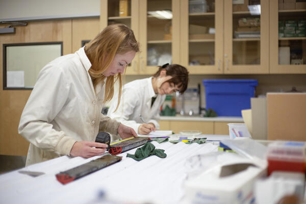
Sub-sampling a sediment core.
Sources/Usage: Public Domain. View Media Details
Media
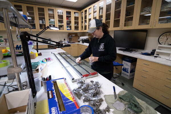
Sub-sampling a sediment core.
Sources/Usage: Public Domain. View Media Details
Media
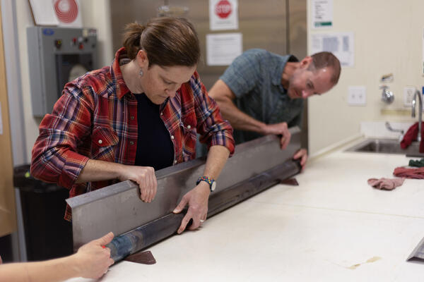
Splitting a sediment core.
Sources/Usage: Public Domain. View Media Details
News
Ozette Lake: A natural seismograph along the northern Cascadia Subduction Zone (Video)
Ozette Lake: A natural seismograph along the northern Cascadia Subduction Zone (Video)
New Video Offers Virtual Tour of the USGS Sediment Core Lab
New Video Offers Virtual Tour of the USGS Sediment Core Lab
Searching for Evidence of Past Tsunamis in Sediment Cores
Searching for Evidence of Past Tsunamis in Sediment Cores
Publications
Marine paleoseismic evidence for seismic and aseismic slip along the Hayward-Rodgers Creek fault system in northern San Pablo Bay Marine paleoseismic evidence for seismic and aseismic slip along the Hayward-Rodgers Creek fault system in northern San Pablo Bay
Distinguishing between seismic and aseismic fault slip in the geologic record is difficult, yet fundamental to estimating the seismic potential of faults and the likelihood of multi-fault ruptures. We integrated chirp sub-bottom imaging with targeted cross-fault coring and core analyses of sedimentary proxy data to characterize vertical deformation and slip behavior within an extensional...
Late Holocene environmental change in Celestun Lagoon, Yucatan, Mexico Late Holocene environmental change in Celestun Lagoon, Yucatan, Mexico
Epikarst estuary response to hydroclimate change remains poorly understood, despite the well-studied link between climate and karst groundwater aquifers. The influence of sea-level rise and coastal geomorphic change on these estuaries obscures climate signals, thus requiring careful development of paleoenvironmental histories to interpret the paleoclimate archives. We used foraminifera...
California deepwater investigations and groundtruthing (Cal DIG) I: Fault and shallow geohazard analysis offshore Morro Bay California deepwater investigations and groundtruthing (Cal DIG) I: Fault and shallow geohazard analysis offshore Morro Bay
The California Deepwater Investigations and Groundtruthing (Cal DIG) I project focuses on the potential seafloor hazards and impacts of alternative energy infrastructure in the outer continental shelf region offshore of south-central California. This is one of three reports covering a single study area located between Monterey and Point Conception, California in federal waters outside of...
Science

Cascadia Subduction Zone Marine Geohazards
Societal Issue: Uncertainty related to rupture extent, slip distribution, and recurrence of past subduction megathrust earthquakes in the Pacific Northwest (northern CA, OR, WA, and southern BC) leads to ambiguity in earthquake and tsunami hazard assessments and hinders our ability to prepare for future events.
By
Natural Hazards Mission Area, Coastal and Marine Hazards and Resources Program, Pacific Coastal and Marine Science Center, Santa Cruz Core Scanning Laboratory, Santa Cruz Core Laboratories, Santa Cruz Core Splitting Laboratory, Deep Sea Exploration, Mapping and Characterization, Subduction Zone Science

Hazards: EXPRESS
Marine geohazards including earthquakes, landslides, and tsunamis lie offshore of densely populated areas of California, Oregon, and Washington. One goal of EXPRESS is to improve assessments of these hazards.

Coastal and Marine Geohazards of the U.S. West Coast and Alaska
Coastal and marine geohazards are sudden and extreme events beneath the ocean that threaten coastal populations. These underwater hazards include earthquakes, volcanic eruptions, landslides, and tsunamis. The tectonically active west coast of the Americas is prone to such hazards, as it lies along the boundaries of major tectonic plates that make up the Earth's crust—the North American, Caribbean...