Dry conditions at cattle water sources in western Colorado
Dry conditions at cattle water sources in western ColoradoDry conditions at cattle water sources in western Colorado.

Official websites use .gov
A .gov website belongs to an official government organization in the United States.
Secure .gov websites use HTTPS
A lock () or https:// means you’ve safely connected to the .gov website. Share sensitive information only on official, secure websites.
Below are images associated with SBSC's science and staff. Images appear according to the year they were taken. To search, type a keyword or select a year from the dropdown menu. Or, click through the pages using the arrows at the bottom of the page.

Dry conditions at cattle water sources in western Colorado.
Dry conditions at cattle water sources in western Colorado.

Cattle walking across biological soil crusts in southeastern Utah.
Cattle walking across biological soil crusts in southeastern Utah.
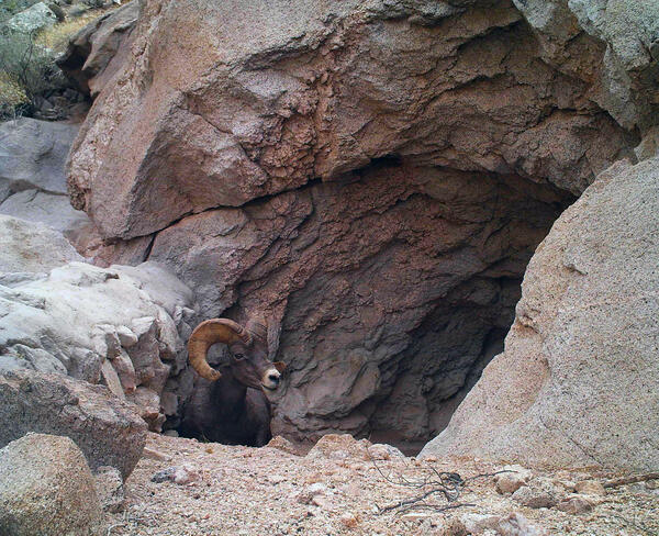
A bighorn sheep emerges from the Buck Tank water catchment, called a tinaja, at Cabeza Prieta National Wildlife Refuge (CPNWR), southern AZ. Photo courtesy of the US Fish and Wildlife Service, CPNWR.
A bighorn sheep emerges from the Buck Tank water catchment, called a tinaja, at Cabeza Prieta National Wildlife Refuge (CPNWR), southern AZ. Photo courtesy of the US Fish and Wildlife Service, CPNWR.
Photograph of sandbar about 45 miles downstream from Lees Ferry, Arizona showing river party camping on large sandbar deposited by the 2008 high-flow experiment (left) and again in August 2011 (right) when the size of the sandbar and campsite was much smaller. USGS photos, public domain.
Photograph of sandbar about 45 miles downstream from Lees Ferry, Arizona showing river party camping on large sandbar deposited by the 2008 high-flow experiment (left) and again in August 2011 (right) when the size of the sandbar and campsite was much smaller. USGS photos, public domain.
Technicians setting up to install remote PIT tags at the Little Colorado River. USGS photo.
Technicians setting up to install remote PIT tags at the Little Colorado River. USGS photo.
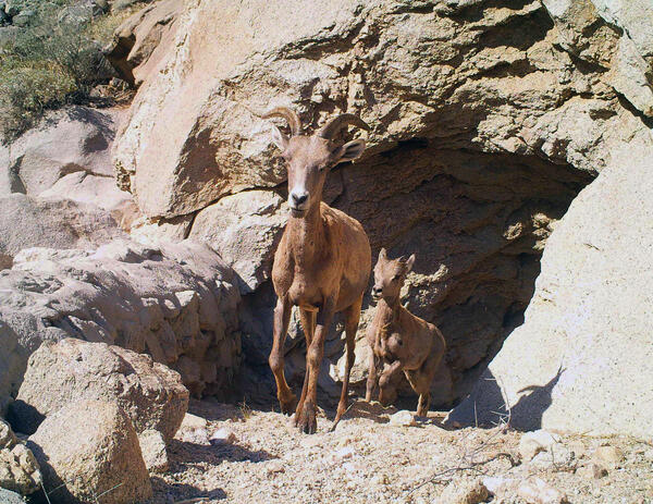
Two bighorn sheep emerge from Buck Tank water catchment, called a tinaja, in Cabeza Prieta National Wildlife Refuge (CPNWR), southern Arizona. Photo courtesy of the US Fish and Wildlife Service, CPNWR.
Two bighorn sheep emerge from Buck Tank water catchment, called a tinaja, in Cabeza Prieta National Wildlife Refuge (CPNWR), southern Arizona. Photo courtesy of the US Fish and Wildlife Service, CPNWR.

A USGS repeat photograph of Glen Canyon Dam taken on April 20, 2011 as a match to the 1889 Franklin Nims image of the site before the dam was built, at Colorado River mile -14.7, during the Stanton Expedition. This view was also matched in 1992 by the USGS. The view is taken upstream from river left.
A USGS repeat photograph of Glen Canyon Dam taken on April 20, 2011 as a match to the 1889 Franklin Nims image of the site before the dam was built, at Colorado River mile -14.7, during the Stanton Expedition. This view was also matched in 1992 by the USGS. The view is taken upstream from river left.

A USGS repeat photograph of Glen Canyon Dam taken on April 20, 2011, as a match to the 1889 Franklin Nims image of the site before the dam was built, at Colorado River mile -14.7, during the Stanton Expedition. This view was also matched in 1992 by the USGS. The view is taken looking downstream below the dam, from river left.
A USGS repeat photograph of Glen Canyon Dam taken on April 20, 2011, as a match to the 1889 Franklin Nims image of the site before the dam was built, at Colorado River mile -14.7, during the Stanton Expedition. This view was also matched in 1992 by the USGS. The view is taken looking downstream below the dam, from river left.

Steep, rocky slopes in Saguaro National Park near Tucson, AZ provide habitat for saguaros and may buffer populations from the negative effects of drought. Photo courtesy of Daniel Winkler, USGS SBSC.
Steep, rocky slopes in Saguaro National Park near Tucson, AZ provide habitat for saguaros and may buffer populations from the negative effects of drought. Photo courtesy of Daniel Winkler, USGS SBSC.

Repeat photograph of Saguaro National Monument (now Saguaro National Park) East, Rincon Mountain District. This photo was taken in 2010 by Dr. Ray Turner, USGS and is a match of a 1935 photograph taken by the National Park Service (NPS).
Repeat photograph of Saguaro National Monument (now Saguaro National Park) East, Rincon Mountain District. This photo was taken in 2010 by Dr. Ray Turner, USGS and is a match of a 1935 photograph taken by the National Park Service (NPS).

USFWS and USGS partner on brown trout research in Grand Canyon's Colorado River. This trout was removed from Bright Angel Creek, a tributary of the Colorado River. Photo courtesy of Brian Healy, formerly with National Park Service, Grand Canyon National Park, and now with USGS.
USFWS and USGS partner on brown trout research in Grand Canyon's Colorado River. This trout was removed from Bright Angel Creek, a tributary of the Colorado River. Photo courtesy of Brian Healy, formerly with National Park Service, Grand Canyon National Park, and now with USGS.

A landscape view of the Colorado River, Phantom Ranch, Bright Angel Bridge, and Bright Angel Creek in Grand Canyon National Park. Photo courtesy of Brian Healy, formerly with National Park Service, Grand Canyon National Park, and now with USGS.
A landscape view of the Colorado River, Phantom Ranch, Bright Angel Bridge, and Bright Angel Creek in Grand Canyon National Park. Photo courtesy of Brian Healy, formerly with National Park Service, Grand Canyon National Park, and now with USGS.

Electrofishing in a tributary in Grand Canyon to remove non-native fish. Photo courtesy of Brian Healy, formerly with National Park Service, Grand Canyon National Park, and now with USGS.
Electrofishing in a tributary in Grand Canyon to remove non-native fish. Photo courtesy of Brian Healy, formerly with National Park Service, Grand Canyon National Park, and now with USGS.

A captured brown trout has partially eaten several smaller fish and has tails protruding from its mouth. Photo courtesy of Brian Healy, formerly with National Park Service, Grand Canyon National Park, and now with USGS.
A captured brown trout has partially eaten several smaller fish and has tails protruding from its mouth. Photo courtesy of Brian Healy, formerly with National Park Service, Grand Canyon National Park, and now with USGS.
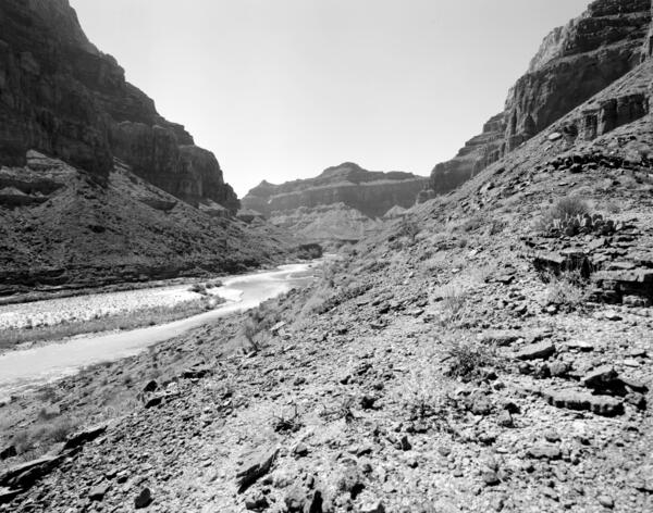
September 19, 2010: Colorado River, Grand Canyon, River Mile 65.5, Palisades Creek, across canyon view from river left. The rapid has not changed in the intervening two decades, and many of the same mesquite thickets are still present on the debris fan in the foreground.
September 19, 2010: Colorado River, Grand Canyon, River Mile 65.5, Palisades Creek, across canyon view from river left. The rapid has not changed in the intervening two decades, and many of the same mesquite thickets are still present on the debris fan in the foreground.
September 19, 2010: Colorado River, Grand Canyon, River Mile 65.5, Palisades Creek, across canyon view from river left. The rapid has not changed in the intervening two decades, and many of the same mesquite thickets are still present on the debris fan in the foreground.
September 19, 2010: Colorado River, Grand Canyon, River Mile 65.5, Palisades Creek, across canyon view from river left. The rapid has not changed in the intervening two decades, and many of the same mesquite thickets are still present on the debris fan in the foreground.
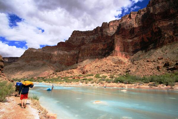
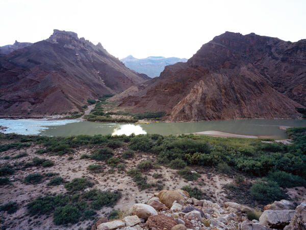
September 19, 2010: Colorado River, Grand Canyon, River Mile 61.4, Little Colorado River, Across Canyon View from River Right. The gravel bars have changed little in their overall location, lower water levels have allowed riparian vegetation to become established on them. The riparian vegetation, mostly tamarisk and arrowweed, has increased in height and density.
September 19, 2010: Colorado River, Grand Canyon, River Mile 61.4, Little Colorado River, Across Canyon View from River Right. The gravel bars have changed little in their overall location, lower water levels have allowed riparian vegetation to become established on them. The riparian vegetation, mostly tamarisk and arrowweed, has increased in height and density.
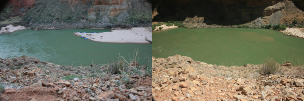
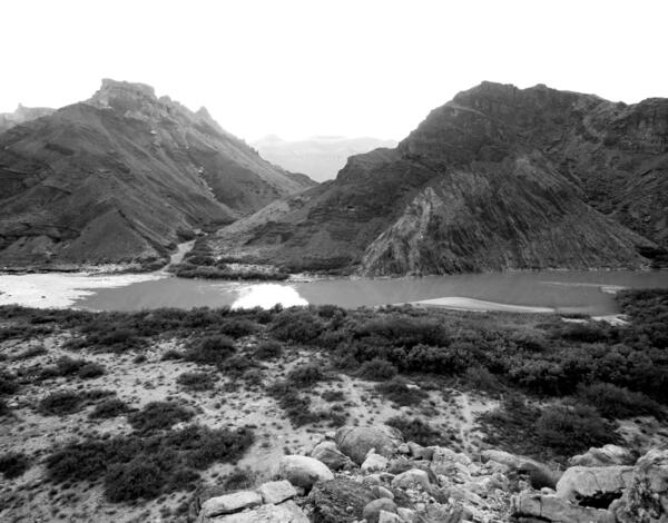
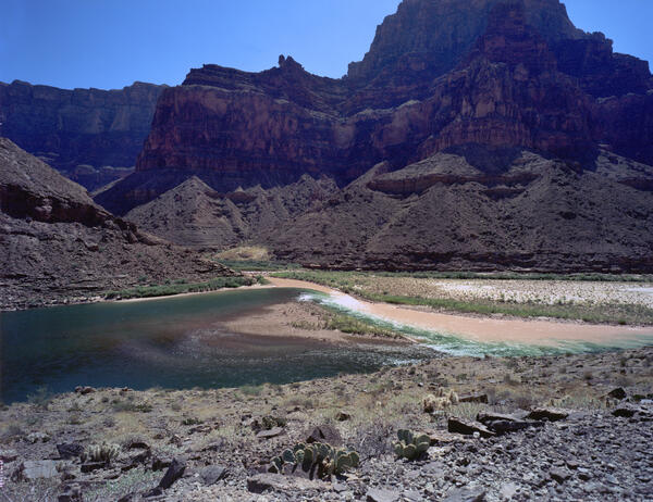
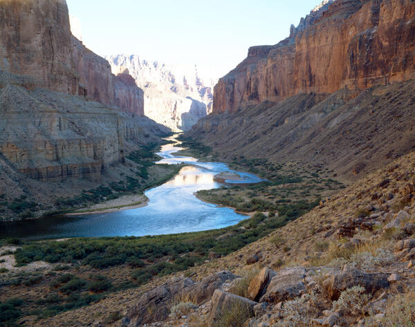
September 19, 2010: Colorado River, Grand Canyon, River Mile 61.4, Little Colorado River, Downstream View from River Right. The muddy water of the Little Colorado River can be seen intermixing with the flow of the mainstem Colorado River, which generally runs clear in Marble Canyon due to the sediment-settling that occurs upstream in Lake Powell.
September 19, 2010: Colorado River, Grand Canyon, River Mile 61.4, Little Colorado River, Downstream View from River Right. The muddy water of the Little Colorado River can be seen intermixing with the flow of the mainstem Colorado River, which generally runs clear in Marble Canyon due to the sediment-settling that occurs upstream in Lake Powell.

September 19, 2010: Colorado River, Grand Canyon, River Mile 61.4, Little Colorado River, Downstream View from River Right. The muddy water of the Little Colorado River can be seen intermixing with the flow of the mainstem Colorado River, which generally runs clear in Marble Canyon due to the sediment-settling that occurs upstream in Lake Powell.
September 19, 2010: Colorado River, Grand Canyon, River Mile 61.4, Little Colorado River, Downstream View from River Right. The muddy water of the Little Colorado River can be seen intermixing with the flow of the mainstem Colorado River, which generally runs clear in Marble Canyon due to the sediment-settling that occurs upstream in Lake Powell.
September 18, 2010: Colorado River, Grand Canyon, River Mile 52.8, Nankoweap Creek, Downstream View from River Right. Sandbars continue to decrease in exposed area owing to erosion and establishment of vegetation, both native mesquite and non-native tamarisk.
September 18, 2010: Colorado River, Grand Canyon, River Mile 52.8, Nankoweap Creek, Downstream View from River Right. Sandbars continue to decrease in exposed area owing to erosion and establishment of vegetation, both native mesquite and non-native tamarisk.

September 18, 2010. Colorado River, Grand Canyon, River Mile 52.8, Nankoweap, Downstream View from River Right. Riparian vegetation continues to increase along the river, reducing the amount of sand that is visible at this distance. There has been a slight increase in the amount of mesquite, but overall it appears to be similar to that present 19 years before.
September 18, 2010. Colorado River, Grand Canyon, River Mile 52.8, Nankoweap, Downstream View from River Right. Riparian vegetation continues to increase along the river, reducing the amount of sand that is visible at this distance. There has been a slight increase in the amount of mesquite, but overall it appears to be similar to that present 19 years before.