
Erosion
Erosion
Filter Total Items: 18

New Tools for Modern Land Management Decisions
In an era of rapid land use changes, it is imperative that land managers and policymakers have actionable and current information available for decision processes. In this work, we seek to meet these needs through new data products and decision support tools built on digital soil mapping, new vegetation cover maps, agency inventory and monitoring data sets, and cutting-edge analytical frameworks...

Biological Soil Crust ("Biocrust") Science
Biological soil crusts (biocrusts) are commonly found on the soil surface in arid and semi-arid ecosystems (collectively called drylands). Biocrusts can consist of mosses, cyanobacteria, lichens, algae, and microfungi, and they strongly interact with the soil. These organisms or consortium of disparate organisms, depending on the specific biocrust, are important to the functioning of ecosystems...
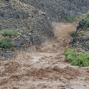
A New App to Report Flash Floods and Debris Flows in Grand Canyon
A new community science tool helps scientists gather valuable information on hazardous events such as floods, debris flows, and landslides that occur in the backcountry of Grand Canyon National Park. Visitors to Grand Canyon can help improve our understanding of the impacts these events have which helps to improve future warnings.

SBSC: Providing Unbiased Actionable Science & Information to Support Natural Resource Management Needs of the U.S. & Department of the Interior Priorities
The U.S. Geological Survey Southwest Biological Science Center (SBSC) is uniquely positioned in the Colorado River Basin to provide sound information, specialized expertise, and innovative tools to support the management and sustained use of natural resources on public and Tribal lands in the Southwest U.S.

RAMPS: Restoration Assessment & Monitoring Program for the Southwest
The Restoration Assessment and Monitoring Program for the Southwest (RAMPS) seeks to assist U.S. Department of the Interior (DOI) and other land management agencies in developing successful techniques for improving land condition in dryland ecosystems of the southwestern United States. Invasion by non-native species, wildfire, drought, and other disturbances are growing rapidly in extent and...

River Geomorphology, Sediment Storage, Sandbar and Campsite Monitoring in Grand Canyon
River channels and their adjacent floodplains are ever evolving in form and composition in response to changing patterns of streamflow, the quantity and size of supplied sediment, and feedbacks with the riparian and aquatic ecosystems. Changes in channel form affect aquatic and riparian habitats, which are important for plants, animals, and insects. Erosion and deposition of river channels and...

SBSC Tribal Partnerships
The Southwest Biological Science Center (SBSC) conducts and provides scientific information as part of our mission and Federal Trust Responsibility to strengthen relationships and build partnerships with sovereign tribal nations. Here, we highlight a few examples of projects with tribal partners.

Genetics for Western Restoration and Conservation (GWRC)
Research using genetic principles, methods, and data provides critical information for restoration and conservation science. Genetic research may rely only upon genomic sequencing techniques, which generate abundant, genome-wide DNA sequences that can provide a glimpse into a species’ evolutionary history and adaptations. Genetic research may also look at an organism’s physical traits to...

High-Flow Experiments on the Colorado River
Glen Canyon Dam has altered flow and sediment dynamics of the Colorado River in Grand Canyon. Before the dam was completed in 1963, the Colorado River carried a large amount of sand, silt, and clay through Grand Canyon, some of which was deposited during spring floods to create large and abundant sandbars. Sandbars in Grand Canyon are valued as camping areas, create aquatic and riparian habitat...

Drought Adaptation Strategies for Arid Grasslands
Helping National Parks in the 4-Corners region manage grasslands in a changing world.

Drought & Grazing Experiment: Understanding Impacts and Identifying Mitigation Strategies
Drylands (sometimes called ‘deserts’ or ‘arid and semi-arid' ecosystems) are defined by water scarcity. Understanding how land-use activities may effect dryland ecosystems and dryland ecological processes is a high priority for land conservation and management. Grazing by domestic livestock (typically cattle but also sheep and goats) is the most widespread land-use in drylands globally and a large...

Extended Drought in Drylands
Drylands are moisture-limited environments that cover ~40% of the global land surface. Ecosystems in drylands include the grasslands, shrublands, woodlands, riparian areas, and rivers that comprise most of the western United States and most of the land managed by the DOI, other federal agencies, and tribal Nations.