
Dauphin Island, Alabama. Three-dimensional views of island topography (A-C), post-Katrina oblique aerial photograph (D), and differences in topography from Hurricanes Ivan (E) and Katrina (F). The view is along the island, looking from east to west, with the Gulf of Mexico to the left and Mississippi Sound to the right.
Images
St. Petersburg Coastal and Marine Science Center images.
Filter Total Items: 745

Dauphin Island, Alabama
Dauphin Island, Alabama. Three-dimensional views of island topography (A-C), post-Katrina oblique aerial photograph (D), and differences in topography from Hurricanes Ivan (E) and Katrina (F). The view is along the island, looking from east to west, with the Gulf of Mexico to the left and Mississippi Sound to the right.

Photo sets of Waveland, Mississippi, pre- and post-Katrina
Photo sets of Waveland, Mississippi, pre- and post-KatrinaThe top image was taken off the coast of Bay St. Louis, Mississippi, in July 1998 by researchers at the University of New Orleans. In this image, notice the large multi-story houses, some of which are built on stilts to protect the homes from flooding. The bottom image shows the same location on August 31, 2005, two days after landfall of Hurricane Katrina.

Before and after photos showing destroyed pier house and classic home
Before and after photos showing destroyed pier house and classic homeIn the top image, taken in 1998, notice the pier, pier house, and the antebellum house. The bottom image shows the same location on August 31, 2005, two days after Hurricane Katrina made landfall. This photo shows the complete destruction of these landmarks.

Photo sets of Waveland, Mississippi, pre- and post-Katrina
Photo sets of Waveland, Mississippi, pre- and post-KatrinaThe top image, taken off the coast of Waveland, Mississippi, in July 1998, shows several large oceanfront homes, and thick wooded vegetation bordering the sandy beach. The bottom image shows the same location on August 31, 2005, two days after landfall of Hurricane Katrina.

Leptogorgia chilensis, Stylaster californicus, and a painted greenling
Leptogorgia chilensis, Stylaster californicus, and a painted greenlingLeptogorgia chilensis, Stylaster californicus, and a painted greenling (Oxylebius pictus) at 42 meters depth on Farnsworth Bank.
Leptogorgia chilensis, Stylaster californicus, and a painted greenling
Leptogorgia chilensis, Stylaster californicus, and a painted greenlingLeptogorgia chilensis, Stylaster californicus, and a painted greenling (Oxylebius pictus) at 42 meters depth on Farnsworth Bank.

Deep-Sea, Cold Water Coral
Coral reef off the Florida Keys.
Coral reef off the Florida Keys.

Coral reef surrounding Loggerhead Key in Dry Tortugas National Park
Coral reef surrounding Loggerhead Key in Dry Tortugas National ParkLooking south over the coral reef surrounding Loggerhead Key, Dry Tortugas National Park. Dry Tortugas Lighthouse stands on Loggerhead Key. To the right in the background is Garden Key, where civil-war era Fort Jefferson is located.

Collapsed Five-Story Building at Romar Beach
The lower two floors of the five-story building in the center of these photos have collapsed and the third floor has fallen to ground level.
The lower two floors of the five-story building in the center of these photos have collapsed and the third floor has fallen to ground level.

Panoramic view of Weedon Island, Pinellas County, Florida
Panoramic view of Weedon Island, Pinellas County, FloridaThe Weedon Island Preserve is a 3,190-acre coastal system in Tampa Bay, Florida that is comprised of aquatic and upland ecosystems.
Panoramic view of Weedon Island, Pinellas County, Florida
Panoramic view of Weedon Island, Pinellas County, FloridaThe Weedon Island Preserve is a 3,190-acre coastal system in Tampa Bay, Florida that is comprised of aquatic and upland ecosystems.
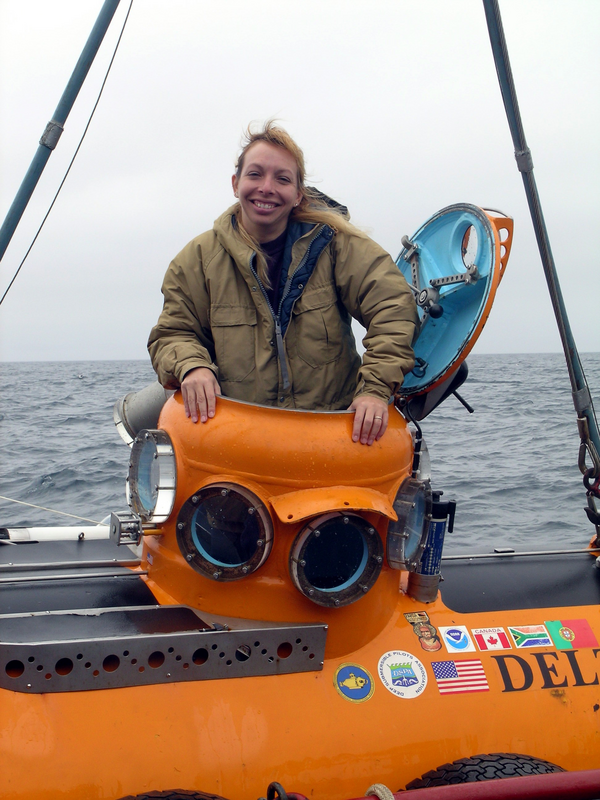
Dr. Christina Kellogg emerges from the submersible Delta
Dr. Christina Kellogg emerges from the submersible DeltaDr. Christina Kellogg emerges from the submersible Delta after collecting coral samples in the Aleutian Islands in 2004.
Dr. Christina Kellogg emerges from the submersible Delta
Dr. Christina Kellogg emerges from the submersible DeltaDr. Christina Kellogg emerges from the submersible Delta after collecting coral samples in the Aleutian Islands in 2004.

Aerial photo shows coastal Florida home damage from Hurricane Jeanne
Aerial photo shows coastal Florida home damage from Hurricane JeannePhotograph of the Florida coastline shows storm damage after Hurricane Jeanne's passage.
Aerial photo shows coastal Florida home damage from Hurricane Jeanne
Aerial photo shows coastal Florida home damage from Hurricane JeannePhotograph of the Florida coastline shows storm damage after Hurricane Jeanne's passage.
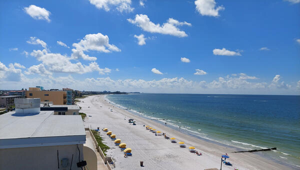
Madeira Beach, Florida
A view taken from a rooftop of Madeira Beach in Florida.
A view taken from a rooftop of Madeira Beach in Florida.
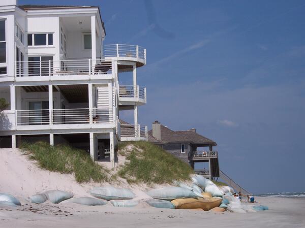
A beach home with exposed support columns at the edge of an eroded dune, Figure Eight Island, NC
A beach home with exposed support columns at the edge of an eroded dune, Figure Eight Island, NCA beach home with exposed support columns at the edge of an eroded dune, Figure Eight Island, NC, 2004. High water at the coast can severely damage beaches and dunes putting coastal homes are risk of being undermined by the removal of sand during storms.

Coral shading experiment during a bleaching event
Here are shown a series of photographs of a rice coral (Montipora capitata) shaded with light filters during a natural “coral bleaching” event observed during anomalously high ocean temperatures in Autumn of 2004 on the island of Oʻahu, Hawaiʻi.
Here are shown a series of photographs of a rice coral (Montipora capitata) shaded with light filters during a natural “coral bleaching” event observed during anomalously high ocean temperatures in Autumn of 2004 on the island of Oʻahu, Hawaiʻi.

Closeup photograph of home damaged by Hurricane Jeanne in Florida
Closeup photograph of home damaged by Hurricane Jeanne in FloridaZoomed in aerial photograph of a home on the beach near Stuart, Florida, severely damaged by Hurricane Jeanne in September 2004.
Closeup photograph of home damaged by Hurricane Jeanne in Florida
Closeup photograph of home damaged by Hurricane Jeanne in FloridaZoomed in aerial photograph of a home on the beach near Stuart, Florida, severely damaged by Hurricane Jeanne in September 2004.
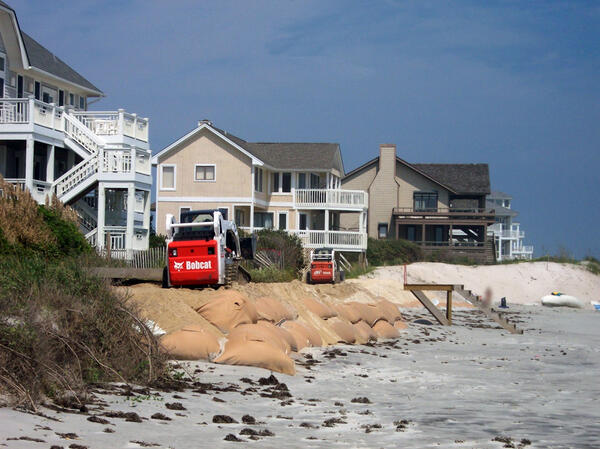
Sandbags serve as a make-shift seawall on Figure Eight Island, NC
Sandbags serve as a make-shift seawall on Figure Eight Island, NCSandbags serve as a make-shift seawall to strengthen the dune and mitigate erosion from future storms. Photo taken on Figure Eight Island, NC.
Sandbags serve as a make-shift seawall on Figure Eight Island, NC
Sandbags serve as a make-shift seawall on Figure Eight Island, NCSandbags serve as a make-shift seawall to strengthen the dune and mitigate erosion from future storms. Photo taken on Figure Eight Island, NC.
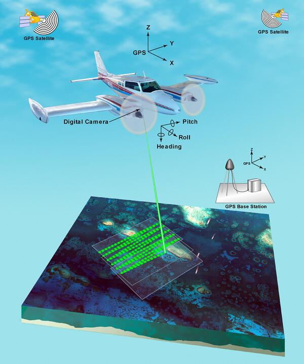
Illustration of airborne lidar acquisition platform
Illustration of airborne lidar acquisition platformAirborne lidar is a surveying method that measures distance to a target from a survey plane by illuminating that target with a pulsed laser light, and measuring the reflected pulses with a sensor. Differences in laser return times and wavelengths can then be used to make digital 3D-representations of the target.

Lidar plane
Airborne lidar is a surveying method that measures distance to a target from a survey plane by illuminating that target with a pulsed laser light, and measuring the reflected pulses with a sensor. Differences in laser return times and wavelengths can then be used to make digital 3D-representations of the target.
Airborne lidar is a surveying method that measures distance to a target from a survey plane by illuminating that target with a pulsed laser light, and measuring the reflected pulses with a sensor. Differences in laser return times and wavelengths can then be used to make digital 3D-representations of the target.

BSC Anchorage
Anchored at the mouth of Big Sable Creek in Everglades National Park preparatory to 4-5 days field work on mangrove-associated fish and terrapins.
Anchored at the mouth of Big Sable Creek in Everglades National Park preparatory to 4-5 days field work on mangrove-associated fish and terrapins.

Yellowtop
Yellowtop in bloom along the roadside, just south of the US 27/I-75 (Alligator
Alley) intersection.
Yellowtop in bloom along the roadside, just south of the US 27/I-75 (Alligator
Alley) intersection.

Panoramic of Biscayne Bay
Facing east, a panoramic view of Biscayne Bay. The mainland is seen at far
right. Biscayne Bay is an estuary, a place where freshwater and salt water
meet. Freshwater flow from the land supplies the bay with nutrients.
Facing east, a panoramic view of Biscayne Bay. The mainland is seen at far
right. Biscayne Bay is an estuary, a place where freshwater and salt water
meet. Freshwater flow from the land supplies the bay with nutrients.