Coastal Sediment Availability and Flux (CSAF)
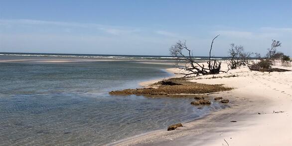
Sediments are the foundation of coastal systems, including barrier islands. Their behavior is driven by not only sediment availability, but also sediment exchanges between barrier island environments. We collect geophysical, remote sensing, and sediment data to estimate these parameters, which are integrated with models to improve prediction of coastal response to extreme storms and sea-level rise.
Barrier Islands as Connected Systems
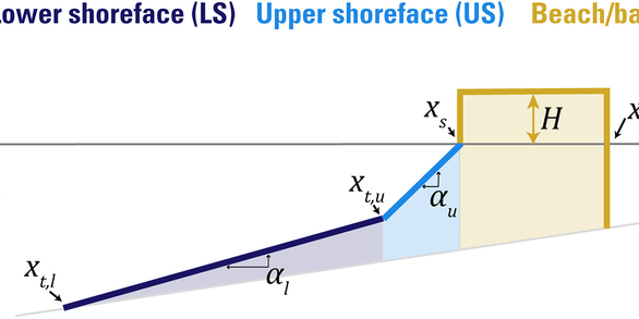
With a wealth of knowledge about how shorelines, beaches, and dunes respond to storms and the variability of inner shelf geology, the USGS Coastal and Marine Hazards and Resources Program is poised to extend its morphologic and geologic expertise across the shoreface and back-barrier data gaps. Shoreface geology is particularly important to assess since it may record evidence of processes that we otherwise don’t have the opportunities or capabilities to observe. With these goals in mind, we measure geology and morphology in coastal environments to reconstruct past environmental histories and estimate the magnitude and rate of sediment exchanges (e.g., fluxes) over a range of time scales. Integration of these observations with models allows us to predict past and future behavior of barrier-island systems in a changing climate and provides information to help our partners mitigate coastal hazards and identify coastal restoration priorities.
Project Objectives:
- Incorporate shoreface morphology and geology into coastal-change assessments
- Conduct repeat geophysical surveys to estimate sediment fluxes with better accuracy and temporal resolution
- Understand how coastal systems respond to storms, variations in sediment supply and rate of sea-level rise over short (1-10s year) and long (100-1000 year) time scales
- Make predictions of future (long-term) coastal vulnerability and resilience rooted in robust morphologic and geologic observations
Learn more about the Coastal Sediment Availability and Flux project
Below are data associated with this project.
Archive of Chirp Subbottom Profile Data Collected in 2022 From Seven Mile Island, New Jersey Archive of Chirp Subbottom Profile Data Collected in 2022 From Seven Mile Island, New Jersey
Coastal Single-beam Bathymetry Data Collected in 2022 off Seven Mile Island, New Jersey Coastal Single-beam Bathymetry Data Collected in 2022 off Seven Mile Island, New Jersey
Numerical model of coastal Erosion by Waves and Transgressive Scarps (NEWTS) Numerical model of coastal Erosion by Waves and Transgressive Scarps (NEWTS)
Sediment Data From Vibracores and Sand Augers Collected in 2021 and 2022 From Fire Island, New York Sediment Data From Vibracores and Sand Augers Collected in 2021 and 2022 From Fire Island, New York
Ground Penetrating Radar and Global Positioning System Data Collected in 2021 From Fire Island, New York Ground Penetrating Radar and Global Positioning System Data Collected in 2021 From Fire Island, New York
Coastal Multibeam Bathymetry and Backscatter Data Collected in May 2021 from Seven Mile Island, New Jersey Coastal Multibeam Bathymetry and Backscatter Data Collected in May 2021 from Seven Mile Island, New Jersey
Coastal Bathymetry and Backscatter Data Collected in June 2021 from Rockaway Peninsula, New York Coastal Bathymetry and Backscatter Data Collected in June 2021 from Rockaway Peninsula, New York
Grain-Size Data From Sediment Samples at Seven Mile Island, New Jersey and Rockaway Peninsula, New York Grain-Size Data From Sediment Samples at Seven Mile Island, New Jersey and Rockaway Peninsula, New York
Coastal Land-Cover and Feature Datasets Extracted from Landsat Satellite Imagery, Northern Chandeleur Islands, Louisiana Coastal Land-Cover and Feature Datasets Extracted from Landsat Satellite Imagery, Northern Chandeleur Islands, Louisiana
Archive of Chirp Subbottom Profile Data Collected in 2019 From Rockaway Peninsula, New York Archive of Chirp Subbottom Profile Data Collected in 2019 From Rockaway Peninsula, New York
Coastal Bathymetry and Backscatter Data Collected in September-October 2019 from Rockaway Peninsula, New York Coastal Bathymetry and Backscatter Data Collected in September-October 2019 from Rockaway Peninsula, New York
Archive of Chirp Subbottom Profile Data Collected in 2019 From Cedar Island, Virginia Archive of Chirp Subbottom Profile Data Collected in 2019 From Cedar Island, Virginia
Secrets of the Sediment on Barrier Islands
Join the USGS St. Petersburg Coastal and Marine Science Center as they uncover the secrets of the sediment on barrier islands in Pinellas County, Florida. This video was originally created for use at the 2021 virtual St. Petersburg Science Festival. Listen to audio-described version.
Below are publications associated with this project.
Barrier island geomorphic complexity drives storm and post-storm response Barrier island geomorphic complexity drives storm and post-storm response
Integrating geophysical and oceanographic data to assess interannual variability in longshore sediment transport Integrating geophysical and oceanographic data to assess interannual variability in longshore sediment transport
Articulated Barrier Shoreface (ABSF) Model Articulated Barrier Shoreface (ABSF) Model
Python-based Subaerial Barrier Sediment Partitioning (pySBSP) model (ver. 1.0, February 2024) Python-based Subaerial Barrier Sediment Partitioning (pySBSP) model (ver. 1.0, February 2024)
Numerical model of coastal Erosion by Waves and Transgressive Scarps (NEWTS) Numerical model of coastal Erosion by Waves and Transgressive Scarps (NEWTS)
Subaerial Barrier Sediment Partitioning (SBSP) Model Version 1.0 Subaerial Barrier Sediment Partitioning (SBSP) Model Version 1.0
Below are news stories associated with this project.
USGS Awarded NOAA Effects of Sea Level Rise (ESLR) Grant USGS Awarded NOAA Effects of Sea Level Rise (ESLR) Grant
Sediments are the foundation of coastal systems, including barrier islands. Their behavior is driven by not only sediment availability, but also sediment exchanges between barrier island environments. We collect geophysical, remote sensing, and sediment data to estimate these parameters, which are integrated with models to improve prediction of coastal response to extreme storms and sea-level rise.
Barrier Islands as Connected Systems
With a wealth of knowledge about how shorelines, beaches, and dunes respond to storms and the variability of inner shelf geology, the USGS Coastal and Marine Hazards and Resources Program is poised to extend its morphologic and geologic expertise across the shoreface and back-barrier data gaps. Shoreface geology is particularly important to assess since it may record evidence of processes that we otherwise don’t have the opportunities or capabilities to observe. With these goals in mind, we measure geology and morphology in coastal environments to reconstruct past environmental histories and estimate the magnitude and rate of sediment exchanges (e.g., fluxes) over a range of time scales. Integration of these observations with models allows us to predict past and future behavior of barrier-island systems in a changing climate and provides information to help our partners mitigate coastal hazards and identify coastal restoration priorities.
Project Objectives:
- Incorporate shoreface morphology and geology into coastal-change assessments
- Conduct repeat geophysical surveys to estimate sediment fluxes with better accuracy and temporal resolution
- Understand how coastal systems respond to storms, variations in sediment supply and rate of sea-level rise over short (1-10s year) and long (100-1000 year) time scales
- Make predictions of future (long-term) coastal vulnerability and resilience rooted in robust morphologic and geologic observations
Learn more about the Coastal Sediment Availability and Flux project
Below are data associated with this project.
Archive of Chirp Subbottom Profile Data Collected in 2022 From Seven Mile Island, New Jersey Archive of Chirp Subbottom Profile Data Collected in 2022 From Seven Mile Island, New Jersey
Coastal Single-beam Bathymetry Data Collected in 2022 off Seven Mile Island, New Jersey Coastal Single-beam Bathymetry Data Collected in 2022 off Seven Mile Island, New Jersey
Numerical model of coastal Erosion by Waves and Transgressive Scarps (NEWTS) Numerical model of coastal Erosion by Waves and Transgressive Scarps (NEWTS)
Sediment Data From Vibracores and Sand Augers Collected in 2021 and 2022 From Fire Island, New York Sediment Data From Vibracores and Sand Augers Collected in 2021 and 2022 From Fire Island, New York
Ground Penetrating Radar and Global Positioning System Data Collected in 2021 From Fire Island, New York Ground Penetrating Radar and Global Positioning System Data Collected in 2021 From Fire Island, New York
Coastal Multibeam Bathymetry and Backscatter Data Collected in May 2021 from Seven Mile Island, New Jersey Coastal Multibeam Bathymetry and Backscatter Data Collected in May 2021 from Seven Mile Island, New Jersey
Coastal Bathymetry and Backscatter Data Collected in June 2021 from Rockaway Peninsula, New York Coastal Bathymetry and Backscatter Data Collected in June 2021 from Rockaway Peninsula, New York
Grain-Size Data From Sediment Samples at Seven Mile Island, New Jersey and Rockaway Peninsula, New York Grain-Size Data From Sediment Samples at Seven Mile Island, New Jersey and Rockaway Peninsula, New York
Coastal Land-Cover and Feature Datasets Extracted from Landsat Satellite Imagery, Northern Chandeleur Islands, Louisiana Coastal Land-Cover and Feature Datasets Extracted from Landsat Satellite Imagery, Northern Chandeleur Islands, Louisiana
Archive of Chirp Subbottom Profile Data Collected in 2019 From Rockaway Peninsula, New York Archive of Chirp Subbottom Profile Data Collected in 2019 From Rockaway Peninsula, New York
Coastal Bathymetry and Backscatter Data Collected in September-October 2019 from Rockaway Peninsula, New York Coastal Bathymetry and Backscatter Data Collected in September-October 2019 from Rockaway Peninsula, New York
Archive of Chirp Subbottom Profile Data Collected in 2019 From Cedar Island, Virginia Archive of Chirp Subbottom Profile Data Collected in 2019 From Cedar Island, Virginia
Secrets of the Sediment on Barrier Islands
Join the USGS St. Petersburg Coastal and Marine Science Center as they uncover the secrets of the sediment on barrier islands in Pinellas County, Florida. This video was originally created for use at the 2021 virtual St. Petersburg Science Festival. Listen to audio-described version.
Below are publications associated with this project.
Barrier island geomorphic complexity drives storm and post-storm response Barrier island geomorphic complexity drives storm and post-storm response
Integrating geophysical and oceanographic data to assess interannual variability in longshore sediment transport Integrating geophysical and oceanographic data to assess interannual variability in longshore sediment transport
Articulated Barrier Shoreface (ABSF) Model Articulated Barrier Shoreface (ABSF) Model
Python-based Subaerial Barrier Sediment Partitioning (pySBSP) model (ver. 1.0, February 2024) Python-based Subaerial Barrier Sediment Partitioning (pySBSP) model (ver. 1.0, February 2024)
Numerical model of coastal Erosion by Waves and Transgressive Scarps (NEWTS) Numerical model of coastal Erosion by Waves and Transgressive Scarps (NEWTS)
Subaerial Barrier Sediment Partitioning (SBSP) Model Version 1.0 Subaerial Barrier Sediment Partitioning (SBSP) Model Version 1.0
Below are news stories associated with this project.