An official website of the United States government
Here's how you know
Official websites use .gov
A .gov website belongs to an official government organization in the United States.
Secure .gov websites use HTTPS
A lock () or https:// means you’ve safely connected to the .gov website. Share sensitive information only on official, secure websites.
Edge-of-field monitoring focuses on identifying and reducing agricultural sources of excess nutrients which can threaten the health of streams, rivers, and lakes. Edge-of-field monitoring assesses the quantity and quality of agricultural runoff and evaluates the effectiveness of conservation practices that aim to reduce nutrient loss.
Edge-of-field (EOF) monitoring sites are installed at the edge of agricultural fields, either on the field surface or using subsurface tiles, where runoff can be intercepted and channeled through monitoring equipment before it enters the natural stream system. EOF sites monitor both runoff quantity and quality.
EOF monitoring often uses a nested-basin study design where both individual field runoff and larger subbasin streams are monitored. By monitoring at multiple scales, both the immediate effect of a conservation practice on a single field and the cumulative effect on the larger watershed can be evaluated. Year-round monitoring utilizes natural rainfall/snowmelt conditions to measure not only the quantity of nutrient loss but also the timing. This information allows event-timing-based options for strategic nutrient application and adaptive implementation to be evaluated.
The edge-of-field monitoring nested-basin design includes monitoring runoff at multiple scales. This includes evaluating conservation-practice effectiveness at individual field basins in addition to monitoring water-quality changes at the stream scale (at a USGS streamgage at the outflow of the study subbasin). Nested edge-of-field sites often monitor changes before and after a conservation practice is installed, and/or comparisons are made between treatment and control basins (a paired-basin study).
Historically, monitoring for conservation-practice assessment has been done at the watershed scale, but those evaluations are often complicated by land-use variability and in-stream processes, which often require a long study duration. By monitoring runoff from an individual field, we can evaluate the direct impacts of agricultural activities and the effectiveness of conservation practices. The benefits of EOF monitoring include:
Direct relations of nutrient sources and transport
Quantification of the effects of field activities and conservation practice implementation
Improved nutrient loss and conservation-practice impact modeling
Shorter study duration due to field-focused monitoring scale
Increased producer involvement
Provides information for management decisions, adaptive management, and outreach
WHAT DOES EOF MEASURE?
Data collected at edge-of-field sites includes:
Runoff quantity and flow - determines how much water passes by each site
Meteorological data - precipitation, air temperature, relative humidity, solar radiation, soil temperature, and soil moisture
In-situ water quality - temperature, pH, specific conductance, dissolved oxygen, turbidity, nitrate and phosphate (via sensors)
Sediment and nutrients - samples are analyzed for suspended sediment, chloride, nitrate plus nitrite, ammonium, total Kjeldahl nitrogen, orthophosphate, and total phosphorus
Loads and yields are calculated by combining sample concentrations and runoff quantity to determine the amount of each consituent leaving the field. This is critical for evaluating the effectiveness of conservation practices.
This image shows an example hydrograph showing how the discharge, or volume of water passing through a streamgage (red line), changes as the result of accumulating rainfall (blue dotted line). The bottles shown are the water-quality samples collected at each time point (green circles), showing the discharge response and variability in sediment and nutrient concentrations of water samples collected during an edge-of-field runoff event.
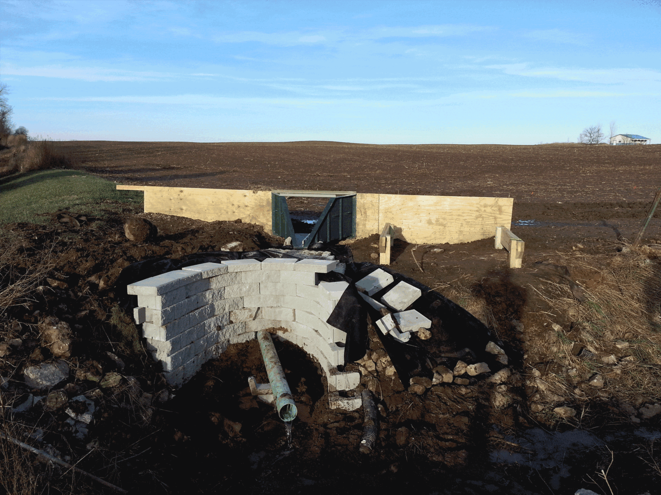
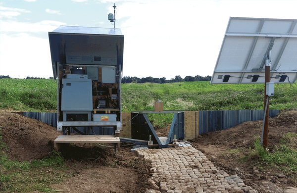
Surface EOF monitoring sites are located in areas where runoff exits agricultural fields or in nearby streams where the fields directly drain. A typical EOF surface site consists of:
Wingwalls - plywood or steel sheet piling combined with earthen berms are used to direct runoff
H flume - runoff control structure
Water quantity monitoring equipment - records water levels
Refrigerated water-quality sampler - collects and stores water samples during runoff events
Two-way communication and datalogger capabilities - provides direct control over the monitoring equipment for flexible, year-round at varying scales, locations, setting, and conditions
Power - power is needed for year-round operation, including sample refrigeration in the summer and heat tape in the winter. Power is provided by A/C, if available, or through the use of solar equipment at remote sites
Digital camera - remotely captures field conditions, records staff readings to verify flow data, and communicates site conditions to reduce personnel time and improve data accuracy
Subsurface tile EOF monitoring sites are typically located at drainage tile outlets, in a ditch or stream, or in-line with the subsurface tile system. A typical EOF subsurface tile site consists of the same equipment as the surface sites with some differences due to the requirements of the subsurface location:
Flow control structure - a modified commercially available product to include a sharp-crested V-notch weir to measure subsurface tile runoff. Water depth measurements and water-quality samples are also taken inside the flow control structure
Subsurface tile - artificial drainage placed within the field 3 to 4 feet below the surface
Velocity meter - instrument used to measure velocity in the subsurface tile when backwater affects the flow control structure
FLEXIBLE MONITORING STRATEGIES
Like any monitoring effort, EOF has its challenges, and the USGS collaborates with producers and partners to develop rigorous monitoring strategies that are both flexible and adaptable. Each site brings its own complexities and opportunities, such as:
Sites are usually located on private farms and are often inaccessible by road, so equipment must be easily transportable and minimally invasive while meeting unique project goals, landowner concerns, and limited budgets.
EOF monitoring occurs year-round under all weather conditions, so the ability to adjust to changing runoff conditions and weather while minimizing the need for on-site personnel trips is key.
Alternative monitoring methods (such as the use of real-time water-quality sensors, different sample collection strategies, or a depth-integrated sampling arm) can potentially improve data quality or reduce costs.
Great Lakes Restoration Initiative edge-of-field monitoring focuses on identifying and reducing agricultural sources of excess nutrients which threaten the health of the Great Lakes. The USGS supports these efforts by utilizing edge-of-field monitoring to assess the quantity and quality of agricultural runoff and evaluate conservation practices that aim to reduce sediment and nutrient loss.
Edge-of-field monitoring: Great Lakes Restoration Initiative (GLRI)
Great Lakes Restoration Initiative edge-of-field monitoring focuses on identifying and reducing agricultural sources of excess nutrients which threaten the health of the Great Lakes. The USGS supports these efforts by utilizing edge-of-field monitoring to assess the quantity and quality of agricultural runoff and evaluate conservation practices that aim to reduce sediment and nutrient loss.
The USGS is cooperating with Discovery Farms to understand agriculture’s impact on the environment and help producers find ways to minimize their impact while remaining economically viable. Edge-of-field or subsurface tile monitoring stations measure runoff-event volume, including snowmelt, and collect samples which are analyzed for suspended sediment, phosphorus, nitrogen, and chloride.
The USGS is cooperating with Discovery Farms to understand agriculture’s impact on the environment and help producers find ways to minimize their impact while remaining economically viable. Edge-of-field or subsurface tile monitoring stations measure runoff-event volume, including snowmelt, and collect samples which are analyzed for suspended sediment, phosphorus, nitrogen, and chloride.
Edge-of-field: runoff before and after conservation practice install
These photos, taken before and after a grassed-waterway conservation practice was installed, show a change in the water clarity of agricultural runoff at an edge-of-field surface monitoring site in Wisconsin.
These photos, taken before and after a grassed-waterway conservation practice was installed, show a change in the water clarity of agricultural runoff at an edge-of-field surface monitoring site in Wisconsin.
These photos show various edge-of-field monitoring surface and subsurface monitoring sites, installation efforts, and runoff events across the Great Lakes basin.
These photos show various edge-of-field monitoring surface and subsurface monitoring sites, installation efforts, and runoff events across the Great Lakes basin.
Edge-of-Field Monitoring Using Depth-Integrated Sample Arm (DISA)
During edge-of-field monitoring of an agricultural field runoff event, a depth-integrated sample arm (DISA) is used to take a water sample at the same time a traditional water sample is taken from an intake located at the bottom of the H-flume exit, where the water is assumed to be completely mixed.
During edge-of-field monitoring of an agricultural field runoff event, a depth-integrated sample arm (DISA) is used to take a water sample at the same time a traditional water sample is taken from an intake located at the bottom of the H-flume exit, where the water is assumed to be completely mixed.
Time-Lapse of Edge-of-Field Event Near Fort Wayne, IN
Time-lapse photo of a rainfall-induced runoff event at an edge-of-field surface site near Fort Wayne, Indiana, on May 10-11, 2016. Edge-of-field monitoring is used to assess the quantity and quality of agricultural runoff and evaluate the effectiveness of conservation practices that aim to reduce nutrient loss.
Time-lapse photo of a rainfall-induced runoff event at an edge-of-field surface site near Fort Wayne, Indiana, on May 10-11, 2016. Edge-of-field monitoring is used to assess the quantity and quality of agricultural runoff and evaluate the effectiveness of conservation practices that aim to reduce nutrient loss.
The Great Lakes face a number of serious challenges that cause damage to water quality, habitat, ecology, and coastal health. Excess nutrients from point and nonpoint sources have a history of causing harmful algal blooms (HABs); since the late 1990s, a resurgence of HABs have forced beach closures and resulted in water quality impairments across the Great Lakes. Studies increasingly...
Introduction The Great Lakes face a number of serious challenges that cause damage to water quality, habitat, ecology, and coastal health. Excess nutrients from point and nonpoint sources have a history of causing harmful algal blooms (HABs); since the late 1990s, a resurgence of HABs have forced beach closures and resulted in water quality impairments across the Great Lakes. Studies...
Introduction The Great Lakes face a number of serious challenges that cause damage to water quality, habitat, ecology, and coastal health. Excess nutrients from point and nonpoint sources have a history of causing harmful algal blooms (HABs); since the late 1990s, a resurgence of HABs have forced beach closures and resulted in water quality impairments across the Great Lakes. Studies...
The University of Wisconsin (UW)-Madison Discovery Farms (Discovery Farms) and UW-Platteville Pioneer Farm (Pioneer Farm) programs were created in 2000 to help Wisconsin farmers meet environmental and economic challenges. As a partner with each program, and in cooperation with the Wisconsin Department of Natural Resources and the Sand County Foundation, the U.S. Geological Survey (USGS)...
Authors
Todd D. Stuntebeck, Matthew J. Komiskey, David W. Owens, David W. Hall
The GLRI Edge-of-Field Monitoring project focuses on identifying and reducing agricultural sources of excess nutrients which can threaten the health of the Great Lakes. This geonarrative details the basics of edge-of-field monitoring (EOF), explores EOF applications, shows USGS is working collaboratively with our partners, and discusses how EOF can improve conservation efforts.
Edge-of-field monitoring focuses on identifying and reducing agricultural sources of excess nutrients which can threaten the health of streams, rivers, and lakes. Edge-of-field monitoring assesses the quantity and quality of agricultural runoff and evaluates the effectiveness of conservation practices that aim to reduce nutrient loss.
Edge-of-field (EOF) monitoring sites are installed at the edge of agricultural fields, either on the field surface or using subsurface tiles, where runoff can be intercepted and channeled through monitoring equipment before it enters the natural stream system. EOF sites monitor both runoff quantity and quality.
EOF monitoring often uses a nested-basin study design where both individual field runoff and larger subbasin streams are monitored. By monitoring at multiple scales, both the immediate effect of a conservation practice on a single field and the cumulative effect on the larger watershed can be evaluated. Year-round monitoring utilizes natural rainfall/snowmelt conditions to measure not only the quantity of nutrient loss but also the timing. This information allows event-timing-based options for strategic nutrient application and adaptive implementation to be evaluated.
The edge-of-field monitoring nested-basin design includes monitoring runoff at multiple scales. This includes evaluating conservation-practice effectiveness at individual field basins in addition to monitoring water-quality changes at the stream scale (at a USGS streamgage at the outflow of the study subbasin). Nested edge-of-field sites often monitor changes before and after a conservation practice is installed, and/or comparisons are made between treatment and control basins (a paired-basin study).
Historically, monitoring for conservation-practice assessment has been done at the watershed scale, but those evaluations are often complicated by land-use variability and in-stream processes, which often require a long study duration. By monitoring runoff from an individual field, we can evaluate the direct impacts of agricultural activities and the effectiveness of conservation practices. The benefits of EOF monitoring include:
Direct relations of nutrient sources and transport
Quantification of the effects of field activities and conservation practice implementation
Improved nutrient loss and conservation-practice impact modeling
Shorter study duration due to field-focused monitoring scale
Increased producer involvement
Provides information for management decisions, adaptive management, and outreach
WHAT DOES EOF MEASURE?
Data collected at edge-of-field sites includes:
Runoff quantity and flow - determines how much water passes by each site
Meteorological data - precipitation, air temperature, relative humidity, solar radiation, soil temperature, and soil moisture
In-situ water quality - temperature, pH, specific conductance, dissolved oxygen, turbidity, nitrate and phosphate (via sensors)
Sediment and nutrients - samples are analyzed for suspended sediment, chloride, nitrate plus nitrite, ammonium, total Kjeldahl nitrogen, orthophosphate, and total phosphorus
Loads and yields are calculated by combining sample concentrations and runoff quantity to determine the amount of each consituent leaving the field. This is critical for evaluating the effectiveness of conservation practices.
This image shows an example hydrograph showing how the discharge, or volume of water passing through a streamgage (red line), changes as the result of accumulating rainfall (blue dotted line). The bottles shown are the water-quality samples collected at each time point (green circles), showing the discharge response and variability in sediment and nutrient concentrations of water samples collected during an edge-of-field runoff event.
Surface EOF monitoring sites are located in areas where runoff exits agricultural fields or in nearby streams where the fields directly drain. A typical EOF surface site consists of:
Wingwalls - plywood or steel sheet piling combined with earthen berms are used to direct runoff
H flume - runoff control structure
Water quantity monitoring equipment - records water levels
Refrigerated water-quality sampler - collects and stores water samples during runoff events
Two-way communication and datalogger capabilities - provides direct control over the monitoring equipment for flexible, year-round at varying scales, locations, setting, and conditions
Power - power is needed for year-round operation, including sample refrigeration in the summer and heat tape in the winter. Power is provided by A/C, if available, or through the use of solar equipment at remote sites
Digital camera - remotely captures field conditions, records staff readings to verify flow data, and communicates site conditions to reduce personnel time and improve data accuracy
Subsurface tile EOF monitoring sites are typically located at drainage tile outlets, in a ditch or stream, or in-line with the subsurface tile system. A typical EOF subsurface tile site consists of the same equipment as the surface sites with some differences due to the requirements of the subsurface location:
Flow control structure - a modified commercially available product to include a sharp-crested V-notch weir to measure subsurface tile runoff. Water depth measurements and water-quality samples are also taken inside the flow control structure
Subsurface tile - artificial drainage placed within the field 3 to 4 feet below the surface
Velocity meter - instrument used to measure velocity in the subsurface tile when backwater affects the flow control structure
FLEXIBLE MONITORING STRATEGIES
Like any monitoring effort, EOF has its challenges, and the USGS collaborates with producers and partners to develop rigorous monitoring strategies that are both flexible and adaptable. Each site brings its own complexities and opportunities, such as:
Sites are usually located on private farms and are often inaccessible by road, so equipment must be easily transportable and minimally invasive while meeting unique project goals, landowner concerns, and limited budgets.
EOF monitoring occurs year-round under all weather conditions, so the ability to adjust to changing runoff conditions and weather while minimizing the need for on-site personnel trips is key.
Alternative monitoring methods (such as the use of real-time water-quality sensors, different sample collection strategies, or a depth-integrated sampling arm) can potentially improve data quality or reduce costs.
Great Lakes Restoration Initiative edge-of-field monitoring focuses on identifying and reducing agricultural sources of excess nutrients which threaten the health of the Great Lakes. The USGS supports these efforts by utilizing edge-of-field monitoring to assess the quantity and quality of agricultural runoff and evaluate conservation practices that aim to reduce sediment and nutrient loss.
Edge-of-field monitoring: Great Lakes Restoration Initiative (GLRI)
Great Lakes Restoration Initiative edge-of-field monitoring focuses on identifying and reducing agricultural sources of excess nutrients which threaten the health of the Great Lakes. The USGS supports these efforts by utilizing edge-of-field monitoring to assess the quantity and quality of agricultural runoff and evaluate conservation practices that aim to reduce sediment and nutrient loss.
The USGS is cooperating with Discovery Farms to understand agriculture’s impact on the environment and help producers find ways to minimize their impact while remaining economically viable. Edge-of-field or subsurface tile monitoring stations measure runoff-event volume, including snowmelt, and collect samples which are analyzed for suspended sediment, phosphorus, nitrogen, and chloride.
The USGS is cooperating with Discovery Farms to understand agriculture’s impact on the environment and help producers find ways to minimize their impact while remaining economically viable. Edge-of-field or subsurface tile monitoring stations measure runoff-event volume, including snowmelt, and collect samples which are analyzed for suspended sediment, phosphorus, nitrogen, and chloride.
Edge-of-field: runoff before and after conservation practice install
These photos, taken before and after a grassed-waterway conservation practice was installed, show a change in the water clarity of agricultural runoff at an edge-of-field surface monitoring site in Wisconsin.
These photos, taken before and after a grassed-waterway conservation practice was installed, show a change in the water clarity of agricultural runoff at an edge-of-field surface monitoring site in Wisconsin.
These photos show various edge-of-field monitoring surface and subsurface monitoring sites, installation efforts, and runoff events across the Great Lakes basin.
These photos show various edge-of-field monitoring surface and subsurface monitoring sites, installation efforts, and runoff events across the Great Lakes basin.
Edge-of-Field Monitoring Using Depth-Integrated Sample Arm (DISA)
During edge-of-field monitoring of an agricultural field runoff event, a depth-integrated sample arm (DISA) is used to take a water sample at the same time a traditional water sample is taken from an intake located at the bottom of the H-flume exit, where the water is assumed to be completely mixed.
During edge-of-field monitoring of an agricultural field runoff event, a depth-integrated sample arm (DISA) is used to take a water sample at the same time a traditional water sample is taken from an intake located at the bottom of the H-flume exit, where the water is assumed to be completely mixed.
Edge-of-Field Monitoring Using Depth-Integrated Sample Arm (DISA)
During edge-of-field monitoring of an agricultural field runoff event, a depth-integrated sample arm (DISA) is used to take a water sample at the same time a traditional water sample is taken from an intake located at the bottom of the H-flume exit, where the water is assumed to be completely mixed.
During edge-of-field monitoring of an agricultural field runoff event, a depth-integrated sample arm (DISA) is used to take a water sample at the same time a traditional water sample is taken from an intake located at the bottom of the H-flume exit, where the water is assumed to be completely mixed.
Time-Lapse of Edge-of-Field Event Near Fort Wayne, IN
Time-lapse photo of a rainfall-induced runoff event at an edge-of-field surface site near Fort Wayne, Indiana, on May 10-11, 2016. Edge-of-field monitoring is used to assess the quantity and quality of agricultural runoff and evaluate the effectiveness of conservation practices that aim to reduce nutrient loss.
Time-lapse photo of a rainfall-induced runoff event at an edge-of-field surface site near Fort Wayne, Indiana, on May 10-11, 2016. Edge-of-field monitoring is used to assess the quantity and quality of agricultural runoff and evaluate the effectiveness of conservation practices that aim to reduce nutrient loss.
Time-Lapse of Edge-of-Field Event Near Fort Wayne, IN
Time-lapse photo of a rainfall-induced runoff event at an edge-of-field surface site near Fort Wayne, Indiana, on May 10-11, 2016. Edge-of-field monitoring is used to assess the quantity and quality of agricultural runoff and evaluate the effectiveness of conservation practices that aim to reduce nutrient loss.
Time-lapse photo of a rainfall-induced runoff event at an edge-of-field surface site near Fort Wayne, Indiana, on May 10-11, 2016. Edge-of-field monitoring is used to assess the quantity and quality of agricultural runoff and evaluate the effectiveness of conservation practices that aim to reduce nutrient loss.
The Great Lakes face a number of serious challenges that cause damage to water quality, habitat, ecology, and coastal health. Excess nutrients from point and nonpoint sources have a history of causing harmful algal blooms (HABs); since the late 1990s, a resurgence of HABs have forced beach closures and resulted in water quality impairments across the Great Lakes. Studies increasingly...
Introduction The Great Lakes face a number of serious challenges that cause damage to water quality, habitat, ecology, and coastal health. Excess nutrients from point and nonpoint sources have a history of causing harmful algal blooms (HABs); since the late 1990s, a resurgence of HABs have forced beach closures and resulted in water quality impairments across the Great Lakes. Studies...
Introduction The Great Lakes face a number of serious challenges that cause damage to water quality, habitat, ecology, and coastal health. Excess nutrients from point and nonpoint sources have a history of causing harmful algal blooms (HABs); since the late 1990s, a resurgence of HABs have forced beach closures and resulted in water quality impairments across the Great Lakes. Studies...
The University of Wisconsin (UW)-Madison Discovery Farms (Discovery Farms) and UW-Platteville Pioneer Farm (Pioneer Farm) programs were created in 2000 to help Wisconsin farmers meet environmental and economic challenges. As a partner with each program, and in cooperation with the Wisconsin Department of Natural Resources and the Sand County Foundation, the U.S. Geological Survey (USGS)...
Authors
Todd D. Stuntebeck, Matthew J. Komiskey, David W. Owens, David W. Hall
The GLRI Edge-of-Field Monitoring project focuses on identifying and reducing agricultural sources of excess nutrients which can threaten the health of the Great Lakes. This geonarrative details the basics of edge-of-field monitoring (EOF), explores EOF applications, shows USGS is working collaboratively with our partners, and discusses how EOF can improve conservation efforts.


")
