
Lake Accotink Sedimentation Study
Lake Accotink is a 55-acre lake in Fairfax County which is highly valued by the local community. Much like a living organism, lakes go through many changes. Several factors affect their health and well-being such as sediment buildup. As the lake fills with sediment, it loses surface area and volume.
Lake Accotink has been dredged in the past to remove excess sediment, but this process is costly, disruptive to nearby communities, and can negatively affect the natural resources of the lake and surrounding area. The areas upstream were heavily developed prior to Virginia stormwater management regulations and have increased water flow in Accotink Creek, transporting significant sediment to the lake, making regular dredging to maintain its current size potentially unsustainable.
The lake is fed by Accotink Creek, including the Long Branch tributary. Long Branch delivers a disproportionately large amount of sediment relative to its size. The USGS is monitoring Lake Accotink, Accotink Creek, and Long Branch to better understand sediment flow into and out of the lake. This information will assist Fairfax County in preserving a smaller Lake Accotink for the foreseeable future.
Table of Contents
Introduction: The Issue of Sedimentation
Sedimentation is an issue affecting Lake Accotink. Sediments are eroded from various locations within the watershed and transported downstream by flowing water. Sources of sediment include streambanks, the streambed, floodplain soils, and upland soils. The largest movements of sediment in the watershed tend to occur during storms.

When the water carrying these sediments reaches the lake, the water slows down. This reduced speed allows some larger, heavier sediment to settle on the lakebed, while other smaller sediment particles may remain suspended and flow past the dam into the downstream portion of Accotink Creek.

As sediments accumulate in the lake, its surface area and volume decreases.

Goals of this Study
This study has two different aspects: understanding sediment behavior in both Lake Accotink and in Accotink Creek. The Lake Accotink Sedimentation Study is designed to examine sediment behavior in Lake Accotink, focusing on how quickly the lake fills with sediment. The Accotink Creek study examines sediment behavior in Accotink Creek, including the Long Branch tributary, and identifies sources of sediment in the creek.
To answer these questions, the USGS is doing the following:
Lake Accotink Sedimentation Study:
- Collect data needed to calculate annual loads of suspended sediment transported below Lake Accotink
- Collect data needed to calculate bedload above Lake Accotink
- Compute the annual total sediment load above Lake Accotink and suspended sediment load below Lake Accotink
- Develop a sediment mass-balance for Lake Accotink
Accotink Creek Study:
- Identify and measure sources and sinks of sediment in Accotink Creek
- Monitor changes in channel shape at multiple locations in Accotink Creek
- Develop a sediment budget for Accotink Creek
- Collect data needed to calculate annual loads of nitrogen, phosphorus, and major ions transported below Lake Accotink
- Calculate annual loads of nutrients and major ions below Lake Accotink
Title
Title
Webcams
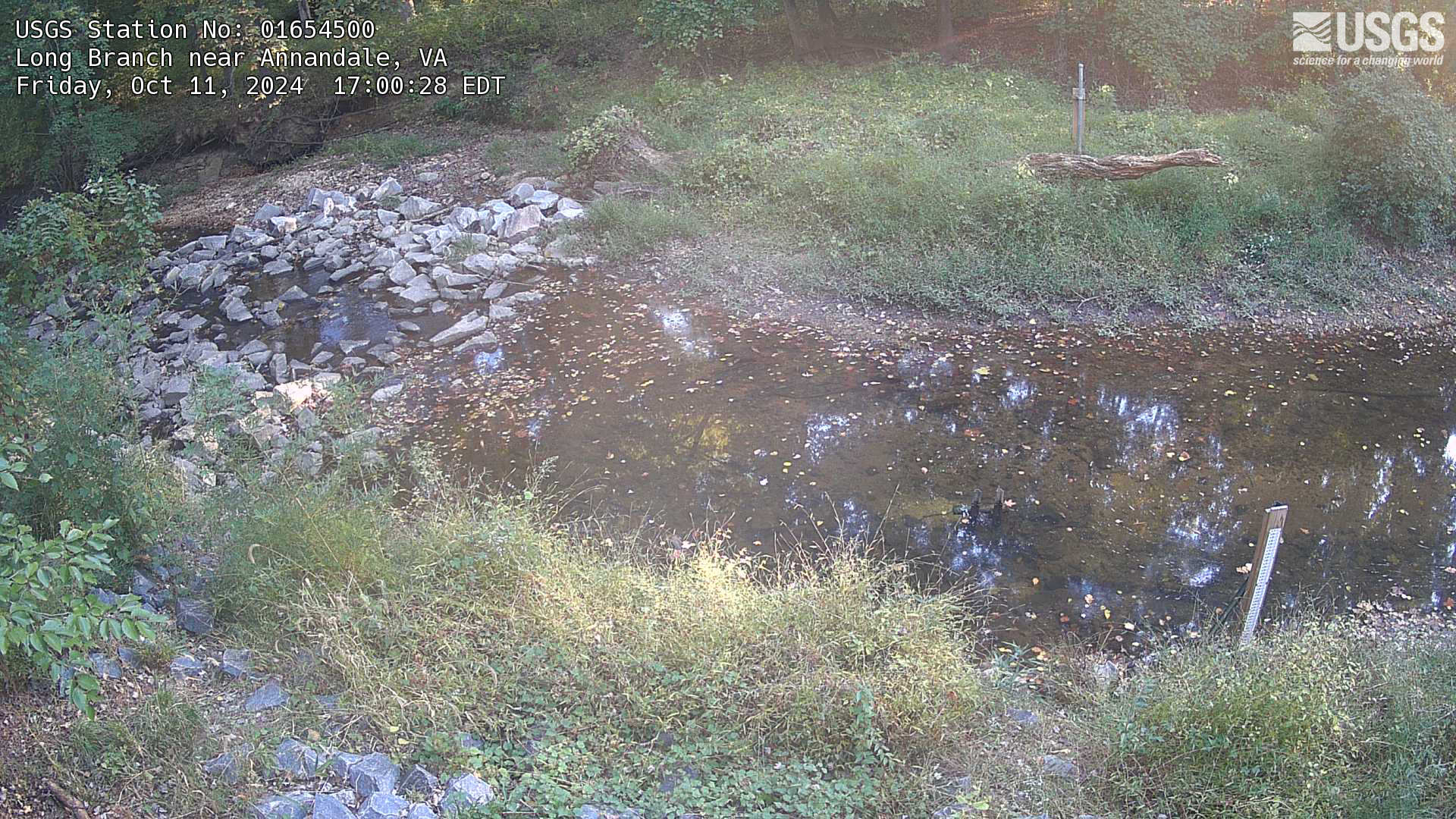
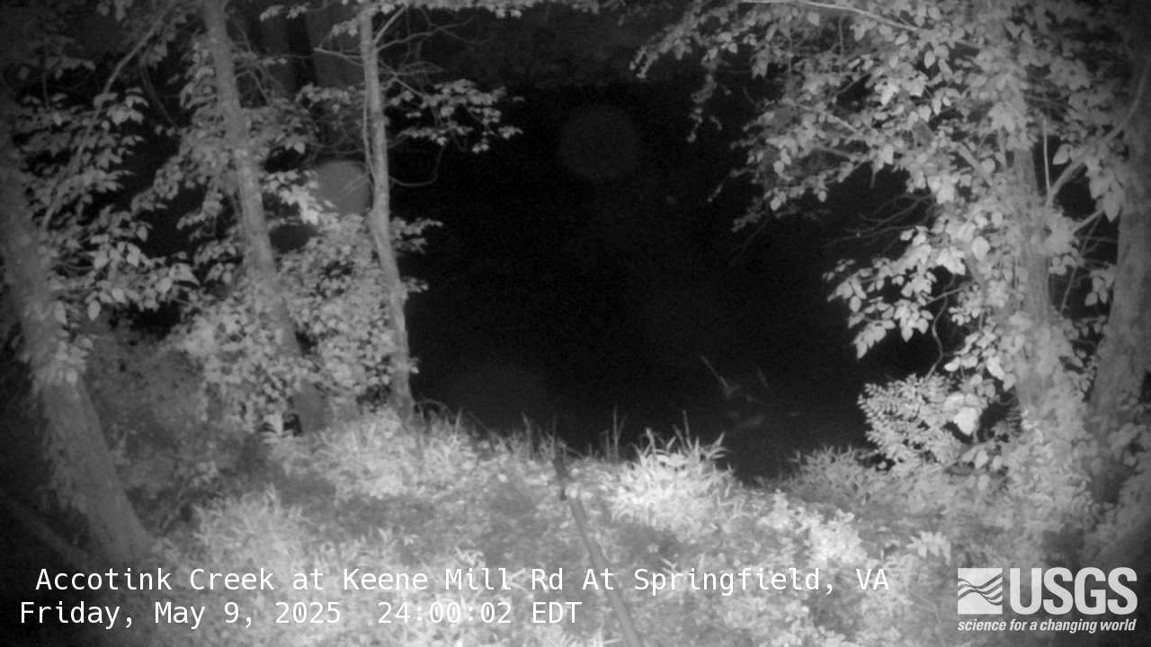
Two of the three Accotink Project monitoring locations, Long Branch and Accotink Creek below Lake Accotink, are equipped with cameras that provide regular imagery of stream conditions.
Long Branch above the Lake
Accotink Creek below the Lake

Lake Accotink Study
Continuous monitoring of water quantity and quality, as well as discrete measurements of suspended sediment, is being conducted at the two main tributaries flowing into Lake Accotink and at a site downstream of the lake. The difference in the amount of sediment entering and exiting the lake serves as an indicator of sediment storage within the lake. By understanding the lake's volume and the rate of sediment accumulation, we can estimate how quickly the lake will fill up or require dredging.
Accotink Creek Study

Erosion can change the shape of a stream channel, usually by eroding its banks. Urban streams experiencing bank erosion often have concave banks, such as those seen in many areas of Accotink Creek.
Bank erosion is often a major source of sediment. As the banks erode, the sediment that once made up the banks is carried downstream. Some of this sediment might be deposited on floodplains, which prevents it from being carried downstream into Lake Accotink. Understanding which reaches of Accotink Creek are experiencing bank erosion and how much, as well as which floodplains are trapping sediment, is critical to understanding the role Accotink Creek plays in the overall story of sedimentation in this watershed.
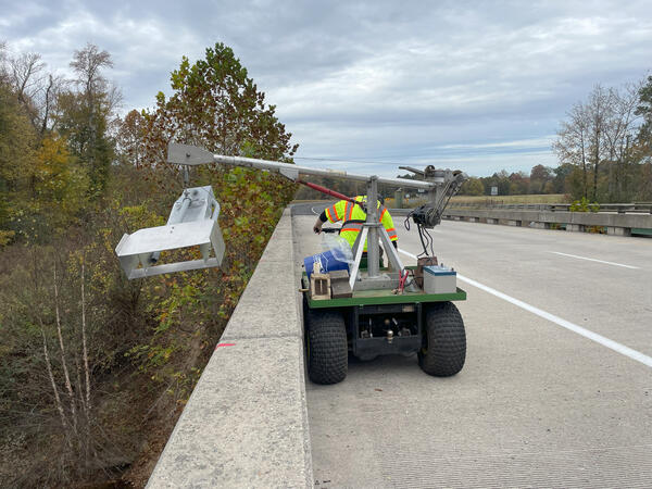
In order to measure which areas are losing sediment to erosion, and which areas are trapping sediment due to deposition, several geomorphic creek transects have been established.

Creek Transects
These transects have been established across different sections of Accotink Creek in order to measure erosion and deposition.
Pins made of rebar are driven into the floodplain and the banks at specific locations, and the initial length of the pin emerging is measured. As erosion occurs, more of the pin emerges over time, and the measured length of the pins increases. As deposition occurs, the pins become buried deeper, and the measured length decreases. In this way, scientists can measure where Accotink Creek might be trapping or losing sediment, and how much.
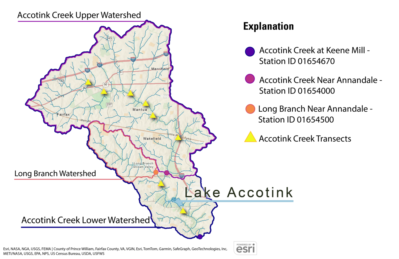
Monitoring Locations
This map shows the locations of the three USGS stream monitoring stations and the proposed locations of the geomorphic creek transects.
This study is a part of the Fairfax County Water Resources Monitoring Network.

Fairfax County Water Resources Monitoring Network


Photos


This work is being carried out on behalf of our partners at the Fairfax County Department of Public Works and Environmental Services.
Fairfax County Department of Public Works and Environmental Services

Learn more about the work done by our partners in Fairfax County.
DPWES Smaller Lake Accotink Preservation Feasibility Study Website

Check out Fairfax County's Smaller Lake Accotink Preservation Feasibility Study page for more information about other components of this study and find ways to get involved.
Lake Accotink is a 55-acre lake in Fairfax County which is highly valued by the local community. Much like a living organism, lakes go through many changes. Several factors affect their health and well-being such as sediment buildup. As the lake fills with sediment, it loses surface area and volume.
Lake Accotink has been dredged in the past to remove excess sediment, but this process is costly, disruptive to nearby communities, and can negatively affect the natural resources of the lake and surrounding area. The areas upstream were heavily developed prior to Virginia stormwater management regulations and have increased water flow in Accotink Creek, transporting significant sediment to the lake, making regular dredging to maintain its current size potentially unsustainable.
The lake is fed by Accotink Creek, including the Long Branch tributary. Long Branch delivers a disproportionately large amount of sediment relative to its size. The USGS is monitoring Lake Accotink, Accotink Creek, and Long Branch to better understand sediment flow into and out of the lake. This information will assist Fairfax County in preserving a smaller Lake Accotink for the foreseeable future.
Table of Contents
Introduction: The Issue of Sedimentation
Sedimentation is an issue affecting Lake Accotink. Sediments are eroded from various locations within the watershed and transported downstream by flowing water. Sources of sediment include streambanks, the streambed, floodplain soils, and upland soils. The largest movements of sediment in the watershed tend to occur during storms.
When the water carrying these sediments reaches the lake, the water slows down. This reduced speed allows some larger, heavier sediment to settle on the lakebed, while other smaller sediment particles may remain suspended and flow past the dam into the downstream portion of Accotink Creek.
As sediments accumulate in the lake, its surface area and volume decreases.
Goals of this Study
This study has two different aspects: understanding sediment behavior in both Lake Accotink and in Accotink Creek. The Lake Accotink Sedimentation Study is designed to examine sediment behavior in Lake Accotink, focusing on how quickly the lake fills with sediment. The Accotink Creek study examines sediment behavior in Accotink Creek, including the Long Branch tributary, and identifies sources of sediment in the creek.
To answer these questions, the USGS is doing the following:
Lake Accotink Sedimentation Study:
- Collect data needed to calculate annual loads of suspended sediment transported below Lake Accotink
- Collect data needed to calculate bedload above Lake Accotink
- Compute the annual total sediment load above Lake Accotink and suspended sediment load below Lake Accotink
- Develop a sediment mass-balance for Lake Accotink
Accotink Creek Study:
- Identify and measure sources and sinks of sediment in Accotink Creek
- Monitor changes in channel shape at multiple locations in Accotink Creek
- Develop a sediment budget for Accotink Creek
- Collect data needed to calculate annual loads of nitrogen, phosphorus, and major ions transported below Lake Accotink
- Calculate annual loads of nutrients and major ions below Lake Accotink
Title
Title
Webcams
Two of the three Accotink Project monitoring locations, Long Branch and Accotink Creek below Lake Accotink, are equipped with cameras that provide regular imagery of stream conditions.
Long Branch above the Lake
Accotink Creek below the Lake
Lake Accotink Study
Continuous monitoring of water quantity and quality, as well as discrete measurements of suspended sediment, is being conducted at the two main tributaries flowing into Lake Accotink and at a site downstream of the lake. The difference in the amount of sediment entering and exiting the lake serves as an indicator of sediment storage within the lake. By understanding the lake's volume and the rate of sediment accumulation, we can estimate how quickly the lake will fill up or require dredging.
Accotink Creek Study
Erosion can change the shape of a stream channel, usually by eroding its banks. Urban streams experiencing bank erosion often have concave banks, such as those seen in many areas of Accotink Creek.
Bank erosion is often a major source of sediment. As the banks erode, the sediment that once made up the banks is carried downstream. Some of this sediment might be deposited on floodplains, which prevents it from being carried downstream into Lake Accotink. Understanding which reaches of Accotink Creek are experiencing bank erosion and how much, as well as which floodplains are trapping sediment, is critical to understanding the role Accotink Creek plays in the overall story of sedimentation in this watershed.
In order to measure which areas are losing sediment to erosion, and which areas are trapping sediment due to deposition, several geomorphic creek transects have been established.
Creek Transects
These transects have been established across different sections of Accotink Creek in order to measure erosion and deposition.
Pins made of rebar are driven into the floodplain and the banks at specific locations, and the initial length of the pin emerging is measured. As erosion occurs, more of the pin emerges over time, and the measured length of the pins increases. As deposition occurs, the pins become buried deeper, and the measured length decreases. In this way, scientists can measure where Accotink Creek might be trapping or losing sediment, and how much.
Monitoring Locations
This map shows the locations of the three USGS stream monitoring stations and the proposed locations of the geomorphic creek transects.
This study is a part of the Fairfax County Water Resources Monitoring Network.
Fairfax County Water Resources Monitoring Network
Photos
This work is being carried out on behalf of our partners at the Fairfax County Department of Public Works and Environmental Services.
Fairfax County Department of Public Works and Environmental Services
Learn more about the work done by our partners in Fairfax County.
DPWES Smaller Lake Accotink Preservation Feasibility Study Website
Check out Fairfax County's Smaller Lake Accotink Preservation Feasibility Study page for more information about other components of this study and find ways to get involved.