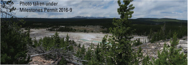
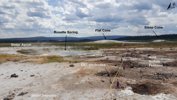
U.S. flag

An official website of the United States government

Images

Volcano Science Center images.

Filter Total Items: 551
Looking down into a barren valley with some hot springs. Trees in the foreground and background. Mountain in the far back.
Looking west over The Gap subbasin of Norris Geyser Basin, Yellowstone National Park

Looking west over The Gap subbasin of Norris Geyser Basin, Yellowstone National Park, from a vantage point on the Ragged Hills. The mountain in the distance is Mt. Holmes. Photo taken in June 2018 by Lauren Harrison. 

Time series of vertical displacements during April–October 2017 at four GPS stations on the north side of Yellowstone Lake

Time series of vertical displacements during April–October 2017 at four GPS stations (LAK1, LAK2, LKWY, and SEDG) on the north side of Yellowstone Lake. Downward trends indicate subsidence and upward trends show uplift. Uplift “spikes” in late September are related to inclement weather and do not show true deformation. Error bars are one standard deviation.

Time series of vertical displacements during April–October 2017 at four GPS stations (LAK1, LAK2, LKWY, and SEDG) on the north side of Yellowstone Lake. Downward trends indicate subsidence and upward trends show uplift. Uplift “spikes” in late September are related to inclement weather and do not show true deformation. Error bars are one standard deviation.

Deformation near South Sister from GPS data, 2001-2017

Horizontal displacements from campaign (black vectors) and continuous (red vectors, with station names given) GPS stations, as well as vertical displacements (indicated by color of GPS station symbol) near South Sister, Oregon. Length of arrow gives amount of horizontal displacement, with scale in lower left showing an arrow length

Horizontal displacements from campaign (black vectors) and continuous (red vectors, with station names given) GPS stations, as well as vertical displacements (indicated by color of GPS station symbol) near South Sister, Oregon. Length of arrow gives amount of horizontal displacement, with scale in lower left showing an arrow length

Roadcut exposure of Huckleberry Ridge Tuff and Mesa Falls Tuff along U.S. Route 20 between Ashton and Island Park, Idaho
Four scientists in safety vests in a grassy meadow with occasional bounders setting up geophysical equipment
Field crew setting up a magnetotelluric site in Yellowstone National Park

Field crew from Oregon State University and University of Wisconsin-Madison install a magnetotelluric site within Yellowstone National Park. 

The head of an immature wetsalts tiger beetle at the entrance to the burrow it dug
Head of an immature wetsalts tiger beetle at the entrance to the burrow it dug
Map showing volcanoes that formed at the leading edge of the Yellowstone hotspot in the past several million years

Map showing volcanoes that formed at the leading edge of the Yellowstone hotspot in the past several million years.  (A) Map of northwest Wyoming, eastern Idaho, and southern Montana (modified from Brueseke et al., 2017, https://doi.org/10.1130/GES01553.1).  Upper Wind River Basin (UWRB) is depicted by dashe

Grant Village boat dock, on the West Thumb of Yellowstone Lake, where a water-level sensor measures lake level
WorldView-2 satellite image showing thermal areas on the north side of Mallard Lake resurgent dome in Yellowstone National Park.
A blue glow is emitted by radiation during operation of the USGS TRIGA Reactor, Denver, CO

A blue glow is emitted by radiation during operation of the USGS TRIGA® Reactor, a low-power nuclear research reactor in Denver, Colorado. Photo by Christopher Farwell, October 27, 2017.

Plume of white water and steam emanating from a dark pool of water in a barren area, trees and blue sky in background
Echinus Geyser in eruption in 2017

Echinus Geyser in eruption on October 24, 2017.  Photo by MA Bellingham, used with permission.

Weir on a tributary flowing into Boundary Creek in southwest Yellowstone National Park

A weir constructed by Irving Friedman and Dan Norton to measure water discharge and to monitor changes in hydrothermal activity on a tributary flowing into Boundary Creek in southwest Yellowstone National Park. USGS photo by Shaul Hurwitz, September 17, 2017.

A weir constructed by Irving Friedman and Dan Norton to measure water discharge and to monitor changes in hydrothermal activity on a tributary flowing into Boundary Creek in southwest Yellowstone National Park. USGS photo by Shaul Hurwitz, September 17, 2017.

Focal mechanism determined by moment tensor analysis on an M4.4 event in Yellowstone National Park in 2017

Focal mechanism determined by moment tensor analysis, which uses a model to fit the long-period (~10 s period or greater) ground motion records recorded at multiple locations.

Newly emerged adult wetsalts tiger beetle

A newly emerged adult wetsalts tiger beetle. Photo by Robert K. D. Peterson, 2017.

Panoramic photo of the West Yellowstone rhyolite lava flow

Panoramic of the West Yellowstone rhyolite lava flow taken along Highway 20 (between the West entrance of Yellowstone National Park and Madison Junction). The flow is approximately 111,000 years old and has a volume of about 41 km3 (10 mi3). 

Panoramic of the West Yellowstone rhyolite lava flow taken along Highway 20 (between the West entrance of Yellowstone National Park and Madison Junction). The flow is approximately 111,000 years old and has a volume of about 41 km3 (10 mi3). 

A geologist examples a basaltic lava flow along the Madison River

A geologist examples a basaltic lava flow along the Madison River, looking for an area that can yield samples suitable for 40Ar/39Ar geochronology.  USGS photo by Jorge Vazquez, June 2017.

Barren and rocky mountainsides at sunset with some clouds in the distance
Jim McClure-Jerry Peak Wilderness area in central Idaho

The geology of the Jim McClure-Jerry Peak Wilderness area in central Idaho includes the Challis volcanics, which erupted about 52–45 million years ago.  Photo by Matt Liedecker, Bureau of Land Management, May 23, 2017 (https://www.flickr.com/photos/blmidaho/34808808006/).

The geology of the Jim McClure-Jerry Peak Wilderness area in central Idaho includes the Challis volcanics, which erupted about 52–45 million years ago.  Photo by Matt Liedecker, Bureau of Land Management, May 23, 2017 (https://www.flickr.com/photos/blmidaho/34808808006/).

Snowplow removing snow form a road, with trees in the background under partly cloudy skies
Plowing operations in Yellowstone National Park

Plowing operations in Yellowstone National Park.  Photo by Jake Frank, March 28, 2017.

Allan Lerner
Allan Lerner
Allan Lerner
Allan Lerner

Allan Lerner works in the USGS volcanic gas geochemistry group. The photo was taken in the crater of Mount St. Helens, with Spirit Lake and Mount Rainier in the distance. USGS photo by P. Kelly.

Allan Lerner works in the USGS volcanic gas geochemistry group. The photo was taken in the crater of Mount St. Helens, with Spirit Lake and Mount Rainier in the distance. USGS photo by P. Kelly.

Helicopter carrying geophysical sensors above Yellowstone National Park

Helicopter with airborne electromagnetics sensors dangling beneath as it flies over a portion of Yellowstone National Park.  Photo by Jeff Hungerford, November 2016.

Was this page helpful?