
Drought preparedness in Mt. Rainier National Park
Small streams are an important source of water in Mount Rainier National Park. Some streams run year-round, while others go dry during the late summer. The USGS used crowd-sourced data to develop a localized model of Mount Rainier streams. The model provides predictions of whether streams are likely to flow year-round, helping park managers plan for a sustainable water supply.
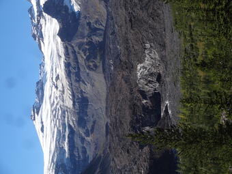
Small streams are an important source of water in Mount Rainier National Park (Park). Streams supply water to park facilities such as visitor centers and campgrounds, and backcountry users drink from these streams as well. Additionally, the presence or absence of water in streams influences where fish, water-dwelling insects, and amphibians can live. The USGS researched when and where streams are likely to go dry in and around Mount Rainier.
USGS and Park staff, and volunteers collected hundreds of observations of whether streams were dry or flowing during the late summer. We updated an existing streamflow permanence model with locally important variables like geology and climate to predict flowing or dry conditions.
The resulting maps and database aid the Park in planning a sustainable water supply and protecting sensitive species. Only 37 percent of the streams modeled were estimated to flow during the late summer. Mapping these streams reveals areas that may have limited water supply, especially during years with lower snowpack.
The modeling endeavor also improves our scientific understanding of mountain streams. Streams flowing from glaciers had a higher probability of flowing through the summer. These results demonstrate that factors such as geology, geomorphology, and climate can influence year-round water supply.
View more results from our factsheet
Read the full published study
Learn more about streamflow permanence research in the Pacific Northwest
Other USGS streamflow permanence research may be found at the links below.

Streamflow Permanence in the Pacific Northwest

Water temperature modeling in Mount Rainier National Park

Updated classifications of flow permanence on streams in the Colville National Forest
Small streams are an important source of water in Mount Rainier National Park. Some streams run year-round, while others go dry during the late summer. The USGS used crowd-sourced data to develop a localized model of Mount Rainier streams. The model provides predictions of whether streams are likely to flow year-round, helping park managers plan for a sustainable water supply.
Small streams are an important source of water in Mount Rainier National Park (Park). Streams supply water to park facilities such as visitor centers and campgrounds, and backcountry users drink from these streams as well. Additionally, the presence or absence of water in streams influences where fish, water-dwelling insects, and amphibians can live. The USGS researched when and where streams are likely to go dry in and around Mount Rainier.
USGS and Park staff, and volunteers collected hundreds of observations of whether streams were dry or flowing during the late summer. We updated an existing streamflow permanence model with locally important variables like geology and climate to predict flowing or dry conditions.
The resulting maps and database aid the Park in planning a sustainable water supply and protecting sensitive species. Only 37 percent of the streams modeled were estimated to flow during the late summer. Mapping these streams reveals areas that may have limited water supply, especially during years with lower snowpack.
The modeling endeavor also improves our scientific understanding of mountain streams. Streams flowing from glaciers had a higher probability of flowing through the summer. These results demonstrate that factors such as geology, geomorphology, and climate can influence year-round water supply.
View more results from our factsheet
Read the full published study
Learn more about streamflow permanence research in the Pacific Northwest
Other USGS streamflow permanence research may be found at the links below.
Streamflow Permanence in the Pacific Northwest
Water temperature modeling in Mount Rainier National Park