
Kristin L Jaeger
As a research hydrologist and geomorphologist, my previous research has generally followed two trajectories: 1) geomorphic response to disturbance including dam removal, surface coal mining, and invasive species and 2) characterizing patterns and controls on flow permanence of intermittent and ephemeral rivers and streams.
My current focus includes broadening flow permanence research to the Pacific Northwest region and evaluating changes in sediment and stream water temperature regimes and associated implications on river ecosystem health in Pacific Northwest mountain rivers
Science and Products
USFS: Western Oregon Streamflow Permanence
USFS: Western Oregon Streamflow Permanence
USFS: Western Oregon WeT DRy model (WOWTDR)
USFS: Western Oregon WeT DRy model (WOWTDR)
Filter Total Items: 15
PROSPER Puget Sound - Modeling Streamflow Permanence
The Issue: Knowing when streams have water and when they run dry—called streamflow permanence—is necessary for managing water resources, protecting ecosystems, and responding to regulations and policies. In the Pacific Northwest, a major research priority is understanding how streamflow permanence might change as snowpacks shrink and summers become hotter and drier. How USGS will help: USGS is...

Streamflow Permanence in the Pacific Northwest
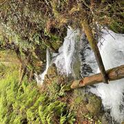
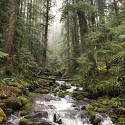
Not all rivers and streams flow year-round. Understanding when and where streams flow or go dry is critical for managing land use, water quality, and water availability on landscapes. The USGS and partners are studying streamflow permanence in the Pacific Northwest. We are gathering data, developing new models, and providing data visualization and outreach tools.

Integration of Urban Stormwater Infrastructure in Modeling Water Quality Patterns in Small Urban Streams
The Issue: Stormwater can quickly run off impervious surfaces delivering potentially polluted water to streams and rivers in the Puget Sound region. Runoff from impervious surfaces can either be directly connected to streams through stormwater pipes or indirectly connected if runoff is routed to some other surface such as grass or a feature like a stormwater management structure. It is currently...

Water temperature modeling in Mount Rainier National Park
The Issue: Changes in the water temperature and flow regimes of rivers throughout the western United States have contributed to shifts in the ranges of aquatic species that they support. Cold-water species such as fish are sensitive to changes in water temperature, which regulates their physiological functions and behavior. How USGS will help: A spatial stream network (SSN) model was developed...
Analysis and synthesis of headwater streamflow modeling and downstream effects
There is a critical need for improved headwater stream modeling as headwaters are vulnerable to loss, destruction, or hydrologic alterations.

Updated classifications of flow permanence on streams in the Colville National Forest
The Issue: Streamflow permanence refers to the probability that a stream will lose surface flow (become a dry channel), as well as the timing, duration, and frequency of drying. Patterns of streamflow permanence drive important decisions regarding forest management and other land uses. The Colville National Forest Land and Resource Management Plan (2019), for example, specifies riparian management...

State of the Science in Streamflow Modeling in the North Central Region to Address Partner Needs for Water Availability Under Drought Conditions
Land and water managers often rely on hydrological models to make informed management decisions. Understanding water availability in streams, rivers, and reservoirs during high demand periods that coincide with seasonal low flows can affect how water managers plan for its distribution for human consumption while sustaining aquatic ecosystems. Substantial advancement in hydrological...
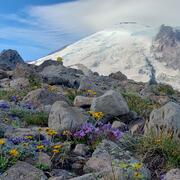
Drought preparedness in Mt. Rainier National Park
Small streams are an important source of water in Mount Rainier National Park. Some streams run year-round, while others go dry during the late summer. The USGS used crowd-sourced data to develop a localized model of Mount Rainier streams. The model provides predictions of whether streams are likely to flow year-round, helping park managers plan for a sustainable water supply.

Development of a Streamflow Data Catalog and Evaluation of the Vulnerability of Sensitive Fish Species to Climate Change Across the Pacific Northwest
As freshwater streams and native fish are threatened by changing environmental conditions, efforts to coalesce existing data and integrate modeling and projection tools are increasingly necessary for informing effective land, water, and species management. For example, identifying and integrating disparate datasets of streamflow, stream water temperature and species distribution is...

Quantifying suspended-sediment load and transport characteristics in the Calawah and Upper Bogachiel Rivers, Washington
The issue: Salmonid fisheries are an important cultural and economic activity and efforts to support a thriving fisheries industry remain a major priority for the Quileute Tribe on the Olympic Peninsula, Washington. Land use changes can have a profound influence on basin sediment production with direct effects on fisheries (Madej and Ozaki, 2009). Studies are needed to improve estimates of the...

Coarse sediment delivery and routing in the White River
The Issue: Ongoing channel aggradation has reduced flow conveyance along the lower White River, increasing the flood risk in urban-suburban areas. A refined understanding of the delivery, transport and deposition of sediment in the White River, and how those processes may be influenced by climate and existing dam operations, is necessary in order to plan for future flood hazard in the lower White...

Fine sediment infiltration in Chinook spawning gravels in the Sauk River Basin, Washington
The Issue: There is concern that inherently high finer-grained (small gravel, sand, and silt) sediment loads in the Sauk River system may adversely affect egg-to-fry survival of ESA-listed Chinook salmon in the Sauk River and lower Skagit River Basin. However, there are no quantitative data for the Sauk River basin to assess if fine sediment deposition and infiltration into spawning gravels are at...
Science and Products
USFS: Western Oregon Streamflow Permanence
USFS: Western Oregon Streamflow Permanence
USFS: Western Oregon WeT DRy model (WOWTDR)
USFS: Western Oregon WeT DRy model (WOWTDR)
Filter Total Items: 15
PROSPER Puget Sound - Modeling Streamflow Permanence
The Issue: Knowing when streams have water and when they run dry—called streamflow permanence—is necessary for managing water resources, protecting ecosystems, and responding to regulations and policies. In the Pacific Northwest, a major research priority is understanding how streamflow permanence might change as snowpacks shrink and summers become hotter and drier. How USGS will help: USGS is...
Streamflow Permanence in the Pacific Northwest
Not all rivers and streams flow year-round. Understanding when and where streams flow or go dry is critical for managing land use, water quality, and water availability on landscapes. The USGS and partners are studying streamflow permanence in the Pacific Northwest. We are gathering data, developing new models, and providing data visualization and outreach tools.
Integration of Urban Stormwater Infrastructure in Modeling Water Quality Patterns in Small Urban Streams
The Issue: Stormwater can quickly run off impervious surfaces delivering potentially polluted water to streams and rivers in the Puget Sound region. Runoff from impervious surfaces can either be directly connected to streams through stormwater pipes or indirectly connected if runoff is routed to some other surface such as grass or a feature like a stormwater management structure. It is currently...
Water temperature modeling in Mount Rainier National Park
The Issue: Changes in the water temperature and flow regimes of rivers throughout the western United States have contributed to shifts in the ranges of aquatic species that they support. Cold-water species such as fish are sensitive to changes in water temperature, which regulates their physiological functions and behavior. How USGS will help: A spatial stream network (SSN) model was developed...
Analysis and synthesis of headwater streamflow modeling and downstream effects
There is a critical need for improved headwater stream modeling as headwaters are vulnerable to loss, destruction, or hydrologic alterations.
Updated classifications of flow permanence on streams in the Colville National Forest
The Issue: Streamflow permanence refers to the probability that a stream will lose surface flow (become a dry channel), as well as the timing, duration, and frequency of drying. Patterns of streamflow permanence drive important decisions regarding forest management and other land uses. The Colville National Forest Land and Resource Management Plan (2019), for example, specifies riparian management...
State of the Science in Streamflow Modeling in the North Central Region to Address Partner Needs for Water Availability Under Drought Conditions
Land and water managers often rely on hydrological models to make informed management decisions. Understanding water availability in streams, rivers, and reservoirs during high demand periods that coincide with seasonal low flows can affect how water managers plan for its distribution for human consumption while sustaining aquatic ecosystems. Substantial advancement in hydrological...
Drought preparedness in Mt. Rainier National Park
Small streams are an important source of water in Mount Rainier National Park. Some streams run year-round, while others go dry during the late summer. The USGS used crowd-sourced data to develop a localized model of Mount Rainier streams. The model provides predictions of whether streams are likely to flow year-round, helping park managers plan for a sustainable water supply.
Development of a Streamflow Data Catalog and Evaluation of the Vulnerability of Sensitive Fish Species to Climate Change Across the Pacific Northwest
As freshwater streams and native fish are threatened by changing environmental conditions, efforts to coalesce existing data and integrate modeling and projection tools are increasingly necessary for informing effective land, water, and species management. For example, identifying and integrating disparate datasets of streamflow, stream water temperature and species distribution is...
Quantifying suspended-sediment load and transport characteristics in the Calawah and Upper Bogachiel Rivers, Washington
The issue: Salmonid fisheries are an important cultural and economic activity and efforts to support a thriving fisheries industry remain a major priority for the Quileute Tribe on the Olympic Peninsula, Washington. Land use changes can have a profound influence on basin sediment production with direct effects on fisheries (Madej and Ozaki, 2009). Studies are needed to improve estimates of the...
Coarse sediment delivery and routing in the White River
The Issue: Ongoing channel aggradation has reduced flow conveyance along the lower White River, increasing the flood risk in urban-suburban areas. A refined understanding of the delivery, transport and deposition of sediment in the White River, and how those processes may be influenced by climate and existing dam operations, is necessary in order to plan for future flood hazard in the lower White...
Fine sediment infiltration in Chinook spawning gravels in the Sauk River Basin, Washington
The Issue: There is concern that inherently high finer-grained (small gravel, sand, and silt) sediment loads in the Sauk River system may adversely affect egg-to-fry survival of ESA-listed Chinook salmon in the Sauk River and lower Skagit River Basin. However, there are no quantitative data for the Sauk River basin to assess if fine sediment deposition and infiltration into spawning gravels are at...