
Welcome to the Washington Water Science Center
Washington Water Science Center
The USGS Washington Water Science Center provides water resource information. You’ll find information about Washington’s rivers and streams, as well as groundwater, water quality, and cutting-edge water research. We welcome you to explore our data and scientific research.
Current Washington Water Conditions
Current Washington Water Conditions

Explore real-time Washington streamflow, groundwater, and water-quality conditions and access data with our new interactive map application.
View current water conditions
View current water conditions
Uncrewed Aviation Systems Program
Uncrewed Aviation Systems Program

Data collection provided by uncrewed aviation systems (UAS) enhances the Washington Water Science Center’s (WAWSC) ability to monitor dynamic environmental systems, respond to natural hazards, analyze the impacts of climate change, and assess landscape change.
News
Sediment contaminants in Puget Sound: Implications for ecosystem health and remediation
Sediment contaminants in Puget Sound: Implications for ecosystem health and remediation
Washington Waters Newsletter - Spring 2025
Washington Waters Newsletter - Spring 2025
New data products now available in StreamStats
New data products now available in StreamStats
Publications
Historical ice jams and associated environmental conditions on Osoyoos Lake Historical ice jams and associated environmental conditions on Osoyoos Lake
Ice jams occur regularly at the southern outlet of Osoyoos Lake, which spans the border between the State of Washington and British Columbia, Canada. In recent winters, ice jams caused (1) decreases in downstream discharge that may adversely affect salmon spawning habitat and (2) short-duration lake-level rise that can interfere with lake level management agreements. In response, water...
Estimation of impounded sediment volume in the Similkameen River upstream of Enloe Dam, Okanogan County, Washington Estimation of impounded sediment volume in the Similkameen River upstream of Enloe Dam, Okanogan County, Washington
The Enloe Dam was built in 1920 for hydropower generation and impounds a steep-banked, narrow reach of the Similkameen River in north-central Washington. During the subsequent century, sediment from the Similkameen River watershed, which includes historical mining operations, accumulated within Enloe Dam’s impoundment. Enloe Dam ceased hydropower production in 1958 and is currently under
Lost in translation: Reconciling different streamflow permanence data products Lost in translation: Reconciling different streamflow permanence data products
The objective of this study is to provide a framework to reconcile streamflow permanence products that provide information on whether a stream is perennial or nonperennial. Accurate classification of streams as perennial or nonperennial is important for a variety of land and water resource management decisions. However, resource managers are challenged with how to reconcile different...
Science
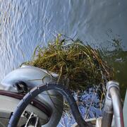
Water Stargrass in the Lower Yakima River
The lower Yakima River faces water resource management challenges resulting from abundant water plant growth, negatively impacting water quality. New U.S. Geological Survey (USGS) research provides a deeper understanding of river conditions, informing resource management to protect this river and the communities it supports.
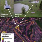
Remotely mapping stormwater facility footprints and storage volumes
Stormwater management practices are being used throughout the Chesapeake Bay watershed to reduce flood risks and pollutant loads, but consistent and comprehensive maps of these practices are often lacking. Stormwater managers often have incomplete information about the location and storage volume of stormwater facilities within their jurisdiction. Therefore, the USGS is working to develop...
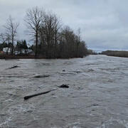
Testing non-contact discharge measurement methods in the Nooksack River
The Issue: The North Cedarville streamgage on the Nooksack River (USGS 12210700) is critical for flood monitoring and hazard assessments. However, making discharge measurements at high flows, which are necessary to maintain an accurate stage-discharge relation at this dynamic site, is complicated by transport of woody debris and difficulties detecting the bed using traditional acoustic doppler...