Biological soil crusts (biocrusts, photoautotrophic soil surface communities comprised of cyanobacteria, algae, bryophytes, lichens, and fungi) occur in drylands globally where they contribute to ecosystem functioning by increasing soil stability, reducing dust emissions, and modifying soil resource availability (e.g., water, nutrients) (Fig 1.3.1). Despite increasing recognition and interest in the global extent and functional importance of biocrusts, determining the spatial extent and condition of biocrusts across landscapes continues to present considerable challenges to scientists and land managers making it difficult to quantify biocrust contributions to ecosystem functioning at larger spatial scales. However, given that biocrust biomass and biological activity is typically concentrated and visible in the uppermost millimeters of the soil surface, remote sensing offers promising opportunities to detect and characterize biocrust communities, differentiate among biocrust community types, and monitor changes in biocrust distribution across dryland landscapes globally.
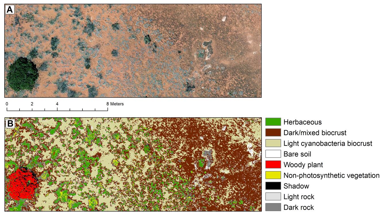
Biocrusts grow in patches, cover vast expanses of rugged terrain, and are vulnerable to physical disturbance associated with ground-based mapping techniques. Therefore, small Unmanned Aerial Systems (UAS) provide an ideal platform to provide detailed mapping of these fragile communities (Figure 1.3.2.). For this project we are using low-cost UASs to collect high-resolution (less than 1-cm) images to map biocrust, soils and vegetation cover. We established 80 plots across 10 field sites south of Canyonlands National Park in southeastern Utah, and measured cover and composition of biocrusts (and herbaceous plants (Figure 1.3.3). that were used to train and validate UAS image classifications (Figure 1.3.4). Results from this study will aid scientists and land managers in mapping and monitoring biocrust condition and extent across drylands, which may increase our ability to monitor biocrust function by linking biocrust contributions to ecosystem processes at larger spatial scales, and set future targets for dryland conservation and restoration.
Future work: Field monitoring plots and UAS imagery will be used to scale up biocrust information over the larger landscape using high resolution WorldView-3 satellite data (31-cm panchromatic resolution, 1.24-m multispectral, and 3.7-m shortwave infrared), and moderate-resolution Sentinel and Landsat satellites.


Below are related data releases.
UAS products and field data for biocrust soil heterogeneity research, Beef Basin, Utah UAS products and field data for biocrust soil heterogeneity research, Beef Basin, Utah
Below are publications associated with this project.
Soil cover heterogeneity associated with biocrusts predicts patch-level plant diversity patterns Soil cover heterogeneity associated with biocrusts predicts patch-level plant diversity patterns
Hyperspectral imaging predicts differences in carbon and nitrogen status among representative biocrust functional groups of the Colorado Plateau Hyperspectral imaging predicts differences in carbon and nitrogen status among representative biocrust functional groups of the Colorado Plateau
Ultra‐high‐resolution mapping of biocrusts with Unmanned Aerial Systems Ultra‐high‐resolution mapping of biocrusts with Unmanned Aerial Systems
Below are partners associated with this project.
Biological soil crusts (biocrusts, photoautotrophic soil surface communities comprised of cyanobacteria, algae, bryophytes, lichens, and fungi) occur in drylands globally where they contribute to ecosystem functioning by increasing soil stability, reducing dust emissions, and modifying soil resource availability (e.g., water, nutrients) (Fig 1.3.1). Despite increasing recognition and interest in the global extent and functional importance of biocrusts, determining the spatial extent and condition of biocrusts across landscapes continues to present considerable challenges to scientists and land managers making it difficult to quantify biocrust contributions to ecosystem functioning at larger spatial scales. However, given that biocrust biomass and biological activity is typically concentrated and visible in the uppermost millimeters of the soil surface, remote sensing offers promising opportunities to detect and characterize biocrust communities, differentiate among biocrust community types, and monitor changes in biocrust distribution across dryland landscapes globally.
Biocrusts grow in patches, cover vast expanses of rugged terrain, and are vulnerable to physical disturbance associated with ground-based mapping techniques. Therefore, small Unmanned Aerial Systems (UAS) provide an ideal platform to provide detailed mapping of these fragile communities (Figure 1.3.2.). For this project we are using low-cost UASs to collect high-resolution (less than 1-cm) images to map biocrust, soils and vegetation cover. We established 80 plots across 10 field sites south of Canyonlands National Park in southeastern Utah, and measured cover and composition of biocrusts (and herbaceous plants (Figure 1.3.3). that were used to train and validate UAS image classifications (Figure 1.3.4). Results from this study will aid scientists and land managers in mapping and monitoring biocrust condition and extent across drylands, which may increase our ability to monitor biocrust function by linking biocrust contributions to ecosystem processes at larger spatial scales, and set future targets for dryland conservation and restoration.
Future work: Field monitoring plots and UAS imagery will be used to scale up biocrust information over the larger landscape using high resolution WorldView-3 satellite data (31-cm panchromatic resolution, 1.24-m multispectral, and 3.7-m shortwave infrared), and moderate-resolution Sentinel and Landsat satellites.


Below are related data releases.
UAS products and field data for biocrust soil heterogeneity research, Beef Basin, Utah UAS products and field data for biocrust soil heterogeneity research, Beef Basin, Utah
Below are publications associated with this project.
Soil cover heterogeneity associated with biocrusts predicts patch-level plant diversity patterns Soil cover heterogeneity associated with biocrusts predicts patch-level plant diversity patterns
Hyperspectral imaging predicts differences in carbon and nitrogen status among representative biocrust functional groups of the Colorado Plateau Hyperspectral imaging predicts differences in carbon and nitrogen status among representative biocrust functional groups of the Colorado Plateau
Ultra‐high‐resolution mapping of biocrusts with Unmanned Aerial Systems Ultra‐high‐resolution mapping of biocrusts with Unmanned Aerial Systems
Below are partners associated with this project.

