
Monitoring and Detection
Monitoring and Detection
Filter Total Items: 72
Western U.S. Using Networked Weather Radar and Wildlife Tracking Data
USGS scientists from the Wetland and Aquatic Research Center and the Western Ecological Research Center are collaborating to synthesize data on migratory bird use of Bureau of Land Management lands in the western U.S. to support permitting decisions.
Evaluating Efficacy of Stewardship Actions for Vulnerable Gulf of America Coastal Birds Through Co-Production Between Scientists and Resource Managers
The USGS and partners will survey bird and human activity on beaches in Alabama, Mississippi, and Louisiana to determine breeding bird response to stewardship activities aimed at protecting and recovering bird populations.
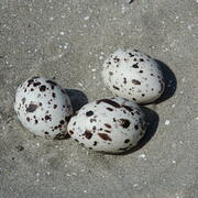
Winter Shorebird Surveys of Federally Protected Bird Species Following Restoration at West Belle Headland and Trinity-East Island, Louisiana
The USGS and the Barataria-Terrebonne National Estuary Program (BTNEP) conducted post-restoration monitoring of Piping Plovers and Red Knots to better understand how birds respond to coastal restoration.

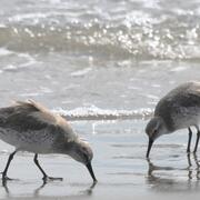
Tracking Non-breeding Habitat Use by Dunlin, Pectoral Sandpipers, and Other Migratory Shorebirds in the Mississippi Delta
USGS researchers and heir partners are capturing and banding birds that use man-made habitats to gather data on species occurrence, abundance, and energetic condition during autumn migration.

Biological Vulnerability to Hypoxia Under a Warmer Climate in the Northern Gulf
USGS researchers are a developing a modeling framework to assess climate warming impacts on hypoxia-related stress to commercially and recreationally important Gulf species.

Alabama Barrier Island Restoration Assessment at Dauphin Island
Dauphin Island, Alabama, is the only barrier island providing protection to much of Alabama's coastal natural resources. Severely impacted by repeated extreme events, like Hurricane Katrina and Deepwater Horizon oil spill, USGS and partners are conducting a joint study to evaluate the feasibility of certain alternatives to increase resiliency and sustainability of the island.

Natural Resource Damage and Assessment (NRDA) Program Monitoring and Adaptive Management
State and Federal agencies, including USGS, are working together to assess the damage caused by the Deepwater Horizon oil spill and to determine appropriate restoration actions to restore natural resources, ecological services, and recreational services injured or lost due to the incident.

A Fresh Set of Tools: New Information for Managing Fisheries During Changes in River Discharge
USGS scientists are conducting research to understand how estuary fisheries are affected by the the timing and/or magnitude of freshwater discharge into Lake Pontchartrain in Louisiana.

Avifauna Surveys of the Northern Main Chandeleur Islands
USGS WARC ecologists are assisting partners in conducting avian surveys on Chandeleur Islands during the pre-restoration monitoring phase to document threatened and endangered species, species richness and diversity, species abundance, and habitat use.

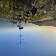
Use of Portable Radar to Monitor Flying Animals in the Offshore Environment
USGS will deploy a small, portable radar aboard a National Oceanic and Atmospheric Administration research vessel to measure the abundance, geographic distribution, and flight altitude of birds migrating across the continental shelf of the northern Gulf.

Vertical Control of Rod Surface Elevation Table (RSET) Benchmarks to Assess Implications of Sea-Level Rise within Texas Coastal Refuges
The USGS will establish Rod Surface Elevation Tables at five National Wildlife Refuges on the Texas coast. This work will support climate adaptation and resilience planning by identifying areas susceptible to loss and degradation due to sea-level rise and extreme climatic events along the Texas Gulf Coast.

Ecology of the Diamondback Terrapin: Demographics, Movements, and Habitat Use
In response to declining populations, researchers at WARC are collecting data on demographics, movement patterns and habitat use, ecological niche and foraging ecology, and nesting ecology of diamondback terrapins.