
The USGS Wetland and Aquatic Research Center provides unbiased, actionable, and timely scientific information, expertise, and tools to support the management and restoration of natural resources on, in, and around the Gulf of America.
The Gulf of America is a major economic region for the U.S. supporting fisheries, tourism, and oil and gas activities, both onshore and offshore. The 2024 Marine Economy report from NOAA noted that the Gulf supported more than 25,000 businesses and contributed employment to more than 584,000 people, based on data from 2021. It also contributed \$133 billion gross domestic product (GDP), ranking it the greatest contributor to GDP of all 8 coastal regions. The value of the Gulf's GDP has increased 44% in the last decade and the region's offshore mineral resources provide 72% of the GDP.
The USGS Wetland and Aquatic Research Center's science directly benefits the health, safety, and economy of the Gulf region by providing trusted and timely information and innovative decision support tools to help guide restoration activities, manage fish and wildlife, address water quality concerns such as harmful algal blooms and chemical pollutants, prevent the spread of costly invasive species, and support local communities in hurricane response and recovery efforts.
Restoration
USGS researchers work with the Gulf States to guide restoration activities to ensure the wetlands, barrier islands, and other coastal habitats are healthy and sustainable, so they are able to protect the coastal communities and infrastructure from hurricanes and storm-related flooding. USGS science also helps ensure that restoration efforts are cost-efficient and effective, protecting the region’s natural resources to ensure continued contributions to the marine economy and natural heritage.
Wetlands
Coastal wetlands have immense economic value; almost all the fish and shellfish caught by the fishing industry depend on estuaries and wetlands at some point in their life cycle, and the money brought in annually by the fishing industry to the Gulf Region reaches hundreds of millions of dollars. Loss of healthy coastal wetland habitats can have severe impacts not only on fish populations, but on the fishing industry and the regional economy as well. Coastal wetlands also incur economic value from their recreational use (e.g., fishing, kayaking, hiking, birdwatching), provisioning of raw materials (e.g., food, fiber, wood), and protection (e.g., prevent erosion, protect infrastructure, filter pollution from water, reduce flooding and storm surge).
Monitoring Coastal Restoration
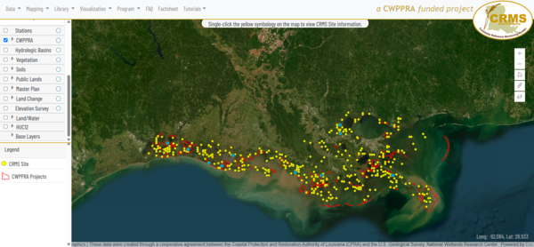
In Louisiana, which has experienced the greatest wetland loss of any other state in the continental U.S., USGS WARC and the State jointly lead the implementation of the Coastwide Reference Monitoring System (CRMS), which is considered the world’s largest coastal monitoring program with publicly available data. The long-term monitoring program collects data that is essential to Louisiana restoration efforts, and is used by landowners, researchers, and State and Federal agencies to plan, implement, and evaluate large-scale restoration across the Louisiana coast. Additionally, CRMS hydrology data are regularly used by the public to inform fishing and hunting conditions and have been cited by local media during flood and storm events.
Natural Resource Damage and Assessment Program
Pursuant to the Oil Pollution Act of 1990 (OPA) statutes and regulations and consistent with the Consent Decree for the Deepwater Horizon oil spill, State and Federal agencies, including USGS, are working together to restore natural resources and services injured or lost as a result of the spill. Trustees collectively determine and implement appropriate restoration actions to restore natural resources, ecological services, and recreational services. WARC science has contributed to the assessment and recovery of a variety of Gulf habitats, including deep sea sediments, nearshore, and wetland habitats; and wildlife such as fish, terrestrial and marine mammals, sea turtles, shellfish, corals, and birds.
Mapping Land Area Change in Louisiana
Louisiana has lost more than a quarter of its coastal wetlands, an area about the size of Delaware, since the 1930s. Changes to the Mississippi River and its ability to carry sediment downstream to the Gulf, coupled with sea-level rise, hurricanes, and land subsidence have contributed to the disappearance of these important ecosystems. USGS WARC scientists use historical surveys and aerial and satellite data to monitor the occurrence and rates of wetland change. By quantifying land area change over time, USGS WARC researchers are able to document and assess the short- and long-term effects of natural and anthropogenic factors on coastal wetland loss, information that natural resource managers can use to identify the areas in greatest need of restoration.

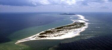
Barrier Islands
Barrier islands are dynamic environments at the land-sea interface that protect coastal communities from storm surge and coastal erosion, provide habitat for fish and wildlife, and offer opportunities for recreation and tourism. Storms, wave energy, currents, and wind are powerful forces that shape barrier islands, and with changing environmental conditions, including increased frequency and strength of hurricanes, natural resources managers and the Gulf States are concerned with the loss of barrier islands and the services they provide.
Alabama Barrier Island Restoration Assessment
The USGS, State of Alabama, and the U.S. Army Corps of Engineers conducted a joint study to evaluate the feasibility and cost of restoration alternatives to increase resiliency and sustainability of Dauphin Island, a barrier island that provides protection to much of the State of Alabama’s coastal natural resources, including one-third of the Mississippi Sound and estuarine habitats, such as oyster reefs, marshes, and seagrasses. Project findings were used to make decisions regarding which actions to take and what restoration alternatives to employ.
Mississippi Coastal Improvements Program
In Mississippi, USGS WARC is working with U.S. Army Corps of Engineers and other Federal and State agencies in developing and implementing a long-term monitoring and adaptive management program to be integrated into the Mississippi Coastal Improvements Program (MsCIP) barrier island restoration project. Mississippi's barrier islands are dynamic coastal landforms, experiencing changes in structure (land area and habitat) and geomorphic processes (erosion and accretion) due to frequent intense storms, relative rise in sea level, and changes in sediment supply. Long-term loss of the barrier islands threatens the highly productive Mississippi Sound estuarine ecosystem and exposes mainland Mississippi coast and its associated habitats to increasing saltwater intrusion and damage from future tropical storms. The MsCIP Comprehensive Plan includes the restoration of barrier islands, wetland and coastal forest habitat, among other projects to reduce future storm damage along the Mississippi Gulf Coast.
Louisiana's Barrier Island Comprehensive Monitoring
In Louisiana, USGS scientists have partnered with the Louisiana Coastal Protection Authority (CPRA) to help implement the Barrier Island Comprehensive Monitoring (BICM) program, which aims to provide long-term data that can be used to plan, design, evaluate, and maintain current and future barrier island restoration projects. One aspect of this program was the creation of habitat maps to provide a snapshot of coastal habitats to be combined with historical or future maps to monitor change over time. USGS WARC developed habitat classification schemes to monitor barrier island habitats and developed a web-based reporting tool to help natural resource managers visualize the habitat maps and habitat change maps.
Hurricanes and Storms
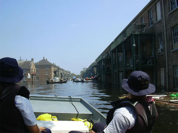
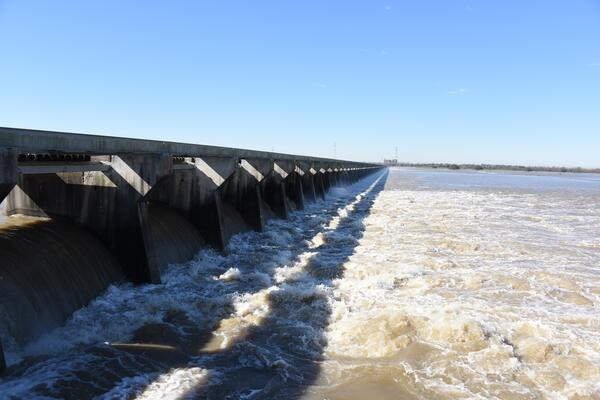
Coastal communities of the U.S. are home to 129 million people, or almost 40% of the nation's total population, and contribute \$10 trillion in goods and services annually. Hurricanes and intensifying storms are increasing coastal flooding, which inundates low-lying buildings, roads, and other infrastructure, destroying property and in some cases leading to the loss of life. Coastal wetlands provide key habitat to support commercial and recreational fisheries, and mitigate flooding and absorb wave energy, which can decrease property damage by up to 20%, providing \$23 billion annually in coastal protection services around the U.S.
Coastal wetlands are important ecosystems along the Gulf Coast that provide essential services such as reducing hurricane-induced floods and conserving biodiversity. However, these wetlands face potential loss and degradation due to rising sea levels, changing climate patterns, and ongoing coastal development. While wetland management and flood control agencies are developing long-term climate adaptation strategies, they require forward-looking knowledge and data about how wetlands along the Gulf Coast will evolve in the coming decades, and how they can better provide flood and storm surge protection during hurricanes.
Working closely with nine expert groups familiar with local and regional wetland management and flood control, USGS WARC scientists and partners are co-designing research and creating practical data to enhance wetland restoration and flood protection under environmental change. The researchers use remote sensing data and models to create maps depicting the current extent of coastal wetlands and how the coastal landscape might change with future conditions, coastal development, and restoration efforts. They can predict how hurricanes and the associated extreme precipitation and floods could change in the future. The project is also evaluating how effective existing wetland restoration projects are in reducing hurricane flood risks.

Fisheries and Wildlife
The Gulf is home to a diversity of fish and wildlife species, including waterfowl and key commercial and recreational fisheries. In 2022, the Gulf had the third highest commercial landings revenue (behind Alaska and New England). It contributed the greatest recreational trip expenditures (which includes shore-based fishing, boats for hires, and private guides) and the most recreational trip activity (55.2 million trips).
The Gulf also supports breeding, feeding, and resting stop-over habitat for birds along their migration route. People who appreciate birds contribute more than \$100 billion in related purchases to the U.S. economy annually, helping to support 1.4 million jobs and \$90 billion in labor-related income. WARC scientists provide the science needed to effectively manage and protect these species, as well as the habitats and food resources they rely on.

Fisheries
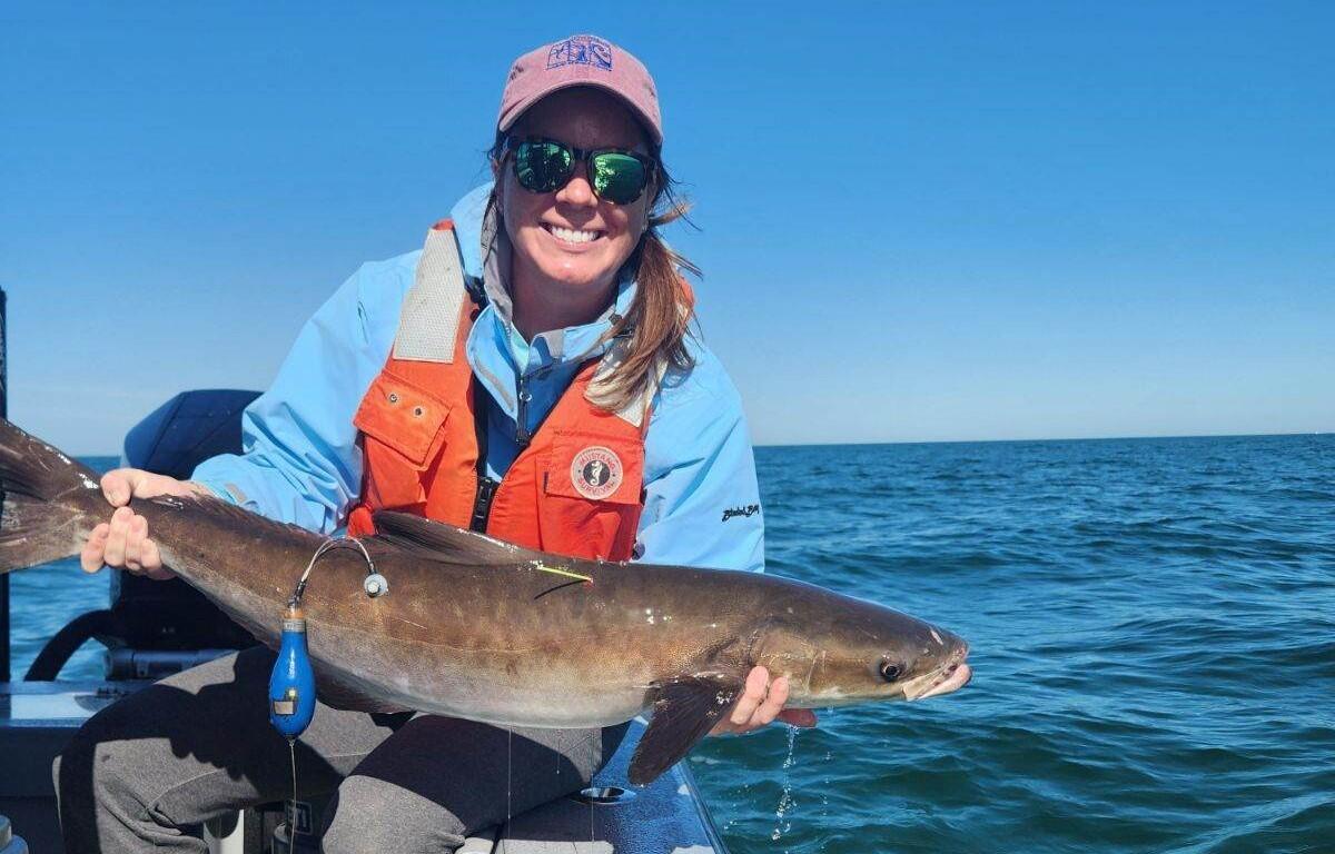
USGS WARC supports the Gulf States Marine Fisheries Commission by providing unbiased scientific information about fish communities to help guide the conservation, development, and utilization of the region's fishery resources. Tripletail and cobia are important sportfish in the Gulf; Cobia is of specific interest because of notable declines in population abundance and distribution in recent years. This decline has resulted in revenue losses for the Gulf Coast fishing industry and related businesses, and commercial harvest restrictions. Little is known about their movement or migration patterns, complicating efforts to effectively manage the drivers of their potential population decline. It has been generally accepted that cobia migrate to cooler waters during the spring and back to warmer waters in fall but there is speculation that the species is now either migrating further offshore or not migrating at all due to changing water temperatures. Water temperature affects the life history of cobia, including reproductive output and growth rates, so, alterations to their thermal niche could have population-level impacts to the species. USGS WARC scientists are collaborating with the Commission to tag and track the movement of cobia throughout the eastern Gulf to provide the information needed to inform species management and population restoration efforts.
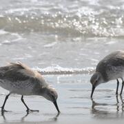
Migratory Birds
Over two billion birds representing some 500 species use habitats near or over the Gulf for all or part of the year. The northwestern Gulf, especially in areas offshore of Texas and Louisiana, hosts one of the greatest concentrations of birds in North America, with bird abundance peaking during spring and fall migrations. While much is known about bird distributions in terrestrial habitats, the abundance and distribution of birds over the open Gulf remains poorly understood. Using boat-based portable radar surveys during fall migration, USGS WARC and partners are collecting data on the abundance, distribution, and flight altitude of birds moving over the Gulf to inform offshore management and permitting practices. Radar is one of the few remote sensing technologies capable of capturing these data both day and night and the use of portable radar ensures data collection at geographic locations that directly address specific needs related to the offshore environment.


Amphibians
Because of their permeable skin, amphibians are sensitive to environmental changes, such as the presence of toxic substances, making them key indicators of ecosystem health. They also benefit agriculture by feeding upon pests, and help control mosquitos, which benefits human health. USGS WARC scientists with the USGS Amphibian Research and Monitoring Initiative provide essential scientific information to managers to help stop, or, if possible, reverse amphibian population declines, particularly for species in the Southeast and along the Gulf Coast. In St. Marks National Wildlife Refuge in the Florida Panhandle, USGS WARC is monitoring amphibians, including federally protected species such as the flatwoods salamander, to better understand the abundance, distribution, and potential impacts of changing environmental conditions on the current and future status of the populations. This project, as well as monitoring efforts on military installations along the Gulf Coast, including Eglin Air Force Base, are helping military and wildlife refuge managers effectively manage their lands to support amphibian species conservation and delisting from the Endangered Species Act, as well as bolster the military’s ability to conduct necessary training and testing on their lands.
Hypoxia and Algal Blooms
Harmful algal blooms (HABs) can have considerable recreational and economic impacts, disrupting activities like fishing and swimming while also affecting property values. In 2018, USGS estimated a HAB event bloom in Florida resulted in \$5.5 million in lost recreational opportunities and \$2.3 million in potential losses in housing sale prices. USGS WARC researchers are investigating hypoxia conditions and algal blooms and the impact that they might have on important Gulf species.
The northern Gulf's continental shelf has been home to one of the largest coastal hypoxic zones in the world since the 1970s. The low oxygen zone impacts recreationally and commercially important fisheries by diminishing their food resources and habitat, directly affecting the Gulf Region's economy. Habitat loss may lead to changes in marine food webs, energy allocation strategies of individual species, and greater vulnerability to fishing mortality. With warming conditions, understanding how temperature and oxygen interact to affect hypoxia tolerance for key species, such as brown shrimp, red drum, and red snapper, is important. USGS is developing a framework to assess how changing environmental conditions might impact key fisheries affected by hypoxia-related stress. This effort aims to provide managers the information they need to protect the ecological and economic value of the northern Gulf.
Algal blooms are another issue facing coastal waters in the northern Gulf. In Louisiana, the Bonnet Carré Spillway is frequently opened to relieve the flooding pressure that the Mississippi River puts on the levees in New Orleans. Introductions of nutrient-rich waters from the River, when combined with those from Lake Maurepas and the other local tributaries to the lake, can trigger cyanobacteria Harmful Algal Blooms (CyanoHABs). The toxins these blooms produce can harm wildlife and humans and decrease property values. As coastal and tidal waters in Louisiana undergo profound changes due to heavy rain events, warmer temperatures, and other environmental shifts, CyanoHAB impacts are likely to worsen, affecting flood control and ecosystem restoration activities associated with water resource development projects in the State and across the Nation. USGS is working with partners to assess current and past CyanoHABs to help detect and manage current and future harmful algal blooms in the northern Gulf's coastal and tidal waters.
Offshore Science
USGS WARC has been on the forefront of offshore science for decades, leading efforts to explore, map, and characterize deepwater habitats, biological resources, and potential energy resources, particularly in the Gulf. WARC scientists work closely with USGS scientists nationwide, as well as partners at BOEM, NOAA, and academic institutions to provide the information necessary for effective management of critical deepwater ecosystems, seafloor hazards, and biological and geological resources that impact human health, safety, and the economy.

Deep-sea and mesophotic ("middle" and "light;" the part of the ocean that receives minimal sunlight) ecosystems are vast and complex, and are foundational to the Gulf's food webs. Many animals, such as corals, sponges, and fish, including commercially important species, rely on mesophotic and deep-sea habitats. Despite their depth, mesophotic and deepwater ecosystems are threatened by natural disturbances and human activities.
Through a collaborative effort, USGS is working to inform restoration efforts in mesophotic and deepwater areas impacted by the Deepwater Horizon oil spill. The findings from this work will provide insight to the health, biodiversity, recovery, and resilience of mesophotic and deep sea communities following major disturbance events and support the restoration and recovery of critical species and habitats that support a healthy Gulf food web.
Invasive Species
Between 1969 and 2020, the recorded total costs of invasives species were \$1.22 trillion and the annual estimated economic and health-related costs of invasive species in the U.S. have been reported at more than \$21 billion. The impacts of invasive species include decreased agricultural production, competition with and predation on native plants and wildlife, impairment of critical water infrastructure, transmission of disease to wildlife and humans, threats to commercial and native fisheries, and reduced hunting, fishing, and other recreational opportunities such as boating and swimming.
USGS WARC works closely with local, State, Tribal, and Federal partners to provide the science they need to address the critical invasive species issues facing the southeastern U.S. USGS WARC leads research and monitoring programs and implements innovative technologies to help control or eradicate invasive species. This includes leading the development of environmental DNA tools and methods to improve the detection of hard-to-find invasive species, such as the Burmese python. USGS WARC is also expanding scientific support to Department of the Interior bureaus, such as U.S. Fish and Wildlife Service, and other partners to establish early detection and rapid response efforts to stop introduced species from spreading.
Tracking the Spread of Aquatic Invasive Species
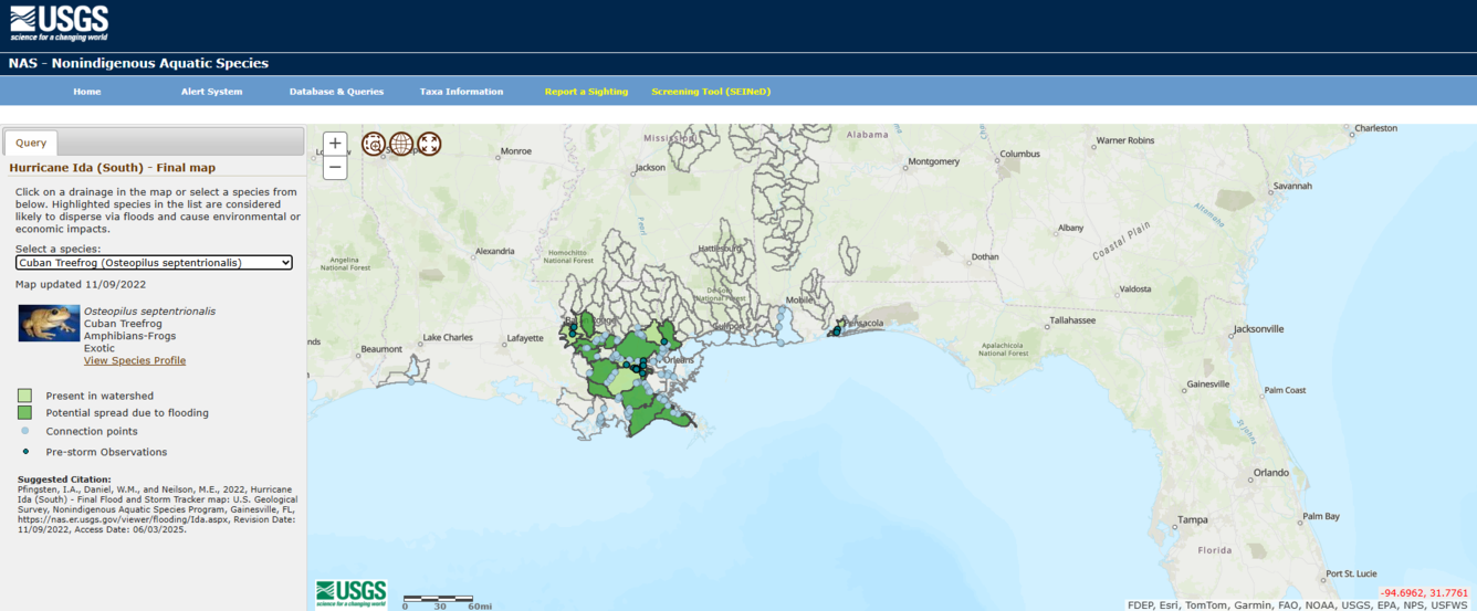
USGS WARC houses the Nonindigenous Aquatic Species (NAS) database, which tracks the distribution of introduced aquatic organisms across the United States. The publicly accessible information repository monitors, records, and analyzes reported sightings for more than 1,300 plant and animal species such as lionfish, zebra mussels, and hydrilla. The database contains observations from as early as 1800, derived from many sources, including scientific literature; Federal, State, and local natural resource monitoring programs; museum collections; news agencies; and direct submission through online reporting forms from citizen scientists. Email subscribers to NAS alerts can be informed when a new non-native species has been reported in their area as part of a national early detection and rapid response (EDRR) system. The NAS program also uses the data to help forecast geographic areas that may be vulnerable to future spread.
The NAS Flood and Storm Tracker (FaST) maps are used by municipalities and resource managers to target surveillance and rapid response actions in areas most likely to be invaded by aquatic invasive species in flood and storms events during a natural disaster. For example, the preliminary FaST map for Hurricane Helene in 2024 indicated 222 possible non-native species had the potential to spread due to storm-related flooding. The FaST maps are easily accessible, informative, and provide the most up-to-date information to resource managers about potential new invasions, acting as an additional tool for EDRR systems.
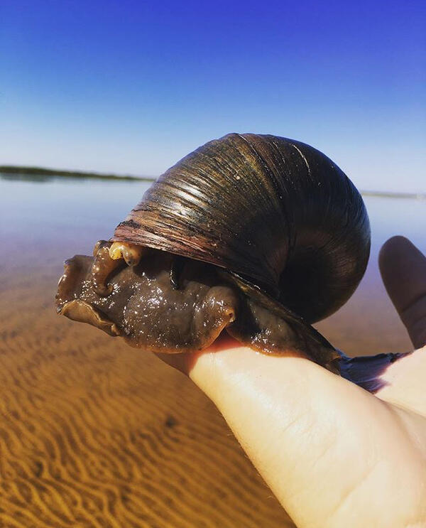
Testing Giant Apple Snail Eradication Efforts to Help Louisiana Agriculture
Native to South America, the giant apple snail was likely introduced to the southeastern U.S. by way of the aquarium trade. Certain species are established in Florida, Georgia, Texas, and Louisiana, which is of concern as they have the potential to negatively impact wetland and aquatic ecosystems, agricultural crops, and human health as they can carry parasites. In Louisiana, giant apple snails impact production on crayfish and rice farms. More than 90% of the crayfish consumed in the U.S. are produced in Louisiana, making it the largest aquaculture industry in the state, valued at over \$250 million. Removing snails is costly and requires substantial time, and can lead to a lower yield of crayfish. USGS WARC is testing various methods to limit giant apple snail hatch rates to help control the future spread and negative impacts to the crayfish industry.
Winter Shorebird Surveys of Federally Protected Bird Species Following Restoration at West Belle Headland and Trinity-East Island, Louisiana

Tracking Non-breeding Habitat Use by Dunlin, Pectoral Sandpipers, and Other Migratory Shorebirds in the Mississippi Delta

Integrating Remote Sensing and Numerical Modeling Technology to Detect and Manage Current and Future Harmful Algal Blooms in Louisiana’s Coastal and Tidal Waters

Biological Vulnerability to Hypoxia Under a Warmer Climate in the Northern Gulf

Alabama Barrier Island Restoration Assessment at Dauphin Island

Natural Resource Damage and Assessment (NRDA) Program Monitoring and Adaptive Management

Louisiana’s Coastwide Reference Monitoring System (CRMS)

A Case Study Assessing the Cumulative Effects of Deepwater Horizon Restoration Projects on Barrier Island/Barrier Shoreline Ecosystem Resilience in the North-central Gulf

Understanding Ecosystem Response and Infrastructure Vulnerability to Sea-Level Rise for Gulf Islands National Seashore

Vertical Control of Rod Surface Elevation Table (RSET) Benchmarks to Assess Implications of Sea-Level Rise within Texas Coastal Refuges

Barriers and Opportunities for Landward Migration of Coastal Wetlands along Texas' Upper and Middle Coast

NRDA: Deepwater ROV Sampling to Assess Potential Impacts to Hardbottom Coral Communities and Associates from the Deepwater Horizon Oil Spill
The USGS Wetland and Aquatic Research Center provides unbiased, actionable, and timely scientific information, expertise, and tools to support the management and restoration of natural resources on, in, and around the Gulf of America.
The Gulf of America is a major economic region for the U.S. supporting fisheries, tourism, and oil and gas activities, both onshore and offshore. The 2024 Marine Economy report from NOAA noted that the Gulf supported more than 25,000 businesses and contributed employment to more than 584,000 people, based on data from 2021. It also contributed \$133 billion gross domestic product (GDP), ranking it the greatest contributor to GDP of all 8 coastal regions. The value of the Gulf's GDP has increased 44% in the last decade and the region's offshore mineral resources provide 72% of the GDP.
The USGS Wetland and Aquatic Research Center's science directly benefits the health, safety, and economy of the Gulf region by providing trusted and timely information and innovative decision support tools to help guide restoration activities, manage fish and wildlife, address water quality concerns such as harmful algal blooms and chemical pollutants, prevent the spread of costly invasive species, and support local communities in hurricane response and recovery efforts.
Restoration
USGS researchers work with the Gulf States to guide restoration activities to ensure the wetlands, barrier islands, and other coastal habitats are healthy and sustainable, so they are able to protect the coastal communities and infrastructure from hurricanes and storm-related flooding. USGS science also helps ensure that restoration efforts are cost-efficient and effective, protecting the region’s natural resources to ensure continued contributions to the marine economy and natural heritage.
Wetlands
Coastal wetlands have immense economic value; almost all the fish and shellfish caught by the fishing industry depend on estuaries and wetlands at some point in their life cycle, and the money brought in annually by the fishing industry to the Gulf Region reaches hundreds of millions of dollars. Loss of healthy coastal wetland habitats can have severe impacts not only on fish populations, but on the fishing industry and the regional economy as well. Coastal wetlands also incur economic value from their recreational use (e.g., fishing, kayaking, hiking, birdwatching), provisioning of raw materials (e.g., food, fiber, wood), and protection (e.g., prevent erosion, protect infrastructure, filter pollution from water, reduce flooding and storm surge).
Monitoring Coastal Restoration
In Louisiana, which has experienced the greatest wetland loss of any other state in the continental U.S., USGS WARC and the State jointly lead the implementation of the Coastwide Reference Monitoring System (CRMS), which is considered the world’s largest coastal monitoring program with publicly available data. The long-term monitoring program collects data that is essential to Louisiana restoration efforts, and is used by landowners, researchers, and State and Federal agencies to plan, implement, and evaluate large-scale restoration across the Louisiana coast. Additionally, CRMS hydrology data are regularly used by the public to inform fishing and hunting conditions and have been cited by local media during flood and storm events.
Natural Resource Damage and Assessment Program
Pursuant to the Oil Pollution Act of 1990 (OPA) statutes and regulations and consistent with the Consent Decree for the Deepwater Horizon oil spill, State and Federal agencies, including USGS, are working together to restore natural resources and services injured or lost as a result of the spill. Trustees collectively determine and implement appropriate restoration actions to restore natural resources, ecological services, and recreational services. WARC science has contributed to the assessment and recovery of a variety of Gulf habitats, including deep sea sediments, nearshore, and wetland habitats; and wildlife such as fish, terrestrial and marine mammals, sea turtles, shellfish, corals, and birds.
Mapping Land Area Change in Louisiana
Louisiana has lost more than a quarter of its coastal wetlands, an area about the size of Delaware, since the 1930s. Changes to the Mississippi River and its ability to carry sediment downstream to the Gulf, coupled with sea-level rise, hurricanes, and land subsidence have contributed to the disappearance of these important ecosystems. USGS WARC scientists use historical surveys and aerial and satellite data to monitor the occurrence and rates of wetland change. By quantifying land area change over time, USGS WARC researchers are able to document and assess the short- and long-term effects of natural and anthropogenic factors on coastal wetland loss, information that natural resource managers can use to identify the areas in greatest need of restoration.
Barrier Islands
Barrier islands are dynamic environments at the land-sea interface that protect coastal communities from storm surge and coastal erosion, provide habitat for fish and wildlife, and offer opportunities for recreation and tourism. Storms, wave energy, currents, and wind are powerful forces that shape barrier islands, and with changing environmental conditions, including increased frequency and strength of hurricanes, natural resources managers and the Gulf States are concerned with the loss of barrier islands and the services they provide.
Alabama Barrier Island Restoration Assessment
The USGS, State of Alabama, and the U.S. Army Corps of Engineers conducted a joint study to evaluate the feasibility and cost of restoration alternatives to increase resiliency and sustainability of Dauphin Island, a barrier island that provides protection to much of the State of Alabama’s coastal natural resources, including one-third of the Mississippi Sound and estuarine habitats, such as oyster reefs, marshes, and seagrasses. Project findings were used to make decisions regarding which actions to take and what restoration alternatives to employ.
Mississippi Coastal Improvements Program
In Mississippi, USGS WARC is working with U.S. Army Corps of Engineers and other Federal and State agencies in developing and implementing a long-term monitoring and adaptive management program to be integrated into the Mississippi Coastal Improvements Program (MsCIP) barrier island restoration project. Mississippi's barrier islands are dynamic coastal landforms, experiencing changes in structure (land area and habitat) and geomorphic processes (erosion and accretion) due to frequent intense storms, relative rise in sea level, and changes in sediment supply. Long-term loss of the barrier islands threatens the highly productive Mississippi Sound estuarine ecosystem and exposes mainland Mississippi coast and its associated habitats to increasing saltwater intrusion and damage from future tropical storms. The MsCIP Comprehensive Plan includes the restoration of barrier islands, wetland and coastal forest habitat, among other projects to reduce future storm damage along the Mississippi Gulf Coast.
Louisiana's Barrier Island Comprehensive Monitoring
In Louisiana, USGS scientists have partnered with the Louisiana Coastal Protection Authority (CPRA) to help implement the Barrier Island Comprehensive Monitoring (BICM) program, which aims to provide long-term data that can be used to plan, design, evaluate, and maintain current and future barrier island restoration projects. One aspect of this program was the creation of habitat maps to provide a snapshot of coastal habitats to be combined with historical or future maps to monitor change over time. USGS WARC developed habitat classification schemes to monitor barrier island habitats and developed a web-based reporting tool to help natural resource managers visualize the habitat maps and habitat change maps.
Hurricanes and Storms
Coastal communities of the U.S. are home to 129 million people, or almost 40% of the nation's total population, and contribute \$10 trillion in goods and services annually. Hurricanes and intensifying storms are increasing coastal flooding, which inundates low-lying buildings, roads, and other infrastructure, destroying property and in some cases leading to the loss of life. Coastal wetlands provide key habitat to support commercial and recreational fisheries, and mitigate flooding and absorb wave energy, which can decrease property damage by up to 20%, providing \$23 billion annually in coastal protection services around the U.S.
Coastal wetlands are important ecosystems along the Gulf Coast that provide essential services such as reducing hurricane-induced floods and conserving biodiversity. However, these wetlands face potential loss and degradation due to rising sea levels, changing climate patterns, and ongoing coastal development. While wetland management and flood control agencies are developing long-term climate adaptation strategies, they require forward-looking knowledge and data about how wetlands along the Gulf Coast will evolve in the coming decades, and how they can better provide flood and storm surge protection during hurricanes.
Working closely with nine expert groups familiar with local and regional wetland management and flood control, USGS WARC scientists and partners are co-designing research and creating practical data to enhance wetland restoration and flood protection under environmental change. The researchers use remote sensing data and models to create maps depicting the current extent of coastal wetlands and how the coastal landscape might change with future conditions, coastal development, and restoration efforts. They can predict how hurricanes and the associated extreme precipitation and floods could change in the future. The project is also evaluating how effective existing wetland restoration projects are in reducing hurricane flood risks.
Fisheries and Wildlife
The Gulf is home to a diversity of fish and wildlife species, including waterfowl and key commercial and recreational fisheries. In 2022, the Gulf had the third highest commercial landings revenue (behind Alaska and New England). It contributed the greatest recreational trip expenditures (which includes shore-based fishing, boats for hires, and private guides) and the most recreational trip activity (55.2 million trips).
The Gulf also supports breeding, feeding, and resting stop-over habitat for birds along their migration route. People who appreciate birds contribute more than \$100 billion in related purchases to the U.S. economy annually, helping to support 1.4 million jobs and \$90 billion in labor-related income. WARC scientists provide the science needed to effectively manage and protect these species, as well as the habitats and food resources they rely on.
Fisheries
USGS WARC supports the Gulf States Marine Fisheries Commission by providing unbiased scientific information about fish communities to help guide the conservation, development, and utilization of the region's fishery resources. Tripletail and cobia are important sportfish in the Gulf; Cobia is of specific interest because of notable declines in population abundance and distribution in recent years. This decline has resulted in revenue losses for the Gulf Coast fishing industry and related businesses, and commercial harvest restrictions. Little is known about their movement or migration patterns, complicating efforts to effectively manage the drivers of their potential population decline. It has been generally accepted that cobia migrate to cooler waters during the spring and back to warmer waters in fall but there is speculation that the species is now either migrating further offshore or not migrating at all due to changing water temperatures. Water temperature affects the life history of cobia, including reproductive output and growth rates, so, alterations to their thermal niche could have population-level impacts to the species. USGS WARC scientists are collaborating with the Commission to tag and track the movement of cobia throughout the eastern Gulf to provide the information needed to inform species management and population restoration efforts.
Migratory Birds
Over two billion birds representing some 500 species use habitats near or over the Gulf for all or part of the year. The northwestern Gulf, especially in areas offshore of Texas and Louisiana, hosts one of the greatest concentrations of birds in North America, with bird abundance peaking during spring and fall migrations. While much is known about bird distributions in terrestrial habitats, the abundance and distribution of birds over the open Gulf remains poorly understood. Using boat-based portable radar surveys during fall migration, USGS WARC and partners are collecting data on the abundance, distribution, and flight altitude of birds moving over the Gulf to inform offshore management and permitting practices. Radar is one of the few remote sensing technologies capable of capturing these data both day and night and the use of portable radar ensures data collection at geographic locations that directly address specific needs related to the offshore environment.
Amphibians
Because of their permeable skin, amphibians are sensitive to environmental changes, such as the presence of toxic substances, making them key indicators of ecosystem health. They also benefit agriculture by feeding upon pests, and help control mosquitos, which benefits human health. USGS WARC scientists with the USGS Amphibian Research and Monitoring Initiative provide essential scientific information to managers to help stop, or, if possible, reverse amphibian population declines, particularly for species in the Southeast and along the Gulf Coast. In St. Marks National Wildlife Refuge in the Florida Panhandle, USGS WARC is monitoring amphibians, including federally protected species such as the flatwoods salamander, to better understand the abundance, distribution, and potential impacts of changing environmental conditions on the current and future status of the populations. This project, as well as monitoring efforts on military installations along the Gulf Coast, including Eglin Air Force Base, are helping military and wildlife refuge managers effectively manage their lands to support amphibian species conservation and delisting from the Endangered Species Act, as well as bolster the military’s ability to conduct necessary training and testing on their lands.
Hypoxia and Algal Blooms
Harmful algal blooms (HABs) can have considerable recreational and economic impacts, disrupting activities like fishing and swimming while also affecting property values. In 2018, USGS estimated a HAB event bloom in Florida resulted in \$5.5 million in lost recreational opportunities and \$2.3 million in potential losses in housing sale prices. USGS WARC researchers are investigating hypoxia conditions and algal blooms and the impact that they might have on important Gulf species.
The northern Gulf's continental shelf has been home to one of the largest coastal hypoxic zones in the world since the 1970s. The low oxygen zone impacts recreationally and commercially important fisheries by diminishing their food resources and habitat, directly affecting the Gulf Region's economy. Habitat loss may lead to changes in marine food webs, energy allocation strategies of individual species, and greater vulnerability to fishing mortality. With warming conditions, understanding how temperature and oxygen interact to affect hypoxia tolerance for key species, such as brown shrimp, red drum, and red snapper, is important. USGS is developing a framework to assess how changing environmental conditions might impact key fisheries affected by hypoxia-related stress. This effort aims to provide managers the information they need to protect the ecological and economic value of the northern Gulf.
Algal blooms are another issue facing coastal waters in the northern Gulf. In Louisiana, the Bonnet Carré Spillway is frequently opened to relieve the flooding pressure that the Mississippi River puts on the levees in New Orleans. Introductions of nutrient-rich waters from the River, when combined with those from Lake Maurepas and the other local tributaries to the lake, can trigger cyanobacteria Harmful Algal Blooms (CyanoHABs). The toxins these blooms produce can harm wildlife and humans and decrease property values. As coastal and tidal waters in Louisiana undergo profound changes due to heavy rain events, warmer temperatures, and other environmental shifts, CyanoHAB impacts are likely to worsen, affecting flood control and ecosystem restoration activities associated with water resource development projects in the State and across the Nation. USGS is working with partners to assess current and past CyanoHABs to help detect and manage current and future harmful algal blooms in the northern Gulf's coastal and tidal waters.
Offshore Science
USGS WARC has been on the forefront of offshore science for decades, leading efforts to explore, map, and characterize deepwater habitats, biological resources, and potential energy resources, particularly in the Gulf. WARC scientists work closely with USGS scientists nationwide, as well as partners at BOEM, NOAA, and academic institutions to provide the information necessary for effective management of critical deepwater ecosystems, seafloor hazards, and biological and geological resources that impact human health, safety, and the economy.
Deep-sea and mesophotic ("middle" and "light;" the part of the ocean that receives minimal sunlight) ecosystems are vast and complex, and are foundational to the Gulf's food webs. Many animals, such as corals, sponges, and fish, including commercially important species, rely on mesophotic and deep-sea habitats. Despite their depth, mesophotic and deepwater ecosystems are threatened by natural disturbances and human activities.
Through a collaborative effort, USGS is working to inform restoration efforts in mesophotic and deepwater areas impacted by the Deepwater Horizon oil spill. The findings from this work will provide insight to the health, biodiversity, recovery, and resilience of mesophotic and deep sea communities following major disturbance events and support the restoration and recovery of critical species and habitats that support a healthy Gulf food web.
Invasive Species
Between 1969 and 2020, the recorded total costs of invasives species were \$1.22 trillion and the annual estimated economic and health-related costs of invasive species in the U.S. have been reported at more than \$21 billion. The impacts of invasive species include decreased agricultural production, competition with and predation on native plants and wildlife, impairment of critical water infrastructure, transmission of disease to wildlife and humans, threats to commercial and native fisheries, and reduced hunting, fishing, and other recreational opportunities such as boating and swimming.
USGS WARC works closely with local, State, Tribal, and Federal partners to provide the science they need to address the critical invasive species issues facing the southeastern U.S. USGS WARC leads research and monitoring programs and implements innovative technologies to help control or eradicate invasive species. This includes leading the development of environmental DNA tools and methods to improve the detection of hard-to-find invasive species, such as the Burmese python. USGS WARC is also expanding scientific support to Department of the Interior bureaus, such as U.S. Fish and Wildlife Service, and other partners to establish early detection and rapid response efforts to stop introduced species from spreading.
Tracking the Spread of Aquatic Invasive Species
USGS WARC houses the Nonindigenous Aquatic Species (NAS) database, which tracks the distribution of introduced aquatic organisms across the United States. The publicly accessible information repository monitors, records, and analyzes reported sightings for more than 1,300 plant and animal species such as lionfish, zebra mussels, and hydrilla. The database contains observations from as early as 1800, derived from many sources, including scientific literature; Federal, State, and local natural resource monitoring programs; museum collections; news agencies; and direct submission through online reporting forms from citizen scientists. Email subscribers to NAS alerts can be informed when a new non-native species has been reported in their area as part of a national early detection and rapid response (EDRR) system. The NAS program also uses the data to help forecast geographic areas that may be vulnerable to future spread.
The NAS Flood and Storm Tracker (FaST) maps are used by municipalities and resource managers to target surveillance and rapid response actions in areas most likely to be invaded by aquatic invasive species in flood and storms events during a natural disaster. For example, the preliminary FaST map for Hurricane Helene in 2024 indicated 222 possible non-native species had the potential to spread due to storm-related flooding. The FaST maps are easily accessible, informative, and provide the most up-to-date information to resource managers about potential new invasions, acting as an additional tool for EDRR systems.
Testing Giant Apple Snail Eradication Efforts to Help Louisiana Agriculture
Native to South America, the giant apple snail was likely introduced to the southeastern U.S. by way of the aquarium trade. Certain species are established in Florida, Georgia, Texas, and Louisiana, which is of concern as they have the potential to negatively impact wetland and aquatic ecosystems, agricultural crops, and human health as they can carry parasites. In Louisiana, giant apple snails impact production on crayfish and rice farms. More than 90% of the crayfish consumed in the U.S. are produced in Louisiana, making it the largest aquaculture industry in the state, valued at over \$250 million. Removing snails is costly and requires substantial time, and can lead to a lower yield of crayfish. USGS WARC is testing various methods to limit giant apple snail hatch rates to help control the future spread and negative impacts to the crayfish industry.
Winter Shorebird Surveys of Federally Protected Bird Species Following Restoration at West Belle Headland and Trinity-East Island, Louisiana
Tracking Non-breeding Habitat Use by Dunlin, Pectoral Sandpipers, and Other Migratory Shorebirds in the Mississippi Delta
Integrating Remote Sensing and Numerical Modeling Technology to Detect and Manage Current and Future Harmful Algal Blooms in Louisiana’s Coastal and Tidal Waters
Biological Vulnerability to Hypoxia Under a Warmer Climate in the Northern Gulf
Alabama Barrier Island Restoration Assessment at Dauphin Island
Natural Resource Damage and Assessment (NRDA) Program Monitoring and Adaptive Management
Louisiana’s Coastwide Reference Monitoring System (CRMS)
A Case Study Assessing the Cumulative Effects of Deepwater Horizon Restoration Projects on Barrier Island/Barrier Shoreline Ecosystem Resilience in the North-central Gulf
Understanding Ecosystem Response and Infrastructure Vulnerability to Sea-Level Rise for Gulf Islands National Seashore
Vertical Control of Rod Surface Elevation Table (RSET) Benchmarks to Assess Implications of Sea-Level Rise within Texas Coastal Refuges
Barriers and Opportunities for Landward Migration of Coastal Wetlands along Texas' Upper and Middle Coast