
The 2004 Indian Ocean, 2010 Chilean, and 2011 Tohoku disasters have shown how tsunamis are significant threats to coastal communities. To help U.S. coastal communities prepare for future tsunamis, the Hazards Vulnerability Team completed projects related to population exposure and sensitivity, pedestrian evacuation modeling, and vertical-evacuation decision support.
A recent article of ours in the Proceedings of the National Academy of Sciences captures many aspects of our tsunami-related research. Focusing on tsunamis associated with a Cascadia subduction zone earthquake in the U.S. Pacific Northwest, the article integrates GIS methods to identify the number and characteristics of people in hazard zones, evacuation modeling to estimate travel times to safety, and cluster analysis to classify communities with similar vulnerability. Results can be used to enhance general tsunami-awareness efforts with targeted interventions, such as education and outreach tailored to local demographics, evacuation training, and/or vertical evacuation refuges.
- How many people live and work in tsunami-zones in my community?
- Will people have enough time to evacuate before tsunami waves arrive?
- If people don’t have enough time to evacuate to high ground, where can vertical-evacuation refuges be built?
- How can GIS be used to map hot-spots of community exposure to tsunami hazards?
- Can we identify and map certain types of people that may have greater difficulty preparing, responding, and recovering from tsunamis?
- How can technical expertise be integrated with local input to better understand how coastal communities are vulnerable to tsunami hazards?
- How do people perceive the risks posed by tsunami hazards along the Pacific Northwest coast?
- How prepared is the nation for future tsunamis, in terms of the tsunami warning system and community readiness?
How many people live and work in tsunami-zones in my community?
- We have used geospatial tools to estimate the number and type of people, businesses, and land cover in the maximum tsunami-hazard zones of Oregon, Hawaii,California, and the open-ocean coast of Washington. In each report, coastal communities within a State are compared in terms of the number and community percentage of populations and assets in tsunami-hazard zones. This information helps public officials understand the scope and breadth of vulnerability issues in their community, but also across multiple jurisdictions.
- We also examined population vulnerability and evacuation issues related to the SAFFR tsunami scenario, which focuses on impacts along the California coast from a distant Alaskan earthquake.

Will people have enough time to evacuate before tsunami waves arrive?
- In collaboration with Sacramento State University, we completed evacuation modeling in southwest Washington related to Cascadia threats, including a study on model development and sensitivity and an assessment of population exposure in several Washington communities as a function of travel time to safety.
- Our pedestrian evacuation modeling for Westport, Washington, was featured in a 2014 issue of National Geographic.
- We did pedestrian evacuation modeling in Seward, Alaska, to examine modern evacuation potential to tsunami hazards but looked also at historic conditions prior to the 1964 Good Friday earthquake and tsunami disaster.
- To help others do their own pedestrian-evacuation modeling, we’ve created a GIS tool.

In collaboration with the State of Washington Emergency Management Division and Sacramento State University, we integrated evacuation modeling and results of community workshops to develop a framework for deciding how to compare vertical-evacuation refuge options. As a case study, we demonstrate this decision support for the coastal community of Ocean Shores, Washington, which is threatened by local tsunamis associated with Cascadia subduction zone earthquakes.

How can GIS be used to map hot-spots of community exposure to tsunami hazards?

- We demonstrated how to use midresolution land-cover data to estimate and compare community exposure to tsunami-hazards along the Oregon coast. This approach could be useful in determining where to allocate disaster response and relief resources over large areas when time does not allow for detailed socioeconomic analysis.
- We have demonstrated how to use a wide range of hazard and societal data in one coastal community to identify and map potential vulnerability hot-spots. This helps local officials target sites for risk-reduction efforts.
- We’ve used dasymetric mapping techniques to better map population exposure to tsunami hazards. This is useful for providing a more realistic distribution of people in hazard zones than relying on coarser census units.
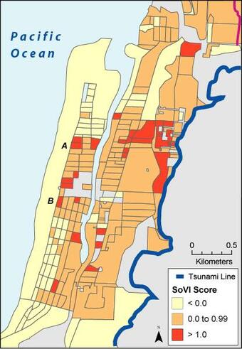
In collaboration with the University of South Carolina, we combined geospatial tools with statistical factor analysis to understand and map hot-spots of demographic sensitivity to Cascadia tsunamis along the Oregon coast. This information can be used to develop targeted outreach and preparedness training that address local needs.

- We held a community workshop in Newport, Oregon, to collectively assess societal impacts and risk-reduction opportunities for a Cascadia tsunami hazard. The workshop demonstrated the importance of integrating technical expertise on earthquake and tsunami processes with local perspectives of risk and community values.
- Another community workshop in collaboration with the University of Oregon was held in Cannon Beach, Oregon, to discuss post-disaster recovery planning from a Cascadia tsunami.
How do people perceive the risks posed by tsunami hazards along the Pacific Northwest coast?
- Public officials and key private sector individuals in Oregon and Washington coastal communities were asked in 2001 to reflect on the perceived risk to Cascadia subduction zone earthquakes and tsunamis. A key finding was that although hazard awareness was high, few individuals had taken steps to reduce their vulnerabilities.
- In collaboration with East Tennessee State University, survivors in American Samoa from the 2009 Samoan tsunami disaster were interviewed to better understand people’s ability to self-initiate evacuations from tsunamis. We were interested in learning about how individuals knew to take self-protective action and what influenced that decision making process.
- USGS research geographer Nathan Wood was a member of a recent National Research Council committee asked to review of U.S. tsunami warning system and national preparedness to tsunamis. The report covers recommendations for hazard and vulnerability assessments, tsunami detection, warning dissemination, and community preparedness.
- Related, Dr. Wood was asked by the Los Angeles Times to write an opinion piece on the readiness of West Coast communities immediately after the 2011 Tohoku tsunami disaster.
The 2004 Indian Ocean, 2010 Chilean, and 2011 Tohoku disasters have shown how tsunamis are significant threats to coastal communities. To help U.S. coastal communities prepare for future tsunamis, the Hazards Vulnerability Team completed projects related to population exposure and sensitivity, pedestrian evacuation modeling, and vertical-evacuation decision support.
A recent article of ours in the Proceedings of the National Academy of Sciences captures many aspects of our tsunami-related research. Focusing on tsunamis associated with a Cascadia subduction zone earthquake in the U.S. Pacific Northwest, the article integrates GIS methods to identify the number and characteristics of people in hazard zones, evacuation modeling to estimate travel times to safety, and cluster analysis to classify communities with similar vulnerability. Results can be used to enhance general tsunami-awareness efforts with targeted interventions, such as education and outreach tailored to local demographics, evacuation training, and/or vertical evacuation refuges.
- How many people live and work in tsunami-zones in my community?
- Will people have enough time to evacuate before tsunami waves arrive?
- If people don’t have enough time to evacuate to high ground, where can vertical-evacuation refuges be built?
- How can GIS be used to map hot-spots of community exposure to tsunami hazards?
- Can we identify and map certain types of people that may have greater difficulty preparing, responding, and recovering from tsunamis?
- How can technical expertise be integrated with local input to better understand how coastal communities are vulnerable to tsunami hazards?
- How do people perceive the risks posed by tsunami hazards along the Pacific Northwest coast?
- How prepared is the nation for future tsunamis, in terms of the tsunami warning system and community readiness?
How many people live and work in tsunami-zones in my community?
- We have used geospatial tools to estimate the number and type of people, businesses, and land cover in the maximum tsunami-hazard zones of Oregon, Hawaii,California, and the open-ocean coast of Washington. In each report, coastal communities within a State are compared in terms of the number and community percentage of populations and assets in tsunami-hazard zones. This information helps public officials understand the scope and breadth of vulnerability issues in their community, but also across multiple jurisdictions.
- We also examined population vulnerability and evacuation issues related to the SAFFR tsunami scenario, which focuses on impacts along the California coast from a distant Alaskan earthquake.
Will people have enough time to evacuate before tsunami waves arrive?
- In collaboration with Sacramento State University, we completed evacuation modeling in southwest Washington related to Cascadia threats, including a study on model development and sensitivity and an assessment of population exposure in several Washington communities as a function of travel time to safety.
- Our pedestrian evacuation modeling for Westport, Washington, was featured in a 2014 issue of National Geographic.
- We did pedestrian evacuation modeling in Seward, Alaska, to examine modern evacuation potential to tsunami hazards but looked also at historic conditions prior to the 1964 Good Friday earthquake and tsunami disaster.
- To help others do their own pedestrian-evacuation modeling, we’ve created a GIS tool.
In collaboration with the State of Washington Emergency Management Division and Sacramento State University, we integrated evacuation modeling and results of community workshops to develop a framework for deciding how to compare vertical-evacuation refuge options. As a case study, we demonstrate this decision support for the coastal community of Ocean Shores, Washington, which is threatened by local tsunamis associated with Cascadia subduction zone earthquakes.
How can GIS be used to map hot-spots of community exposure to tsunami hazards?
- We demonstrated how to use midresolution land-cover data to estimate and compare community exposure to tsunami-hazards along the Oregon coast. This approach could be useful in determining where to allocate disaster response and relief resources over large areas when time does not allow for detailed socioeconomic analysis.
- We have demonstrated how to use a wide range of hazard and societal data in one coastal community to identify and map potential vulnerability hot-spots. This helps local officials target sites for risk-reduction efforts.
- We’ve used dasymetric mapping techniques to better map population exposure to tsunami hazards. This is useful for providing a more realistic distribution of people in hazard zones than relying on coarser census units.
In collaboration with the University of South Carolina, we combined geospatial tools with statistical factor analysis to understand and map hot-spots of demographic sensitivity to Cascadia tsunamis along the Oregon coast. This information can be used to develop targeted outreach and preparedness training that address local needs.
- We held a community workshop in Newport, Oregon, to collectively assess societal impacts and risk-reduction opportunities for a Cascadia tsunami hazard. The workshop demonstrated the importance of integrating technical expertise on earthquake and tsunami processes with local perspectives of risk and community values.
- Another community workshop in collaboration with the University of Oregon was held in Cannon Beach, Oregon, to discuss post-disaster recovery planning from a Cascadia tsunami.
How do people perceive the risks posed by tsunami hazards along the Pacific Northwest coast?
- Public officials and key private sector individuals in Oregon and Washington coastal communities were asked in 2001 to reflect on the perceived risk to Cascadia subduction zone earthquakes and tsunamis. A key finding was that although hazard awareness was high, few individuals had taken steps to reduce their vulnerabilities.
- In collaboration with East Tennessee State University, survivors in American Samoa from the 2009 Samoan tsunami disaster were interviewed to better understand people’s ability to self-initiate evacuations from tsunamis. We were interested in learning about how individuals knew to take self-protective action and what influenced that decision making process.
- USGS research geographer Nathan Wood was a member of a recent National Research Council committee asked to review of U.S. tsunami warning system and national preparedness to tsunamis. The report covers recommendations for hazard and vulnerability assessments, tsunami detection, warning dissemination, and community preparedness.
- Related, Dr. Wood was asked by the Los Angeles Times to write an opinion piece on the readiness of West Coast communities immediately after the 2011 Tohoku tsunami disaster.