
COAWST: A Coupled-Ocean-Atmosphere-Wave-Sediment Transport Modeling System
Coupled Ocean-Atmosphere-Wave-Sediment Transport
COAWST Modeling System
Understanding the processes responsible for coastal change is important for managing both our natural and economic coastal resources. Storms are one of the primary driving forces causing coastal change from a coupling of wave- and wind-driven flows.
To better understand storm impacts and their effects on our coastlines, there is an international need to better predict storm paths and intensities.
The USGS is addressing this need by leading the development of the Coupled Ocean–Atmosphere–Waves–Sediment Transport (COAWST) Modeling System.
Applications Catalog
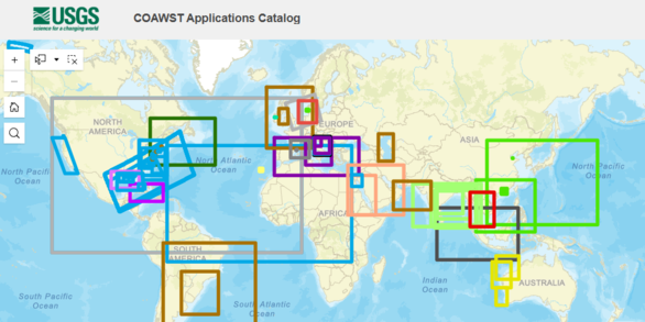
A curated collection of published COAWST-based studies from around the world.
Training Workshops

Training workshops are held every two years to help advance the user community.

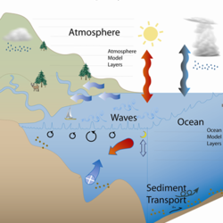
COAWST is an open-source tool that combines many sophisticated systems that each provide relative earth-system components necessary to investigate the dynamics of coastal storm impacts. Specifically, the COAWST Modeling System includes an ocean component—Regional Ocean Modeling System (ROMS); atmosphere component—Weather Research and Forecast Model (WRF), hydrology component- WRF_Hydro; wave components—Simulating Waves Nearshore (SWAN), WAVEWATCHIII, and InWave; a sediment component—the USGS Community Sediment Models; and a sea ice model.
Visit the COAWST System Components web page to learn more about each component.
We began with a coupled modeling system as described in Warner et al (2008) and have enhanced that system to include concurrent one-way grid refinement in the ocean model, concurrent one-way grid refinement in the wave model, coupling an atmospheric model to include effects of sea surface temperature and waves, exchange of fields on refined grid levels, and interpolation mechanisms to allow the different models to compute on different grids. Full description provided in Warner et al (2010).
The USGS has provided and developed varying aspects of all these individual systems and provided enhanced capabilities to allow these components to feed back to one another. For example, a typical hurricane modeling simulation may include great details for the atmosphere component, but with limited connectivity to the ocean. However, with the COAWST system, these simulations will allow the ocean and waves to dynamically evolve and provide a feedback to the atmosphere simulation. This will modify the storm development and provide a more realistic suite of physical storm processes.
COAWST related resources
COAWST Training Workshops

COAWST System Components
Understanding the processes responsible for coastal change is important for managing both our natural and economic coastal resources. Storms are one of the primary driving forces causing coastal change from a coupling of wave- and wind-driven flows.
To better understand storm impacts and their effects on our coastlines, there is an international need to better predict storm paths and intensities.
The USGS is addressing this need by leading the development of the Coupled Ocean–Atmosphere–Waves–Sediment Transport (COAWST) Modeling System.
Applications Catalog
A curated collection of published COAWST-based studies from around the world.
Training Workshops
Training workshops are held every two years to help advance the user community.
COAWST is an open-source tool that combines many sophisticated systems that each provide relative earth-system components necessary to investigate the dynamics of coastal storm impacts. Specifically, the COAWST Modeling System includes an ocean component—Regional Ocean Modeling System (ROMS); atmosphere component—Weather Research and Forecast Model (WRF), hydrology component- WRF_Hydro; wave components—Simulating Waves Nearshore (SWAN), WAVEWATCHIII, and InWave; a sediment component—the USGS Community Sediment Models; and a sea ice model.
Visit the COAWST System Components web page to learn more about each component.
We began with a coupled modeling system as described in Warner et al (2008) and have enhanced that system to include concurrent one-way grid refinement in the ocean model, concurrent one-way grid refinement in the wave model, coupling an atmospheric model to include effects of sea surface temperature and waves, exchange of fields on refined grid levels, and interpolation mechanisms to allow the different models to compute on different grids. Full description provided in Warner et al (2010).
The USGS has provided and developed varying aspects of all these individual systems and provided enhanced capabilities to allow these components to feed back to one another. For example, a typical hurricane modeling simulation may include great details for the atmosphere component, but with limited connectivity to the ocean. However, with the COAWST system, these simulations will allow the ocean and waves to dynamically evolve and provide a feedback to the atmosphere simulation. This will modify the storm development and provide a more realistic suite of physical storm processes.
COAWST related resources
COAWST Training Workshops