
National Shoreline Change Data Publication Catalog
The U.S. Geological Survey (USGS) maintains shoreline positions for the United States from older sources, such as aerial photos and topographic surveys, and contemporary sources like digital elevation models (DEMs) and lidar elevation point cloud data.
It's important to maintain, and make available, records of historical shoreline positions to allow monitoring of change over time, and to identify areas most susceptible to erosion or accretion.
Published USGS shoreline change materials are listed under the Data and Publications tabs. They are also listed by state below.
Digital Shoreline Analysis System (DSAS)
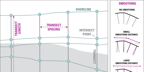
Software used to compute shoreline position rates-of-change.
National Shoreline Change geonarrative
Detailed overview of data sources and shoreline extraction and change analysis.
National
Henderson, R.E., Kratzmann, M.G., Heslin, J. L., Farris, A.S., Himmelstoss, E.A., Bartlett, M.K., Thieler, E.R., Weber, K.M., and Lentz, E.E. (2026). USGS National Shoreline Change - A compilation of published shoreline change rates (1800s-2010s) for the contiguous United States: U.S. Geological Survey data release, https://doi.org/10.5066/P14MTEZ3.
Alabama
Kratzmann, M.G., Farris, A.S., and Weber, K.M., 2026, National Shoreline Change—A GIS compilation of vector shorelines and associated shoreline change data from the 1800s to the 2020s for the coast of Alabama: U.S. Geological Survey data release, https://doi.org/10.5066/P1JE2KSO.
Previous publications
Himmelstoss, E.A., Kratzmann, M.G., and Thieler, E.R., 2017, National assessment of shoreline change – A GIS compilation of updated vector shorelines and associated shoreline change data for the Gulf of Mexico: U.S. Geological Survey data release, https://doi.org/10.5066/F78P5XNK.
Henderson, R.E, Nelson, P. R., Long, J.W., and Smith, C., 2017, Vector shorelines and associated shoreline change rates derived from lidar and aerial imagery for Dauphin Island, Alabama: 1940–2015: U.S. Geological Survey data release, https://doi.org/10.5066/F7T43RB5.
Miller, T.L., Morton, R.A., Sallenger, A.H., Moore, L.J., 2004, The National Assessment of Shoreline Change: A GIS Compilation of Vector Shorelines and Associated Shoreline Change Data for the U.S. Gulf of Mexico: USGS Open File Report 2004-1089, https://doi.org/10.3133/ofr20041089.
Alaska
Gibbs, A.E., Snyder, A.G., and Nieminski, N.M., 2026, National Assessment of Shoreline Change: A GIS compilation of updated vector shorelines (1949 to 2015) and associated shoreline change data for the west coast of Alaska, Cape Prince of Wales to Kotlik River: U.S. Geological Survey data release, https://doi.org/10.5066/P1RYHDR7.
Snyder, A.G., and Gibbs, A.E., 2019, National assessment of shoreline change: A GIS compilation of updated vector shorelines and associated shoreline change data for the north coast of Alaska, Icy Cape to Cape Prince of Wales: U.S. Geological Survey data release, https://doi.org/10.5066/P9H1S1PV.
Gibbs, A.E., Ohman, K.A., Coppersmith, R., and Richmond, B.M., 2017, National Assessment of Shoreline Change: A GIS compilation of updated vector shorelines and associated shoreline change data for the north coast of Alaska, U.S. Canadian border to Icy Cape (ver. 2.0, September 2024): U.S. Geological Survey data release, https://doi.org/10.5066/F72Z13N1.
Previous publications
Gibbs, A.E., Ohman, K.A., and Richmond, B.M., 2015, National assessment of shoreline change—A GIS compilation of vector shorelines and associated shoreline change data for the north coast of Alaska, U.S.-Canadian border to Icy Cape: U.S. Geological Survey Open-File Report 2015-1030, https://doi.org/10.3133/ofr20151030.
California
Kratzmann, M.G., Farris, A.S., and Himmelstoss, E.A., 2024, National Shoreline Change—A GIS compilation of vector shorelines and associated shoreline change data from the 1800s to 2010s for the coast of California: U.S. Geological Survey data release, https://doi.org/10.5066/P94J0K7Z.
Barnard, P.L., Smith, S.A., and Foxgrover, A.C., 2020, California shorelines and shoreline change data, 1998-2016: U.S. Geological Survey data release, https://doi.org/10.5066/P91QSGXF.
Previous publications
Hapke, C., and Reid, D., 2006, The National Assessment of Shoreline Change — A GIS Compilation of Vector Shorelines and Associated Shoreline Change Data for the Sandy Shorelines of the California Coast: U.S. Geological Survey Open-File Report 2006–1251, https://doi.org/10.3133/ofr20061251.
Connecticut
Henderson, R.E., Kratzmann, M.G., Farris, A.S., Lentz, E.E., and Himmelstoss, E.A., 2025, National Shoreline Change—A GIS compilation of vector shorelines and associated shoreline change data from the 1800s to the 2010s for the coast of Long Island Sound, New York and Connecticut: U.S. Geological Survey data release, https://doi.org/10.5066/P1TKEDFX.
Delaware
Himmelstoss, E.A., Kratzmann, M., Hapke, C., Thieler, E.R., and List, J., 2010, The national assessment of shoreline change: A GIS compilation of vector shorelines and associated shoreline change data for the New England and Mid-Atlantic Coasts: U.S. Geological Survey Open-File Report 2010–1119, https://doi.org/10.3133/ofr20101119.
Florida
Kratzmann, M.G., Farris, A.S., Weber, K.M., Henderson, R.E., and Himmelstoss, E.A., 2021, USGS National Shoreline Change: A GIS compilation of Updated Vector Shorelines (1800s - 2010s) and Associated Shoreline Change Data for the Georgia and Florida Coasts: U.S. Geological Survey data release, https://doi.org/10.5066/P9J3CVN4.
Previous publications
Kratzmann, M.G., Himmelstoss, E.A., and Thieler, E.R., 2017, National assessment of shoreline change – A GIS compilation of updated vector shorelines and associated shoreline change data for the Southeast Atlantic Coast: U.S. Geological Survey data release, https://doi.org/10.5066/F74X55X7.
Himmelstoss, E.A., Kratzmann, M.G., and Thieler, E.R., 2017, National assessment of shoreline change – A GIS compilation of updated vector shorelines and associated shoreline change data for the Gulf of Mexico: U.S. Geological Survey data release, https://doi.org/10.5066/F78P5XNK.
Miller, T.L., Morton, R.A., Sallenger, A.H., 2005, The National Assessment of Shoreline Change: A GIS Compilation of Vector Shorelines and Associated Shoreline Change Data for the U.S. Southeast Atlantic Coast: U.S. Geological Survey Open-file Report 2005-1326, https://doi.org/10.3133/ofr20051326.
Miller, T.L., Morton, R.A., Sallenger, A.H., Moore, L.J., 2004, The National Assessment of Shoreline Change: A GIS Compilation of Vector Shorelines and Associated Shoreline Change Data for the U.S. Gulf of Mexico: USGS Open File Report 2004-1089, https://doi.org/10.3133/ofr20041089.
Georgia
Kratzmann, M.G., Farris, A.S., Weber, K.M., Henderson, R.E., and Himmelstoss, E.A., 2021, USGS National Shoreline Change: A GIS compilation of Updated Vector Shorelines (1800s - 2010s) and Associated Shoreline Change Data for the Georgia and Florida Coasts: U.S. Geological Survey data release, https://doi.org/10.5066/P9J3CVN4.
Previous publications
Kratzmann, M.G., Himmelstoss, E.A., and Thieler, E.R., 2017, National assessment of shoreline change – A GIS compilation of updated vector shorelines and associated shoreline change data for the Southeast Atlantic Coast: U.S. Geological Survey data release, https://doi.org/10.5066/F74X55X7.
Miller, T.L., Morton, R.A., Sallenger, A.H., 2005, The National Assessment of Shoreline Change: A GIS Compilation of Vector Shorelines and Associated Shoreline Change Data for the U.S. Southeast Atlantic Coast: U.S. Geological Survey Open-file Report 2005-1326, https://doi.org/10.3133/ofr20051326.
Hawaii
Romine, B.M., Fletcher, C.H., Genz, A.S., Barbee, M.M., Dyer, Matthew, Anderson, T.R., Lim, S.C., Vitousek, Sean, Bochicchio, Christopher, and Richmond, B.M., 2012, National Assessment of Shoreline Change: A GIS compilation of vector shorelines and associated shoreline change data for the sandy shorelines of Kauai, Oahu, and Maui, Hawaii: U.S. Geological Survey Open-File Report 2011-1009, available online at https://doi.org/10.3133/ofr20111009.
Louisiana
Himmelstoss, E.A., Kratzmann, M.G., and Thieler, E.R., 2017, National assessment of shoreline change – A GIS compilation of updated vector shorelines and associated shoreline change data for the Gulf of Mexico coast: U.S. Geological Survey data release, https://doi.org/10.5066/F78P5XNK.
Previous publications
Miller, T.L., Morton, R.A., Sallenger, A.H., Moore, L.J., 2004, The National Assessment of Shoreline Change: A GIS Compilation of Vector Shorelines and Associated Shoreline Change Data for the U.S. Gulf of Mexico: USGS Open File Report 2004-1089, https://doi.org/10.3133/ofr20041089.
Maine
Himmelstoss, E.A., Kratzmann, M., Hapke, C., Thieler, E.R., and List, J., 2010, The national assessment of shoreline change: A GIS compilation of vector shorelines and associated shoreline change data for the New England and Mid-Atlantic Coasts: U.S. Geological Survey Open-File Report 2010–1119, https://doi.org/10.3133/ofr20101119.
Maryland
Himmelstoss, E.A., Kratzmann, M., Hapke, C., Thieler, E.R., and List, J., 2010, The national assessment of shoreline change: A GIS compilation of vector shorelines and associated shoreline change data for the New England and Mid-Atlantic Coasts: U.S. Geological Survey Open-File Report 2010–1119, https://doi.org/10.3133/ofr20101119.
Massachusetts
Bartlett, M.K., Henderson, R.E., Farris, A.S., and Himmelstoss, E.A., 2021, Massachusetts shoreline change project, 2021 update - A GIS compilation of shoreline change rates calculated using Digital Shoreline Analysis System version 5.1, with supplementary intersects and baselines for Massachusetts: U.S. Geological Survey data release, https://doi.org/10.5066/P9YGIYFX.
Bartlett, M.K., Farris, A.S., Weber, K.M., and Himmelstoss, E.A., 2021, Massachusetts shoreline change project—A GIS compilation of vector shorelines (1844-2014): U.S. Geological Survey data release, https://doi.org/10.5066/P9O8QA8N.
Previous publications
Himmelstoss, E.A., Farris, A.S., Weber, K.M., and Henderson, R.E., 2019, Massachusetts shoreline change project, 2018 update–A GIS compilation of shoreline change rates calculated using Digital Shoreline Analysis System version 5.0, with supplementary intersects and baselines for Massachusetts (ver. 2.0, August 2019): U.S. Geological Survey data release, https://doi.org/10.5066/P9RRBEYK.
Himmelstoss, E.A., Farris, A.S., and Weber, K.M., 2018, Massachusetts shoreline change project: A GIS compilation of vector shorelines for the 2018 update: U.S. Geological Survey data release, https://doi.org/10.5066/P9O7S72B.
Smith, T.L., Himmelstoss, E.A., and Thieler, E.R., 2013, Massachusetts shoreline change project—A GIS compilation of vector shorelines and associated shoreline change data for the 2013 update: U.S. Geological Survey Open-File Report 2012–1183, https://doi.org/10.3133/ofr20121183.
Himmelstoss, E.A., Kratzmann, M., Hapke, C., Thieler, E.R., and List, J., 2010, The national assessment of shoreline change: A GIS compilation of vector shorelines and associated shoreline change data for the New England and Mid-Atlantic Coasts: U.S. Geological Survey Open-File Report 2010–1119, https://doi.org/10.3133/ofr20101119.
Mississippi
Himmelstoss, E.A., Kratzmann, M.G., and Thieler, E.R., 2017, National assessment of shoreline change – A GIS compilation of updated vector shorelines and associated shoreline change data for the Gulf of Mexico coast: U.S. Geological Survey data release, https://doi.org/10.5066/F78P5XNK.
Previous publications
Miller, T.L., Morton, R.A., Sallenger, A.H., Moore, L.J., 2004, The National Assessment of Shoreline Change: A GIS Compilation of Vector Shorelines and Associated Shoreline Change Data for the U.S. Gulf of Mexico: USGS Open File Report 2004-1089, https://doi.org/10.3133/ofr20041089.
New Hampshire
Himmelstoss, E.A., Kratzmann, M., Hapke, C., Thieler, E.R., and List, J., 2010, The national assessment of shoreline change: A GIS compilation of vector shorelines and associated shoreline change data for the New England and Mid-Atlantic Coasts: U.S. Geological Survey Open-File Report 2010–1119, https://doi.org/10.3133/ofr20101119.
New York
Henderson, R.E., Kratzmann, M.G., Farris, A.S., Lentz, E.E., and Himmelstoss, E.A., 2025, National Shoreline Change—A GIS compilation of vector shorelines and associated shoreline change data from the 1800s to the 2010s for the coast of Long Island Sound, New York and Connecticut: U.S. Geological Survey data release, https://doi.org/10.5066/P1TKEDFX.
Henderson, R.E., Hapke, C.J., Brenner, O.T., and Reynolds, B.J., 2017, Hurricane Sandy beach response and recovery at Fire Island, New York: shoreline, beach profile data, and breach shoreline data—October 2012 to September 2016: U.S. Geological Survey data release, https://doi.org/10.5066/F7G15Z17.
Himmelstoss, E.A., Kratzmann, M., Hapke, C., Thieler, E.R., and List, J., 2010, The national assessment of shoreline change: A GIS compilation of vector shorelines and associated shoreline change data for the New England and Mid-Atlantic Coasts: U.S. Geological Survey Open-File Report 2010–1119, https://doi.org/10.3133/ofr20101119.
North Carolina
Bartlett, M.K., Farris, A.S., Weber, K.M., and Henderson, R.E., 2023, USGS National Shoreline Change — 2017 lidar-derived mean high water shoreline and associated shoreline change data for coastal North Carolina: U.S. Geological Survey data release, https://doi.org/10.5066/P9HYNUNV.
Previous publications
Kratzmann, M.G., Himmelstoss, E.A., and Thieler, E.R., 2017, National assessment of shoreline change – A GIS compilation of updated vector shorelines and associated shoreline change data for the Southeast Atlantic Coast: U.S. Geological Survey data release, https://doi.org/10.5066/F74X55X7.
Miller, T.L., Morton, R.A., Sallenger, A.H., 2005, The National Assessment of Shoreline Change: A GIS Compilation of Vector Shorelines and Associated Shoreline Change Data for the U.S. Southeast Atlantic Coast: U.S. Geological Survey Open-file Report 2005-1326, https://doi.org/10.3133/ofr20051326.
Oregon
Kratzmann, M., Himmelstoss, E.A., Ruggiero, Peter, Thieler, E.R., and Reid, David, 2013, The National assessment of shoreline change—A GIS compilation of vector shorelines and associated shoreline change data for the Pacific Northwest coast: U.S. Geological Survey Open-File Report 2012–1008, https://doi.org/10.3133/ofr20121008.
Puerto Rico
Henderson, R.E., Heslin, J.L., and Himmelstoss, E.A., 2021, Puerto Rico shoreline change — A GIS compilation of shorelines, baselines, intersects, and change rates calculated using the Digital Shoreline Analysis system version 5.1 (ver. 2.0, March 2023): U.S. Geological Survey data release, https://doi.org/10.5066/P9FNRRN0.
Heslin, J.L., Henderson, R.E., and Himmelstoss, E.A., 2021, Historical shorelines for Puerto Rico from 1901 to 1987: U.S. Geological Survey data release, https://doi.org/10.5066/P9CLXCEG.
Heslin, J.L., Henderson, R.E., and Himmelstoss, E.A., 2021, A GIS compilation of vector shorelines for Puerto Rico from 2015 to 2018: U.S. Geological Survey data release, https://doi.org/10.5066/P9AZYW74.
Bracero-Marrero, L., Barreto-Orta, M., Hernández-Montcourt, N., Maldonado-González, R., Himmelstoss, E.A., and Heslin, J.L., 2021, A GIS compilation of vector shorelines and shoreline classification for Puerto Rico from 1970 and 2010: U.S. Geological Survey data release, https://doi.org/10.5066/P9SEUAHC.
Rhode Island
Himmelstoss, E.A., Kratzmann, M., Hapke, C., Thieler, E.R., and List, J., 2010, The national assessment of shoreline change: A GIS compilation of vector shorelines and associated shoreline change data for the New England and Mid-Atlantic Coasts: U.S. Geological Survey Open-File Report 2010–1119, https://doi.org/10.3133/ofr20101119.
South Carolina
Bartlett, M.K., Farris, A.S., and Weber, K.M., 2023, USGS National Shoreline Change - A GIS compilation of new lidar-derived shorelines (2010, 2017, and 2018) and associated shoreline change data for coastal South Carolina: U.S. Geological Survey data release, https://doi.org/10.5066/P9LLAZYE.
Previous publications
Kratzmann, M.G., Himmelstoss, E.A., and Thieler, E.R., 2017, National assessment of shoreline change – A GIS compilation of updated vector shorelines and associated shoreline change data for the Southeast Atlantic Coast: U.S. Geological Survey data release, https://doi.org/10.5066/F74X55X7.
Miller, T.L., Morton, R.A., Sallenger, A.H., 2005, The National Assessment of Shoreline Change: A GIS Compilation of Vector Shorelines and Associated Shoreline Change Data for the U.S. Southeast Atlantic Coast: U.S. Geological Survey Open-file Report 2005-1326, https://doi.org/10.3133/ofr20051326.
Texas
Himmelstoss, E.A., Kratzmann, M.G., and Thieler, E.R., 2017, National assessment of shoreline change – A GIS compilation of updated vector shorelines and associated shoreline change data for the Gulf of Mexico coast: U.S. Geological Survey data release, https://doi.org/10.5066/F78P5XNK.
Previous publications
Miller, T.L., Morton, R.A., Sallenger, A.H., Moore, L.J., 2004, The National Assessment of Shoreline Change: A GIS Compilation of Vector Shorelines and Associated Shoreline Change Data for the U.S. Gulf of Mexico: USGS Open File Report 2004-1089, https://doi.org/10.3133/ofr20041089.
Virginia
Bartlett, M.K., Henderson, R.E., and Farris, A.S., 2023, USGS National Shoreline Change—A GIS compilation of vector shorelines and associated shoreline change data for coastal Virginia from the 1840s to 2010s: U.S. Geological Survey data release, https://doi.org/10.5066/P9DHOFXU.
Previous publications
Himmelstoss, E.A., Kratzmann, M., Hapke, C., Thieler, E.R., and List, J., 2010, The national assessment of shoreline change: A GIS compilation of vector shorelines and associated shoreline change data for the New England and Mid-Atlantic Coasts: U.S. Geological Survey Open-File Report 2010–1119, https://doi.org/10.3133/ofr20101119.
Washington
Kratzmann, M., Himmelstoss, E.A., Ruggiero, Peter, Thieler, E.R., and Reid, David, 2013, The National assessment of shoreline change—A GIS compilation of vector shorelines and associated shoreline change data for the Pacific Northwest coast: U.S. Geological Survey Open-File Report 2012–1008, https://doi.org/10.3133/ofr20121008.
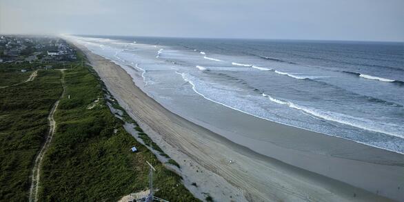
Our shorelines are constantly changing due to waves, storms, sea level rise, and human activities. These changes can sometimes cause negative impacts, like making your favorite beach disappear or damaging homes and important infrastructure.
Understanding how, where, and what kind of change has occurred over time helps coastal managers plan for the future and make decisions that safeguard coastal communities, local economies, and natural resources.

Digital Shoreline Analysis System (DSAS)
The U.S. Geological Survey (USGS) maintains shoreline positions for the United States from older sources, such as aerial photos and topographic surveys, and contemporary sources like digital elevation models (DEMs) and lidar elevation point cloud data.
It's important to maintain, and make available, records of historical shoreline positions to allow monitoring of change over time, and to identify areas most susceptible to erosion or accretion.
Published USGS shoreline change materials are listed under the Data and Publications tabs. They are also listed by state below.
Digital Shoreline Analysis System (DSAS)
Software used to compute shoreline position rates-of-change.
National Shoreline Change geonarrative
Detailed overview of data sources and shoreline extraction and change analysis.
National
Henderson, R.E., Kratzmann, M.G., Heslin, J. L., Farris, A.S., Himmelstoss, E.A., Bartlett, M.K., Thieler, E.R., Weber, K.M., and Lentz, E.E. (2026). USGS National Shoreline Change - A compilation of published shoreline change rates (1800s-2010s) for the contiguous United States: U.S. Geological Survey data release, https://doi.org/10.5066/P14MTEZ3.
Alabama
Kratzmann, M.G., Farris, A.S., and Weber, K.M., 2026, National Shoreline Change—A GIS compilation of vector shorelines and associated shoreline change data from the 1800s to the 2020s for the coast of Alabama: U.S. Geological Survey data release, https://doi.org/10.5066/P1JE2KSO.
Previous publications
Himmelstoss, E.A., Kratzmann, M.G., and Thieler, E.R., 2017, National assessment of shoreline change – A GIS compilation of updated vector shorelines and associated shoreline change data for the Gulf of Mexico: U.S. Geological Survey data release, https://doi.org/10.5066/F78P5XNK.
Henderson, R.E, Nelson, P. R., Long, J.W., and Smith, C., 2017, Vector shorelines and associated shoreline change rates derived from lidar and aerial imagery for Dauphin Island, Alabama: 1940–2015: U.S. Geological Survey data release, https://doi.org/10.5066/F7T43RB5.
Miller, T.L., Morton, R.A., Sallenger, A.H., Moore, L.J., 2004, The National Assessment of Shoreline Change: A GIS Compilation of Vector Shorelines and Associated Shoreline Change Data for the U.S. Gulf of Mexico: USGS Open File Report 2004-1089, https://doi.org/10.3133/ofr20041089.
Alaska
Gibbs, A.E., Snyder, A.G., and Nieminski, N.M., 2026, National Assessment of Shoreline Change: A GIS compilation of updated vector shorelines (1949 to 2015) and associated shoreline change data for the west coast of Alaska, Cape Prince of Wales to Kotlik River: U.S. Geological Survey data release, https://doi.org/10.5066/P1RYHDR7.
Snyder, A.G., and Gibbs, A.E., 2019, National assessment of shoreline change: A GIS compilation of updated vector shorelines and associated shoreline change data for the north coast of Alaska, Icy Cape to Cape Prince of Wales: U.S. Geological Survey data release, https://doi.org/10.5066/P9H1S1PV.
Gibbs, A.E., Ohman, K.A., Coppersmith, R., and Richmond, B.M., 2017, National Assessment of Shoreline Change: A GIS compilation of updated vector shorelines and associated shoreline change data for the north coast of Alaska, U.S. Canadian border to Icy Cape (ver. 2.0, September 2024): U.S. Geological Survey data release, https://doi.org/10.5066/F72Z13N1.
Previous publications
Gibbs, A.E., Ohman, K.A., and Richmond, B.M., 2015, National assessment of shoreline change—A GIS compilation of vector shorelines and associated shoreline change data for the north coast of Alaska, U.S.-Canadian border to Icy Cape: U.S. Geological Survey Open-File Report 2015-1030, https://doi.org/10.3133/ofr20151030.
California
Kratzmann, M.G., Farris, A.S., and Himmelstoss, E.A., 2024, National Shoreline Change—A GIS compilation of vector shorelines and associated shoreline change data from the 1800s to 2010s for the coast of California: U.S. Geological Survey data release, https://doi.org/10.5066/P94J0K7Z.
Barnard, P.L., Smith, S.A., and Foxgrover, A.C., 2020, California shorelines and shoreline change data, 1998-2016: U.S. Geological Survey data release, https://doi.org/10.5066/P91QSGXF.
Previous publications
Hapke, C., and Reid, D., 2006, The National Assessment of Shoreline Change — A GIS Compilation of Vector Shorelines and Associated Shoreline Change Data for the Sandy Shorelines of the California Coast: U.S. Geological Survey Open-File Report 2006–1251, https://doi.org/10.3133/ofr20061251.
Connecticut
Henderson, R.E., Kratzmann, M.G., Farris, A.S., Lentz, E.E., and Himmelstoss, E.A., 2025, National Shoreline Change—A GIS compilation of vector shorelines and associated shoreline change data from the 1800s to the 2010s for the coast of Long Island Sound, New York and Connecticut: U.S. Geological Survey data release, https://doi.org/10.5066/P1TKEDFX.
Delaware
Himmelstoss, E.A., Kratzmann, M., Hapke, C., Thieler, E.R., and List, J., 2010, The national assessment of shoreline change: A GIS compilation of vector shorelines and associated shoreline change data for the New England and Mid-Atlantic Coasts: U.S. Geological Survey Open-File Report 2010–1119, https://doi.org/10.3133/ofr20101119.
Florida
Kratzmann, M.G., Farris, A.S., Weber, K.M., Henderson, R.E., and Himmelstoss, E.A., 2021, USGS National Shoreline Change: A GIS compilation of Updated Vector Shorelines (1800s - 2010s) and Associated Shoreline Change Data for the Georgia and Florida Coasts: U.S. Geological Survey data release, https://doi.org/10.5066/P9J3CVN4.
Previous publications
Kratzmann, M.G., Himmelstoss, E.A., and Thieler, E.R., 2017, National assessment of shoreline change – A GIS compilation of updated vector shorelines and associated shoreline change data for the Southeast Atlantic Coast: U.S. Geological Survey data release, https://doi.org/10.5066/F74X55X7.
Himmelstoss, E.A., Kratzmann, M.G., and Thieler, E.R., 2017, National assessment of shoreline change – A GIS compilation of updated vector shorelines and associated shoreline change data for the Gulf of Mexico: U.S. Geological Survey data release, https://doi.org/10.5066/F78P5XNK.
Miller, T.L., Morton, R.A., Sallenger, A.H., 2005, The National Assessment of Shoreline Change: A GIS Compilation of Vector Shorelines and Associated Shoreline Change Data for the U.S. Southeast Atlantic Coast: U.S. Geological Survey Open-file Report 2005-1326, https://doi.org/10.3133/ofr20051326.
Miller, T.L., Morton, R.A., Sallenger, A.H., Moore, L.J., 2004, The National Assessment of Shoreline Change: A GIS Compilation of Vector Shorelines and Associated Shoreline Change Data for the U.S. Gulf of Mexico: USGS Open File Report 2004-1089, https://doi.org/10.3133/ofr20041089.
Georgia
Kratzmann, M.G., Farris, A.S., Weber, K.M., Henderson, R.E., and Himmelstoss, E.A., 2021, USGS National Shoreline Change: A GIS compilation of Updated Vector Shorelines (1800s - 2010s) and Associated Shoreline Change Data for the Georgia and Florida Coasts: U.S. Geological Survey data release, https://doi.org/10.5066/P9J3CVN4.
Previous publications
Kratzmann, M.G., Himmelstoss, E.A., and Thieler, E.R., 2017, National assessment of shoreline change – A GIS compilation of updated vector shorelines and associated shoreline change data for the Southeast Atlantic Coast: U.S. Geological Survey data release, https://doi.org/10.5066/F74X55X7.
Miller, T.L., Morton, R.A., Sallenger, A.H., 2005, The National Assessment of Shoreline Change: A GIS Compilation of Vector Shorelines and Associated Shoreline Change Data for the U.S. Southeast Atlantic Coast: U.S. Geological Survey Open-file Report 2005-1326, https://doi.org/10.3133/ofr20051326.
Hawaii
Romine, B.M., Fletcher, C.H., Genz, A.S., Barbee, M.M., Dyer, Matthew, Anderson, T.R., Lim, S.C., Vitousek, Sean, Bochicchio, Christopher, and Richmond, B.M., 2012, National Assessment of Shoreline Change: A GIS compilation of vector shorelines and associated shoreline change data for the sandy shorelines of Kauai, Oahu, and Maui, Hawaii: U.S. Geological Survey Open-File Report 2011-1009, available online at https://doi.org/10.3133/ofr20111009.
Louisiana
Himmelstoss, E.A., Kratzmann, M.G., and Thieler, E.R., 2017, National assessment of shoreline change – A GIS compilation of updated vector shorelines and associated shoreline change data for the Gulf of Mexico coast: U.S. Geological Survey data release, https://doi.org/10.5066/F78P5XNK.
Previous publications
Miller, T.L., Morton, R.A., Sallenger, A.H., Moore, L.J., 2004, The National Assessment of Shoreline Change: A GIS Compilation of Vector Shorelines and Associated Shoreline Change Data for the U.S. Gulf of Mexico: USGS Open File Report 2004-1089, https://doi.org/10.3133/ofr20041089.
Maine
Himmelstoss, E.A., Kratzmann, M., Hapke, C., Thieler, E.R., and List, J., 2010, The national assessment of shoreline change: A GIS compilation of vector shorelines and associated shoreline change data for the New England and Mid-Atlantic Coasts: U.S. Geological Survey Open-File Report 2010–1119, https://doi.org/10.3133/ofr20101119.
Maryland
Himmelstoss, E.A., Kratzmann, M., Hapke, C., Thieler, E.R., and List, J., 2010, The national assessment of shoreline change: A GIS compilation of vector shorelines and associated shoreline change data for the New England and Mid-Atlantic Coasts: U.S. Geological Survey Open-File Report 2010–1119, https://doi.org/10.3133/ofr20101119.
Massachusetts
Bartlett, M.K., Henderson, R.E., Farris, A.S., and Himmelstoss, E.A., 2021, Massachusetts shoreline change project, 2021 update - A GIS compilation of shoreline change rates calculated using Digital Shoreline Analysis System version 5.1, with supplementary intersects and baselines for Massachusetts: U.S. Geological Survey data release, https://doi.org/10.5066/P9YGIYFX.
Bartlett, M.K., Farris, A.S., Weber, K.M., and Himmelstoss, E.A., 2021, Massachusetts shoreline change project—A GIS compilation of vector shorelines (1844-2014): U.S. Geological Survey data release, https://doi.org/10.5066/P9O8QA8N.
Previous publications
Himmelstoss, E.A., Farris, A.S., Weber, K.M., and Henderson, R.E., 2019, Massachusetts shoreline change project, 2018 update–A GIS compilation of shoreline change rates calculated using Digital Shoreline Analysis System version 5.0, with supplementary intersects and baselines for Massachusetts (ver. 2.0, August 2019): U.S. Geological Survey data release, https://doi.org/10.5066/P9RRBEYK.
Himmelstoss, E.A., Farris, A.S., and Weber, K.M., 2018, Massachusetts shoreline change project: A GIS compilation of vector shorelines for the 2018 update: U.S. Geological Survey data release, https://doi.org/10.5066/P9O7S72B.
Smith, T.L., Himmelstoss, E.A., and Thieler, E.R., 2013, Massachusetts shoreline change project—A GIS compilation of vector shorelines and associated shoreline change data for the 2013 update: U.S. Geological Survey Open-File Report 2012–1183, https://doi.org/10.3133/ofr20121183.
Himmelstoss, E.A., Kratzmann, M., Hapke, C., Thieler, E.R., and List, J., 2010, The national assessment of shoreline change: A GIS compilation of vector shorelines and associated shoreline change data for the New England and Mid-Atlantic Coasts: U.S. Geological Survey Open-File Report 2010–1119, https://doi.org/10.3133/ofr20101119.
Mississippi
Himmelstoss, E.A., Kratzmann, M.G., and Thieler, E.R., 2017, National assessment of shoreline change – A GIS compilation of updated vector shorelines and associated shoreline change data for the Gulf of Mexico coast: U.S. Geological Survey data release, https://doi.org/10.5066/F78P5XNK.
Previous publications
Miller, T.L., Morton, R.A., Sallenger, A.H., Moore, L.J., 2004, The National Assessment of Shoreline Change: A GIS Compilation of Vector Shorelines and Associated Shoreline Change Data for the U.S. Gulf of Mexico: USGS Open File Report 2004-1089, https://doi.org/10.3133/ofr20041089.
New Hampshire
Himmelstoss, E.A., Kratzmann, M., Hapke, C., Thieler, E.R., and List, J., 2010, The national assessment of shoreline change: A GIS compilation of vector shorelines and associated shoreline change data for the New England and Mid-Atlantic Coasts: U.S. Geological Survey Open-File Report 2010–1119, https://doi.org/10.3133/ofr20101119.
New York
Henderson, R.E., Kratzmann, M.G., Farris, A.S., Lentz, E.E., and Himmelstoss, E.A., 2025, National Shoreline Change—A GIS compilation of vector shorelines and associated shoreline change data from the 1800s to the 2010s for the coast of Long Island Sound, New York and Connecticut: U.S. Geological Survey data release, https://doi.org/10.5066/P1TKEDFX.
Henderson, R.E., Hapke, C.J., Brenner, O.T., and Reynolds, B.J., 2017, Hurricane Sandy beach response and recovery at Fire Island, New York: shoreline, beach profile data, and breach shoreline data—October 2012 to September 2016: U.S. Geological Survey data release, https://doi.org/10.5066/F7G15Z17.
Himmelstoss, E.A., Kratzmann, M., Hapke, C., Thieler, E.R., and List, J., 2010, The national assessment of shoreline change: A GIS compilation of vector shorelines and associated shoreline change data for the New England and Mid-Atlantic Coasts: U.S. Geological Survey Open-File Report 2010–1119, https://doi.org/10.3133/ofr20101119.
North Carolina
Bartlett, M.K., Farris, A.S., Weber, K.M., and Henderson, R.E., 2023, USGS National Shoreline Change — 2017 lidar-derived mean high water shoreline and associated shoreline change data for coastal North Carolina: U.S. Geological Survey data release, https://doi.org/10.5066/P9HYNUNV.
Previous publications
Kratzmann, M.G., Himmelstoss, E.A., and Thieler, E.R., 2017, National assessment of shoreline change – A GIS compilation of updated vector shorelines and associated shoreline change data for the Southeast Atlantic Coast: U.S. Geological Survey data release, https://doi.org/10.5066/F74X55X7.
Miller, T.L., Morton, R.A., Sallenger, A.H., 2005, The National Assessment of Shoreline Change: A GIS Compilation of Vector Shorelines and Associated Shoreline Change Data for the U.S. Southeast Atlantic Coast: U.S. Geological Survey Open-file Report 2005-1326, https://doi.org/10.3133/ofr20051326.
Oregon
Kratzmann, M., Himmelstoss, E.A., Ruggiero, Peter, Thieler, E.R., and Reid, David, 2013, The National assessment of shoreline change—A GIS compilation of vector shorelines and associated shoreline change data for the Pacific Northwest coast: U.S. Geological Survey Open-File Report 2012–1008, https://doi.org/10.3133/ofr20121008.
Puerto Rico
Henderson, R.E., Heslin, J.L., and Himmelstoss, E.A., 2021, Puerto Rico shoreline change — A GIS compilation of shorelines, baselines, intersects, and change rates calculated using the Digital Shoreline Analysis system version 5.1 (ver. 2.0, March 2023): U.S. Geological Survey data release, https://doi.org/10.5066/P9FNRRN0.
Heslin, J.L., Henderson, R.E., and Himmelstoss, E.A., 2021, Historical shorelines for Puerto Rico from 1901 to 1987: U.S. Geological Survey data release, https://doi.org/10.5066/P9CLXCEG.
Heslin, J.L., Henderson, R.E., and Himmelstoss, E.A., 2021, A GIS compilation of vector shorelines for Puerto Rico from 2015 to 2018: U.S. Geological Survey data release, https://doi.org/10.5066/P9AZYW74.
Bracero-Marrero, L., Barreto-Orta, M., Hernández-Montcourt, N., Maldonado-González, R., Himmelstoss, E.A., and Heslin, J.L., 2021, A GIS compilation of vector shorelines and shoreline classification for Puerto Rico from 1970 and 2010: U.S. Geological Survey data release, https://doi.org/10.5066/P9SEUAHC.
Rhode Island
Himmelstoss, E.A., Kratzmann, M., Hapke, C., Thieler, E.R., and List, J., 2010, The national assessment of shoreline change: A GIS compilation of vector shorelines and associated shoreline change data for the New England and Mid-Atlantic Coasts: U.S. Geological Survey Open-File Report 2010–1119, https://doi.org/10.3133/ofr20101119.
South Carolina
Bartlett, M.K., Farris, A.S., and Weber, K.M., 2023, USGS National Shoreline Change - A GIS compilation of new lidar-derived shorelines (2010, 2017, and 2018) and associated shoreline change data for coastal South Carolina: U.S. Geological Survey data release, https://doi.org/10.5066/P9LLAZYE.
Previous publications
Kratzmann, M.G., Himmelstoss, E.A., and Thieler, E.R., 2017, National assessment of shoreline change – A GIS compilation of updated vector shorelines and associated shoreline change data for the Southeast Atlantic Coast: U.S. Geological Survey data release, https://doi.org/10.5066/F74X55X7.
Miller, T.L., Morton, R.A., Sallenger, A.H., 2005, The National Assessment of Shoreline Change: A GIS Compilation of Vector Shorelines and Associated Shoreline Change Data for the U.S. Southeast Atlantic Coast: U.S. Geological Survey Open-file Report 2005-1326, https://doi.org/10.3133/ofr20051326.
Texas
Himmelstoss, E.A., Kratzmann, M.G., and Thieler, E.R., 2017, National assessment of shoreline change – A GIS compilation of updated vector shorelines and associated shoreline change data for the Gulf of Mexico coast: U.S. Geological Survey data release, https://doi.org/10.5066/F78P5XNK.
Previous publications
Miller, T.L., Morton, R.A., Sallenger, A.H., Moore, L.J., 2004, The National Assessment of Shoreline Change: A GIS Compilation of Vector Shorelines and Associated Shoreline Change Data for the U.S. Gulf of Mexico: USGS Open File Report 2004-1089, https://doi.org/10.3133/ofr20041089.
Virginia
Bartlett, M.K., Henderson, R.E., and Farris, A.S., 2023, USGS National Shoreline Change—A GIS compilation of vector shorelines and associated shoreline change data for coastal Virginia from the 1840s to 2010s: U.S. Geological Survey data release, https://doi.org/10.5066/P9DHOFXU.
Previous publications
Himmelstoss, E.A., Kratzmann, M., Hapke, C., Thieler, E.R., and List, J., 2010, The national assessment of shoreline change: A GIS compilation of vector shorelines and associated shoreline change data for the New England and Mid-Atlantic Coasts: U.S. Geological Survey Open-File Report 2010–1119, https://doi.org/10.3133/ofr20101119.
Washington
Kratzmann, M., Himmelstoss, E.A., Ruggiero, Peter, Thieler, E.R., and Reid, David, 2013, The National assessment of shoreline change—A GIS compilation of vector shorelines and associated shoreline change data for the Pacific Northwest coast: U.S. Geological Survey Open-File Report 2012–1008, https://doi.org/10.3133/ofr20121008.
Our shorelines are constantly changing due to waves, storms, sea level rise, and human activities. These changes can sometimes cause negative impacts, like making your favorite beach disappear or damaging homes and important infrastructure.
Understanding how, where, and what kind of change has occurred over time helps coastal managers plan for the future and make decisions that safeguard coastal communities, local economies, and natural resources.