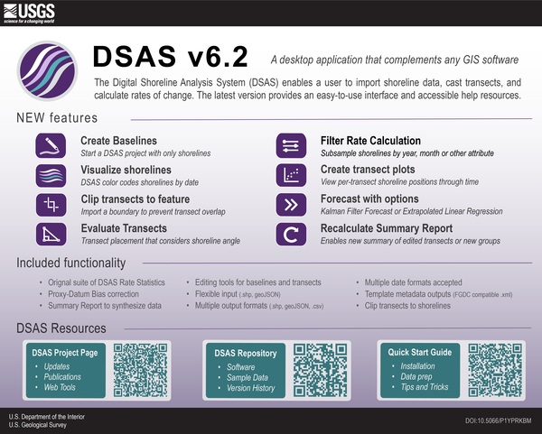
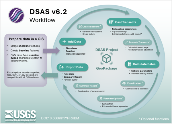
DSAS version 6.2 combines all prior functionality including: regression metrics and distance measurements; FDGC-consistent metadata; a summary report; shoreline forecasting; the application of the proxy-datum bias; data editing options; and enhanced data visualization options.
Rachel Elizabeth Henderson
I conduct research at USGS within the Coastal and Marine Hazards and Resources Program focused on shoreline change - from data collection to the development of software that measures change.
I am a Physical Scientist at the Woods Hole Coastal and Marine Science Center with the U.S. Geological Survey. I oversee projects that define shorelines and measure shoreline change. I am interested in maintaining foundational shoreline datasets that support more complex models of coastal change. My focus recently has been helping migrate the USGS's Digital Shoreline Analysis System software (an application that calculates shoreline or boundary change over time) to a platform agnostic application that can run without the need for a licensed GIS software, supporting the needs of the global user base for change analysis.
Professional Experience
2023 - present, Physical Scientist, USGS Woods Hole Coastal and Marine Science Center
2008- 2023, Research Scientist, Contractor to the USGS, Woods Hole Coastal and Marine Science Center
Education and Certifications
2007, M.S. Environmental Science, Department of Geosciences, University of Rhode Island
2004, B.S. Geology and Environmental Science University of Connecticut
Science and Products
Digital Shoreline Analysis System (DSAS)
Coastal and Marine Science in Long Island Sound
National Shoreline Change Data Publication Catalog
USGS National Shoreline Change - A compilation of published shoreline change rates (1800s-2010s) for the contiguous United States USGS National Shoreline Change - A compilation of published shoreline change rates (1800s-2010s) for the contiguous United States
National Shoreline Change—A GIS compilation of vector shorelines and associated shoreline change data from the 1800s to the 2010s for the coast of Long Island Sound, New York and Connecticut National Shoreline Change—A GIS compilation of vector shorelines and associated shoreline change data from the 1800s to the 2010s for the coast of Long Island Sound, New York and Connecticut
Satellite-derived shorelines from CoastSeg in multiple U.S. locations (1984-2023) Satellite-derived shorelines from CoastSeg in multiple U.S. locations (1984-2023)
Digital Shoreline Analysis System (version 6) Digital Shoreline Analysis System (version 6)
USGS National Shoreline Change - 2017 lidar-derived mean high water shoreline and associated shoreline change data for coastal North Carolina USGS National Shoreline Change - 2017 lidar-derived mean high water shoreline and associated shoreline change data for coastal North Carolina
Assateague Island Seabeach Amaranth Survey Data — 2001 to 2018 Assateague Island Seabeach Amaranth Survey Data — 2001 to 2018
USGS National Shoreline Change - A GIS compilation of new lidar-derived shorelines (2010, 2017, and 2018) and associated shoreline change data for coastal South Carolina USGS National Shoreline Change - A GIS compilation of new lidar-derived shorelines (2010, 2017, and 2018) and associated shoreline change data for coastal South Carolina
USGS National Shoreline Change — A GIS compilation of vector shorelines and associated shoreline change data for coastal Virginia from the 1840s to 2010s USGS National Shoreline Change — A GIS compilation of vector shorelines and associated shoreline change data for coastal Virginia from the 1840s to 2010s
Coastal Change Likelihood in the U.S. Northeast Region: Maine to Virginia Coastal Change Likelihood in the U.S. Northeast Region: Maine to Virginia
Seabeach amaranth presence-absence and barrier island geomorphology metrics as relates to shorebird habitat for Assateague Island National Seashore — 2008, 2010, and 2014 Seabeach amaranth presence-absence and barrier island geomorphology metrics as relates to shorebird habitat for Assateague Island National Seashore — 2008, 2010, and 2014
Puerto Rico shoreline change: A GIS compilation of shorelines, baselines, intersects, and change rates calculated using the Digital Shoreline Analysis system version 5.1 (ver. 2.0, March 2023) Puerto Rico shoreline change: A GIS compilation of shorelines, baselines, intersects, and change rates calculated using the Digital Shoreline Analysis system version 5.1 (ver. 2.0, March 2023)
A GIS Compilation of Vector Shorelines for Puerto Rico from 2015 to 2018 A GIS Compilation of Vector Shorelines for Puerto Rico from 2015 to 2018
Comparisons of shoreline positions from satellite-derived and traditional field- and remote-sensing techniques Comparisons of shoreline positions from satellite-derived and traditional field- and remote-sensing techniques
Assessing decadal-scale coastal change likelihood to define the accuracy and application of scientific information Assessing decadal-scale coastal change likelihood to define the accuracy and application of scientific information
National shoreline change—Summary statistics for vector shorelines from the early 1900s to the 2010s for Puerto Rico National shoreline change—Summary statistics for vector shorelines from the early 1900s to the 2010s for Puerto Rico
Development and application of a coastal change likelihood assessment for the northeast region, Maine to Virginia Development and application of a coastal change likelihood assessment for the northeast region, Maine to Virginia
Digital Shoreline Analysis System (DSAS) version 5.1 user guide Digital Shoreline Analysis System (DSAS) version 5.1 user guide
Forecasting future beach width- A case study along the Florida Atlantic coast Forecasting future beach width- A case study along the Florida Atlantic coast
Digital Shoreline Analysis System (DSAS) version 5.0 user guide Digital Shoreline Analysis System (DSAS) version 5.0 user guide
Assessing the impact of open-ocean and back-barrier shoreline change on Dauphin Island, Alabama, at multiple time scales over the last 75 years Assessing the impact of open-ocean and back-barrier shoreline change on Dauphin Island, Alabama, at multiple time scales over the last 75 years
Characterizing storm response and recovery using the beach change envelope: Fire Island, New York Characterizing storm response and recovery using the beach change envelope: Fire Island, New York
UAS-SfM for coastal research: Geomorphic feature extraction and land cover classification from high-resolution elevation and optical imagery UAS-SfM for coastal research: Geomorphic feature extraction and land cover classification from high-resolution elevation and optical imagery
Morphologic evolution of the wilderness area breach at Fire Island, New York—2012–15 Morphologic evolution of the wilderness area breach at Fire Island, New York—2012–15
Coastal bathymetry data collected in May 2015 from Fire Island, New York—Wilderness breach and shoreface Coastal bathymetry data collected in May 2015 from Fire Island, New York—Wilderness breach and shoreface
Digital Shoreline Analysis System version 6.2 Digital Shoreline Analysis System version 6.2
Digital Shoreline Analysis System version 6.1 Digital Shoreline Analysis System version 6.1
Digital Shoreline Analysis System (version 6) Digital Shoreline Analysis System (version 6)
Digital Shoreline Analysis System Digital Shoreline Analysis System
DSAS version 6.2 combines all prior functionality including: regression metrics and distance measurements; FDGC-consistent metadata; a summary report; shoreline forecasting; the application of the proxy-datum bias; data editing options; and enhanced data visualization options.