Aerial image of Mallard Pond Waterfowl Protection Area
Aerial image of Mallard Pond Waterfowl Protection AreaAerial image of Mallard Pond Waterfowl Protection Area

Official websites use .gov
A .gov website belongs to an official government organization in the United States.
Secure .gov websites use HTTPS
A lock () or https:// means you’ve safely connected to the .gov website. Share sensitive information only on official, secure websites.
Some collected images in Wyoming and Montana.

Aerial image of Mallard Pond Waterfowl Protection Area
Aerial image of Mallard Pond Waterfowl Protection Area

Aerial image of oil facilities

Aerial image of farmed wetland

Aerial image of Long Lake Waterfowl Protection Area

Well sampled to determine baseline pesticide concentrations in groundwater.
Well sampled to determine baseline pesticide concentrations in groundwater.

Location of Smith River watershed, Montana

Drilling a 940 foot deep test well near White Sulphur Springs, Montana
Drilling a 940 foot deep test well near White Sulphur Springs, Montana

Researchers stand at the edge of a saline soil bare patch, Medicine Lake NWR.
Researchers stand at the edge of a saline soil bare patch, Medicine Lake NWR.

Leaking oil line.

Researchers stand in saline soil, Medicine Lake NWR.
Researchers stand in saline soil, Medicine Lake NWR.

Broken oil pipline.

Researchers at Medicine Lake National Wildlife Refuge (MLNWR)
Researchers at Medicine Lake National Wildlife Refuge (MLNWR)

Measuring streamflow in Fish Creek with large Cladophora growth
Measuring streamflow in Fish Creek with large Cladophora growth

Measuring bridge scour in Montana
Measuring bridge scour in Montana

Fish Creek, Wyoming

USGS scientist checking in at USGS Streamgage 13013650 on the Snake River at Moose, Wyoming
USGS scientist checking in at USGS Streamgage 13013650 on the Snake River at Moose, Wyoming
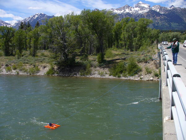
USGS Hydrologist measuring on the Snake River near Moose, Wyoming at Streamgage 13013650
USGS Hydrologist measuring on the Snake River near Moose, Wyoming at Streamgage 13013650

Bridge at USGS streamgage 06177000 during winter with ice over on the Missouri River
Bridge at USGS streamgage 06177000 during winter with ice over on the Missouri River

Measuring bridge scour on Clark Fork River near Superior, MT (April 4, 2007)
Measuring bridge scour on Clark Fork River near Superior, MT (April 4, 2007)

The white stone outcrop is the Tongue River Formation. Photo taken north of Lame Deer, Montana.
The white stone outcrop is the Tongue River Formation. Photo taken north of Lame Deer, Montana.

Clinker is formed whn rock units that overlie exposed burning coal seams are baked and fused. The red clinker is more resistant to erosion than non-baked adjacent Fort Union Formation sandstone and forms the caps of many plateaus and buttes.
Clinker is formed whn rock units that overlie exposed burning coal seams are baked and fused. The red clinker is more resistant to erosion than non-baked adjacent Fort Union Formation sandstone and forms the caps of many plateaus and buttes.