
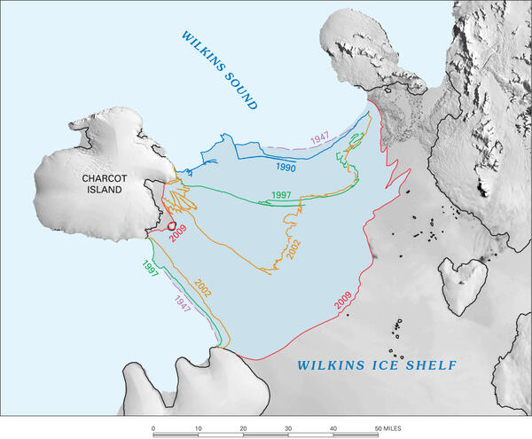
This image shows ice-front retreat in part of the southern Antarctic Peninsula from 1947 to 2009. USGS scientists are studying coastal and glacier change along the entire Antarctic coastline.
Images
Images
Filter Total Items: 9454
Southern Antarctic Peninsula
This image shows ice-front retreat in part of the southern Antarctic Peninsula from 1947 to 2009. USGS scientists are studying coastal and glacier change along the entire Antarctic coastline.

Northern Pintail Duck
A northern pintail duck wearing a transmitter.
A northern pintail duck wearing a transmitter.

Northern Pintail Duck
A male northern pintail duck.
A male northern pintail duck.

California Condor
California condors are one of the most endangered birds in North America. In the early 1990s, captive-bred condors were reintroduced into the wild in California. As of January 2010, about 190 condors now live in the wild and more reintroductions are being considered.
California condors are one of the most endangered birds in North America. In the early 1990s, captive-bred condors were reintroduced into the wild in California. As of January 2010, about 190 condors now live in the wild and more reintroductions are being considered.

Greater Sage-Grouse
Sage-grouse have declined throughout their entire range, largely due to the loss and fragmentation of sagebrush habitat.
Sage-grouse have declined throughout their entire range, largely due to the loss and fragmentation of sagebrush habitat.

A Clay-Colored Sparrow Nest
A colorful clay-colored sparrow nest. These sparrows live in brushy grasslands and prairie habitats.
A colorful clay-colored sparrow nest. These sparrows live in brushy grasslands and prairie habitats.

Elk in Northwestern Wyoming
Elk congregate on the Camp Creek Feed Ground in northwestern Wyoming.
Elk congregate on the Camp Creek Feed Ground in northwestern Wyoming.

Floodwater at Wild Rice River
USGS personnel at work using acoustic doppler on bridge over Wild Rice River. Photo taken at 174th Ave and 124th St southwest of Horace, ND.
USGS personnel at work using acoustic doppler on bridge over Wild Rice River. Photo taken at 174th Ave and 124th St southwest of Horace, ND.

Floodwater at Wild Rice River
Acoustic doppler used to record measurements on Wild Rice River during 2010 flood. Photo taken from bridge at 174th Ave and 124th St southwest of Horace, ND.
Acoustic doppler used to record measurements on Wild Rice River during 2010 flood. Photo taken from bridge at 174th Ave and 124th St southwest of Horace, ND.

Floodwater at Wild Rice River
USGS personnel at work using acoustic doppler on bridge over Wild Rice River. Photo taken at 174th Ave and 124th St southwest of Horace, ND.
USGS personnel at work using acoustic doppler on bridge over Wild Rice River. Photo taken at 174th Ave and 124th St southwest of Horace, ND.

Floodwater at Wild Rice River
USGS personnel at work on bridge over Wild Rice River. Photo taken at 174th Ave and 124th St southwest of Horace, ND.
USGS personnel at work on bridge over Wild Rice River. Photo taken at 174th Ave and 124th St southwest of Horace, ND.

Floodwater at Wild Rice River
USGS personnel at work on bridge over Wild Rice River. Photo taken at 174th Ave and 124th St southwest of Horace, ND.
USGS personnel at work on bridge over Wild Rice River. Photo taken at 174th Ave and 124th St southwest of Horace, ND.

Earthquake-Ready High Rise in Chile
A well-engineered high rise apartment and two-story building in Talca, Chile suffered no evident damage, though much of the city was affected by the M 8.8 earthquake on Feb. 27, 2010. Many buildings in this city were constructed with adobe or masonry and suffered major collapse.
A well-engineered high rise apartment and two-story building in Talca, Chile suffered no evident damage, though much of the city was affected by the M 8.8 earthquake on Feb. 27, 2010. Many buildings in this city were constructed with adobe or masonry and suffered major collapse.

100-Year Old Adobe Building Destroyed
A one hundred year old adobe building in Talca, Chile suffered near-total collapse during the M 8.8 earthquake on Feb. 27, 2010. Adobe, which is made of clay, sand and straw, is no longer used as a building material in Chile, but ancient structures are still common and can pose a hazard to their occupants.
A one hundred year old adobe building in Talca, Chile suffered near-total collapse during the M 8.8 earthquake on Feb. 27, 2010. Adobe, which is made of clay, sand and straw, is no longer used as a building material in Chile, but ancient structures are still common and can pose a hazard to their occupants.

Floodwater at Wild Rice River
USGS personnel at work on bridge over Wild Rice River. Photo taken at 174th Ave and 124th St southwest of Horace, ND.
USGS personnel at work on bridge over Wild Rice River. Photo taken at 174th Ave and 124th St southwest of Horace, ND.

Floodwater at Wild Rice River
Home surrounded by floodwater from Wild Rice River. Photo taken from bridge at 174th Ave and 124th St southwest of Horace, ND.
Home surrounded by floodwater from Wild Rice River. Photo taken from bridge at 174th Ave and 124th St southwest of Horace, ND.

Bighead Carp
Bighead carp are a large and troublesome invasive species from Asia found in the great rivers of the central United States.
Bighead carp are a large and troublesome invasive species from Asia found in the great rivers of the central United States.

Silver Carp
Silver carp are a large a troublesome invasive species from Asia found in the great rivers of the central United States. Silver carp have been observed to jump in response to rocks thrown in the water, passing trains, geese taking off from the water, or just when they unexpectedly find themselves in a tight place.
Silver carp are a large a troublesome invasive species from Asia found in the great rivers of the central United States. Silver carp have been observed to jump in response to rocks thrown in the water, passing trains, geese taking off from the water, or just when they unexpectedly find themselves in a tight place.

Tsunami Carried Boat
The tsunami generated by the M 8.8 earthquake carried many boats onto land - in some cases hundreds of meters inland. The tsunami wave height at this location in Concepcion Harbor (Talcahuano), Chile was about 4-5 meters (12-15 feet).
The tsunami generated by the M 8.8 earthquake carried many boats onto land - in some cases hundreds of meters inland. The tsunami wave height at this location in Concepcion Harbor (Talcahuano), Chile was about 4-5 meters (12-15 feet).

Faces of Port-au-Prince
This photo was taken by USGS seismologist Susan Hough two months after the magnitude-7 earthquake struck Port-au-Prince on Jan. 12, 2010. Dr. Hough traveled to Haiti with USGS colleagues Doug Given, Mark Meremonte, and J. Zebulon Maharrey to install seismometers, which monitor the earth's movement and can detect and measure aftershocks.
This photo was taken by USGS seismologist Susan Hough two months after the magnitude-7 earthquake struck Port-au-Prince on Jan. 12, 2010. Dr. Hough traveled to Haiti with USGS colleagues Doug Given, Mark Meremonte, and J. Zebulon Maharrey to install seismometers, which monitor the earth's movement and can detect and measure aftershocks.

African Rock Python
African rock pythons are the largest snake in Africa, but now some have been found in Florida. They can eat goats, warthogs, and even crocodiles. In Florida, they are an invasive species.
African rock pythons are the largest snake in Africa, but now some have been found in Florida. They can eat goats, warthogs, and even crocodiles. In Florida, they are an invasive species.