
Taken while on a cruise vacation in Bermuda in June 2008.
Images
Images
Filter Total Items: 9454

Jobson's Cove Beach
Taken while on a cruise vacation in Bermuda in June 2008.

Alaska Pipeline
Northslope of Alaska in May

Geologists of Pakistan and USA
Coal Project in Pakistan. Left-Jan Mohammand Mengal; Center-Florian Maldonado; Right-Shahid Khan
Coal Project in Pakistan. Left-Jan Mohammand Mengal; Center-Florian Maldonado; Right-Shahid Khan

Sunset on the River
Looking out over the Georgiana Slough near our floating houseboat used for fish tagging.
Looking out over the Georgiana Slough near our floating houseboat used for fish tagging.

Rouge River National Forest
This picture is taken while climbing Mt. McLoughlin looking east over the Rouge River National Forest and Klamath Lake in Southern Oregon.
This picture is taken while climbing Mt. McLoughlin looking east over the Rouge River National Forest and Klamath Lake in Southern Oregon.

Layers of Ice, Hayden Glacier
This picture was taken from the base of the Hayden Glacier in the Three Sisters Wilderness Area.
This picture was taken from the base of the Hayden Glacier in the Three Sisters Wilderness Area.

Camps Bay Sunset
Sunset over Camps Bay, South Africa
Sunset over Camps Bay, South Africa

Measuring Forest Structure with LiDAR
A LiDAR (Light Detection and Ranging) instrument measures the 3-D structure of a ponderosa pine forest stand in Coconino National Forest near Flagstaff, Arizona, on July 13, 2009.
A LiDAR (Light Detection and Ranging) instrument measures the 3-D structure of a ponderosa pine forest stand in Coconino National Forest near Flagstaff, Arizona, on July 13, 2009.

Prize Staghorn Sculpin of Puget Sound
Collecting samples (sediment, aquatic vegetation, benthic invertebrates, zooplankton, forage fish, and predatory fish) to evaluate δ 15N ratios in the food web within Liberty Bay to evaluate urbanization effects on the nearshore ecosystem. (Coastal Habitats in Puget Sound program).
Collecting samples (sediment, aquatic vegetation, benthic invertebrates, zooplankton, forage fish, and predatory fish) to evaluate δ 15N ratios in the food web within Liberty Bay to evaluate urbanization effects on the nearshore ecosystem. (Coastal Habitats in Puget Sound program).

Matanuska Glacier
Matanuska Glacier, Alaska

Denali Landscape Panorama
Panoramic (~180 degree) view of landscape in Denali National Park, Alaska. Photographed on July 27, 2009, during fieldwork on Dall sheep habitat by members of the USGS Southwest Geographic Science Team.
Panoramic (~180 degree) view of landscape in Denali National Park, Alaska. Photographed on July 27, 2009, during fieldwork on Dall sheep habitat by members of the USGS Southwest Geographic Science Team.

Burning Wetlands
A fire burning over the wetlands in Duson, Louisiana
A fire burning over the wetlands in Duson, Louisiana

Sunrise at Pillar Point
Coast Salish canoe journey preparing to launch; sunrise at Pillar Point. The canoe journey pulled a water quality probe, which measured salinity, temperature, pH, and dissolved oxygen.
Coast Salish canoe journey preparing to launch; sunrise at Pillar Point. The canoe journey pulled a water quality probe, which measured salinity, temperature, pH, and dissolved oxygen.
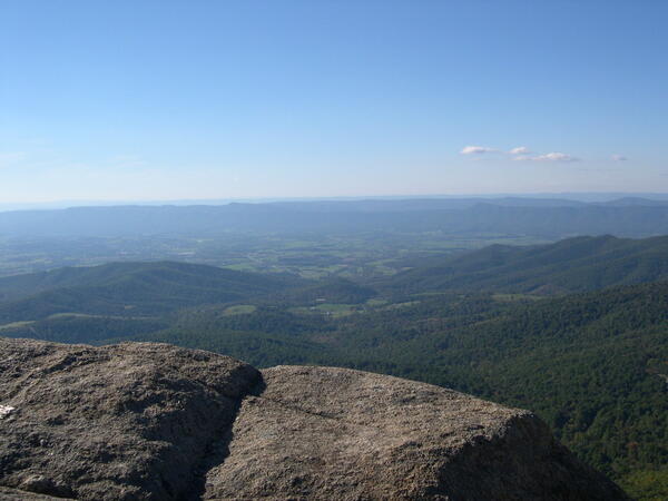
View from Mary's Rock
View from Mary's Rock in Shenandoah National Park, Virginia.
View from Mary's Rock in Shenandoah National Park, Virginia.
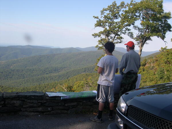
Overlook
John Jones and Jasper look from the overlook for changes in vegetation in Shenandoah National Park, Virginia.
John Jones and Jasper look from the overlook for changes in vegetation in Shenandoah National Park, Virginia.

Sunset Sail at Neah Bay
Coast Salish Canoe Journey 2009, preparation in Neah Bay. The journey pulled a water quality probe to measure salinity, temperature, pH, and dissolved oxygen.
Coast Salish Canoe Journey 2009, preparation in Neah Bay. The journey pulled a water quality probe to measure salinity, temperature, pH, and dissolved oxygen.

Hauling Lampara Net in Skagit Bay
USGS employees attempt to capture forage fish with the use of a Lampara net in Skagit Bay.
USGS employees attempt to capture forage fish with the use of a Lampara net in Skagit Bay.

Sand Hills Gate
The sand hills of Nebraska are a unique ecosystem. The photo was taken to capture the overwhelming vastness of the sand hills. Hecla/Whitman, Nebraska.
The sand hills of Nebraska are a unique ecosystem. The photo was taken to capture the overwhelming vastness of the sand hills. Hecla/Whitman, Nebraska.
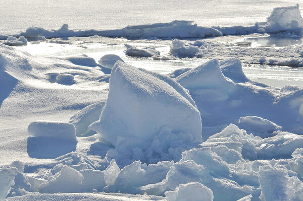
Arctic Ice
The sun shines over the Arctic Ocean Sept. 1, 2009.
The sun shines over the Arctic Ocean Sept. 1, 2009.
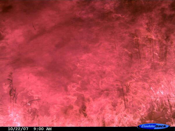
High-Intensity Wildfire Flames
After the photo of the coyote on the run, the next photo on the camera shows high-intensity flames at 9:00 a.m. PST on Oct. 22, 2007. Photo credit: USGS.
After the photo of the coyote on the run, the next photo on the camera shows high-intensity flames at 9:00 a.m. PST on Oct. 22, 2007. Photo credit: USGS.

Northern Pintail Duck
Dr. Hiroyoshi Higuchi (left), Mr. Ken-ichi Tokita (right), and other cooperators from the University of Tokyo, work with USGS scientists to attach a satellite transmitter to the backs of northern pintail ducks on wintering areas of Northern Honshu, Japan.
Dr. Hiroyoshi Higuchi (left), Mr. Ken-ichi Tokita (right), and other cooperators from the University of Tokyo, work with USGS scientists to attach a satellite transmitter to the backs of northern pintail ducks on wintering areas of Northern Honshu, Japan.