
Dead harbor seal found in New England in 2011.
Images
Images
Filter Total Items: 9454

Dead Harbor Seal
Dead harbor seal found in New England in 2011.
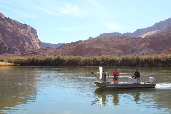
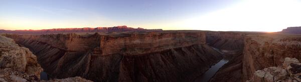
Sampling in the Grand Canyon High Flow Experiment
USGS Aquatic Ecologist Ted Kennedy sampling invertebrate and organic drift at Lees Ferry during the November 19, 2012 HFE.
USGS Aquatic Ecologist Ted Kennedy sampling invertebrate and organic drift at Lees Ferry during the November 19, 2012 HFE.
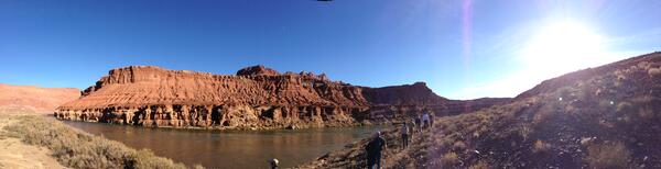
Path Through the Canyon
USGS and BOR staff follow Jack Schmidt on a trail to get a better look at the water level increasing.
USGS and BOR staff follow Jack Schmidt on a trail to get a better look at the water level increasing.
Paria Riffle Field Trip
Downstream from the Paria Riffle, Jack leads a field trip downstream to see the river.
Downstream from the Paria Riffle, Jack leads a field trip downstream to see the river.
Beaver Creek Rapids
USGS Hydrologist David Topping rushes to be the first to look at Beaver Creek Rapids.
USGS Hydrologist David Topping rushes to be the first to look at Beaver Creek Rapids.
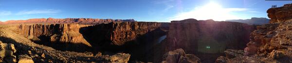
Soap Creek Rapid
Looking downstream at Soap Creek Rapid during sunset.
Looking downstream at Soap Creek Rapid during sunset.
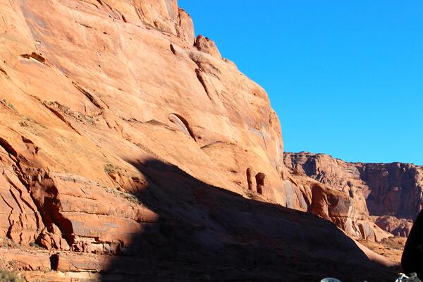
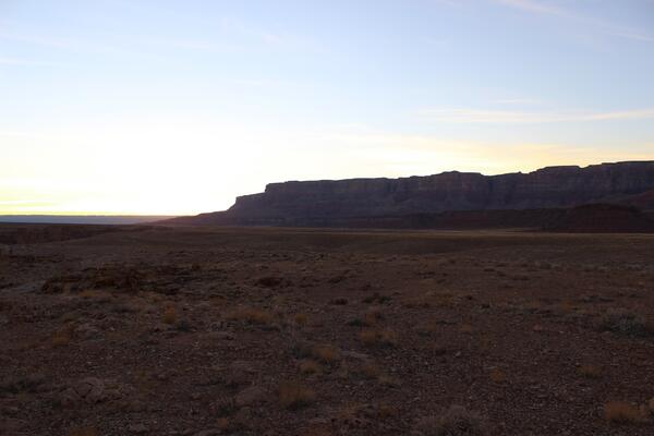
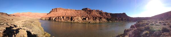
Vermillion Cliffs
A view of the Vermillion Cliffs near Soap Creek Rapid lookout.
A view of the Vermillion Cliffs near Soap Creek Rapid lookout.

Gas Hydrates Research Project in Japan
Scientists from AIST, JOGMEC, Georgia Tech, and the USGS prepare to analyze pressure cores as part of a multi-year gas hydrates research project in Japan. Left to right: Emile Bergeron (USGS), Kiyofumi Suzuki (JOGMEC), Marco Terzariol (Georgia Tech), William Waite (USGS), and Carlos Santamarina (Georgia Tech).
Scientists from AIST, JOGMEC, Georgia Tech, and the USGS prepare to analyze pressure cores as part of a multi-year gas hydrates research project in Japan. Left to right: Emile Bergeron (USGS), Kiyofumi Suzuki (JOGMEC), Marco Terzariol (Georgia Tech), William Waite (USGS), and Carlos Santamarina (Georgia Tech).

Gas Hydrates Research Project in Japan
Scientists from AIST, JOGMEC, Georgia Tech, and the USGS prepare to analyze pressure cores as part of a multi-year gas hydrates research project in Japan. Front to back: Efthymios Papadopoulos (Georgia Tech), William Waite (USGS), and Yoshihiro Konno (AIST) analyze data from sensors inserted into hydrate-bearing pressure cores.
Scientists from AIST, JOGMEC, Georgia Tech, and the USGS prepare to analyze pressure cores as part of a multi-year gas hydrates research project in Japan. Front to back: Efthymios Papadopoulos (Georgia Tech), William Waite (USGS), and Yoshihiro Konno (AIST) analyze data from sensors inserted into hydrate-bearing pressure cores.

Gas Hydrates Research Project in Japan
Scientists from AIST, JOGMEC, Georgia Tech, and the USGS prepare to analyze pressure cores as part of a multi-year gas hydrates research project in Japan. This photo shows the pressure core storage chambers, which contain hydrate-bearing sediment samples obtained from the Nankai Trough offshore Japan.
Scientists from AIST, JOGMEC, Georgia Tech, and the USGS prepare to analyze pressure cores as part of a multi-year gas hydrates research project in Japan. This photo shows the pressure core storage chambers, which contain hydrate-bearing sediment samples obtained from the Nankai Trough offshore Japan.

Gas Hydrates Research Project in Japan
Scientists from AIST, JOGMEC, Georgia Tech, and the USGS prepare to analyze pressure cores as part of a multi-year gas hydrates research project in Japan. Left to right: Efthymios Papadopoulos (Georgia Tech), Yoshihiro Konno (AIST), and William Winters (USGS).
Scientists from AIST, JOGMEC, Georgia Tech, and the USGS prepare to analyze pressure cores as part of a multi-year gas hydrates research project in Japan. Left to right: Efthymios Papadopoulos (Georgia Tech), Yoshihiro Konno (AIST), and William Winters (USGS).

A Record-Breaking Invasive Burmese Python
This female Burmese python broke the records for her length - 17 feet, 7 inches - and the number of eggs she contained: 87. She was first captured in Everglades National Park by USGS researchers in the spring of 2012, when they followed a "Judas snake" - a male python with a transmitter - and found her nearby in the bushes.
This female Burmese python broke the records for her length - 17 feet, 7 inches - and the number of eggs she contained: 87. She was first captured in Everglades National Park by USGS researchers in the spring of 2012, when they followed a "Judas snake" - a male python with a transmitter - and found her nearby in the bushes.

2013 Gas Hydrate Expedition in Gulf of Mexico
USGS technician Jenny White prepares equipment for deployment on the research vessel Pelican during a cruise to explore gas hydrates in the Gulf of Mexico from April to May, 2013.
USGS technician Jenny White prepares equipment for deployment on the research vessel Pelican during a cruise to explore gas hydrates in the Gulf of Mexico from April to May, 2013.

2013 Gas Hydrate Expedition in Gulf of Mexico
USGS co-chief scientist Seth Haines and technician Tom O’Brien work on data acquisition and analysis in the laboratory of the research vessel Pelican during a cruise to explore gas hydrates in the deepwater Gulf of Mexico from April to May, 2013.
USGS co-chief scientist Seth Haines and technician Tom O’Brien work on data acquisition and analysis in the laboratory of the research vessel Pelican during a cruise to explore gas hydrates in the deepwater Gulf of Mexico from April to May, 2013.

2013 Gas Hydrate Expedition in Gulf of Mexico
USGS technician Pete Dal Ferro watches as the generator injector guns (silver), the compressor hose (black), and orange buoys are retrieved from the waters of the Gulf of Mexico during a cruise to image gas hydrates in the Gulf of Mexico from April to May, 2013.
USGS technician Pete Dal Ferro watches as the generator injector guns (silver), the compressor hose (black), and orange buoys are retrieved from the waters of the Gulf of Mexico during a cruise to image gas hydrates in the Gulf of Mexico from April to May, 2013.

Florida Panther
Florida panther rests in it's Southwest Florida habitat.
Florida panther rests in it's Southwest Florida habitat.

Research Vessel Kiyi
The USGS GLSC's R/V Kiyi. The vessel is deployed for field work on Lake Superior between the months of May and November.
The USGS GLSC's R/V Kiyi. The vessel is deployed for field work on Lake Superior between the months of May and November.

Old Chevak Goose Camp
Old Chevak ancestral church reborn as research site in 1986 for 25 year cooperative banding program where Chevak youth worked with U.S. Geological Survey and U.S. Fish and Wildlife Service capturing and banding geese and swans along the Kashunuk River on Yukon-Kuskokwim Delta, Alaska.
Old Chevak ancestral church reborn as research site in 1986 for 25 year cooperative banding program where Chevak youth worked with U.S. Geological Survey and U.S. Fish and Wildlife Service capturing and banding geese and swans along the Kashunuk River on Yukon-Kuskokwim Delta, Alaska.

Swift River Waterfall
This photo was taken at USGS gaging station 01055000 on the Swift River near Roxbury, Maine. The falls is most commonly referred to as Swift River Falls and has many potholes and scours that demonstrate the impressive ability of water to errode rock.
This photo was taken at USGS gaging station 01055000 on the Swift River near Roxbury, Maine. The falls is most commonly referred to as Swift River Falls and has many potholes and scours that demonstrate the impressive ability of water to errode rock.

Mw6.6 Lushan China Earthquake, April 20 2013
Life in a tent. Family members having lunch together.
Life in a tent. Family members having lunch together.