
The Faka Union Canal Weir #1 (Collier County, Florida) helps create a downstream hydrological haven for manatees. During the cold winter months, the right flow conditions can maintain a salinity gradient known as a halocline that traps warm water near the bottom of the residential canals at Port of the Islands.
Images
Images
Filter Total Items: 9454

Faka Union Canal Weir #1, Collier County, Florida
The Faka Union Canal Weir #1 (Collier County, Florida) helps create a downstream hydrological haven for manatees. During the cold winter months, the right flow conditions can maintain a salinity gradient known as a halocline that traps warm water near the bottom of the residential canals at Port of the Islands.

Flow Over Faka Union Canal Weir #1
Freshwater flowing over the Faka Union Canal Weir #1 near Port of the Islands, Collier County, Florida. During cold weather, freshwater flows here can maintain a downstream salinity gradient that creates a warm water refuge for manatees.
Freshwater flowing over the Faka Union Canal Weir #1 near Port of the Islands, Collier County, Florida. During cold weather, freshwater flows here can maintain a downstream salinity gradient that creates a warm water refuge for manatees.

Manatee Swimming in Faka Union Canal, Florida
A manatee swims downstream from a weir in Faka Union Canal known to create a strong salinity gradient downstream.
A manatee swims downstream from a weir in Faka Union Canal known to create a strong salinity gradient downstream.

USGS Technician Constructing Monitoring Station
A USGS technician finishes construction on a monitoring station used to monitor surface salinity and temperature below Faka Union Canal Weir #1, Florida. By measuring hydrologic conditions here, researchers found that freshwater flow rates help maintain warm water pockets in downstream areas of the canal.
A USGS technician finishes construction on a monitoring station used to monitor surface salinity and temperature below Faka Union Canal Weir #1, Florida. By measuring hydrologic conditions here, researchers found that freshwater flow rates help maintain warm water pockets in downstream areas of the canal.
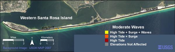
Western Santa Rosa Island moderate waves weather scenario
Western Santa Rosa Island moderate waves weather scenarioWestern Santa Rosa Island moderate waves weather scenario.
Western Santa Rosa Island moderate waves weather scenario
Western Santa Rosa Island moderate waves weather scenarioWestern Santa Rosa Island moderate waves weather scenario.

Harmful Algal Blooms
You may notice a green, red or brown film on your favorite boating or swimming area in the summer. This coloring could mean that the water is affected by harmful algal blooms. Harmful algal blooms are an accumulation of tiny organisms known as algae and can release harmful toxins into the environment. Pictured here is a bloom on the shore of Lake Dora, FL.
You may notice a green, red or brown film on your favorite boating or swimming area in the summer. This coloring could mean that the water is affected by harmful algal blooms. Harmful algal blooms are an accumulation of tiny organisms known as algae and can release harmful toxins into the environment. Pictured here is a bloom on the shore of Lake Dora, FL.

Harmful Algal Blooms
You may notice a green, red or brown film on your favorite boating or swimming area in the summer. This coloring could mean that the water is affected by harmful algal blooms. Harmful algal blooms are an accumulation of tiny organisms known as algae and can release harmful toxins into the environment. Pictured here is Binder Lake in Iowa covered in algal blooms.
You may notice a green, red or brown film on your favorite boating or swimming area in the summer. This coloring could mean that the water is affected by harmful algal blooms. Harmful algal blooms are an accumulation of tiny organisms known as algae and can release harmful toxins into the environment. Pictured here is Binder Lake in Iowa covered in algal blooms.

USGS Sirenia Project Researchers at Work Studying Manatees
USGS Sirenia Project Researchers at Work Studying ManateesUSGS Sirenia Project researchers studying manatees in Florida.
USGS Sirenia Project Researchers at Work Studying Manatees
USGS Sirenia Project Researchers at Work Studying ManateesUSGS Sirenia Project researchers studying manatees in Florida.

Harmful Algal Blooms
You may notice a green, red or brown film on your favorite boating or swimming area in the summer. This coloring could mean that the water is affected by harmful algal blooms. Harmful algal blooms are an accumulation of tiny organisms known as algae and can release harmful toxins into the environment.
You may notice a green, red or brown film on your favorite boating or swimming area in the summer. This coloring could mean that the water is affected by harmful algal blooms. Harmful algal blooms are an accumulation of tiny organisms known as algae and can release harmful toxins into the environment.
Coastal Landslide Caused by the 2010 Haiti Earthquake
Coastal Landslide Caused by the 2010 Haiti EarthquakeEarthquake-triggered landslide on south coast of Haiti near village of Nan Diamant.
Coastal Landslide Caused by the 2010 Haiti Earthquake
Coastal Landslide Caused by the 2010 Haiti EarthquakeEarthquake-triggered landslide on south coast of Haiti near village of Nan Diamant.

Rockfall Caused by the January12, 2010 Haiti Earthquake
Rockfall Caused by the January12, 2010 Haiti EarthquakeBoulders of intact limestone that fell and rolled during the earthquake from cliffs along the Haiti earthquake fault zone.
Rockfall Caused by the January12, 2010 Haiti Earthquake
Rockfall Caused by the January12, 2010 Haiti EarthquakeBoulders of intact limestone that fell and rolled during the earthquake from cliffs along the Haiti earthquake fault zone.

Landslides in Limestone
This photo shows the dense concentration of landslides in limestone near the Haiti earthquake fault zone.
This photo shows the dense concentration of landslides in limestone near the Haiti earthquake fault zone.

Distant Plume from Puhi-o-Kalaikini
The plume from the Puhi-o-Kalaikini ocean entry is easily visible from Highway 130, on the hill descending towards Kalapana. Just in front of the ocean entry plume, the houses of Kalapana Gardens subdivision can be seen on the 1990 lava flows.
The plume from the Puhi-o-Kalaikini ocean entry is easily visible from Highway 130, on the hill descending towards Kalapana. Just in front of the ocean entry plume, the houses of Kalapana Gardens subdivision can be seen on the 1990 lava flows.

Fish Processing in Lab
Technician processes fish samples brought in from mangroves.
Technician processes fish samples brought in from mangroves.

Seining Blocked-off Mosquito Ditch
Scientists pull a seine net through a blocked-off section of a man-made ditch to estimate fish abundance.
Scientists pull a seine net through a blocked-off section of a man-made ditch to estimate fish abundance.

College Student, Laurence Benson, Working on a Weather Station
College Student, Laurence Benson, Working on a Weather StationWeather station site, Shenandoah National Park.
College Student, Laurence Benson, Working on a Weather Station
College Student, Laurence Benson, Working on a Weather StationWeather station site, Shenandoah National Park.

Stream
Stream near Pocosin weather station site, Shenandoah National Park.
Stream near Pocosin weather station site, Shenandoah National Park.

Ice Puzzle
Break up of river, late May in Alaska.
Before the Spill
Gulf of Mexico Near Destin

ARRA-funded Student Sampling Gas at Augustine Volcano
ARRA-funded Student Sampling Gas at Augustine VolcanoARRA-funded student Taryn Lopez (Univ. Alaska-Fairbanks) sampling gas emissions at fumarole next to dome at the summit of Augustine volcano.
ARRA-funded Student Sampling Gas at Augustine Volcano
ARRA-funded Student Sampling Gas at Augustine VolcanoARRA-funded student Taryn Lopez (Univ. Alaska-Fairbanks) sampling gas emissions at fumarole next to dome at the summit of Augustine volcano.

Why We Do What We Do!!!
Schools out !. Bus passing by largest Burr Oak in Missouri.
Schools out !. Bus passing by largest Burr Oak in Missouri.