
Bighead carp are a large and troublesome invasive species from Asia found in the great rivers of the central United States.
Images
Images
Filter Total Items: 9448

Bighead Carp
Bighead carp are a large and troublesome invasive species from Asia found in the great rivers of the central United States.

Interior of Damaged Hospital
The interior of this masonry-built hospital in Cauquenes, Chile had severe fracturing and partially collapsed interior walls following the M 8.8 earthquake on Feb. 27, 2010. This building will be torn down and replaced with a reinforced concrete building.
The interior of this masonry-built hospital in Cauquenes, Chile had severe fracturing and partially collapsed interior walls following the M 8.8 earthquake on Feb. 27, 2010. This building will be torn down and replaced with a reinforced concrete building.

Floodwater at Wild Rice River
Acoustic doppler used to record measurements on Wild Rice River during 2010 flood. Photo taken from bridge at 174th Ave and 124th St southwest of Horace, ND.
Acoustic doppler used to record measurements on Wild Rice River during 2010 flood. Photo taken from bridge at 174th Ave and 124th St southwest of Horace, ND.

Bighead Carp
Bighead carp are a large and troublesome invasive species from Asia found in the great rivers of the central United States.
Bighead carp are a large and troublesome invasive species from Asia found in the great rivers of the central United States.

House and Car Destroyed by Tsunami
A house and a car were destroyed by a tsunami in the coastal city of Dichato, Chile, located about 15 km north of Concepcion, Chile. The tsunami height was about 10 meters (32 feet). Several hundred homes were destroyed in this city as a result of the M 8.8 earthquake on Feb. 27, 2010
A house and a car were destroyed by a tsunami in the coastal city of Dichato, Chile, located about 15 km north of Concepcion, Chile. The tsunami height was about 10 meters (32 feet). Several hundred homes were destroyed in this city as a result of the M 8.8 earthquake on Feb. 27, 2010

Floodwater at Wild Rice River
Acoustic doppler used to record measurements on Wild Rice River during 2010 flood. Photo taken from bridge at 174th Ave and 124th St southwest of Horace, ND.
Acoustic doppler used to record measurements on Wild Rice River during 2010 flood. Photo taken from bridge at 174th Ave and 124th St southwest of Horace, ND.

Tracking Curlews
After being caught by mist nets, birds are anesthetized while a small transmitter is inserted into the abdominal cavity. The surgical procedure takes less than 30 minutes. Birds recover quickly and are ready for release within an hour of surgery. This photo shows a male curlew with a black leg flag inscribed "H8".
After being caught by mist nets, birds are anesthetized while a small transmitter is inserted into the abdominal cavity. The surgical procedure takes less than 30 minutes. Birds recover quickly and are ready for release within an hour of surgery. This photo shows a male curlew with a black leg flag inscribed "H8".

Long-Billed Curlews
The Long-billed Curlew (Numenius americanus) is the largest North American shorebird and is characterized by its long and decurved bill.
The Long-billed Curlew (Numenius americanus) is the largest North American shorebird and is characterized by its long and decurved bill.

Curlew Chick
Curlew Chicks hatch in late June and are almost immediately ready to leave the nest. The coloring and pattern of the downy chicks provides camouflage to protect them from avian and mammalian predators. Chicks follow their parents on long hikes to feeding areas. Curlews also migrate long distances each year.
Curlew Chicks hatch in late June and are almost immediately ready to leave the nest. The coloring and pattern of the downy chicks provides camouflage to protect them from avian and mammalian predators. Chicks follow their parents on long hikes to feeding areas. Curlews also migrate long distances each year.

Brittle Star
A tiny brittle star (the central disc is smaller than a dime) clings to the branches of a soft coral in a sample bucket brought into the shipboard laboratory from a submersible dive. This creature makes its home on the deep, dark ocean floor.
A tiny brittle star (the central disc is smaller than a dime) clings to the branches of a soft coral in a sample bucket brought into the shipboard laboratory from a submersible dive. This creature makes its home on the deep, dark ocean floor.

USGS Installing Seismometers in Haiti
USGS seimologist Doug Given works with colleagues from the Bureau des Mines et de l'Energie to install a seismometer. Seismometers monitor the earth's movement and can detect and measure aftershocks. Given traveled to Haiti with USGS colleagues Susan Hough, Mark Meremonte, and J. Zebulon Maharrey shortly after a magnitude-7 earthquake struck on Jan. 12, 2010.
USGS seimologist Doug Given works with colleagues from the Bureau des Mines et de l'Energie to install a seismometer. Seismometers monitor the earth's movement and can detect and measure aftershocks. Given traveled to Haiti with USGS colleagues Susan Hough, Mark Meremonte, and J. Zebulon Maharrey shortly after a magnitude-7 earthquake struck on Jan. 12, 2010.

USGS Installing Seismometers in Haiti
USGS seismologist Doug Given worked with colleagues from the Bureau des Mines et de l'Energie to install a seismometer. Seismometers monitor the earth's movement and can detect and measure aftershocks. Given traveled to Haiti with USGS colleagues Susan Hough, Mark Meremonte, and J.
USGS seismologist Doug Given worked with colleagues from the Bureau des Mines et de l'Energie to install a seismometer. Seismometers monitor the earth's movement and can detect and measure aftershocks. Given traveled to Haiti with USGS colleagues Susan Hough, Mark Meremonte, and J.

An Endangered Devils Hole Pupfish
A Devils Hole pupfish swims above the algae mat that typically covers the shallow spawning shelf in Devils Hole.
A Devils Hole pupfish swims above the algae mat that typically covers the shallow spawning shelf in Devils Hole.

USGS Researcher Monitoring Endangered Pupfish
USGS Cooperative Research Unit graduate student Ambre Chaudoin monitors pupfish spawning behavior in Devils Hole, the only habitat for endangered Devils Hole pupfish.The USGS cameras that captured effects of an earthquake on Devils Hole can be seen in this picture.
USGS Cooperative Research Unit graduate student Ambre Chaudoin monitors pupfish spawning behavior in Devils Hole, the only habitat for endangered Devils Hole pupfish.The USGS cameras that captured effects of an earthquake on Devils Hole can be seen in this picture.

Port-au-Prince After the Earthquake
High resolution satellite imagery showed the landscape and building damages before and after the magnitude-7 earthquake hit Haiti in the beginning of 2010. This image was taken after the earthquake.
High resolution satellite imagery showed the landscape and building damages before and after the magnitude-7 earthquake hit Haiti in the beginning of 2010. This image was taken after the earthquake.
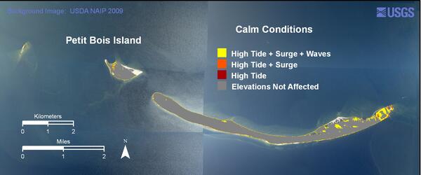
Petit Bois Island calm conditions weather scenario
Petit Bois Island calm conditions weather scenarioPetit Bois Island calm conditions weather scenario.
Petit Bois Island calm conditions weather scenario
Petit Bois Island calm conditions weather scenarioPetit Bois Island calm conditions weather scenario.
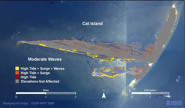
Cat Island moderate waves weather scenario
Cat Island moderate waves weather scenario.
Cat Island moderate waves weather scenario.
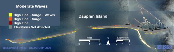
Dauphin Island high moderate weather scenario
Dauphin Island moderate waves weather scenario.
Dauphin Island moderate waves weather scenario.

Aquatic Bacteria Samples
On April 20, 2010, the BP Deepwater Horizon drilling platform collapsed and sank in the Gulf of Mexico, causing one of the largest oil spills in history. One of the big dilemmas in responding to the oil spil is how to clean up the oil itself. One way currently under research is to use bacteria that naturally break down oil.
On April 20, 2010, the BP Deepwater Horizon drilling platform collapsed and sank in the Gulf of Mexico, causing one of the largest oil spills in history. One of the big dilemmas in responding to the oil spil is how to clean up the oil itself. One way currently under research is to use bacteria that naturally break down oil.

Harmful Algal Blooms
You may notice a green, red or brown film on your favorite boating or swimming area in the summer. This coloring could mean that the water is affected by harmful algal blooms. Harmful algal blooms are an accumulation of tiny organisms known as algae and can release harmful toxins into the environment. Pictured here is Binder Lake in Iowa covered in algal blooms.
You may notice a green, red or brown film on your favorite boating or swimming area in the summer. This coloring could mean that the water is affected by harmful algal blooms. Harmful algal blooms are an accumulation of tiny organisms known as algae and can release harmful toxins into the environment. Pictured here is Binder Lake in Iowa covered in algal blooms.