U.S. flag

An official website of the United States government

Multimedia

Browse images and videos related to earthquakes and earthquake hazards.

Images

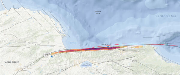
Locations and amount of slip on the Bocono and San Sebastian faults in Venezuela during earthquakes in June, 2026.
Bocono and San Sebastian faults in Venezuela; slip rates from June 2026

Locations and amount of slip on the Bocono and San Sebastian faults in Venezuela during earthquakes in June, 2026. The fault model was generated by Hanagan, C., Reitman, N.G., Barnhart, W.D., and Schmitt, R.
Locations and amount of slip on the Bocono and San Sebastian faults in Venezuela during earthquakes in June, 2026. The fault model was generated by Hanagan, C., Reitman, N.G., Barnhart, W.D., and Schmitt, R.
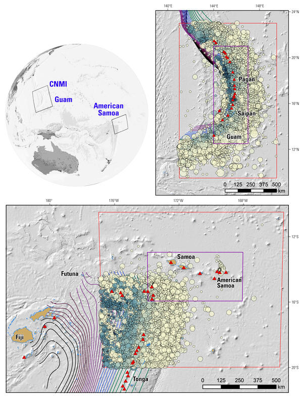
A location map and inset maps of the National Seismic Hazard Model areas of interest for the Pacific Territories.
Map of tectonic setting for NSHM27 of Guam, Northern Mariana Islands, and American Samoa

This location map and inset maps of the National Seismic Hazard Model (NSHM) show areas of interest for the populated Pacific Territories of the United States. The inset maps highlight Guam and the Commonwealth of the Northern Mariana Islands (GNMI) and American Samoa (AmSam), two large regions assessed for seismic hazards in the NSHM of 2027.

This location map and inset maps of the National Seismic Hazard Model (NSHM) show areas of interest for the populated Pacific Territories of the United States. The inset maps highlight Guam and the Commonwealth of the Northern Mariana Islands (GNMI) and American Samoa (AmSam), two large regions assessed for seismic hazards in the NSHM of 2027.

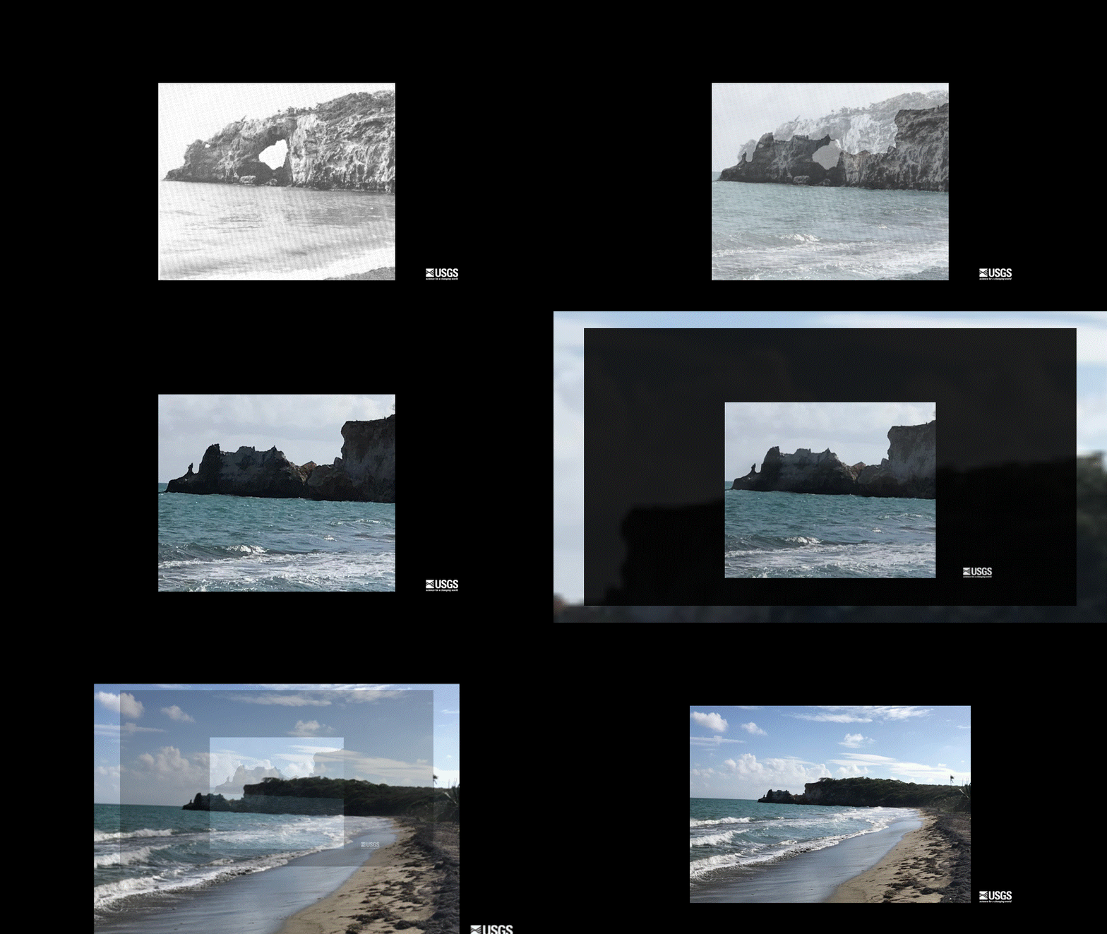
An image sequence to show the collapse of the natural bridge, Punta Ventana, Puerto Rico
Collapsed natural arch of Punta Ventana, Guayanilla, Puerto Rico

The starting view is from January, 1970, a field photo of Punta Ventana (“Window Point”) at Guayanilla, Puerto Rico (Monroe, 1980). The image fades to the March 5, 2020 color photo of the same location (ten Brink, 2020). The natural arch had collapsed from earthquake shaking on January 6, 2020 during the 2020 Southwest Puerto Rico Earthquake Sequence.

The starting view is from January, 1970, a field photo of Punta Ventana (“Window Point”) at Guayanilla, Puerto Rico (Monroe, 1980). The image fades to the March 5, 2020 color photo of the same location (ten Brink, 2020). The natural arch had collapsed from earthquake shaking on January 6, 2020 during the 2020 Southwest Puerto Rico Earthquake Sequence.

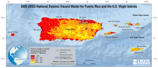
2025 USGS National Seismic Hazard Model for Puerto Rico and U.S. Virgin Islands Chance of Damaging Shaking Map

2025 USGS National Seismic Hazard Model for Puerto Rico and U.S. Virgin Islands Chance of Damaging Shaking Map; chance of slight-or-greater damaging earthquake shaking in 100 years (equivalent to Modified Mercalli Intensity VI).

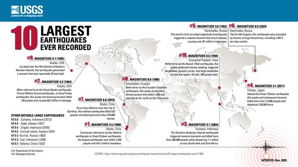
10 Largest Earthquakes Ever Recorded
10 Largest Earthquakes Ever Recorded (Updated 2025)

10 Largest Earthquakes Ever Recorded (Updated 2025)

#10. MAGNITUDE 8.6 (1950). Arunachal Pradesh, India - Referred to as the Assam-Tibet earthquake, this quake produced intense shaking, triggered sandblows, ground cracks, and large landslides across the region. All told, 780 people died.

10 Largest Earthquakes Ever Recorded (Updated 2025)

#10. MAGNITUDE 8.6 (1950). Arunachal Pradesh, India - Referred to as the Assam-Tibet earthquake, this quake produced intense shaking, triggered sandblows, ground cracks, and large landslides across the region. All told, 780 people died.

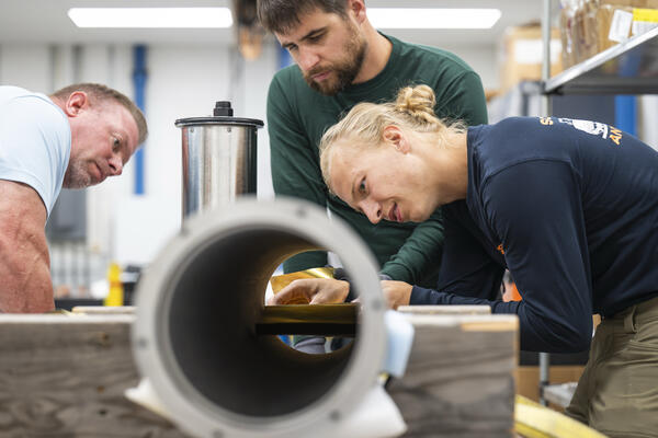
Assembling a seismometer at the Physical Sciences Laboratory in Stoughton.
IceCube 2025-08-07TW 0407

Jason Patton, Rob Anthony (USGS), and Skyler Grulke assemble a seismometer at the Physical Sciences Laboratory in Stoughton, Wisconsin on Aug. 7, 2025. (Photo by Taylor Wolfram / UW–Madison)

Jason Patton, Rob Anthony (USGS), and Skyler Grulke assemble a seismometer at the Physical Sciences Laboratory in Stoughton, Wisconsin on Aug. 7, 2025. (Photo by Taylor Wolfram / UW–Madison)

Videos

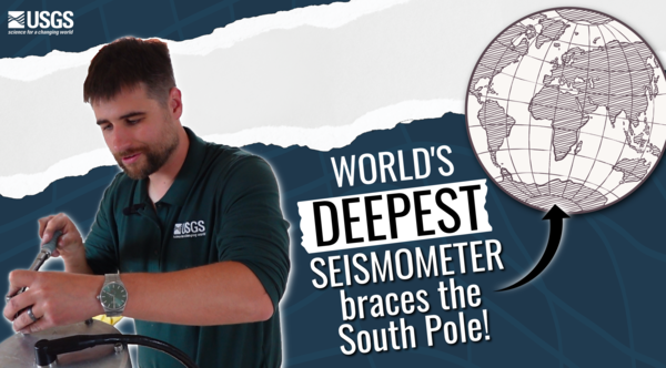
Deep Ice Seismometer Thumbnail Deep Ice Seismometer Thumbnail
World's deepest seismometer braces the South Pole!

Get ready to journey to the bottom of the world! The Deep Ice Seismometer is a groundbreaking new tool that will revolutionize how we monitor earthquakes across the globe. Developed through a powerful collaboration between the U.S.

Get ready to journey to the bottom of the world! The Deep Ice Seismometer is a groundbreaking new tool that will revolutionize how we monitor earthquakes across the globe. Developed through a powerful collaboration between the U.S.

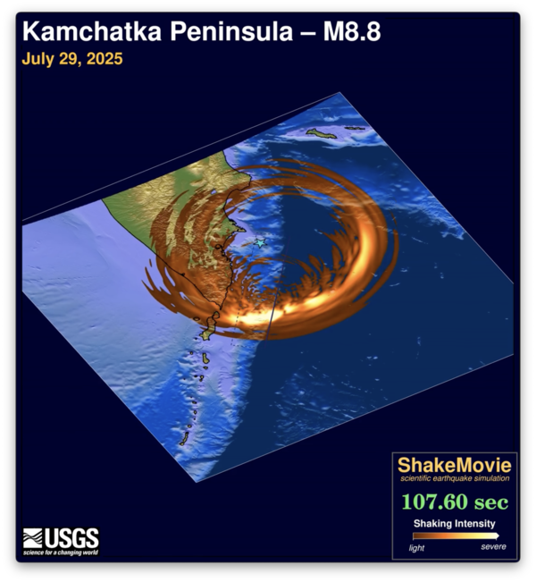
seismic waves emanating from M8.8 Russia quake seismic waves emanating from M8.8 Russia quake
M 8.8 Kamchatka Peninsula Earthquake ShakeMovie

Shakemovie animation showing seismic waves emanating from the magnitude 8.8 Kamchatka Peninsula earthquake.

Shake Movie for M5.2 Julian earthquake Thumbnail Shake Movie for M5.2 Julian earthquake Thumbnail
Shake Movie for M5.2 Julian earthquake

Computer simulation of shaking during the April 14, 2025 M5.2 Julian, CA earthquake. As the waves propagate away from the epicenter they interact with different geologic materials, which can slow down and amplify the shaking.

Computer simulation of shaking during the April 14, 2025 M5.2 Julian, CA earthquake. As the waves propagate away from the epicenter they interact with different geologic materials, which can slow down and amplify the shaking.

man in front of a graphic for PAGER man in front of a graphic for PAGER
USGS PAGER during the Magnitude 7.7 2025 Mandalay, Burma (Myanmar) Earthquake

Dr. William Yeck is a seismologist with the USGS National Earthquake Information Center. He explains the importance of PAGER during the magnitude 7.7 2025 Mandalay, Burma (Myanmar) Earthquake.

cartoon image of ammonia (NH3) and ammonium (NH4+) cartoon image of ammonia (NH3) and ammonium (NH4+)
Ammonia or Ammonium? What’s the difference?

Ammonia or ammonium? What’s the difference? In water, ammonia (NH3) and ammonium (NH4+) exist together in an equilibrium that depends on pH and temperature. As the temperature or pH rise, ammonia (NH3) becomes more abundant. This is important because ammonia is more toxic than ammonium.

Ammonia or ammonium? What’s the difference? In water, ammonia (NH3) and ammonium (NH4+) exist together in an equilibrium that depends on pH and temperature. As the temperature or pH rise, ammonia (NH3) becomes more abundant. This is important because ammonia is more toxic than ammonium.

Explained: The December 5th, 2024 Earthquake

USGS Scientist, Bob deGroot, briefly explains what happened during the magnitude 7.0 earthquake that occurred offshore of Mendocino, CA, on December 5, 2024.

The event occurred in an area called the Triple Junction, where the Pacific, Juan de Fuca, and North American tectonic plates meet.

USGS Scientist, Bob deGroot, briefly explains what happened during the magnitude 7.0 earthquake that occurred offshore of Mendocino, CA, on December 5, 2024.

The event occurred in an area called the Triple Junction, where the Pacific, Juan de Fuca, and North American tectonic plates meet.

Audio

Landers rupture
Landers rupture
Landers rupture
Landers Rupture — Sue on what we've learned since
Landers rupture
Landers rupture
Landers rupture
Landers Rupture — Where they were
Landers rupture
Landers rupture
Landers rupture
Landers Rupture — Where they were

USGS scientists remember where they were during the 1992 Landers earthquake in Southern California

Landers rupture
Landers rupture
Landers rupture
Landers Rupture — Sue on what it felt like
Landers rupture
Landers rupture
Landers rupture
Landers Rupture — Sue on what it felt like

USGS seismologist Susan Hough recalls what the 1992 Landers earthquake felt like from Pasadena, CA. 

Landers rupture
Landers rupture
Landers rupture
Landers Rupture — Jonathan Fieldwork
Landers rupture
Landers rupture
Landers rupture
Landers Rupture — Jonathan Fieldwork

USGS geologist Jonathan Matti recalls fieldwork in the Mojave Desert soon after the 1992 Landers earthquake. 

USGS geologist Jonathan Matti recalls fieldwork in the Mojave Desert soon after the 1992 Landers earthquake. 

Landers rupture
Landers rupture
Landers rupture
Landers Rupture — Andy on using satellite data
Landers rupture
Landers rupture
Landers rupture
Landers Rupture — Andy on using satellite data

USGS seismologist Andrew Michael talks about the remote location of the 1992 Landers earthquake and how researchers were able to use satellite data to better see the quake’s impacts.

USGS seismologist Andrew Michael talks about the remote location of the 1992 Landers earthquake and how researchers were able to use satellite data to better see the quake’s impacts.

Was this page helpful?