
USGS staff installing a new streamgage on the island of Martha's Vineyard in Massachusetts. This streamgage is a part of the state’s cooperative hydrologic monitoring network with USGS.
Can the USGS install a streamgage at my location?
The USGS can install a streamgage almost anywhere, but in most cases we do not choose when and where to do that. We typically install and operate streamgages where other entities ask and reimburse us to do so. We operate streamgages for entities such as cities, towns, counties, state agencies, and other federal agencies to assist with their missions and to provide data for general public use. There are, however, technical and safety considerations that might limit the feasibility of installing a streamgage at a specific location.
If there is need for a streamgage in your area, reach out to a local government agency and ask them to contact the USGS about entering into an agreement to install and operate a new gage.
Learn more:
Related

How do we benefit from USGS streamgages? How do we benefit from USGS streamgages?
Information on the flow of rivers is a vital national asset that safeguards lives, protects property, and ensures adequate water supplies for the future. The USGS is the federal agency responsible for operating a network of about 7,000 streamgages nationwide. Data from this network are used by water managers, emergency responders, utilities, environmental agencies, universities, consulting firms...

What does the term "stream stage" mean? What does the term "stream stage" mean?
Stream stage (aka gage height) is an important concept when analyzing how much water is moving in a stream at any given moment. "Stage" is the water level above some arbitrary point in the river and is commonly measured in feet. For example, on a normal day when no rain has fallen for a while, a river might have a stage of 2 feet. If a big storm hits, the river stage could rise to 15 or 20 feet...

Why do some real-time streamgaging stations stop transmitting data for extended periods of time? Why do some real-time streamgaging stations stop transmitting data for extended periods of time?
The USGS usually corrects any equipment or station problems at our streamgages within a few days of their occurrence. Occasionally, replacement parts or equipment might not be readily available, or a station might be inaccessible due to weather conditions. Most USGS streamgaging stations are operated in cooperation with other agencies. At some stations, the stage transmitting equipment is owned...

Does "stage" tell you how much water is flowing in a stream? Does "stage" tell you how much water is flowing in a stream?
Not directly. You cannot say that because a stream rises (doubles) from a 10-foot stage to a 20-foot stage that the amount of flowing water also doubles. Think of a cereal bowl with a rounded bottom. Pour one inch of milk in it. It doesn't take much milk to make it up to the one inch level because the bowl is at its narrowest near the bottom. Now, pour in milk until it is two inches deep -- it...

Where can I get real-time and historical streamflow information? Where can I get real-time and historical streamflow information?
Water Data for the Nation (WDFN) is the home for USGS streamflow, groundwater, and water quality data. Through WDFN you can find different tools to look at historic and real-time streamflow data, find sites of interest, and access using USGS water data application programming interfaces (APIs). State pages (e.g., California) allow you to discover real-time data in your state, or you can create a...

How often are real-time streamflow data updated? How often are real-time streamflow data updated?
USGS real-time streamflow data are typically recorded at 15-minute intervals, stored onsite, and then transmitted to USGS offices once every hour, depending on the data relay technique used. Recording and transmission times might be more frequent during critical events (floods, for example). Data from current sites are relayed to USGS offices via satellite, telephone, and/or radio telemetry and...

Installing New Streamgage on Martha's Vineyard
USGS staff installing a new streamgage on the island of Martha's Vineyard in Massachusetts. This streamgage is a part of the state’s cooperative hydrologic monitoring network with USGS.
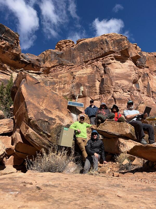
USGS team that installed a new streamgage near Moab, Utah
USGS team that installed a new streamgage near Moab, UtahUSGS crews that installed a streamgage on the North Fork of Mill Creek near Moab, Utah on February 21, 2025. The new monitoring system provides vital real-time data for flood warnings and public safety.
Repairing a streamgage during the Blue 2 Fire near Alto, New Mexico
Repairing a streamgage during the Blue 2 Fire near Alto, New MexicoA member of the USGS Water and Fire Technicians Team repairs a streamgage during the Blue 2 Fire near Alto, New Mexico.
Repairing a streamgage during the Blue 2 Fire near Alto, New Mexico
Repairing a streamgage during the Blue 2 Fire near Alto, New MexicoA member of the USGS Water and Fire Technicians Team repairs a streamgage during the Blue 2 Fire near Alto, New Mexico.

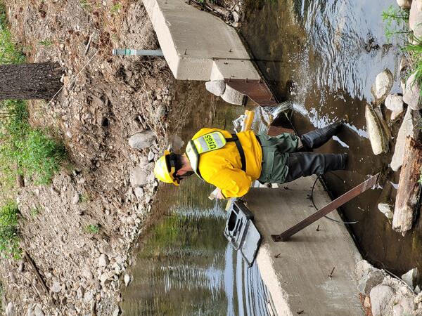
Inspecting equipment at streamgage 040871473 at Wilson Park Creek in Milwaukee, Wisconsin
Inspecting equipment at streamgage 040871473 at Wilson Park Creek in Milwaukee, WisconsinOwen Stefaniak inspects equipment at streamgage 040871473, Wilson Park Creek @ GMIA Infall at Milwaukee, Wisconsin. Wilson Park Creek at Gmia Infall at Milwaukee, WI - USGS Water Data for the Nation.

Streamgage repair on Bowlegs Creek near Ft. Meade, Florida (02295013)
Streamgage repair on Bowlegs Creek near Ft. Meade, Florida (02295013)Hydrologic Technician, Erik Ohlson, repairs a streamgage at Bowlegs Creek near Ft. Meade, Florida (02295013) after it was submerged by flooding from Hurricane Ian. The site is used to monitor water levels and compute discharge in cooperation with Southwest Florida Water Management District.

Installation of streamgage at Birch Creek
Hydrologist installs streamgage at Birch Creek below Heart Butte Road, near Heart Butte, MT (06094900) as part of the surface water phase of the Hydrologic Assessment of the Blackfeet Reservation, Montana project.
Hydrologist installs streamgage at Birch Creek below Heart Butte Road, near Heart Butte, MT (06094900) as part of the surface water phase of the Hydrologic Assessment of the Blackfeet Reservation, Montana project.

How USGS Streamgages Work
This video explains how streamgages are used to measure the height and flow, or speed, of streams. By monitoring the height and flow of streams, the people who manage water infrastructure can have advanced noted of when the water is rising and how fast it’s coming.
This video explains how streamgages are used to measure the height and flow, or speed, of streams. By monitoring the height and flow of streams, the people who manage water infrastructure can have advanced noted of when the water is rising and how fast it’s coming.

Streamgage Installation
Installation of USGS streamflow gaging station 06098120 Birch Creek at Bullhead Bridge near Valier, MT.
Installation of USGS streamflow gaging station 06098120 Birch Creek at Bullhead Bridge near Valier, MT.

USGS Streamgage 03011000 at Snake River, WY

Streamgages: The Silent Superhero
Whether you drink water from your tap, use electricity or canoe down your local river, chances are you benefit from USGS streamgage information. So what is a streamgage and what does it do for you? This CoreCast episode gives you the inside scoop on your silent superhero.
Transcript and captions available soon.
Related
How do we benefit from USGS streamgages? How do we benefit from USGS streamgages?
Information on the flow of rivers is a vital national asset that safeguards lives, protects property, and ensures adequate water supplies for the future. The USGS is the federal agency responsible for operating a network of about 7,000 streamgages nationwide. Data from this network are used by water managers, emergency responders, utilities, environmental agencies, universities, consulting firms...
What does the term "stream stage" mean? What does the term "stream stage" mean?
Stream stage (aka gage height) is an important concept when analyzing how much water is moving in a stream at any given moment. "Stage" is the water level above some arbitrary point in the river and is commonly measured in feet. For example, on a normal day when no rain has fallen for a while, a river might have a stage of 2 feet. If a big storm hits, the river stage could rise to 15 or 20 feet...
Why do some real-time streamgaging stations stop transmitting data for extended periods of time? Why do some real-time streamgaging stations stop transmitting data for extended periods of time?
The USGS usually corrects any equipment or station problems at our streamgages within a few days of their occurrence. Occasionally, replacement parts or equipment might not be readily available, or a station might be inaccessible due to weather conditions. Most USGS streamgaging stations are operated in cooperation with other agencies. At some stations, the stage transmitting equipment is owned...
Does "stage" tell you how much water is flowing in a stream? Does "stage" tell you how much water is flowing in a stream?
Not directly. You cannot say that because a stream rises (doubles) from a 10-foot stage to a 20-foot stage that the amount of flowing water also doubles. Think of a cereal bowl with a rounded bottom. Pour one inch of milk in it. It doesn't take much milk to make it up to the one inch level because the bowl is at its narrowest near the bottom. Now, pour in milk until it is two inches deep -- it...
Where can I get real-time and historical streamflow information? Where can I get real-time and historical streamflow information?
Water Data for the Nation (WDFN) is the home for USGS streamflow, groundwater, and water quality data. Through WDFN you can find different tools to look at historic and real-time streamflow data, find sites of interest, and access using USGS water data application programming interfaces (APIs). State pages (e.g., California) allow you to discover real-time data in your state, or you can create a...
How often are real-time streamflow data updated? How often are real-time streamflow data updated?
USGS real-time streamflow data are typically recorded at 15-minute intervals, stored onsite, and then transmitted to USGS offices once every hour, depending on the data relay technique used. Recording and transmission times might be more frequent during critical events (floods, for example). Data from current sites are relayed to USGS offices via satellite, telephone, and/or radio telemetry and...
Installing New Streamgage on Martha's Vineyard
USGS staff installing a new streamgage on the island of Martha's Vineyard in Massachusetts. This streamgage is a part of the state’s cooperative hydrologic monitoring network with USGS.
USGS staff installing a new streamgage on the island of Martha's Vineyard in Massachusetts. This streamgage is a part of the state’s cooperative hydrologic monitoring network with USGS.
USGS team that installed a new streamgage near Moab, Utah
USGS team that installed a new streamgage near Moab, UtahUSGS crews that installed a streamgage on the North Fork of Mill Creek near Moab, Utah on February 21, 2025. The new monitoring system provides vital real-time data for flood warnings and public safety.
Repairing a streamgage during the Blue 2 Fire near Alto, New Mexico
Repairing a streamgage during the Blue 2 Fire near Alto, New MexicoA member of the USGS Water and Fire Technicians Team repairs a streamgage during the Blue 2 Fire near Alto, New Mexico.
Repairing a streamgage during the Blue 2 Fire near Alto, New Mexico
Repairing a streamgage during the Blue 2 Fire near Alto, New MexicoA member of the USGS Water and Fire Technicians Team repairs a streamgage during the Blue 2 Fire near Alto, New Mexico.
Inspecting equipment at streamgage 040871473 at Wilson Park Creek in Milwaukee, Wisconsin
Inspecting equipment at streamgage 040871473 at Wilson Park Creek in Milwaukee, WisconsinOwen Stefaniak inspects equipment at streamgage 040871473, Wilson Park Creek @ GMIA Infall at Milwaukee, Wisconsin. Wilson Park Creek at Gmia Infall at Milwaukee, WI - USGS Water Data for the Nation.
Streamgage repair on Bowlegs Creek near Ft. Meade, Florida (02295013)
Streamgage repair on Bowlegs Creek near Ft. Meade, Florida (02295013)Hydrologic Technician, Erik Ohlson, repairs a streamgage at Bowlegs Creek near Ft. Meade, Florida (02295013) after it was submerged by flooding from Hurricane Ian. The site is used to monitor water levels and compute discharge in cooperation with Southwest Florida Water Management District.
Installation of streamgage at Birch Creek
Hydrologist installs streamgage at Birch Creek below Heart Butte Road, near Heart Butte, MT (06094900) as part of the surface water phase of the Hydrologic Assessment of the Blackfeet Reservation, Montana project.
Hydrologist installs streamgage at Birch Creek below Heart Butte Road, near Heart Butte, MT (06094900) as part of the surface water phase of the Hydrologic Assessment of the Blackfeet Reservation, Montana project.
How USGS Streamgages Work
This video explains how streamgages are used to measure the height and flow, or speed, of streams. By monitoring the height and flow of streams, the people who manage water infrastructure can have advanced noted of when the water is rising and how fast it’s coming.
This video explains how streamgages are used to measure the height and flow, or speed, of streams. By monitoring the height and flow of streams, the people who manage water infrastructure can have advanced noted of when the water is rising and how fast it’s coming.
Streamgage Installation
Installation of USGS streamflow gaging station 06098120 Birch Creek at Bullhead Bridge near Valier, MT.
Installation of USGS streamflow gaging station 06098120 Birch Creek at Bullhead Bridge near Valier, MT.
USGS Streamgage 03011000 at Snake River, WY
Streamgages: The Silent Superhero
Whether you drink water from your tap, use electricity or canoe down your local river, chances are you benefit from USGS streamgage information. So what is a streamgage and what does it do for you? This CoreCast episode gives you the inside scoop on your silent superhero.
Transcript and captions available soon.
Whether you drink water from your tap, use electricity or canoe down your local river, chances are you benefit from USGS streamgage information. So what is a streamgage and what does it do for you? This CoreCast episode gives you the inside scoop on your silent superhero.
Transcript and captions available soon.
Updated Date: July 30, 2025