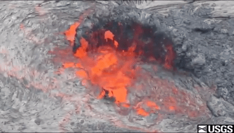
The Hawaiian shield volcanoes are the largest mountains on Earth.
Mauna Kea Volcano rises 13,796 feet (4,205 meters) above sea level but extends about 19,700 feet (6,000 meters) below sea level to meet the deep ocean floor. Its total height is nearly 33,500 feet (10,211 meters), considerably higher than the height of the tallest mountain on land, Mount Everest (Chomolungma in Tibetan) in the Himalayas, which is 29,029 feet (8,848 meters) above sea level.
Mauna Loa Volcano stands not quite as high as Mauna Kea but is much larger in volume.
Related Content
How hot is a Hawaiian volcano?
Very hot!! Here are some temperatures recorded at different times and locations: The eruption temperature of Kīlauea lava is about 1,170 degrees Celsius (2,140 degrees Fahrenheit). The temperature of the lava in the tubes is about 1,250 degrees Celsius (2,200 degrees Fahrenheit). The tube system of episode 53 (Pu'u O'o eruption) carried lava for 10 kilometers (6 miles) from the vent to the sea...
How can we tell when a volcano will erupt?
Most volcanoes provide warnings before an eruption. Magmatic eruptions involve the rise of magma toward the surface, which normally generates detectable earthquakes. It can also deform the ground surface and cause anomalous heat flow or changes in the temperature and chemistry of the groundwater and spring waters. Steam-blast eruptions, however, can occur with little or no warning as superheated...
Why is it important to monitor volcanoes?
There are 161 potentially active volcanoes in the United States. According to a 2018 USGS assessment, 57 volcanoes are a high threat or very high threat to public safety. Many of these volcanoes have erupted in the recent past and will erupt again in the foreseeable future. As populations increase, areas near volcanoes are being developed and aviation routes are increasing. As a result, more...
Is it dangerous to work on volcanoes? What precautions do scientists take?
Volcanoes are inherently beautiful places where forces of nature combine to produce awesome events and spectacular landscapes. For volcanologists, they're FUN to work on! Safety is, however, always the primary concern because volcanoes can be dangerous places. USGS scientists try hard to understand the risk inherent in any situation, then train and equip themselves with the tools and support...
What was the most destructive volcanic eruption in the history of the United States?
The May 18, 1980 eruption of Mount St. Helens (Washington) was the most destructive in the history of the United States. Novarupta (Katmai) Volcano in Alaska erupted considerably more material in 1912, but owing to the isolation and sparse population of the region, there were no human deaths and little property damage. In contrast, the eruption of Mount St. Helens caused loss of lives and...
How many active volcanoes are there on Earth?
There are about 1,350 potentially active volcanoes worldwide, aside from the continuous belts of volcanoes on the ocean floor at spreading centers like the Mid-Atlantic Ridge. About 500 of those 1,350 volcanoes have erupted in historical time. Many of those are located along the Pacific Rim in what is known as the "Ring of Fire." In the United States, volcanoes in the Cascade Range and Alaska...
Which volcanic eruptions were the deadliest?
Deadliest Volcanic Eruptions Since 1500 A.D. Eruption Year Casualties Major Cause Nevado del Ruiz, Colombia 1985 25,0001,3 Mudflows3 Mont Pelée, Martinique 1902 30,0001 (29,025)2 Pyroclastic flows2 Krakatau, Indonesia 1883 36,0001 (36,417)2 Tsunami2 Tambora, Indonesia 1815 92,0001,2 Starvation2 Unzendake, Japan 1792 15,0001 (14,030)2 Volcano collapse, Tsunami2 Lakagigar (Laki), Iceland 1783 9,0001...
What was the largest volcanic eruption in the 20th century?
The world's largest eruption of the 20th century occurred in 1912 at Novarupta on the Alaska Peninsula in what is now Katmai National Park and Preserve. An estimated 15 cubic kilometers of magma was explosively erupted during 60 hours beginning on June 6th. This volume is equivalent to 230 years of eruption at Kilauea (Hawaii) or about 30 times the volume erupted by Mount St. Helens (Washington)...
Which volcanoes in the conterminous United States have erupted since the Nation was founded?
Excluding steam eruptions, these volcanoes have shown activity: Mount St. Helens, Washington - Eruptions and/or lava dome growth occurred in the late 1700s, 1800-1857, 1980-1986, and 2004-2008. Lassen Peak, California - A series of steam blasts began on May 30, 1914. An eruption occurred 12 months later on May 21, 1915. Minor activity continued through the middle of 1917. Mount Hood, Oregon -...
What kind of school training do you need to become a volcanologist?
There are many paths to becoming a volcanologist. Most include a college or graduate school education in a scientific or technical field, but the range of specialties is very large. Training in geology, geophysics, geochemistry, biology, biochemistry, mathematics, statistics, engineering, atmospheric science, remote sensing, and related fields can be applied to the study of volcanoes and the...
Where is the largest active volcano in the world?
Rising gradually to more than 4 km (2.5 mi) above sea level, Hawaii’s Mauna Loa is the largest active volcano on our planet. Its submarine flanks descend to the sea floor an additional 5 km (3 mi), and the sea floor in turn is depressed by Mauna Loa's great mass another 8 km (5 mi). This makes the volcano's summit about 17 km (10.5 mi) above its base! Learn more: USGS Hawaiian Volcano Observatory
A decade of geodetic change at Kīlauea’s summit—Observations, interpretations, and unanswered questions from studies of the 2008–2018 Halemaʻumaʻu eruption
Views of a century of activity at Kīlauea Caldera—A visual essay
Groundwater dynamics at Kīlauea Volcano and vicinity, Hawaiʻi
Kīlauea’s 2008–2018 summit lava lake—Chronology and eruption insights
Living with volcano hazards
Undocumented late 18th- to early 19th-century volcanic eruptions in the Southwest Rift Zone of Kīlauea Volcano, Hawai‘i
2018 update to the U.S. Geological Survey national volcanic threat assessment
When erupting, all volcanoes pose a degree of risk to people and infrastructure, however, the risks are not equivalent from one volcano to another because of differences in eruptive style and geographic location. Assessing the relative threats posed by U.S. volcanoes identifies which volcanoes warrant the greatest risk-mitigation efforts by the U.S. Geological Survey and its partners. This update
Characteristics of Hawaiian volcanoes
Mauna Loa--history, hazards and risk of living with the world's largest volcano
The story of the Hawaiian Volcano Observatory -- A remarkable first 100 years of tracking eruptions and earthquakes
Eruptions of Hawaiian volcanoes - Past, present, and future
Elevations and Distances
Related Content
- FAQ
How hot is a Hawaiian volcano?
Very hot!! Here are some temperatures recorded at different times and locations: The eruption temperature of Kīlauea lava is about 1,170 degrees Celsius (2,140 degrees Fahrenheit). The temperature of the lava in the tubes is about 1,250 degrees Celsius (2,200 degrees Fahrenheit). The tube system of episode 53 (Pu'u O'o eruption) carried lava for 10 kilometers (6 miles) from the vent to the sea...
How can we tell when a volcano will erupt?
Most volcanoes provide warnings before an eruption. Magmatic eruptions involve the rise of magma toward the surface, which normally generates detectable earthquakes. It can also deform the ground surface and cause anomalous heat flow or changes in the temperature and chemistry of the groundwater and spring waters. Steam-blast eruptions, however, can occur with little or no warning as superheated...
Why is it important to monitor volcanoes?
There are 161 potentially active volcanoes in the United States. According to a 2018 USGS assessment, 57 volcanoes are a high threat or very high threat to public safety. Many of these volcanoes have erupted in the recent past and will erupt again in the foreseeable future. As populations increase, areas near volcanoes are being developed and aviation routes are increasing. As a result, more...
Is it dangerous to work on volcanoes? What precautions do scientists take?
Volcanoes are inherently beautiful places where forces of nature combine to produce awesome events and spectacular landscapes. For volcanologists, they're FUN to work on! Safety is, however, always the primary concern because volcanoes can be dangerous places. USGS scientists try hard to understand the risk inherent in any situation, then train and equip themselves with the tools and support...
What was the most destructive volcanic eruption in the history of the United States?
The May 18, 1980 eruption of Mount St. Helens (Washington) was the most destructive in the history of the United States. Novarupta (Katmai) Volcano in Alaska erupted considerably more material in 1912, but owing to the isolation and sparse population of the region, there were no human deaths and little property damage. In contrast, the eruption of Mount St. Helens caused loss of lives and...
How many active volcanoes are there on Earth?
There are about 1,350 potentially active volcanoes worldwide, aside from the continuous belts of volcanoes on the ocean floor at spreading centers like the Mid-Atlantic Ridge. About 500 of those 1,350 volcanoes have erupted in historical time. Many of those are located along the Pacific Rim in what is known as the "Ring of Fire." In the United States, volcanoes in the Cascade Range and Alaska...
Which volcanic eruptions were the deadliest?
Deadliest Volcanic Eruptions Since 1500 A.D. Eruption Year Casualties Major Cause Nevado del Ruiz, Colombia 1985 25,0001,3 Mudflows3 Mont Pelée, Martinique 1902 30,0001 (29,025)2 Pyroclastic flows2 Krakatau, Indonesia 1883 36,0001 (36,417)2 Tsunami2 Tambora, Indonesia 1815 92,0001,2 Starvation2 Unzendake, Japan 1792 15,0001 (14,030)2 Volcano collapse, Tsunami2 Lakagigar (Laki), Iceland 1783 9,0001...
What was the largest volcanic eruption in the 20th century?
The world's largest eruption of the 20th century occurred in 1912 at Novarupta on the Alaska Peninsula in what is now Katmai National Park and Preserve. An estimated 15 cubic kilometers of magma was explosively erupted during 60 hours beginning on June 6th. This volume is equivalent to 230 years of eruption at Kilauea (Hawaii) or about 30 times the volume erupted by Mount St. Helens (Washington)...
Which volcanoes in the conterminous United States have erupted since the Nation was founded?
Excluding steam eruptions, these volcanoes have shown activity: Mount St. Helens, Washington - Eruptions and/or lava dome growth occurred in the late 1700s, 1800-1857, 1980-1986, and 2004-2008. Lassen Peak, California - A series of steam blasts began on May 30, 1914. An eruption occurred 12 months later on May 21, 1915. Minor activity continued through the middle of 1917. Mount Hood, Oregon -...
What kind of school training do you need to become a volcanologist?
There are many paths to becoming a volcanologist. Most include a college or graduate school education in a scientific or technical field, but the range of specialties is very large. Training in geology, geophysics, geochemistry, biology, biochemistry, mathematics, statistics, engineering, atmospheric science, remote sensing, and related fields can be applied to the study of volcanoes and the...
Where is the largest active volcano in the world?
Rising gradually to more than 4 km (2.5 mi) above sea level, Hawaii’s Mauna Loa is the largest active volcano on our planet. Its submarine flanks descend to the sea floor an additional 5 km (3 mi), and the sea floor in turn is depressed by Mauna Loa's great mass another 8 km (5 mi). This makes the volcano's summit about 17 km (10.5 mi) above its base! Learn more: USGS Hawaiian Volcano Observatory
- Multimedia
- Publications
A decade of geodetic change at Kīlauea’s summit—Observations, interpretations, and unanswered questions from studies of the 2008–2018 Halemaʻumaʻu eruption
On March 19, 2008, a small explosion heralded the onset of an extraordinary eruption at the summit of Kīlauea Volcano. The following 10 years provided unprecedented access to an actively circulating lava lake located within a region monitored by numerous geodetic tools, including Global Navigation Satellite System (GNSS), interferometric synthetic aperture radar (InSAR), tilt, and gravity. These dAuthorsMichael P. Poland, Asta Miklius, Ingrid A. Johanson, Kyle R. AndersonViews of a century of activity at Kīlauea Caldera—A visual essay
The 2018 eruption of Kīlauea Volcano marked the end of the first sustained period of volcanic activity at Halemaʻumaʻu Crater in 94 years. The views of the lava lake (informally named “Overlook,” nestled within Halemaʻumaʻu) lasted for a decade and seemed timeless. But as we were recently reminded, the summit of Kīlauea is part of a dynamic system that has provided countless new views to observersAuthorsBen Gaddis, James P. KauahikauaGroundwater dynamics at Kīlauea Volcano and vicinity, Hawaiʻi
Kīlauea Volcano, on the Island of Hawaiʻi, is surrounded and permeated by active groundwater systems that interact dynamically with the volcanic system. A generalized conceptual model of Hawaiian hydrogeology includes high-level dike-impounded groundwater, very permeable perched and basal aquifers, and a transition (mixing) zone between freshwater and saltwater. Most high-level groundwater is assoAuthorsShaul Hurwitz, Sara E. Peek, Martha A. Scholl, Deborah Bergfeld, William C. Evans, James P. Kauahikaua, Stephen B. Gingerich, Paul A. Hsieh, R. Lopaka Lee, Edward F. Younger, Steven E. IngebritsenKīlauea’s 2008–2018 summit lava lake—Chronology and eruption insights
The first eruption at Kīlauea’s summit in 25 years began on March 19, 2008, and persisted for 10 years. The onset of the eruption marked the first explosive activity at the summit since 1924, forming the new “Overlook crater” (as the 2008 summit eruption crater has been informally named) within the existing crater of Halemaʻumaʻu. The first year consisted of sporadic lava activity deep within theAuthorsMatthew R. Patrick, Tim R. Orr, Don Swanson, Bruce F. Houghton, Kelly M. Wooten, Liliana G. Desmither, Carolyn Parcheta, David FeeLiving with volcano hazards
Volcanic eruptions are among Earth’s most dramatic and powerful agents of change. Ash, mudflows, and lava flows can devastate communities near volcanoes and cause havoc in areas far downwind, downstream, and downslope. Even when a volcano is quiet, steep volcanic slopes can collapse to become landslides, and large rocks can be hurled by powerful steam blasts. Hazardous volcanic conditions might laAuthorsWendy K. Stovall, Carolyn L. Driedger, Elizabeth G. Westby, Lisa M. FaustUndocumented late 18th- to early 19th-century volcanic eruptions in the Southwest Rift Zone of Kīlauea Volcano, Hawai‘i
The historical record of volcanic activity at Kīlauea Volcano on the Island of Hawaiʻi begins with the phreatomagmatic blasts of 1790. Three decades later, in 1823, the first party of non-Hawaiian visitors, organized by the English Reverend William Ellis, reached Kīlauea’s summit. A detailed narrative by Ellis includes an account of an eruption in Kīlauea’s Southwest Rift Zone that occurred shortlAuthorsRichard W. Hazlett, Tim R. Orr, Steve P. Lundblad2018 update to the U.S. Geological Survey national volcanic threat assessment
When erupting, all volcanoes pose a degree of risk to people and infrastructure, however, the risks are not equivalent from one volcano to another because of differences in eruptive style and geographic location. Assessing the relative threats posed by U.S. volcanoes identifies which volcanoes warrant the greatest risk-mitigation efforts by the U.S. Geological Survey and its partners. This update
AuthorsJohn W. Ewert, Angela K. Diefenbach, David W. RamseyByVolcano Hazards Program, Volcano Science Center, Agrigan, Ahyi Seamount, Alamagan, Anatahan, Asuncion, Belknap, Black Butte Crater Lava Field, Black Rock Desert Volcanic Field, Blue Lake Crater, Carrizozo Lava Flow, Cascade Range Weekly Update, Cinnamon Butte, Clear Lake Volcanic Field, Coso Volcanic Field, Crater Lake, Craters of the Moon Volcanic Field, Daikoku Seamount , Davis Lake Volcanic Field, Devils Garden Lava Field, Diamond Craters Volcanic Field, Dotsero Volcanic Center, East Diamante, Esmeralda Bank, Farallon de Pajaros, Fukujin Seamount , Glacier Peak, Guguan, Haleakalā, Hell's Half Acre Lava Field, Hualālai, Indian Heaven Volcanic Field, Jordan Craters Volcanic Field, Kama‘ehuakanaloa, Kasuga 2, Kīlauea, Lassen Volcanic Center, Long Valley Caldera, Mammoth Mountain, Markagunt Plateau Volcanic Field, Maug Islands, Mauna Kea, Mauna Loa, Medicine Lake, Mono Lake Volcanic Field, Mono-Inyo Craters, Mount Adams, Mount Bachelor, Mount Baker, Mount Hood, Mount Jefferson, Mount Rainier, Mount Shasta, Mount St. Helens, Newberry, Ofu-Olosega, Pagan, Red Hill-Quemado Volcanic Field, Ruby, Salton Buttes, San Francisco Volcanic Field, Sand Mountain Volcanic Field, Sarigan, Soda Lakes, South Sarigan Seamount, Supply Reef, Ta'u Island, Three Sisters, Tutuila Island, Ubehebe Craters, Uinkaret Volcanic Field, Valles Caldera, Wapi Lava Field, Weekly Update, West Crater Volcanic Field, Yellowstone, Zealandia Bank, Zuni-Bandera Volcanic FieldCharacteristics of Hawaiian volcanoes
Founded in 1912 at the edge of the caldera of Kīlauea Volcano, HVO was the vision of Thomas A. Jaggar, Jr., a geologist from the Massachusetts Institute of Technology, whose studies of natural disasters around the world had convinced him that systematic, continuous observations of seismic and volcanic activity were needed to better understand—and potentially predict—earthquakes and volcanic eruptiMauna Loa--history, hazards and risk of living with the world's largest volcano
Mauna Loa on the Island Hawaiʻi is the world’s largest volcano. People residing on its flanks face many hazards that come with living on or near an active volcano, including lava flows, explosive eruptions, volcanic smog, damaging earthquakes, and local tsunami (giant seawaves). The County of Hawaiʻi (Island of Hawaiʻi) is the fastest growing County in the State of Hawaii. Its expanding populationAuthorsFrank A. TrusdellThe story of the Hawaiian Volcano Observatory -- A remarkable first 100 years of tracking eruptions and earthquakes
The year 2012 marks the centennial of the Hawaiian Volcano Observatory (HVO). With the support and cooperation of visionaries, financiers, scientists, and other individuals and organizations, HVO has successfully achieved 100 years of continuous monitoring of Hawaiian volcanoes. As we celebrate this milestone anniversary, we express our sincere mahalo—thanks—to the people who have contributed to aAuthorsJanet L. Babb, James P. Kauahikaua, Robert I. TillingEruptions of Hawaiian volcanoes - Past, present, and future
Viewing an erupting volcano is a memorable experience, one that has inspired fear, superstition, worship, curiosity, and fascination since before the dawn of civilization. In modern times, volcanic phenomena have attracted intense scientific interest, because they provide the key to understanding processes that have created and shaped more than 80 percent of the Earth's surface. The active HawaiiaAuthorsRobert I. Tilling, Christina Heliker, Donald A. SwansonElevations and Distances
Photographs and other images of the Earth taken from the air and from space show a great deal about the planet's landforms, vegetation, and resources. Aerial and satellite images, known as remotely sensed images, permit accurate mapping of land cover and make landscape features understandable on regional, continental, and even global scales. Transient phenomena, such as seasonal vegetation vigor aAuthors - News