PubTalk-06/2023: Next Generation Topographic Mapping
PubTalk-06/2023: Next Generation Topographic MappingMap what you want, where you want, when you want with topoBuilder
Learn About:

Official websites use .gov
A .gov website belongs to an official government organization in the United States.
Secure .gov websites use HTTPS
A lock () or https:// means you’ve safely connected to the .gov website. Share sensitive information only on official, secure websites.
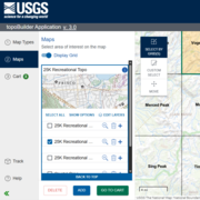
OnDemand Topos are USGS topographic maps generated on demand (at no cost) using the topoBuilder application and the best available data from The National Map. The ability to customize your map and center it wherever you choose is exclusive to topoBuilder.
OnDemand Topo map extents do not need to align with the traditional grids utilized by US Topos and other USGS topographic maps. Once a map has been built and requested through topoBuilder, it will be digitally delivered by email. Maps are often delivered within 24 hours but can take up to 5 business days.

In the lower 48 States, orthoimages (rectified air photographs) for US Topo maps and OnDemand Topo maps comes from the National Agriculture Imagery Program (NAIP). There are areas over some military installations where NAIP imagery is not available. In these locations, the OnDemand Topo maps will either not include imagery or contain partial imagery. US Topo maps are only produced for areas that...
USGS OnDemand Topo maps and USGS US Topo maps are built using similar datasets but can look different depending on what areas or options the user selects. OnDemand Topos--created using the topoBuilder application--offer customizations such as custom extents, a variety of scales, contour smoothing, and user-selected data layers. They include U.S. Territory coverage that is not available on US...

US Topo maps are updated on a three-year production cycle (maps covering one third of the country are updated each year). The US Topo production schedule follows the U.S. Department of Agriculture's National Agricultural Imagery Program (NAIP) collection schedule. This does not include US Topos for Alaska, which are on a different schedule. The linework features shown on the maps are generated...

USDA Forest Service Visitor Maps are at a smaller scale (they show a larger area but less detail) than standard 7.5-minute (1:24,000-scale) USGS topographic maps. Unlike USGS topographic maps, Forest Service Visitor maps typically do not show elevation contours. U.S. Forest Service Visitor Maps include recreational information about camping, fishing, biking, and other outdoor activities. They...

Yes, US Topo products are available for all of Alaska. Publication of 1:25,000-scale US Topo maps in Alaska began in 2013. The production schedule is determined by availability of IFSAR elevation data and SPOT imagery provided by the Alaska Statewide Digital Mapping Initiative. To see an index map of publication dates for US Topos in Alaska, go to the National Map Downloader. Put a checkmark next...

Map what you want, where you want, when you want with topoBuilder
Learn About:
Map what you want, where you want, when you want with topoBuilder
Learn About:

One Custom Extent OnDemand Topo (right) containing relevant portions of four US Topo quadrangles (left) in the Reston, Virginia area.
One Custom Extent OnDemand Topo (right) containing relevant portions of four US Topo quadrangles (left) in the Reston, Virginia area.

The U.S. Geological Survey’s National Geospatial Program has released the topoBuilder application, which enables users to create topographic maps on demand using the best available National Map data.
The U.S. Geological Survey’s National Geospatial Program has released the topoBuilder application, which enables users to create topographic maps on demand using the best available National Map data.

topoBuilder & OnDemand Topo Capabilities
topoBuilder & OnDemand Topo Capabilities

A comparison of low, medium (default), and high contour smoothing options available from the topoBuilder application.
A comparison of low, medium (default), and high contour smoothing options available from the topoBuilder application.

topoBuilder & OnDemand Topo Capabilities
topoBuilder & OnDemand Topo Capabilities
In the lower 48 States, orthoimages (rectified air photographs) for US Topo maps and OnDemand Topo maps comes from the National Agriculture Imagery Program (NAIP). There are areas over some military installations where NAIP imagery is not available. In these locations, the OnDemand Topo maps will either not include imagery or contain partial imagery. US Topo maps are only produced for areas that...
USGS OnDemand Topo maps and USGS US Topo maps are built using similar datasets but can look different depending on what areas or options the user selects. OnDemand Topos--created using the topoBuilder application--offer customizations such as custom extents, a variety of scales, contour smoothing, and user-selected data layers. They include U.S. Territory coverage that is not available on US...
US Topo maps are updated on a three-year production cycle (maps covering one third of the country are updated each year). The US Topo production schedule follows the U.S. Department of Agriculture's National Agricultural Imagery Program (NAIP) collection schedule. This does not include US Topos for Alaska, which are on a different schedule. The linework features shown on the maps are generated...
USDA Forest Service Visitor Maps are at a smaller scale (they show a larger area but less detail) than standard 7.5-minute (1:24,000-scale) USGS topographic maps. Unlike USGS topographic maps, Forest Service Visitor maps typically do not show elevation contours. U.S. Forest Service Visitor Maps include recreational information about camping, fishing, biking, and other outdoor activities. They...
Yes, US Topo products are available for all of Alaska. Publication of 1:25,000-scale US Topo maps in Alaska began in 2013. The production schedule is determined by availability of IFSAR elevation data and SPOT imagery provided by the Alaska Statewide Digital Mapping Initiative. To see an index map of publication dates for US Topos in Alaska, go to the National Map Downloader. Put a checkmark next...
Map what you want, where you want, when you want with topoBuilder
Learn About:
Map what you want, where you want, when you want with topoBuilder
Learn About:
One Custom Extent OnDemand Topo (right) containing relevant portions of four US Topo quadrangles (left) in the Reston, Virginia area.
One Custom Extent OnDemand Topo (right) containing relevant portions of four US Topo quadrangles (left) in the Reston, Virginia area.
The U.S. Geological Survey’s National Geospatial Program has released the topoBuilder application, which enables users to create topographic maps on demand using the best available National Map data.
The U.S. Geological Survey’s National Geospatial Program has released the topoBuilder application, which enables users to create topographic maps on demand using the best available National Map data.
topoBuilder & OnDemand Topo Capabilities
topoBuilder & OnDemand Topo Capabilities
A comparison of low, medium (default), and high contour smoothing options available from the topoBuilder application.
A comparison of low, medium (default), and high contour smoothing options available from the topoBuilder application.
topoBuilder & OnDemand Topo Capabilities
topoBuilder & OnDemand Topo Capabilities